Showing 2841 items
matching wests road
-
 Melbourne Tram Museum
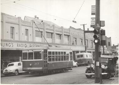
Photograph - Black & White Photograph/s, CLC, early 1950's?
... to the west of Geelong Road. Note the tram and bus stop signs... at Footscray. / In Barkly St Cnr Commercial Road, immediately west... Road, immediately west of Geelong Road. / /5" Has KSK number ...Photograph, Black and White, Birney No. 217 on the Russell St route, Footscray in Barkly St , Cnr Commercial road, just to the west of Geelong Road. Note the tram and bus stop signs on the pole with the traffic lights, and the bus in front of the tram. One of the buildings has an "Ealing's radio electrical sign" Early 1950's?In ink on the rear: "MMTB X217 on Russell Street route at Footscray. / In Barkly St Cnr Commercial Road, immediately west of Geelong Road. / /5" Has KSK number CLC36 in to right hand corner.trams, tramways, footscray, birney, tram stops, bus stops, russell st, barkly st, buses, tram 217 -
 Whitehorse Historical Society Inc.
Photograph, Blackburn Railway Station, 6/01/2001 12:00:00 AM
... looking west from Blackburn Road, Blackburn....Whitehorse Historical Society Inc. 2-10 Deep Creek Road ...Black and white photograph of Blackburn Railway Station looking west from Blackburn Road, Blackburn.blackburn railway station -
 Bendigo Historical Society Inc.
Photograph - GOLDEN SQUARE HIGH SCHOOL COLLECTION: 25.11.61, 1961
... Photograph. GSHS, 25.11.1961. Looking west from down... Photograph. GSHS, 25.11.1961. Looking west from down the road ...Photograph. GSHS, 25.11.1961. Looking west from down the road. -
 Eltham District Historical Society Inc
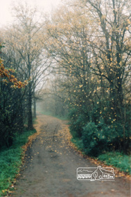
Photograph, Diamond Creek Trail, Eltham
... opposite Dalton Street west of Main Road... of Diamond Creek Trail opposite Dalton Street west of Main Road ...Colour photograph of Autumn view of Diamond Creek Trail opposite Dalton Street west of Main Roaddalton street, walkways -
 Eltham District Historical Society Inc
Photograph, Eltham (Bridge Street)
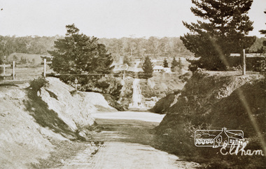
... Street, Eltham looking west from Main Road... melbourne eltham bridge street main road Colour photograph ...Colour photograph of an original sepia image of Bridge Street, Eltham looking west from Main Roadeltham, bridge street, main road -
 Whitehorse Historical Society Inc.
Photograph, Blossom Street, Mitcham, 4/01/2001 12:00:00 AM
... Three streets West of Heatherdale Road - running north...Whitehorse Historical Society Inc. 2-10 Deep Creek Road ...Three streets West of Heatherdale Road - running north and south - one street east of Purches Street.blossom street, mitcham. -
 Ringwood and District Historical Society
Newspaper, Newspaper articles detailing the acquisition of 40 acres of land for Jubilee Park, formerly known as Sanders Estate, for recreation purposes
... . The area included named streets - Prussia Road (not West Prussia... - Prussia Road (not West Prussia Road), Duffy Street, Ireland Street ...Various newspaper articles about detals of the acquisition, by Ringwood Council, of 40 acres of land for Jubilee Park, formerly known as Sanders Estate, for recreation purposes in 1945-1959. The area included named streets - Prussia Road (not West Prussia Road), Duffy Street, Ireland Street, Evens Street and Chapman Street. -
 Whitehorse Historical Society Inc.
Map, before 1890
... Road in the west, Burwood Road to the south to north... Heatherdale Road in the east and Springvale Road in the west, Burwood ...Early map showing location and areas of plots and their owners' names between Heatherdale Road in the east and Springvale Road in the west, Burwood Road to the south to north of Canterbury Road. Later additions to 1969Early map showing location and areas of plots and their owners' names between Heatherdale Road in the east and Springvale Road in the west, Burwood Road to the south to north of Canterbury Road. Later additions to 1969Early map showing location and areas of plots and their owners' names between Heatherdale Road in the east and Springvale Road in the west, Burwood Road to the south to north of Canterbury Road. Later additions to 1969mitcham, vermont, nunawading -
 Whitehorse Historical Society Inc.
Photograph, Deep Creek Road, 1/04/2001 12:00:00 AM
... Coloured photograph looking West from Deep Creek Road... looking West from Deep Creek Road Bridge. Deep Creek Road ...Coloured photograph looking West from Deep Creek Road Bridge.deep creek road, mitcham -
Mission to Seafarers Victoria
Letter - Correspondence, 1947
... Envelope addressed C/- Mrs Blackmore 140 Brunswick Road... 1947 Envelope addressed C/- Mrs Blackmore 140 Brunswick Road ...Quinn CollectionTwo-page, double-sided letter on unlined paper (0363a1-a2) written on board S.S.Morgenster, Mozambique dated 04/12/47 with blue-lined envelope (0363.b). Envelope is unstamped.Envelope addressed C/- Mrs Blackmore 140 Brunswick Road, West Brunswick, Victorialetters-from-abroad, quinn, s.s.morgenster, 1947 -
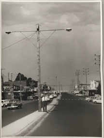
 Melbourne Tram Museum
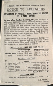
Document - Notice to Passengers, Melbourne & Metropolitan Tramways Board (MMTB), "Replacement of Footscray - Moonee Ponds Bus Service by a Tram", 27/4/1954
... of the section between Gordon Road and Wests Road from Sunday 2/5/1954... of the section between Gordon Road and Wests Road from Sunday 2/5/1954 ...Notice to Passengers titled "Replacement of Footscray - Moonee Ponds Bus Service by a Tram", about the opening of the section between Gordon Road and Wests Road from Sunday 2/5/1954. Provides details of the first and last trams, sections and fares and services to the Explosives Factory. Dated 27/4/1954, signed F G Wraith as Manager.Yields information about the opening of the connection between Gordon St and Wests Road.Notice - printed on foolscap size paper with handwritten initials in top left hand corner.Has "Rigaldi" in pencil.tramways, new tramways, route 82, footscray, explosives factory -
 Whitehorse Historical Society Inc.
Photograph, Whitehorse Road, Mitcham
... Coloured photo of Whitehorse Road, Mitcham, west of Station... of Whitehorse Road, Mitcham, west of Station Street. Taken 2003 ...Coloured photo of Whitehorse Road, Mitcham, west of Station Street. Taken 2003whitehorse road, mitcham -
 Melbourne Tram Museum
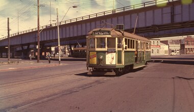
Photograph - Set of 3 Colour Negatives, Phil A'Vard, 10/02/1962 12:00:00 AM
... Wests Road. Taken on Perutz film - see 3997 for the AETA... Wests Road. Taken on Perutz film - see 3997 for the AETA ...Set of 3 photographs taken on the AETA tour Sat. 10/2/1962 - Closure of the Local Tram Routes at Footscray. .1 - W4 670 passing under the King St bridge in Queensbridge St, South Melbourne. Has an AETA tour Auxiliary board is showing Special. .2 - ditto, followed by W3 655 crossing the Maribyrnong Road Bridge. .3 - ditto - turning on the reserved track alongside Wests Road. Taken on Perutz film - see 3997 for the AETA Tour circular. and see 5998 for other photographs.trams, tramways, footscray, aeta, maribyrnong river bridge, maribyrnong rd, wests rd, queensbridge st, w4 class, w3 class, tram 670 -
 Melton City Libraries
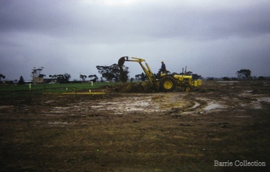
Photograph, Building a new school, 1974
... School, Coburns Road, Melton West..., Coburns Road, Melton West Building a new school Photograph Barrie ...There were no high schools in the area pre 1975, and students from Melton, Melton South and Toolern Vale State Schools went by bus to Bacchus Marsh High School. In 1975, Melton High School opened its doors. Coburn Road named after Coburns, early settlers family and George Coburn Councillor and 1935 Shire PresidentEarth works undertaken for the development of Melton High School, Coburns Road, Melton Westeducation -
 Whitehorse Historical Society Inc.
Photograph - Coloured photograph, Mullins Farmhouse East Burwood, 1982
... Burwood. West of Springvale Road. Mullens Orchard & home... Highway, East Burwood. West of Springvale Road. Mullens Orchard ...Coloured photo of Old House in Burwood Highway, East Burwood. West of Springvale Road. Mullens Orchard & home. House now demolished.orchards, mullens -
 Eltham District Historical Society Inc
Photograph - Aerial Photograph, Landata, Eltham, Vic, Apr. 1972
... Park West Road..., Eltham bounded by Allendale Road to north, Park West Road..., Eltham bounded by Allendale Road to north, Park West Road ...Centred on present day Zig Zag Road near Coolabah Drive, Eltham bounded by Allendale Road to north, Park West Road to south, Parsons Road to east and Banks Road to west. Historic Aerial Imagery Source: Landata.vic.gov.au Aerial Photo Details: Project No :985 Project : MELBOURNE 1972 Run : 26 Frame : 191 Date : 04/1972 Film Type : B/W Camera : RC10 Flying Height : 5700 Scale : 9600 Film Number : 2636 GDA2020 : 37°41'56"S, 145°09'26"E MGA2020 : 337533, 5826000 (55) Melways : 22 A1 (ed. 42)aerial photo, neil webster collection, 1972-04, allendale road, eltham, eltham north, zig zag road, banks road, coolabah drive, melway 22a1, park west road, parsons road -
 Eltham District Historical Society Inc
Photograph - Aerial Photograph, Landata, Eltham, Vic, Apr. 1972
... Park West Road... bounded by Park West Road to north, Napoleon Street to south... bounded by Park West Road to north, Napoleon Street to south ...Centred on present day Main Road at Pryor Street, Eltham bounded by Park West Road to north, Napoleon Street to south, Woodridge Estate to east and Ryans Road to west. Historic Aerial Imagery Source: Landata.vic.gov.au Aerial Photo Details: Project No :985 Project : MELBOURNE 1972 Run : 27 Frame : 47 Date : 04/1972 Film Type : B/W Camera : RC10 Flying Height : 5700 Scale : 9600 Film Number : 2636 GDA2020 : 37°42'45"S, 145°09'12"E MGA2020 : 337223, 5824470 (55) Melways : 22 A4 (ed. 42)aerial photo, neil webster collection, 1972-04, eltham, eltham railway station, woodridge estate, eltham shops, main road, melway 22a4, napoleon street, park west road, pryor street, ryans road -
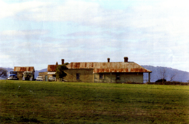
 Lakes Entrance Historical Society
Photograph - Settlers Home Kalimna West, M Fish, 1970 c
... buildings Kalimna Road Kalimna West Victoria... buildings Kalimna Road Kalimna West Victoria Settlers Home Kalimna ...Kalimna West was a thriving community 1900 to WW2 many farmers growing vegetables for local and Melbourne marketsColour photograph of derelict settlers home and out buildings Kalimna Road Kalimna West Victoriasettlers, houses -
 Kew Historical Society Inc
Photograph, Stuart Tompkins Studio, Electricity Supply Poles, North Road, Ormond, 1965
... by Stuart Tompkins Studio. The photograph of North Road, Ormond west..., west of Jasper Road, looking east. Wooden poles carrying two... Council 8/2/65. No.1 North Road - Ormond, west of Jasper Road ...Research provided by Stuart Tompkins Studio, Box Hill, into alternatives for median strip street lighting to be used in Burke Road, Kew. The photographers identified variants in different suburbs appropriate to Kew's needs.The series from which the photograph is drawn provides a snapshot by a commercial photographic studio of each named vicinity in 1965 as well as providing examples of public works infrastructure being commissioned by local government in the 1960s. The photos originally formed part of the Engineering Department's files in the City of Kew before being donated to the kew Historical Society.Electricity Supply Poles, North Road, Ormond, 1965. Electricity supply poles photographed for the Kew City Council by Stuart Tompkins Studio. The photograph of North Road, Ormond west of Jasper Road, looking east depicts wooden poles carrying two lamps in a median strip and with two on each side alternately. It was noted that the supply wires were from one side only. The poles were described as 3′ above ground and 11.25″ in diameter. The plan was to use this approach for Burke Road, Kew. [There are three copies of this photograph in the Collection.] Typed inscription on reverse: "Electricity Supply Poles. Photographed for Kew City Council 8/2/65. No.1 North Road - Ormond, west of Jasper Road, looking east. Wooden poles carrying two lamps in median strip and two on each side alternately just as is proposed for Burke Road, Kew. Supply wires from one side only. Poles 3' above ground 11 1/4" dia." Studio stamp: "Stuart Tompkins Studio. 547 Station Street, Box Hill. WX1439."stuart tompkins studio, street lighting, south road (moorabin) 1965, public infrastructure -- city of kew, city of kew -- engineer's department -
 Kew Historical Society Inc
Photograph, Stuart Tompkins Studio, Electricity Supply Poles, North Road, Ormond, 1965
... by Stuart Tompkins Studio. The photograph of North Road, Ormond west..., west of Jasper Road, looking east. Wooden poles carrying two.... No.1 North Road - Ormond, west of Jasper Road, looking east ...Research provided by Stuart Tompkins Studio, Box Hill, into alternatives for median strip street lighting to be used in Burke Road, Kew. The photographers identified variants in different suburbs appropriate to Kew's needs.The series from which the photograph is drawn provides a snapshot by a commercial photographic studio of each named vicinity in 1965 as well as providing examples of public works infrastructure being commissioned by local government in the 1960s. The photos originally formed part of the Engineering Department's files in the City of Kew before being donated to the kew Historical Society.Electricity Supply Poles, North Road, Ormond, 1965. Electricity supply poles photographed for the Kew City Council by Stuart Tompkins Studio. The photograph of North Road, Ormond west of Jasper Road, looking east depicts wooden poles carrying two lamps in a median strip and with two on each side alternately. It was noted that the supply wires were from one side only. The poles were described as 3′ above ground and 11.25″ in diameter. The plan was to use this approach for Burke Road, Kew. [There are three copies of this photograph in the Collection.] Typed inscription on reverse: "Electricity Supply Poles. Photographed for Kew City Council 8/2/65. No.1 North Road - Ormond, west of Jasper Road, looking east. Wooden poles carrying two lamps in median strip and two on each side alternately just as is proposed for Burke Road, Kew. Supply wires from one side only. Poles 3' above ground 11 1/4" dia." Studio stamp: "Stuart Tompkins Studio. 547 Station Street, Box Hill. WX1439."stuart tompkins studio, street lighting, south road (moorabin) 1965 -
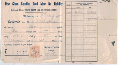 Bendigo Historical Society Inc.
Financial record - Mining documents, 1940-47
... The New Chum Syncline Mine was in Happy Valley Road, West... The New Chum Syncline Mine was in Happy Valley Road, West Bendigo ...The New Chum Syncline Mine was in Happy Valley Road, West BendigoRobinson Fairbairn Collection: New Chum Syncline Gold Mine Shares - 18 in total - all representing 100 shares signed by the Manager Frank Cooper, one of these has a duty stamp attached. New Chum Syncline Gold Mine Forfeiture Notice - for nonpayment of the June Calls in the Golden Sovereign Mine and the New Chum Syncline Gold Mine New Chum Syncline Gold Mine Letter to Shareholder Mrs. S.M. Hosking, acknowledgement of payment for the No 88 Call in the New Chum Syncline Mine, and also to confirm a change of address.history, mining, robinson fairbairn collection, shares, bendigo, new chum syncline mine, golden sovereign mine -
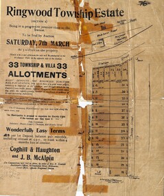 Ringwood and District Historical Society
Flyer, Auction Sale Advertisements - Ringwood Township Estate, Ringwood, Victoria - 1914
... Subdivision includes West Prussia Road (later Wantirna Road... Road Ringwood North melbourne Subdivision includes West Prussia ...Advertisements for auction sale of Ringwood Township Estate (Section A) - Saturday, 7th March (1914), showing subdivision layout, terms of sale, and summary of local features and services. Un-named newspaper clipping advertising this auction also attached.Subdivision includes West Prussia Road (later Wantirna Road), Station Street, and James Street. Agents in conjunction - Coghill & Haughton and J.B. McAlpin. Sale by order of Mrs. E. Kendall. -
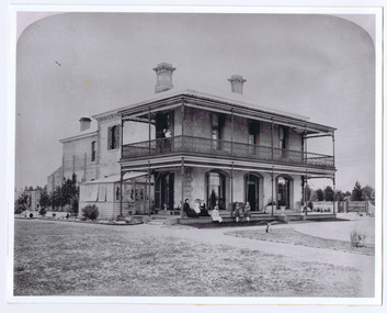 St Kilda Historical Society
Photograph, Donald McDonald, Herford, 1872
... Alma Road south west corner Lansdowne Road built... to this location. Alma Road south west corner Lansdowne Road built ...Large residence on large elevated block for Frederick Christian Lange (1832-1888) and family in 1870. The architect Lloyd Tayler (1830-1900) designed it in an Italianate style. Over time adjoining allotments were purchased until the gardens covered nearly 15 acres. Lange was in partnership with Emil Thoneman trading under the name of Lange & Thoneman, merchants and general importers. Lange was also one of the local directors of the local Australasian directors for the Swiss Lloyd Marine Insurance Company. William Officer (1835-1913), pastoralist, bought the property from Lange in 1888 for 23,500 pounds. Following Officer's death the grounds were subdivided in 1914 and the house finally demolished in 1940. Noting the spelling difference, there is now a street named 'Hertford Street' very close to this location. black and white photograph copyAlma Road south west corner Lansdowne Road built for Federick C Lange (Merchant) Photo 1872 -
 Whitehorse Historical Society Inc.
Photograph, Mullen's House East Burwood
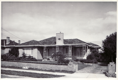
... Burwood 2 houses west of Burwood Road.... at 342 Blackburn Road, East Burwood 2 houses west of Burwood Road ...Black and white photograph of the Mullen's family home, built c1960. It was situated at 342 Blackburn Road, East Burwood 2 houses west of Burwood Road.burwood east, mullen's home c1960 -
Canterbury History Group
Photograph - Canterbury Road looking west along Maling Road
... Canterbury Road looking west along Maling Road...Looking west along Maling Road, photo taken from Canterbury...Looking west along Maling Road, photo taken from Canterbury ...Looking west along Maling Road, photo taken from Canterbury Roadphotograph (proof)canterbury road, maling road, maling road shops -
 Eltham District Historical Society Inc
Photograph, Main Road, Lower Plenty
... looking west from Old Eltham Road... photograph of Main Road, Lower Plenty looking west from Old Eltham ...Black and white photograph of Main Road, Lower Plenty looking west from Old Eltham Roadlower plenty, main road, old eltham road -
 Whitehorse Historical Society Inc.
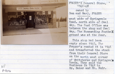
Photograph, Fraser's General Store, C1946-48
... on West side of Springvale Road Nunawading...Whitehorse Historical Society Inc. 2-10 Deep Creek Road ...Black and white photo of Fraser's General Store 1946-48 on West side of Springvale Road Nunawadingfraser, don, marj, colin, beverly -
Canterbury History Group
Photograph - Prospect Hill Road, Canterbury, 1920c
... , near Maling Road, looking west, 1920c..., near Maling Road, looking west, 1920c Photograph Prospect Hill ...Black and white photograph of Prospect Hill Road Canterbury, near Maling Road, looking west, 1920ccanterbury, prospect hill road, roads and streets, houses -
 Ringwood and District Historical Society
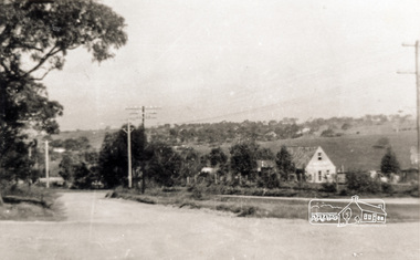
Photograph, Holy Spirit School, North Ringwood, viewed from Jull Road - 1981
... Written on back of photograph, "E620. 1981. Looking west..., "E620. 1981. Looking west from Jull Road. North Ringwood at Holy ...Written on back of photograph, "E620. 1981. Looking west from Jull Road. North Ringwood at Holy Spirit School".