Showing 39 items
matching william mudge
-
 Ballarat Heritage Services
Photograph - Colour, Entrance to Public toilets hidden in earth mound, Old Sarum, England, English Heritage Site, 2016, 01 November 2016
... ordnance survey, william mudge, jesse ramsden, william the... Lieutenant William Mudge laid out a base-line 36,574 feet (11,253... below Old Sarum Lieutenant William Mudge laid out a base-line ...William the Conqueror inherited Old Sarum from the last Saxon king of England. It was an ideal site for a royal castle. It was here in 1070 that William paid off his army after a long and bitter campaign in northern England. It was here in 1086 that he called together all the major landholders in England so they could swear allegiance to him. It was a crucial moment. The Domesday Book was being written, a threatened Viking invasion had only just been averted and William's eldest son was in armed rebellion. Old Sarum was an important place where this Norman king of England held power. In 1794 the Ordnance Survey set out to check the accuracy of the first mapping of Southern England, which had begun ten years earlier. From a point just below Old Sarum Lieutenant William Mudge laid out a base-line 36,574 feet (11,253 metres) long. From each end of the line the positions of distant places were plotted using a huge theodolite made in 1791 by Jesse Ramsden. The accuracy of the process, which was repeated all over England, depended on Jesse Ramsden's craftsmanship and on William Mudge's surveying skill in setting out this first base-line from Old Sarum. The nearer end of Mudge's line is marked by an inscribed stone beside the modern A345 at Old Sarum. ordnance survey, william mudge, jesse ramsden, william the conqueror, old sarum, saxon, 1086, england -
 Ballarat Heritage Services
Photograph - Colour, Masons' Marks, Old Sarum, England, English Heritage Site, 2016, 01 November 2016
... ordnance survey, william mudge, jesse ramsden, william the... Lieutenant William Mudge laid out a base-line 36,574 feet (11,253... below Old Sarum Lieutenant William Mudge laid out a base-line ...William the Conqueror inherited Old Sarum from the last Saxon king of England. It was an ideal site for a royal castle. It was here in 1070 that William paid off his army after a long and bitter campaign in northern England. It was here in 1086 that he called together all the major landholders in England so they could swear allegiance to him. It was a crucial moment. The Domesday Book was being written, a threatened Viking invasion had only just been averted and William's eldest son was in armed rebellion. Old Sarum was an important place where this Norman king of England held power. In 1794 the Ordnance Survey set out to check the accuracy of the first mapping of Southern England, which had begun ten years earlier. From a point just below Old Sarum Lieutenant William Mudge laid out a base-line 36,574 feet (11,253 metres) long. From each end of the line the positions of distant places were plotted using a huge theodolite made in 1791 by Jesse Ramsden. The accuracy of the process, which was repeated all over England, depended on Jesse Ramsden's craftsmanship and on William Mudge's surveying skill in setting out this first base-line from Old Sarum. The nearer end of Mudge's line is marked by an inscribed stone beside the modern A345 at Old Sarum. ordnance survey, william mudge, jesse ramsden, william the conqueror, old sarum, saxon, 1086, england -
 Ballarat Heritage Services
Photograph - Colour, Masons' Marks, Old Sarum, England, English Heritage Site, 01 November 2016
... ordnance survey, william mudge, jesse ramsden, william the... Lieutenant William Mudge laid out a base-line 36,574 feet (11,253... below Old Sarum Lieutenant William Mudge laid out a base-line ...William the Conqueror inherited Old Sarum from the last Saxon king of England. It was an ideal site for a royal castle. It was here in 1070 that William paid off his army after a long and bitter campaign in northern England. It was here in 1086 that he called together all the major landholders in England so they could swear allegiance to him. It was a crucial moment. The Domesday Book was being written, a threatened Viking invasion had only just been averted and William's eldest son was in armed rebellion. Old Sarum was an important place where this Norman king of England held power. In 1794 the Ordnance Survey set out to check the accuracy of the first mapping of Southern England, which had begun ten years earlier. From a point just below Old Sarum Lieutenant William Mudge laid out a base-line 36,574 feet (11,253 metres) long. From each end of the line the positions of distant places were plotted using a huge theodolite made in 1791 by Jesse Ramsden. The accuracy of the process, which was repeated all over England, depended on Jesse Ramsden's craftsmanship and on William Mudge's surveying skill in setting out this first base-line from Old Sarum. The nearer end of Mudge's line is marked by an inscribed stone beside the modern A345 at Old Sarum. ordnance survey, william mudge, jesse ramsden, william the conqueror, old sarum, saxon, 1086, england -
 Ballarat Heritage Services
Photograph - Colour, Masons' Marks, Old Sarum, England, English Heritage Site, 2016, 01 November 2016
... ordnance survey, william mudge, jesse ramsden, william the... Lieutenant William Mudge laid out a base-line 36,574 feet (11,253... below Old Sarum Lieutenant William Mudge laid out a base-line ...William the Conqueror inherited Old Sarum from the last Saxon king of England. It was an ideal site for a royal castle. It was here in 1070 that William paid off his army after a long and bitter campaign in northern England. It was here in 1086 that he called together all the major landholders in England so they could swear allegiance to him. It was a crucial moment. The Domesday Book was being written, a threatened Viking invasion had only just been averted and William's eldest son was in armed rebellion. Old Sarum was an important place where this Norman king of England held power. In 1794 the Ordnance Survey set out to check the accuracy of the first mapping of Southern England, which had begun ten years earlier. From a point just below Old Sarum Lieutenant William Mudge laid out a base-line 36,574 feet (11,253 metres) long. From each end of the line the positions of distant places were plotted using a huge theodolite made in 1791 by Jesse Ramsden. The accuracy of the process, which was repeated all over England, depended on Jesse Ramsden's craftsmanship and on William Mudge's surveying skill in setting out this first base-line from Old Sarum. The nearer end of Mudge's line is marked by an inscribed stone beside the modern A345 at Old Sarum. ordnance survey, william mudge, jesse ramsden, william the conqueror, old sarum, saxon, 1086, england -
 Ballarat Heritage Services
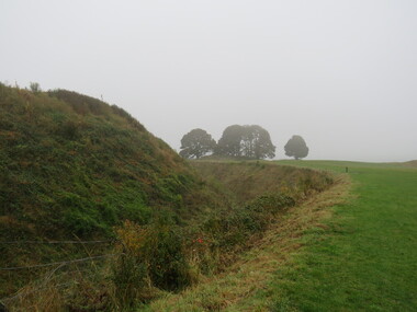
Photograph - Photograph - Colour, Earth Banks, Old Sarum, England, 01 November 2016
... william mudge... Lieutenant William Mudge laid out a base-line 36,574 feet (11,253... Lieutenant William Mudge laid out a base-line 36,574 feet (11,253 ...William the Conqueror inherited Old Sarum from the last Saxon king of England. It was an ideal site for a royal castle. It was here in 1070 that William paid off his army after a long and bitter campaign in northern England. It was here in 1086 that he called together all the major landholders in England so they could swear allegiance to him. It was a crucial moment. The Domesday Book was being written, a threatened Viking invasion had only just been averted and William's eldest son was in armed rebellion. Old Sarum was an important place where this Norman king of England held power. In 1794 the Ordnance Survey set out to check the accuracy of the first mapping of Southern England, which had begun ten years earlier. From a point just below Old Sarum Lieutenant William Mudge laid out a base-line 36,574 feet (11,253 metres) long. From each end of the line the positions of distant places were plotted using a huge theodolite made in 1791 by Jesse Ramsden. The accuracy of the process, which was repeated all over England, depended on Jesse Ramsden's craftsmanship and on William Mudge's surveying skill in setting out this first base-line from Old Sarum. The nearer end of Mudge's line is marked by an inscribed stone beside the modern A345 at Old Sarum. Colour photograph of Earth Banks, Old Sarum, Englandordnance survey, william mudge, jesse ramsden, william the conqueror, old sarum, saxon, 1086, england -
 Federation University Historical Collection
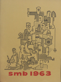
Booklet, Ballarat School of Mines Students' Magazine, 1963, 1963
Ballarat School of Mines Students' Magazine, 1963. Editorial, Prominent Personalities, King Island - Vacation Wonderland, Look back in Wonder, The Sensible Enemy, Diploma Conferring Ceremony, R. W. Richards Medal, Diplomas Conferred, Personality Tests and the Individual, Poison to Poison - Students' Revue for 1963, Malaya, Income Tax, Rustling Rags, Where Mankind has Failed, Sports Awards 1963, Sports, School Council, Members of Staff, Roll Call Yellow soft cover with red inscriptions and black figures on front cover, 104 pages including advertisements.ballarat school of mines students' magazine 1963, staff, sports, tony brauer, bob coutts, paul pusari, jeni milbourne, kerry penna brian mclennan, bob grub, john davis, netta walta, kevin brady, oscar rogers, kuo yiew see, h. e. arblaster, stanley white, quentin reynolds smyth, l. p. coombes - chief superintendent aeronautical research laboratories melbourne, graeme george redman, robert skewes, chookiat tanaksaranond, alan james bethune, lachlan stewart campbell, graham william hall, john rash, alan kenneth webb, peter agrums, sr. mary chanel fitzsimmons, david ewan clarke kirton, william joseph lannen, neil frances menz, keith houston alexander, john alexander pollock, john peter russell, francis william hunting, chookiate sirivongse, chong thung tay, keith stanley waller, bryan magson, anne moorehouse, stephen drew, gerry liston, gary roberts, ray megee, peter smith, daila berzins, don yates, kelvin whitford, greg hunter, david bell, michael moissinac, neil mudge, arthur patterson, edward scull, joseph heller, g. roberts, j. humphreys, bobby ong, alan cox, p. l. day, r. coutts, wayne johnson, prasert mahattanakul, l. t. negri, ooi kok hai, photography