Showing 152 items
matching woodridge estate
-
 Eltham District Historical Society Inc
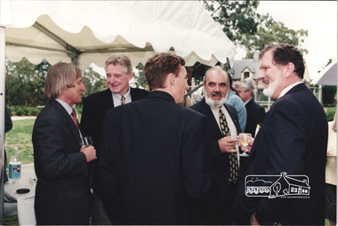
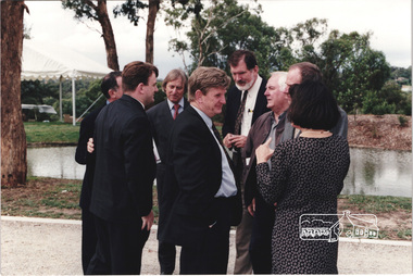
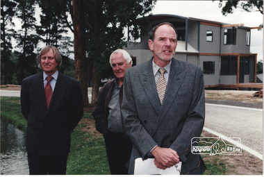
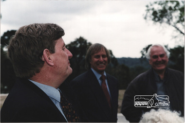
Photograph, Nillumbik Shire President Robert Marshall (left), Planning Minister Rob Maclellan (centre back to camera) and Cr. John Graves (right) at the launch of the Kinloch Gardens development, 93 Arthur Street, Eltham, April 1998, April 1998
... , woodridge estate... marshall, woodridge estate 1 images; digital file only; created ...Launch of the Kinloch Gardens development, 12 new double and triple storey homes along a private road in the gardens of Kinloch, a mansion set on 2.4ha in Arthur St. The launch was attended by Planning Minister Rob Maclellan and Nillumbik Shire president Robert Marshall, Architects Graeme Gunn and Ian Jelbart and approximately 100 guests.1 images; digital file only; created from scan undertaken by EDHS of a set of 26 colour 10 x 15 cm prints arthur street, eltham, houses, jelbart property, john graves, kinloch gardens, rob maclellan, robert marshall, woodridge estate -
 Eltham District Historical Society Inc
Photograph, Tom Higginbottom (left) at the launch of the Kinloch Gardens development, 93 Arthur Street, Eltham, April 1998, April 1998
... graves, kinloch gardens, woodridge estate... property, john graves, kinloch gardens, woodridge estate 15 images ...Launch of the Kinloch Gardens development, 12 new double and triple storey homes along a private road in the gardens of Kinloch, a mansion set on 2.4ha in Arthur St. The launch was attended by Planning Minister Rob Maclellan and Nillumbik Shire president Robert Marshall, Architects Graeme Gunn and Ian Jelbart and approximately 100 guests.15 images; digital file only; created from scan undertaken by EDHS of a set of 29 colour 10 x 15 cm prints arthur street, eltham, houses, jelbart property, john graves, kinloch gardens, woodridge estate -
 Eltham District Historical Society Inc
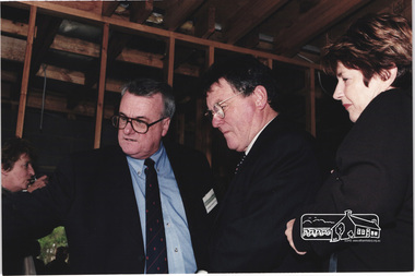
Photograph, In front of the Barn at the launch of the Kinloch Gardens development, 93 Arthur Street, Eltham, April 1998, Cr. John Graves at rear, April 1998
... graves, kinloch gardens, the barn, woodridge estate... property, john graves, kinloch gardens, the barn, woodridge estate ...Launch of the Kinloch Gardens development, 12 new double and triple storey homes along a private road in the gardens of Kinloch, a mansion set on 2.4ha in Arthur St. The launch was attended by Planning Minister Rob Maclellan and Nillumbik Shire president Robert Marshall, Architects Graeme Gunn and Ian Jelbart and approximately 100 guests.1 images; digital file only; created from scan undertaken by EDHS of a set of 29 colour 10 x 15 cm prints arthur street, eltham, houses, jelbart property, john graves, kinloch gardens, the barn, woodridge estate -
 Eltham District Historical Society Inc
Photograph, Robert Marshall (left) with Jenny and John Graves at the launch of the Kinloch Gardens development, 93 Arthur Street, Eltham, April 1998, April 1998
... graves, john graves, kinloch gardens, robert marshall, woodridge... marshall, woodridge estate 2 images; digital file only; created ...Launch of the Kinloch Gardens development, 12 new double and triple storey homes along a private road in the gardens of Kinloch, a mansion set on 2.4ha in Arthur St. The launch was attended by Planning Minister Rob Maclellan and Nillumbik Shire president Robert Marshall, Architects Graeme Gunn and Ian Jelbart and approximately 100 guests.2 images; digital file only; created from scan undertaken by EDHS of a set of 29 colour 10 x 15 cm prints arthur street, eltham, houses, jelbart property, jenny graves, john graves, kinloch gardens, robert marshall, woodridge estate -
 Eltham District Historical Society Inc
Photograph, Robert Marshall with Graeme Gunn chatting to John and Jenny Graves (front right) at the launch of the Kinloch Gardens development, 93 Arthur Street, Eltham, April 1998, April 1998
... marshall, woodridge estate..., robert marshall, woodridge estate 3 images; digital file only ...Launch of the Kinloch Gardens development, 12 new double and triple storey homes along a private road in the gardens of Kinloch, a mansion set on 2.4ha in Arthur St. The launch was attended by Planning Minister Rob Maclellan and Nillumbik Shire president Robert Marshall, Architects Graeme Gunn and Ian Jelbart and approximately 100 guests.3 images; digital file only; created from scan undertaken by EDHS of a set of 29 colour 10 x 15 cm prints arthur street, eltham, graeme gunn, houses, jelbart property, jenny graves, john graves, kinloch gardens, robert marshall, woodridge estate -
 Eltham District Historical Society Inc
Photograph, Architect Ian Jelbart (centre) with Elders Real Estate agents at the launch of the Kinloch Gardens development, 93 Arthur Street, Eltham, April 1998, April 1998
... jelbart, jelbart property, kinloch gardens, woodridge estate... and approximately 100 guests. arthur street, elders real estate, eltham ...Launch of the Kinloch Gardens development, 12 new double and triple storey homes along a private road in the gardens of Kinloch, a mansion set on 2.4ha in Arthur St. The launch was attended by Planning Minister Rob Maclellan and Nillumbik Shire president Robert Marshall, Architects Graeme Gunn and Ian Jelbart and approximately 100 guests.1 images; digital file only; created from scan undertaken by EDHS of a set of 29 colour 10 x 15 cm prints arthur street, elders real estate, eltham, houses, ian jelbart, jelbart property, kinloch gardens, woodridge estate -
 Eltham District Historical Society Inc
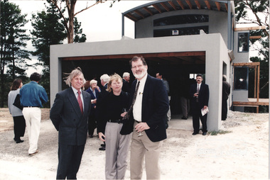
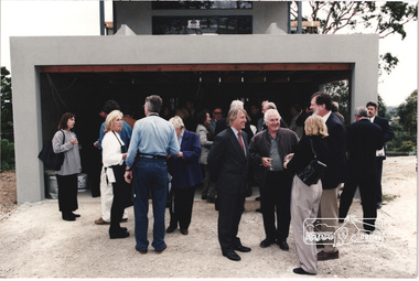
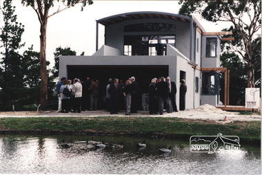
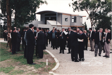
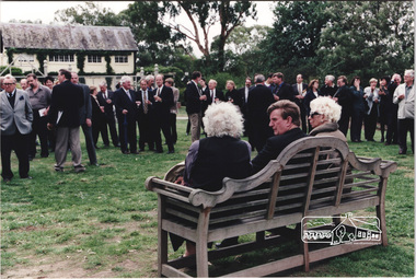
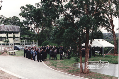
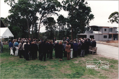
Photograph, Launch of the Kinloch Gardens development, 93 Arthur Street, Eltham, April 1998, April 1998
... Woodridge Estate... Street Jelbart property Kinloch Woodridge Estate 7 images ...Brand new home under construction by Vizarje Homes, Greensborough at the launch of the Kinloch Gardens development, 12 new double and triple storey homes along a private road in the gardens of Kinloch, a mansion set on 2.4ha in Arthur St. The launch was attended by Planning Minister Rob Maclellan and Nillumbik Shire president Robert Marshall, Architects Graeme Gunn and Ian Jelbart and approximately 100 guests.7 images; digital file only; created from scan undertaken by EDHS of a set of 29 colour 10 x 15 cm prints vizarje homes, arthur street, jelbart property, kinloch, woodridge estate -
 Eltham District Historical Society Inc
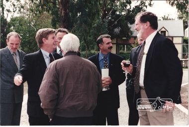
Photograph, L-R: Architect Ian Jelbart, Planning Minister Rob Maclellan, Elders agent (at rear), Architect Graeme Gunn (back to camera), Wayne Phillips, John Graves at the launch of the Kinloch Gardens development, 93 Arthur Street, Eltham, April 1998, April 1998
... , rob maclellan, wayne phillips, woodridge estate..., planning minister, rob maclellan, wayne phillips, woodridge estate ...Launch of the Kinloch Gardens development, 12 new double and triple storey homes along a private road in the gardens of Kinloch, a mansion set on 2.4ha in Arthur St. The launch was attended by Planning Minister Rob Maclellan and Nillumbik Shire president Robert Marshall, Architects Graeme Gunn and Ian Jelbart and approximately 100 guests.1 images; digital file only; created from scan undertaken by EDHS of a set of 34 colour 10 x 15 cm prints arthur street, eltham, graeme gunn, houses, ian jelbart, jelbart property, john graves, kinloch gardens, planning minister, rob maclellan, wayne phillips, woodridge estate -
 Eltham District Historical Society Inc
Photograph, L-R: Wayne Phillips, unknown , Robert Marshall, Rob Maclellan, John Graves, Graeme Gunn, Ian and Christine Jelbart at the launch of the Kinloch Gardens development, 93 Arthur Street, Eltham, April 1998, April 1998
... phillips, woodridge estate..., wayne phillips, woodridge estate 1 images; digital file only ...Launch of the Kinloch Gardens development, 12 new double and triple storey homes along a private road in the gardens of Kinloch, a mansion set on 2.4ha in Arthur St. The launch was attended by Planning Minister Rob Maclellan and Nillumbik Shire president Robert Marshall, Architects Graeme Gunn and Ian Jelbart and approximately 100 guests.1 images; digital file only; created from scan undertaken by EDHS of a set of 34 colour 10 x 15 cm prints arthur street, christine jelbart, eltham, graeme gunn, houses, ian jelbart, jelbart property, john graves, kinloch gardens, planning minister, rob maclellan, robert marshall, wayne phillips, woodridge estate -
 Eltham District Historical Society Inc
Photograph, Sigmund Jorgensen in centre middle at the launch of the Kinloch Gardens development, 93 Arthur Street, Eltham, April 1998, April 1998
... , robert marshall, sigmund jorgensen, wayne phillips, woodridge... phillips, woodridge estate 3 images; digital file only; created ...Launch of the Kinloch Gardens development, 12 new double and triple storey homes along a private road in the gardens of Kinloch, a mansion set on 2.4ha in Arthur St. The launch was attended by Planning Minister Rob Maclellan and Nillumbik Shire president Robert Marshall, Architects Graeme Gunn and Ian Jelbart and approximately 100 guests.3 images; digital file only; created from scan undertaken by EDHS of a set of 34 colour 10 x 15 cm prints arthur street, eltham, graeme gunn, houses, ian jelbart, jelbart property, john graves, kinloch gardens, rob maclellan, robert marshall, sigmund jorgensen, wayne phillips, woodridge estate -
 Eltham District Historical Society Inc
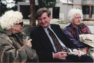
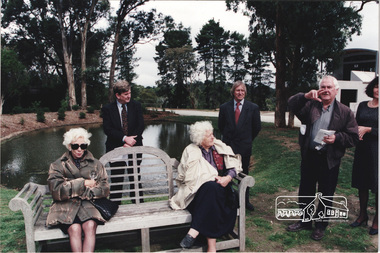
Photograph, Planning Minister Rob Maclellan with two unknown women at the launch of the Kinloch Gardens development, 93 Arthur Street, Eltham, April 1998, April 1998
... gardens, rob maclellan, woodridge estate... property, kinloch gardens, rob maclellan, woodridge estate 4 images ...Launch of the Kinloch Gardens development, 12 new double and triple storey homes along a private road in the gardens of Kinloch, a mansion set on 2.4ha in Arthur St. The launch was attended by Planning Minister Rob Maclellan and Nillumbik Shire president Robert Marshall, Architects Graeme Gunn and Ian Jelbart and approximately 100 guests.4 images; digital file only; created from scan undertaken by EDHS of a set of 34 colour 10 x 15 cm prints arthur street, eltham, houses, jelbart property, kinloch gardens, rob maclellan, woodridge estate -
 Eltham District Historical Society Inc
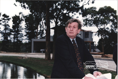
Photograph, Planning Minister Rob Maclellan at the launch of the Kinloch Gardens development, 93 Arthur Street, Eltham, April 1998, April 1998
... graves, kinloch gardens, rob maclellan, woodridge estate... property, john graves, kinloch gardens, rob maclellan, woodridge ...Launch of the Kinloch Gardens development, 12 new double and triple storey homes along a private road in the gardens of Kinloch, a mansion set on 2.4ha in Arthur St. The launch was attended by Planning Minister Rob Maclellan and Nillumbik Shire president Robert Marshall, Architects Graeme Gunn and Ian Jelbart and approximately 100 guests.4 images; digital file only; created from scan undertaken by EDHS of a set of 34 colour 10 x 15 cm prints arthur street, eltham, houses, jelbart property, john graves, kinloch gardens, rob maclellan, woodridge estate -
 Eltham District Historical Society Inc
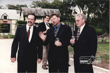
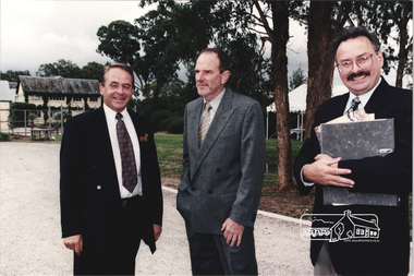
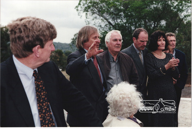
Photograph, Standing L-R: Planning Minister Rob Maclellan, Shire President Robert Marshall and Architect Graeme Gunn at the launch of the Kinloch Gardens development, 93 Arthur Street, Eltham, April 1998, April 1998
... maclellan, robert marshall, woodridge estate... gardens, rob maclellan, robert marshall, woodridge estate 3 images ...Launch of the Kinloch Gardens development, 12 new double and triple storey homes along a private road in the gardens of Kinloch, a mansion set on 2.4ha in Arthur St. The launch was attended by Planning Minister Rob Maclellan and Nillumbik Shire president Robert Marshall, Architects Graeme Gunn and Ian Jelbart and approximately 100 guests.3 images; digital file only; created from scan undertaken by EDHS of a set of 34 colour 10 x 15 cm prints arthur street, christine jelbart, eltham, graeme gunn, houses, ian jelbart, jelbart property, kinloch gardens, rob maclellan, robert marshall, woodridge estate -
 Eltham District Historical Society Inc
Photograph, Standing L-R: Nillumbik Shire President Robert Marshall, Architect Graeme Gunn and owners Architect Ian Jelbart and his wife, Christine Jelbart at the launch of the Kinloch Gardens development, 93 Arthur Street, Eltham, April 1998, April 1998
... marshall, woodridge estate... gardens, robert marshall, woodridge estate 1 images; digital file ...Launch of the Kinloch Gardens development, 12 new double and triple storey homes along a private road in the gardens of Kinloch, a mansion set on 2.4ha in Arthur St. The launch was attended by Planning Minister Rob Maclellan and Nillumbik Shire president Robert Marshall, Architects Graeme Gunn and Ian Jelbart and approximately 100 guests.1 images; digital file only; created from scan undertaken by EDHS of a set of 34 colour 10 x 15 cm prints arthur street, christine jelbart, eltham, graeme gunn, houses, ian jelbart, jelbart property, kinloch gardens, robert marshall, woodridge estate -
 Eltham District Historical Society Inc
Photograph, At the launch of the Kinloch Gardens development, 93 Arthur Street, Eltham, April 1998, April 1998
... gardens, woodridge estate... property, kinloch gardens, woodridge estate 2 images; digital file ...Launch of the Kinloch Gardens development, 12 new double and triple storey homes along a private road in the gardens of Kinloch, a mansion set on 2.4ha in Arthur St. The launch was attended by Planning Minister Rob Maclellan and Nillumbik Shire president Robert Marshall, Architects Graeme Gunn and Ian Jelbart and approximately 100 guests.2 images; digital file only; created from scan undertaken by EDHS of a set of 34 colour 10 x 15 cm prints arthur street, eltham, houses, jelbart property, kinloch gardens, woodridge estate -
 Eltham District Historical Society Inc
Photograph, Standing L-R: Nillumbik Shire President Robert Marshall, Architect Graeme Gunn and owners Architect Ian Jelbart and his wife, Christine Jelbart at the launch of the Kinloch Gardens development, 93 Arthur Street, Eltham, April 1998, April 1998
... marshall, woodridge estate... gardens, robert marshall, woodridge estate 1 images; digital file ...Launch of the Kinloch Gardens development, 12 new double and triple storey homes along a private road in the gardens of Kinloch, a mansion set on 2.4ha in Arthur St. The launch was attended by Planning Minister Rob Maclellan and Nillumbik Shire president Robert Marshall, Architects Graeme Gunn and Ian Jelbart and approximately 100 guests.1 images; digital file only; created from scan undertaken by EDHS of a set of 34 colour 10 x 15 cm prints arthur street, christine jelbart, eltham, graeme gunn, houses, ian jelbart, jelbart property, kinloch gardens, robert marshall, woodridge estate -
 Eltham District Historical Society Inc
Photograph, Standing L-R: Planning Minister Rob Maclellan, Shire President Robert Marshall, Architect Graeme Gunn and owners Architect Ian Jelbart and his wife, Christine Jelbart and unk. at the launch of the Kinloch Gardens development, 93 Arthur Street, Eltham, April 1998, April 1998
... maclellan, robert marshall, woodridge estate... gardens, rob maclellan, robert marshall, woodridge estate 3 images ...Launch of the Kinloch Gardens development, 12 new double and triple storey homes along a private road in the gardens of Kinloch, a mansion set on 2.4ha in Arthur St. The launch was attended by Planning Minister Rob Maclellan and Nillumbik Shire president Robert Marshall, Architects Graeme Gunn and Ian Jelbart and approximately 100 guests.3 images; digital file only; created from scan undertaken by EDHS of a set of 34 colour 10 x 15 cm prints arthur street, christine jelbart, eltham, graeme gunn, houses, ian jelbart, jelbart property, kinloch gardens, rob maclellan, robert marshall, woodridge estate -
 Eltham District Historical Society Inc
Photograph, Standing L-R: Nillumbik Shire President Robert Marshall, Architect Graeme Gunn and owners Architect Ian Jelbart and his wife, Christine Jelbart at the launch of the Kinloch Gardens development, 93 Arthur Street, Eltham, April 1998, April 1998
... marshall, woodridge estate... gardens, robert marshall, woodridge estate 1 images; digital file ...Launch of the Kinloch Gardens development, 12 new double and triple storey homes along a private road in the gardens of Kinloch, a mansion set on 2.4ha in Arthur St. The launch was attended by Planning Minister Rob Maclellan and Nillumbik Shire president Robert Marshall, Architects Graeme Gunn and Ian Jelbart and approximately 100 guests.1 images; digital file only; created from scan undertaken by EDHS of a set of 34 colour 10 x 15 cm prints arthur street, christine jelbart, eltham, graeme gunn, houses, ian jelbart, jelbart property, kinloch gardens, robert marshall, woodridge estate -
 Eltham District Historical Society Inc
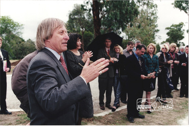
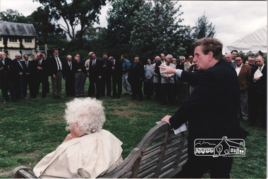
Photograph, Nillumbik Shire President Robert Marshall addressing the guests at the launch of the Kinloch Gardens development, 93 Arthur Street, Eltham, April 1998, April 1998
... maclellan*, robert marshall, wayne phillips, woodridge estate..., woodridge estate 4 images; digital file only; created from scan ...Launch of the Kinloch Gardens development, 12 new double and triple storey homes along a private road in the gardens of Kinloch, a mansion set on 2.4ha in Arthur St. The launch was attended by Planning Minister Rob Maclellan and Nillumbik Shire president Robert Marshall, Architects Graeme Gunn and Ian Jelbart and approximately 100 guests.4 images; digital file only; created from scan undertaken by EDHS of a set of 34 colour 10 x 15 cm prints arthur street, christine jelbart, eltham, graeme gunn, houses, ian jelbart*, jelbart property, kinloch gardens, rob maclellan*, robert marshall, wayne phillips, woodridge estate -
 Eltham District Historical Society Inc
Photograph, Standing L-R: Nillumbik Shire President Robert Marshall, Architect Graeme Gunn and owners Architect Ian Jelbart and his wife, Christine Jelbart at the launch of the Kinloch Gardens development, 93 Arthur Street, Eltham, April 1998, April 1998
... marshall, woodridge estate... gardens, robert marshall, woodridge estate 1 images; digital file ...Launch of the Kinloch Gardens development, 12 new double and triple storey homes along a private road in the gardens of Kinloch, a mansion set on 2.4ha in Arthur St. The launch was attended by Planning Minister Rob Maclellan and Nillumbik Shire president Robert Marshall, Architects Graeme Gunn and Ian Jelbart and approximately 100 guests.1 images; digital file only; created from scan undertaken by EDHS of a set of 34 colour 10 x 15 cm prints arthur street, christine jelbart, eltham, graeme gunn, houses, ian jelbart, jelbart property, kinloch gardens, robert marshall, woodridge estate -
 Eltham District Historical Society Inc
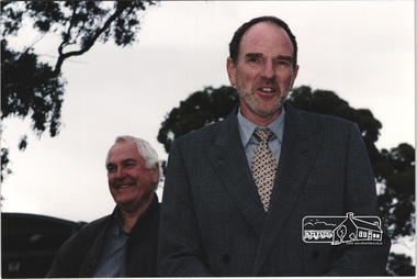
Photograph, Planning Minister Rob Maclellan addressing the guests at the launch of the Kinloch Gardens development, 93 Arthur Street, Eltham, April 1998, April 1998
... gardens, rob maclellan, woodridge estate... property, kinloch gardens, rob maclellan, woodridge estate 2 images ...Launch of the Kinloch Gardens development, 12 new double and triple storey homes along a private road in the gardens of Kinloch, a mansion set on 2.4ha in Arthur St. The launch was attended by Planning Minister Rob Maclellan and Nillumbik Shire president Robert Marshall, Architects Graeme Gunn and Ian Jelbart and approximately 100 guests.2 images; digital file only; created from scan undertaken by EDHS of a set of 34 colour 10 x 15 cm prints arthur street, eltham, houses, jelbart property, kinloch gardens, rob maclellan, woodridge estate -
 Eltham District Historical Society Inc
Photograph, Standing L-R: Nillumbik Shire President Robert Marshall, Architect Graeme Gunn and owner Architect Ian Jelbart addressing the guests at the launch of the Kinloch Gardens development, 93 Arthur Street, Eltham, April 1998, April 1998
... , jelbart property, kinloch gardens, robert marshall, woodridge... marshall, woodridge estate 3 images; digital file only; created ...Launch of the Kinloch Gardens development, 12 new double and triple storey homes along a private road in the gardens of Kinloch, a mansion set on 2.4ha in Arthur St. The launch was attended by Planning Minister Rob Maclellan and Nillumbik Shire president Robert Marshall, Architects Graeme Gunn and Ian Jelbart and approximately 100 guests.3 images; digital file only; created from scan undertaken by EDHS of a set of 34 colour 10 x 15 cm prints arthur street, eltham, graeme gunn, houses, ian jelbart, jelbart property, kinloch gardens, robert marshall, woodridge estate -
 Eltham District Historical Society Inc
Photograph, Owner and Architect Ian Jelbart addressing the guests at the launch of the Kinloch Gardens development, 93 Arthur Street, Eltham, April 1998, April 1998
... , robert marshall, woodridge estate..., kinloch gardens, robert marshall, woodridge estate 8 images ...Launch of the Kinloch Gardens development, 12 new double and triple storey homes along a private road in the gardens of Kinloch, a mansion set on 2.4ha in Arthur St. The launch was attended by Planning Minister Rob Maclellan and Nillumbik Shire president Robert Marshall, Architects Graeme Gunn and Ian Jelbart and approximately 100 guests.8 images; digital file only; created from scan undertaken by EDHS of a set of 30 colour 10 x 15 cm prints arthur street, eltham, graeme gunn, houses, ian jelbart, jelbart property, jenny graves, john graves, kinloch gardens, robert marshall, woodridge estate -
 Eltham District Historical Society Inc
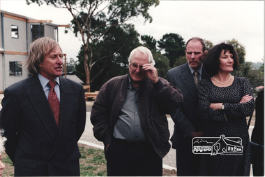
Photograph, Standing L-R: Planning Minister Rob Maclellan, Nillumbik Shire President Robert Marshall, Architect Graeme Gunn and owner and Architect Ian Jelbart at the launch of the Kinloch Gardens development, 93 Arthur Street, Eltham, April 1998, April 1998
... , woodridge estate..., robert marshall, woodridge estate 2 images; digital file only ...Launch of the Kinloch Gardens development, 12 new double and triple storey homes along a private road in the gardens of Kinloch, a mansion set on 2.4ha in Arthur St. The launch was attended by Planning Minister Rob Maclellan and Nillumbik Shire president Robert Marshall, Architects Graeme Gunn and Ian Jelbart and approximately 100 guests.2 images; digital file only; created from scan undertaken by EDHS of a set of 30 colour 10 x 15 cm prints arthur street, eltham, graeme gunn, houses, ian jelbart, jelbart property, kinloch gardens, rob maclellan, robert marshall, woodridge estate -
 Eltham District Historical Society Inc
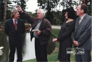
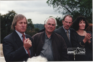
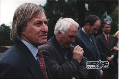
Photograph, Planning Minister Rob Maclellan with Nillumbik Shire President Robert Marshall and Architect Graeme Gunn at rear at the launch of the Kinloch Gardens development, 93 Arthur Street, Eltham, April 1998, April 1998
... , woodridge estate..., woodridge estate 4 images; digital file only; created from scan ...Launch of the Kinloch Gardens development, 12 new double and triple storey homes along a private road in the gardens of Kinloch, a mansion set on 2.4ha in Arthur St. The launch was attended by Planning Minister Rob Maclellan and Nillumbik Shire president Robert Marshall, Architects Graeme Gunn and Ian Jelbart and approximately 100 guests.4 images; digital file only; created from scan undertaken by EDHS of a set of 30 colour 10 x 15 cm prints arthur street, eltham, graeme gunn, houses, jelbart property, kinloch gardens, rob maclellan, robert marshall, woodridge estate -
 Eltham District Historical Society Inc
Photograph, Planning Minister Rob Maclellan at the launch of the Kinloch Gardens development, 93 Arthur Street, Eltham, April 1998, April 1998
... gardens, rob maclellan, woodridge estate... property, kinloch gardens, rob maclellan, woodridge estate 5 images ...Launch of the Kinloch Gardens development, 12 new double and triple storey homes along a private road in the gardens of Kinloch, a mansion set on 2.4ha in Arthur St. The launch was attended by Planning Minister Rob Maclellan and Nillumbik Shire president Robert Marshall, Architects Graeme Gunn and Ian Jelbart and approximately 100 guests.5 images; digital file only; created from scan undertaken by EDHS of a set of 30 colour 10 x 15 cm prints arthur street, eltham, houses, jelbart property, kinloch gardens, rob maclellan, woodridge estate -
 Eltham District Historical Society Inc
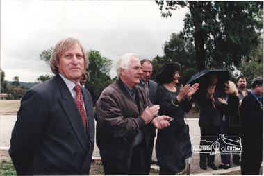
Photograph, L-R: Nillumbik Shire President Robert Marshall with architects Graeme Gunn and Ian Jelbart at the launch of the Kinloch Gardens development, 93 Arthur Street, Eltham, April 1998, April 1998
... , jelbart property, kinloch gardens, robert marshall, woodridge... marshall, woodridge estate 3 images; digital file only; created ...Launch of the Kinloch Gardens development, 12 new double and triple storey homes along a private road in the gardens of Kinloch, a mansion set on 2.4ha in Arthur St. The launch was attended by Planning Minister Rob Maclellan and Nillumbik Shire president Robert Marshall, Architects Graeme Gunn and Ian Jelbart and approximately 100 guests.3 images; digital file only; created from scan undertaken by EDHS of a set of 30 colour 10 x 15 cm prints arthur street, eltham, graeme gunn, houses, ian jelbart, jelbart property, kinloch gardens, robert marshall, woodridge estate -
 Eltham District Historical Society Inc
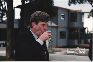
Photograph, Planning Minister Rob Maclellan at the launch of the Kinloch Gardens development, 93 Arthur Street, Eltham, April 1998, April 1998
... gardens, rob maclellan, woodridge estate... property, kinloch gardens, rob maclellan, woodridge estate ...Launch of the Kinloch Gardens development, 12 new double and triple storey homes along a private road in the gardens of Kinloch, a mansion set on 2.4ha in Arthur St. The launch was attended by Planning Minister Rob Maclellan and Nillumbik Shire president Robert Marshall, Architects Graeme Gunn and Ian Jelbart and approximately 100 guests.1 images; digital file only; created from scan undertaken by EDHS of a set of 30 colour 10 x 15 cm prints arthur street, eltham, houses, jelbart property, kinloch gardens, rob maclellan, woodridge estate, celebration, wine, drinking -
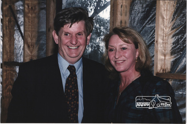 Eltham District Historical Society Inc
Photograph, Planning Minister Rob Maclellan with unknown woman at the launch of the Kinloch Gardens development, Eltham, April 1998
... gardens, rob maclellan, woodridge estate... property, kinloch gardens, rob maclellan, woodridge estate 1 images ...Planning Minister Rob Maclellan at the launch of the Kinloch Gardens development, 12 new double and triple storey homes along a private road in the gardens of Kinloch, a mansion set on 2.4ha in 93 Arthur St. The launch was attended by Planning Minister Rob Maclellan and Nillumbik Shire president Robert Marshall, Architects Graeme Gunn and Ian Jelbart and approximately 100 guests. April 19981 images; digital file only; created from scan undertaken by EDHS of a set of 30 colour 10 x 15 cm prints arthur street, eltham, houses, jelbart property, kinloch gardens, rob maclellan, woodridge estate