Showing 2565 items
matching aerial
-
 Eltham District Historical Society Inc
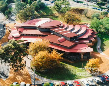
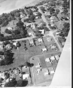
Photo album, Aerial view showing the new Eltham Library, 1994, 1994
Library Development The library building has been designed to reflect its parkland setting. External features include: the roof which includes interesting aspects when viewed from Main Road; verandahs which provide ramp access and give a sheltered entrance to the building; walls which feature locally-made mudbricks, conventional bricks and copper panels; and space for an outdoor courtyard/reading area which will be developed later. Internally there are a number of features. The building includes a foyer with a fireplace suitable for displays including artwork; a community multi-purpose room suitable for meetings or functions and an outdoor cafeteria. The ceilings are lined with Victorian Ash. The shapes for the ceiling give a free flowing form to the building. Brush Box has been used for the circulation and information desks. The tree trunk columns are Grey lronbark from New South Wales. Arches and and various-shaped windows add interest to the internal structure. The carpet design reflects the Eltham environment and compliments the natural colours and timbers used in the building. Tiles by artist Felix Bosari feature in the building and additional art by local artists will be added externally and internally to the building. The library floor area is approximately 1200 sq metres and houses a collection of 50,000 items. The community multi-purpose room, foyer and community display area totals approximately 300 sq metres. These areas will be available to the community for such events a~ meetings, displays, classes, functions and art exhibitions. The Toy Library and Adult Literacy Group will also be based in the new complex. The value of works/services and fittings/ furniture is $3,040,000 Project Team Project Director: John Stamp, Director - Major Projects Project Manager: Noel Mcinnes, Noel Mcinnes Project Management Pty Ltd Architects: Gregory Burgess and Peter Ryan, Gregory Burgess Pty Ltd Site Foreman - Building Works: John Mantel Site Foreman - Site Works and Foundations: Steven White, Shire of Eltham Surveyor: Gregory Slater, Shire of Eltham Builder: Shire of ElthamPhoto album of the new Eltham Library presented to the Society by Cr R.J. Manuell, Chairperson Eltham Library Redevelopment Special Committee, 28 Nov 1994 in recognition of the efforts and contribution made by the Shire of Eltham Historical Society to the construction of the Eltham Library complex.Black faux leather album cover, black pages, brass corners and screws, 10 page inserts separated by tissue, 12 photos and information sheets stuck to pages.eltham, eltham library, panther place, shire of eltham, yarra plenty regional library -
 Eltham District Historical Society Inc
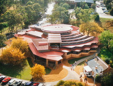
Photo album, Aerial view showing the new Eltham Library, 1994, 1994
Library Development The library building has been designed to reflect its parkland setting. External features include: the roof which includes interesting aspects when viewed from Main Road; verandahs which provide ramp access and give a sheltered entrance to the building; walls which feature locally-made mudbricks, conventional bricks and copper panels; and space for an outdoor courtyard/reading area which will be developed later. Internally there are a number of features. The building includes a foyer with a fireplace suitable for displays including artwork; a community multi-purpose room suitable for meetings or functions and an outdoor cafeteria. The ceilings are lined with Victorian Ash. The shapes for the ceiling give a free flowing form to the building. Brush Box has been used for the circulation and information desks. The tree trunk columns are Grey lronbark from New South Wales. Arches and and various-shaped windows add interest to the internal structure. The carpet design reflects the Eltham environment and compliments the natural colours and timbers used in the building. Tiles by artist Felix Bosari feature in the building and additional art by local artists will be added externally and internally to the building. The library floor area is approximately 1200 sq metres and houses a collection of 50,000 items. The community multi-purpose room, foyer and community display area totals approximately 300 sq metres. These areas will be available to the community for such events a~ meetings, displays, classes, functions and art exhibitions. The Toy Library and Adult Literacy Group will also be based in the new complex. The value of works/services and fittings/ furniture is $3,040,000 Project Team Project Director: John Stamp, Director - Major Projects Project Manager: Noel Mcinnes, Noel Mcinnes Project Management Pty Ltd Architects: Gregory Burgess and Peter Ryan, Gregory Burgess Pty Ltd Site Foreman - Building Works: John Mantel Site Foreman - Site Works and Foundations: Steven White, Shire of Eltham Surveyor: Gregory Slater, Shire of Eltham Builder: Shire of ElthamPhoto album of the new Eltham Library presented to the Society by Cr R.J. Manuell, Chairperson Eltham Library Redevelopment Special Committee, 28 Nov 1994 in recognition of the efforts and contribution made by the Shire of Eltham Historical Society to the construction of the Eltham Library complex.Black faux leather album cover, black pages, brass corners and screws, 10 page inserts separated by tissue, 12 photos and information sheets stuck to pages.eltham, eltham library, panther place, shire of eltham, yarra plenty regional library -
 Federation University Historical Collection
Photograph - Photorgraphs - Black and White, Aerial Photographs around the Ballarat School of Mines, Pre 1967
Ballarat School of Mines is in Lydiard Street South, in close proximity to White Flat oval. 3821.1 & .2 - Black and white photograph taken from an aeroplane over Ballarat. Shows Ballarat School of Mines, Ballarat Gaol, Ballarat Girls' Technical School, gasometers, White Flat, Yarrowee Channel. 8251.3 & .4 & .5 - Black and white photograph taken from an aeroplane over Ballarat. Shows Ballarat School of Mines, Ballarat Gaol, Ballarat Junior Technical School, Albert Street, Gaol garden, Manchester Unity Hall ballarat school of mines, aerial photograph, hickman street, white flat oval, former ballarat gaol, ballarat girls' technical school, gasometer, aeroplane, white flat, armstrong street south, ballarat gaol, manchester university hall -
 Federation University Historical Collection
Photograph - Colour, Aerial Photographs of the Federation University Mt Helen Campus
Seven colour photographs and a number of negative strips of the Mt Helen Campus, including student residences.mount helen, mount helen campus, federation university, student residences -
 Federation University Historical Collection
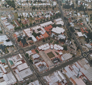
Photograph, Aerial view of the Ballarat School of Mines Lydiard Street Campus
Large format colour photograph of the Ballarat School of Mines Campus.smb campus, aerial photograph, aerial photograph smb, ballarat school of mines, ballarat school of mines, lydiard street south, ballarat -
 Federation University Historical Collection
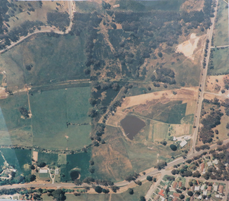
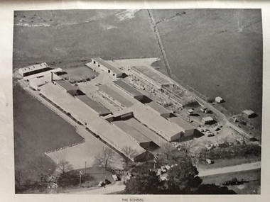
Photograph, Aerial photograph of Mount Helen Campus prior to construction, c1967, c1967
Laminated large format coloured photographic print of the farmland at Mount Helen that bacame the Mount Helen Campus. mount helen campus aerial, colour photograph, aerial photograph -
 Federation University Historical Collection
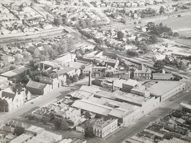
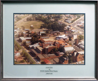
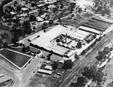
Photograph - coloured, Aerial view of SMB Lydiard Street Campus, March 1982, March 1982
SMB was established on the area on the area of the Ballarat Gaol. The Gaol has been demolished but the Brewery still stands. Hillman Recreation Centre is under construction. The tennis courts are still evident, now the site of the M B John Building.Timber frame with silver/red paint, pale blue and dark blue mount board with glass.ballarat school of mines, ballarat gaol, hillman recreation building, tennis courts, m b john, brewery -
 Victorian Interpretive Projects Inc.
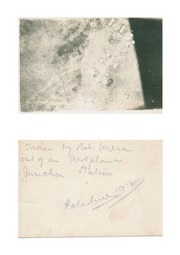
Photograph - digital, Bah Wilson, Aerial photograph of Palestine taken during World War One, 1918, 1918
verso: Taken by Bah Wilson out of an aeroplane. Junction Station. Palestine 1918palestine, aerial photograph, aeroplane, world war, world war one, junction station, mmm -
 Moorabbin Air Museum
Work on paper (item) - The Development of Aerial Transport in Australia
-
 National Vietnam Veterans Museum (NVVM)
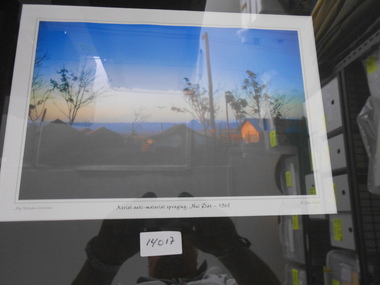
Photograph, Aerial Anti-Malarial spraying Nui-Dat 1968, 1968
Coloured Photograph of an Aircraft spraying Anti-Malarial chemicals over camp at Nui Dat at dusk.My Vietnam Collection- John Siladiphotograph, chemical warfare, nui dat -
Moorabbin Air Museum
Document (item) - GAF - Notes On Proposal To Convert Canberra Aircraft To Aerial Tanker Role
-
 National Vietnam Veterans Museum (NVVM)
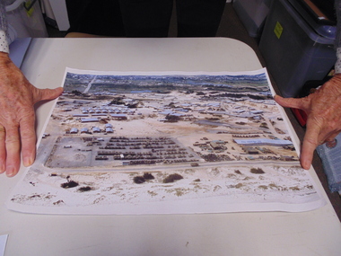
Photograph, Aerial Photograph
A coloured photograph taken from the aire of Vung Tau Army BasePhotograph,Vung Tau Army Base -
 St Kilda Historical Society
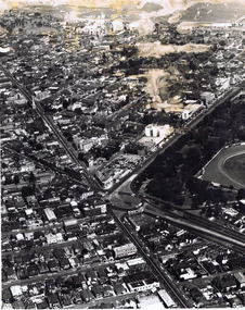
Photograph, Aerial view of St Kilda Junction, c. 1970?
black and white photograph poor condition unmountedCopyright. This photograph may not be reproduced without permission in writing from the Editor of "The Age". 250 Spencer Street, Melbourne and 39/41 York st, Sydney. -
 St Kilda Historical Society
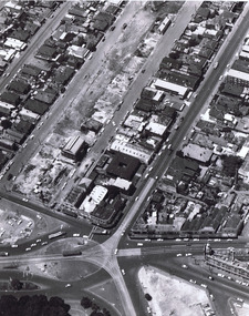
Photograph, Aerial view of St Kilda Junction, c. 1967(?)
thought to be 24 April 19672 black and white photographs: one matt, one glossy unmountedCopyright. This photograph may not be reproduced without permission in writing from the Editor of "The Age". 250 Spencer Street, Melbourne and 39/41 York st, Sydney. A4582 24.4.1967 -
Tatura Irrigation & Wartime Camps Museum
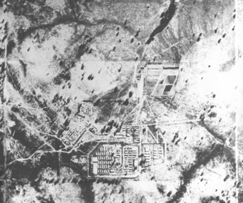
Photograph, Aerial camp 13, 1946
Aeriel photo of Camp 13Black and white photograph. Aeriel view of Camp 13.camp 13, murchison camp, internment camp 13 -
 Lake Bolac & District Historical Society
Black and white photograph, Aerial view of Lake Bolac township, circa 1970
Lake Bolac township, 1970. This picture shows the 2nd football oval, tennis courts, golf course and racecourse (front-right) above the salt lake and the Lake Bolac Common (front-left). The Primary School is still on its original site between the oval and the Ararat road. The High School is beside the fresh-water lake (centre back) and to its left are the early caravan park and bowling club. The Aquatic Club shed can just be seen behind the lake bank. Photograph taken by Lewis Wills.lake bolac, football oval, tennis courts, race track, golf course, bowling club, caravan park, aquatic club shed, primary school, high school -
 Tatura Irrigation & Wartime Camps Museum
Photograph, camp 1 aerial photo 1946
camp 1 aerial photo 1946, photograph -
 Inverloch Historical Society
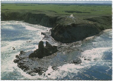
004349 Postcard Photograph - Aerial View of Eagles Nest, Inverloch - from Nina Banks - Digital Copy only
-
 Inverloch Historical Society
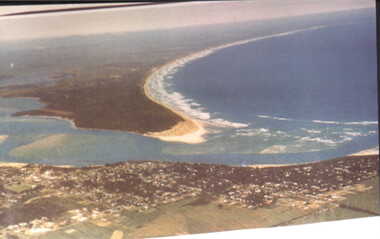
000083 - Photograph - Aerial view from Pt (Point) Smythe - Inverloch - R Young
-
 Inverloch Historical Society
000146 - Photograph - Aerial Photograph - R Young
-
 Stawell Historical Society Inc
Photograph, North Western Woollen Mills -- Aerial Photo
North Western Woollen Mills Pty. Ltd.stawell -
Stawell Historical Society Inc
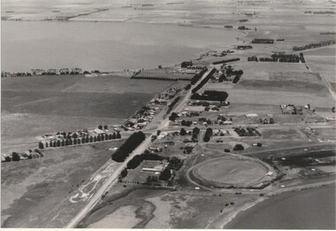
Photograph - Large Print, Aerial View of Pleasant Creek Training Centre and North Western Woolen Mills, c1975
Taken when buildings were at their peak. Referred to as Pleasant Creek Training Centre or Pleasant Creek Special SchoolMainly yellow coloured with Pleasant Creek Training Centre in middle and with Stawell North Western Woolen Mills at top right.VIC 25996 A1x10.3 QASCO VIC IMAGE 03 9682 3330education, manufacturing -
Stawell Historical Society Inc
Map, Western Mining Corp / Stawell Joint Venture, Aerial Photo of Wonga Open Cut and Tailings Dam No 2 proposed extension, January 1991
Shows proposed extension No2 Tailings Dam off Lavett Road and proposed Revegetation Corridors Western Mining Corporation Limited Stawell Joint Venturemining, gold, map -
Whitehorse Historical Society Inc.
Map, Aerial photographs Nunawading, 1972
Department of Crown Lands and Survey, Melbourne, 1972.Department of Crown Lands and Survey, Melbourne, 1972. Project runs 34 - 39 - City of Nunawading. frames numbered from South to North boundaries, each strip numbered from West to east. The series extends further West to Box Hill and East to Ringwood than the 1970 project. No index map. Sheets 39/2 and 34/28 missing.non-fictionDepartment of Crown Lands and Survey, Melbourne, 1972.victoria. department of crown lands and survey, aerial photographs, nunawading, mitcham, blackburn, blackburn north, blackburn south, forest hill, vermont, burwood east, box hill, ringwood, vermont south -
Whitehorse Historical Society Inc.
Map, Aerial photographs Nunawading, 1976
Department of Crown Lands and Survey, Melbourne, 1976 Project.Department of Crown Lands and Survey, Melbourne, 1976 Project. Runs 29 - 33 City of Nunawading. Frames numbered from South to North boundaries, each strip numbered from West to East. No index map. Sheets 30/8 and 30/9 missing.non-fictionDepartment of Crown Lands and Survey, Melbourne, 1976 Project. victoria. department of crown lands and survey, aerial photographs, nunawading, mitcham, blackburn, blackburn north, blackburn south, forest hill, vermont, vermont south, burwood east, box hill, ringwood -
Whitehorse Historical Society Inc.
Map, Aerial maps, 2/04/1966 12:00:00 AM
Melbourne 1966 project, runs 10A and 11A, lens 122 151.75 mm 9,800. Photo nos 77, 107, 109, 161, 163, 165.Melbourne 1966 project, runs 10A and 11A, lens 122 151.75 mm 9,800. Photo nos 77, 107, 109, 161, 163, 165. Areas and boundaries: Map no 77 W. Park and Cook Roads; E. Dubon Rd; N Oban Rd; S Reilly St. Map No 107. W. Indra Rd and Pakenham St; E. Rooks Rd & McLares Rd; N. Maroondah Hwy; S. Hawthorn Rd & Eley Rd. Map No 109 W. Elgar Rd. E. Blackburn Rd & McKean St; S. Eley Rd & Burwood Hwy. Map No 161. W. Elgar Rd & Huntingdale Rd; E. Blackburn Rd; N. Burwood Hwy; S. Waverley Rd. Map No 163. W. Blackburn Rd; S. Springvale Rd; N. Eley Rd & Hawthorn Rd; S. Glen Waverley Railway Line. Map No 165. W. Stanley Rd, Vermont South; E. Cathies Lane, Wantirna South; N. North of Burwood Hwy; S. High Street. Melbourne 1966 project, runs 10A and 11A, lens 122 151.75 mm 9,800. Photo nos 77, 107, 109, 161, 163, 165. aerial photographs, blackburn, blackburn south, forest hill, nunawading, box hill, burwood, burwood east, donvale, mount waverley, glen waverley, wantirna, vermont south, mitcham, ringwood north, ringwood -
 Ballarat Heritage Services
Photograph - Black and White, Ballarat East High School, aerial photographs
Three black and white photographs of the Ballarat East High School. ballarat east high school, education -
 Ballarat Heritage Services
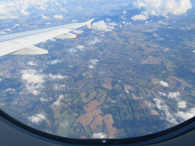
Photograph - Colour, London Aerial Photograph, 2016
Photograph of London from the air.aerial photograph, london -
 Dandenong/Cranbourne RSL Sub Branch
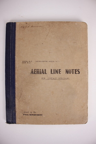
Book, Aerial Line Notes, Circa. 1944
Carried by Sig. Robinson on operations. P rinted in Melbourne. By Postmaster.s General Department. Brown cardboard cover. White paper pagesSig.J.S.Robinson. -
 City of Ballarat Libraries
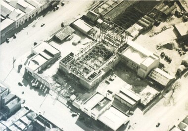
Photograph - Card Box Photographs, Aerial view of the Civic Hall under construction, Ballarat circa 1951
This photo shows the buildings still standing around the Civic Hall as it was being constructed.civic hall, ballarat, mair street, aerial view, armstrong street north, building, construction, public building