Showing 8373 items matching " bridge"
-
 Kew Historical Society Inc
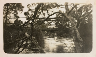
Photograph - Bridge, c.1927
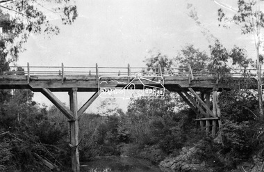
Henry Beater Christian (1886-1962) , was a descendant of one of the earliest settler families in Kew. Employed at the Kew Asylum as a 'public servant', he was a skilled amateur photographer, photographing numerous scenes in Kew and on his travels around Victoria. The majority of his photographs date from 1916 to 1929. His finest photographs are housed in two photograph albums. Digital copy of a photograph from page 26 of the 47-page photograph album containing 261 gelatinous silver images, loaned by Diane Washfold with permission given to digitise and hold a copy in our collection. John Chapman has written in 'Bushwalking Clubs - A Brief History', about the establishment in Victoria of the first bushwalking club in 1888, and the popularisation of bushwalking during the interwar period. Henry Christian's 'walks' appear to have been undertaken solely or with a companion/s. Here the photographer takes a wooden bridge across a river.Inscription on page illegiblehenry beater christian (1886-1962), landscape photography, christian-washfold collection, photograph albums, bushwalking -
 Kew Historical Society Inc
Work on paper, John Shirlow, View Across Princes Bridge, 1931
Original and framed etching of Princess Bridge Melbourne, created by John Shirlow in 1931.Framed black and white etching by John Shirlow of the view across Princes Bridge [Melbourne] looking north. The work is signed in pencil below the signed and dated etching.Artist's signature lower rightaustralian art, etchings, john shirlow, princes bridge - melbourne (vic) -
 Eltham District Historical Society Inc
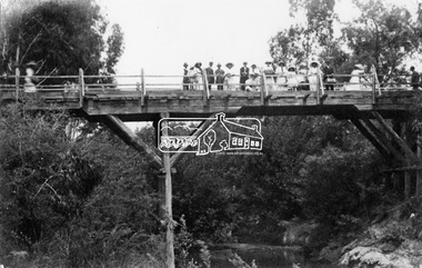
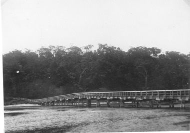
Negative - Photograph, Hurst's Bridge, c.1912
The area of Hurstbridge was originally known as Hurst’s-bridge after the timber bridge built over the Diamond Creek near Hurst’s station in late 1881/early 1882. A large group of people can be seen strolling across the timber bridge over the Diamond Creek on Hurstbridge-Arthurs Creek Road, Hurstbridge. It was built by John McDonald, of Arthur's Creek and was demolished and replaced in 1917 by a reinforced concrete arch bridge designed by John Monash.This photo forms part of a collection of photographs gathered by the Shire of Eltham for their centenary project book, "Pioneers and Painters: 100 years of the Shire of Eltham" by Alan Marshall (1971). The collection of over 500 images is held in partnership between Eltham District Historical Society and Yarra Plenty Regional Library (Eltham Library) and is now formally known as 'The Shire of Eltham Pioneers Photograph Collection.' It is significant in being the first community sourced collection representing the places and people of the Shire's first one hundred years.Digital image 4 x 5 inch B&W Negshire of eltham pioneers photograph collection, 1912, bridge, diamond creek (creek), hurstbridge, hurst's bridge -
 Marysville & District Historical Society
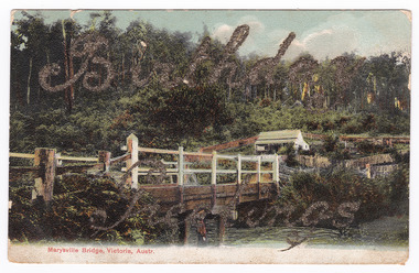
Postcard (item) - Colour tinted postcard, Nicholas John Caire, Marysville Bridge, Victoria, Austr, 1878-1904
One of a series of postcards of photographs taken by socialite photographer Nicholas John Caire.One of a series of postcards of photographs taken by socialite photographer Nicholas John Caire. N.J. Caire had a great love for the area in and surrounding Marysville and in the late 1800's took many photographs of Marysville and its surrounds. N.J. Caire was born in 1837 in Guernsey. He arrived in Adelaide about 1860 along with his parents who encouraged his early interest in photography. He opened a studio in Adelaide in 1867 after traveling extensively throughout the Gippsland taking photographs. After marrying in 1870 he moved to Talbot in Victoria until 1876 when he opened a studio in the Royal Arcade in Melbourne. After 1885 N.J. Caire gave up his city work and made his home in South Yarra and devoted the rest of his life to outdoor photography, specializing in the bush, the gullies and the mountains of south-eastern Victoria.Birthday/ Greetings POST CARD This Space may be Used/ for Correspondence The Address Only to be/ Written Here. 88421 Dear Ivy/ Wishing you/ many happy/ returns of/ the day/ from Reggie Miss Ivy Bastian/ Helston/ Fenwick Street/ Nth Carlton c1918 2nd Bridge The postage stamp has been removed. Helen Boach?marysville, victoria, nicholas john caire, bridge scene, 88421, postcard, souvenir -
 Greensborough Historical Society
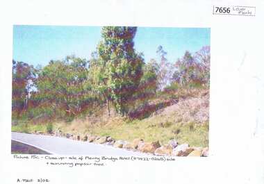
Photograph - Photograph (Copy), Anne Paul, Plenty Bridge Hotel site, 2003_03
21st century photograph of heritage site: former Plenty bridge Hotel and Tollhouse, situated on the eastern side of Old Lower Plenty Road, near the Old Lower Plenty Road Bridge on the east bank of the Plenty River. Although the Hotel burnt down, poplar trees still exist on the site.3 pages, 1 x colour photograph printed on paper, 1 x Heritage Inventory (text) and 1 historic black and white photo.On colour photograph: Close-up site of Plenty Bridge Hotel (H7922-0265) and surviving poplar tree. A. Paul 3/03plenty bridge hotel, lower plenty, plenty river -
 Eltham District Historical Society Inc
Photograph, Old Bridge, Kaylock's Crossing, Brougham Street, Eltham, c.1895
Brougham Street was created in Josiah Holloway's 1851 subdivision of Little Eltham. It was one of several east-west streets shown on the subdivision plan as crossing the Diamond Creek. The western part was named Wellington Street on the subdivision plan but was later changed to conform with the name of the eastern part as acknowledgement of the continuity of the street. It is not known when the first bridge was constructed in Brougham Street however it was certainly mentioned at Council’s meeting of 2 June 1884 as being in a dangerous state of repair. This photo (c.1895) of an old bridge shows a very low-level simple log girder bridge crossing the creek at a right angle and so the approaches involved bends in the road alignment. This bridge was generally known as Kaylocks Bridge or Kaylock’s Crossing after the owner of the adjoining land. It was most likely built from around the mid-1850s, or a crossing of some fashion established as Richard George Kaylock, butcher of Little Eltham and his wife Emily Ann settled there in 1854. His property was in Wellington Street (now Brougham Street) and apparently extended across the Diamond Creek. The land on the western side of the creek was farmed, the house being on the eastern side. Kaylock's Bridge formed part of the original coach road to Eltham and in 1922 was described as an "old rustic bridge". Its low level and insubstantial construction made it susceptible to flood damage, necessitating frequent closures until repairs could be carried out. In September 1922, Council called for tenders for a new timber bridge to be constructed at Kaylock’s crossing. An engineering assessment carried out for the Council by Macleod Consulting at the time of the replacement suggested that the construction details indicate that it was in the 1900s, however this dating could possibly have been the result of numerous repairs undertaken over the years to flood damage. The tender was awarded to Mr Weller of Kangaroo Ground who commenced work in February 1923 on a higher-level timber trestle bridge. Work was slowed due to illness of the contractor and the accidental death of a man in March 1923 following the collapse of the bank after he had jumped into a hole that had just been blasted. The bridge was completed around July 1923 at which point the old structure was pulled up, marking what was described in the ‘Advertiser’ newspaper as the passing of an old and well-loved landmark in the district. In April 1924 the approach to Kaylocks bridge was washed away during the heavy flooding that destroyed the Main Road bridge. The western side was repaired, and an extra span was added to the eastern side using timber from the destroyed Main Road bridge. The bridge was again severely damaged four months later in August 1924 When a lack of finances delayed repairs to the Bridge Street bridge in 1931 (also referred to as Obelisk Bridge at the time), traffic had to detour via Brougham Street for some time. Local residents feared that the Bridge Street bridge might never reopen. Kaylocks Bridge was constantly subject to damage by floods. In the 1934 flood it was submerged by two feet of water. In more recent times the bridge was again severely damaged by flooding and repairs made. A new bridge and adjoining footbridge were constructed in 2009. Part of a slide show presentation "Bridges & Waterways of the Shire" by Russell Yeoman to the 13 September 1989 Society meeting. The presentation included slides of historic photos from the Shire of Eltham Pioneers collections as well as several recent views.Photo of earliest known crossing of the Diamond Creek at brougham StreetPostcard photo printbrougham street, eltham, wellington street, kaylocks bridge, bridge, diamond creek (creek) -
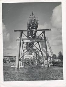 Phillip Island and District Historical Society Inc.
Photographs, Country Roads Board, Phillip Island 2nd Bridge Construction, 1966 - 1969
5 of a collection of 70 photographs taken during the construction and opening of the Phillip Island second bridge - by Country Roads Board and Shire of Bass. Contractor was John Holland & Co Pty Ltd.Five Black & White photographs taken in 1966-1969 of the construction of the Phillip Island second bridge between San Remo and Newhaven. 351-65, 351-66 & 351-69 show the bridge construction. 351-67 & 351-68 show the cutting of the ribbon at the opening and the crowd of people at the opening.351-65: CRG NEG No. 67-3821.phillip island 2nd bridge construction, phillip island bridge opening 1969, country roads board, john holland & co pty ltd, shire of bass, sasha stark -
 Ballarat Heritage Services
Photograph - Photograph - Colour, The Edna Walling Bridge at Locarno Spring in the Hepburn Springs Reserve, 2020, 12/12/2020
The Hepburn Springs Progress Association invited Edna Walling the the Hepburn Springs Reserve, and sandstone paths and bridges resulted. In 1934 there was a proposal to spend 2,000 to 3,000 poinds at the Hepburn Springs Reserve, with a govenrment loan suggested. Colour photograph of the stone bridge at Locarno Spring in the Hepburn Springs Reserve, with the new 'placed' rocks in the surrounds c2000hepburn springs, locarno, mineral water, hepburn springs reserve, locarno spring, edna walling -
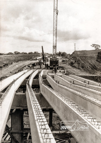
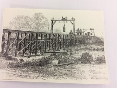 Port of Echuca
Photograph - Black and white photograph of a drawing, A black and white photograph of a drawing of the construction of the bridge crossing the Murray River at Echuca in 1887, 1981
The drawing shows all the activity and building roles involved in building a bridge in 1877. The crossing of the Murray River was very important to citizens living in both Echua, but especially those living in Moama and in further NSW regions as it provided them with access to Victorian market regions. The bridge was built privately for Deniliquin farmers, but eventually opened up to the general public.This is significant because it represents the roles of different tradesmen in the construction industry in the late 19th Century. It also shows construction stages . Bridge pylons are being inserted into the fiver banks. It is also a very well produced drawing, the artist is anonymous, but very skilled.A photograph of a drawing of the construction of the bridge crossing the Murray River in 1877. The picture shows surveyors, construction workers, crane operators, hoists and a crane and much activity.Written on the back in pen are the numbers 6530. In pencil are the numbers 61/8"? and 10"?. Stamped on the back is a small rectangle with the words 'COPYRIGHT. This photograph may not be reproduced without permission in writing from the Editot of "The Age" 250 Spencer Street Melbourne, and 39/41 York St., Sydney.' written inside it.bridge works, murray river crossing, moama, echuca, orm cook collection, 'the age' newspaper., deniliquin farmers, engineering, bridge building, pylons, 1877 -
 Eltham District Historical Society Inc
Negative - Photograph, New bridge at Hurstbridge, 1917
The newly constructed re-inforced concrete arched bridge across the Diamond Creek at Hurstbridge designed by John Monash. Eltham Shire shared the cost of the construction of the bridge with Heidelberg and Whittlesea Shires. The bridge was officially opened on 3rd November 1917. Part of a slide show presentation "Bridges & Waterways of the Shire" by Russell Yeoman to the 13 September 1989 Society meeting. The presentation included slides of historic photos from the Shire of Eltham Pioneers collections as well as several recent views.This photo forms part of a collection of photographs gathered by the Shire of Eltham for their centenary project book, "Pioneers and Painters: 100 years of the Shire of Eltham" by Alan Marshall (1971). The collection of over 500 images is held in partnership between Eltham District Historical Society and Yarra Plenty Regional Library (Eltham Library) and is now formally known as 'The Shire of Eltham Pioneers Photograph Collection.' It is significant in being the first community sourced collection representing the places and people of the Shire's first one hundred years.Digital image 4 x 5 inch B&W Negshire of eltham pioneers photograph collection, hurstbridge, bridge, 1917, diamond creek (creek), monash bridge -
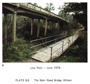 Eltham District Historical Society Inc
Work on paper (Sub-Item) - Photograph, Main Road Bridge, Eltham low flow of Diamond Creek, June 1979
Colour photograph.Main Road Bridge, Eltham low flow of Diamond Creek with wooden pedestrain bridge constructed over the creek as a continuation of the walking and biking trail, June 1979diamond creek, eltham, bridge, main road, pedestrain bridge, trail -
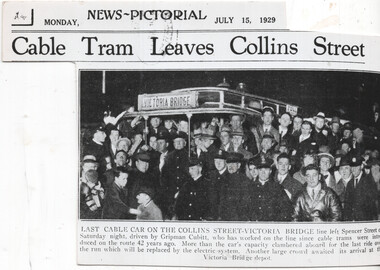 Melbourne Tram Museum
Newspaper, The Sun, The Herald, "Last cable car on the Collins Street - Victoria Bridge", 15/7/1929
Newspaper clipping from the Melbourne The Sun News Pictorial, 15/7/1929 about the closure of the Victoria Bridge line in Victoria St from Brunswick St. Has a photo of the event at the Collins St, Driven by Gripman Cubitt. Second copy is photo printed on heavy paperYields information about the last Victoria St cable tram.Newspaper Clipping - on newsprint or heavy paper. The timeline gives the date of closure of the Brunswick St to Victoria Bridge line as Saturday 13 July 1929. Titled "Last cable car on the Collins Street - Victoria Bridge" Checked for The Argus in Trove - not shown on line.trams, tramways, conversion, victoria bridge, closure, collins st, cable trams, victoria st -
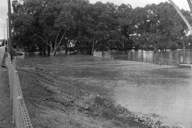 Charlton Golden Grains Museum Inc
Photograph, Cameron, Ian, 1973 flooded Avoca River, Feb 19873
1973 flooded Avoca River. Viewed from west side of Paterson Bridge behind the shire office.B/W photograph of 1973 flooded Avoca River. View West side of Paterson Bridge behind Shire Officeflood, avoca river, charlton -
 Eltham District Historical Society Inc
Photograph, Russell Yeoman, Yarra Glen Road Bridge over Watsons Creek, Kangaroo Ground, c.1970, 1970c
Concrete bridge built in the 1920s.Roll of 35mm black and white negative film, 4 of 7 stripsIlford HP4bridge, bridges, watsons creek, eltham-yarra glen road, yarra glen road, kangaroo ground -
 Eltham District Historical Society Inc
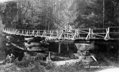
Negative - Photograph, Log bridge over Pheasant Creek, Kinglake, c.1920
Postcard view of pedestrian log bridge in Kinglake National Park. The log bridge over Johnston's Creek is said to have been built to allow the timber tramline to cross the creek. The bridge was destroyed in the 1926 bushfires. Other sources describe this bridge being located at Pheasant Creek (between Kinglake West and Kinglake Central) and that it was built by Mr Munro, the owner of the sawmill.This photo forms part of a collection of photographs gathered by the Shire of Eltham for their centenary project book,"Pioneers and Painters: 100 years of the Shire of Eltham" by Alan Marshall (1971). The collection of over 500 images is held in partnership between Eltham District Historical Society and Yarra Plenty Regional Library (Eltham Library) and is now formally known as 'The Shire of Eltham Pioneers Photograph Collection.' It is significant in being the first community sourced collection representing the places and people of the Shire's first one hundred years.Digital image 4 x 5 inch B&W Neg 1 printshire of eltham pioneers photograph collection, kinglake, log bridge, bridge, mr. munro, timber tramway, pheasant creek -
 Eltham District Historical Society Inc
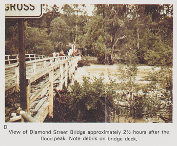
Work on paper (Sub-Item) - Photograph, Flooding, View of Diamond Street Bridge, Eltham 8 April 1977
Colour photograph. Flooding of Diamond Creek at Diamond Street Eltham bridge approximately 2 1/2 hours after the flood peak. Note debris on the bridge deck. 8 April 1977. flood, diamond creek, flooding, eltham, diamond street, bridge -
 Ringwood and District Historical Society
Letter, Personal correspondence - 1985 - including reference to purchase of Burnt Bridge Store by parents of Clarice de Pelsenaire in 1923 and brief history and death of Ringwood East resident, Arthur Meyland (1911-1985)
Incomplete letter from Clarice dePelsenaide, whose parents purchased the Burnt Bridge Store from Mr Williams. Her husband Arthur was the first pupil enrolled at the Ringwood East Primary School.2 pages hand written letter about early East Ringwood and Burnt Bridge Store. +Additional Keywords: dePelsenaide, Clarice -
 Emerald Museum & Nobelius Heritage Park
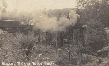
Photograph, Postcard, Belgrave Train on Trestle Bridge, 13/01/1914
Early postcard of Puffing Billy on trestle bridge Faded sepia photograph/postcard depicting Puffing Billy on Trestle BridgeFront: text, Belgrave Train on 'Tressel' Bridge Back: Handwritten text: 13/01/1914? Emerald - Dear Mother we are at Emerald, on our way to L. Pa? Everything is going well. Crarj/ys? are going Dande (Dandenong?) Father slept all night. Will write in a couple of days. Jesse's in good form stocking up provisions. No need to worry, Loving son Blair ?puffing billy, belgrave, whiteside -
 Eltham District Historical Society Inc
Photograph, Russell Yeoman, Fitzsimons Lane Bridge, c.1970, 1970c
New Fitzsimons Lane Bridge prior to duplicationDigital file only; created from original colour positive slide transparencystreets, eltham, bridge, fitzsimons lane bridge, fitzsimons lane, russell yeoman collection -
 Eltham District Historical Society Inc
Photograph, Hurst's Bridge, c.1912
The area of Hurstbridge was originally known as Hurst’s-bridge after the timber bridge built over the Diamond Creek near Hurst’s station in late 1881/early 1882 on Hurstbridge-Arthurs Creek Road, Hurstbridge. It was built by John McDonald, of Arthur's Creek and was demolished and replaced in 1917 by a reinforced concrete arch bridge designed by John Monash. Part of a slide show presentation "Bridges & Waterways of the Shire" by Russell Yeoman to the 13 September 1989 Society meeting. The presentation included slides of historic photos from the Shire of Eltham Pioneers collections as well as several recent views. This photo forms part of a collection of photographs gathered by the Shire of Eltham for their centenary project book, Pioneers and Painters: 100 years of the Shire of Eltham" by Alan Marshall (1971). The collection of over 500 images is held in partnership between Eltham District Historical Society and Yarra Plenty Regional Library (Eltham Library) and is now formally known as 'The Shire of Eltham Pioneers Photograph Collection.' It is significant in being the first community sourced collection representing the places and people of the Shire's first one hundred years.Digital imageshire of eltham pioneers photograph collection, 1912, bridge, diamond creek (creek), hurstbridge, hurst's bridge -
 Lakes Entrance Historical Society
Photograph, North Arm bridge Lakes Entrance Victoria c1900, 1900c
Jemmies Point BridgeBlack and white photograph of the wooden bridge across the North Arm, showing the original width of the North Arm, the start of the road up to Kalimna bordered by a post and rail fence, the heights of Kalimna concealed by dense vegetation. Lakes Entrance Victoriabridges, vegetation, fences -
 Sunbury Family History and Heritage Society Inc.
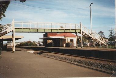
Photograph, Elwyn Davis, Pedestrian Bridge, C1990s
The wooden pedestrian bridge spanned the rail tracks at Sunbury Railway Station and were replaced with a more modern bridge and ramp when upgrades were done at the station and along the Bendigo line in the late 1990s and early 2000s. The water tank beyond the station building was used to refill the engines with water when steam engines were used. Diesel driven V Line trains now convey commuters from the regional towns along the Bendigo region to Melbourne.The Bendigo Line was the first government rail line to open and it reached Sunbury in 1859. It was extended to Bendigo and opened in 1861.A non-digital coloured photograph of a wooden pedestrian bridge spanning rail tracks with a wooden station building and former water tower on the station platform. rail bridges, bendigo rail line, sunbury station, water towers, railways -
 Bendigo Art Gallery
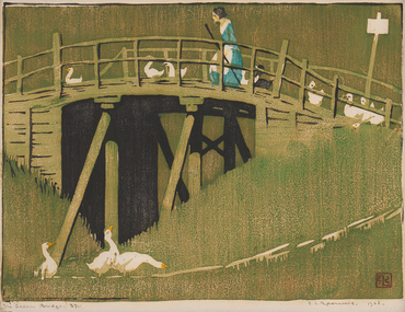
Print - Work on paper, Ethel SPOWERS, The Green Bridge, 1926-1927
l.r; ELS seal, l.r; The Green Bridge 27, l.r; E.L Spowers 1926print, printmaker, printmaking, woodblock, female artist, linocut, bridge, ducks, farming, farm, countryside -
 Eltham District Historical Society Inc
Photograph, Old Lower Plenty Bridge, c.1970
Old bridge across the Plenty River at Lower Plenty now part of the Plenty River Trail. Part of a slide show presentation "Bridges & Waterways of the Shire" by Russell Yeoman to the 13 September 1989 Society meeting. The presentation included slides of historic photos from the Shire of Eltham Pioneers collections as well as several recent views.Black and white photographmain road, plenty river, bridge, lower plenty, plenty river trail -
 Eltham District Historical Society Inc
Negative - Photograph, Russell Yeoman, Old Lower Plenty Bridge, c.1970
Old bridge across the Plenty River at Lower Plenty now part of the Plenty River Trail. Part of a slide show presentation "Bridges & Waterways of the Shire" by Russell Yeoman to the 13 September 1989 Society meeting. The presentation included slides of historic photos from the Shire of Eltham Pioneers collections as well as several recent views.Roll of 35mm black and white negative film, 4 of 7 stripsIlford HP4bridge, lower plenty, main road, plenty river, plenty river trail -
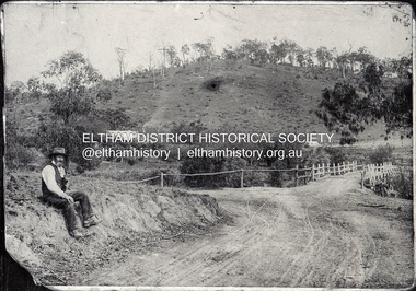
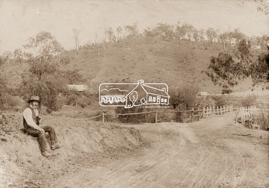 Eltham District Historical Society Inc
Photograph, Mr Belot smokes his pipe whilst resting at Cottle's Bridge, c.1890
The area, previously known as Back Creek, was named after Thomas Cottle, who settled in the district in the 1870s, and the original bridge over the Diamond Creek on the road to Strathewen. The original bridge (seen in the photo) was replaced with a new timber bridge at a cost of £1,500, the tender being awarded to a contractor named Birch who commenced work in June 1927. The gentleman in the photo who is resting whilst having a smoke of his pipe is a member of the Belot family.Original sepia photograph mounted on card broken lower left corner and cracked upper rightbelot, bridge, cottles bridge, cottles bridge-strathewan road, diamond creek (creek), heidelberg-kinglake road -
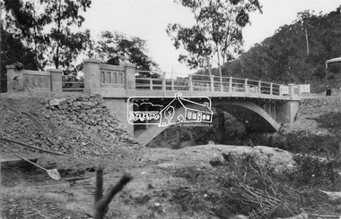
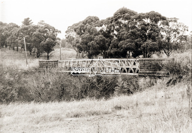
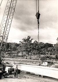
 Eltham District Historical Society Inc
Photograph, Construction of Lower Plenty Bridge, Main Road, c.August 1966, 1966
This black and white photograph records construction activity of the then new Main Road bridge over the Plenty River at Lower Plenty in 1969.Local significanceBlack and white photograph taken during construction of the Main Road bridge over the Plenty River. Includes structural members, construction personnel, vehicles and a Clarke mobile crane.mobile cranes, bridge construction, main road, plenty river, lower plenty, bridges -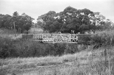
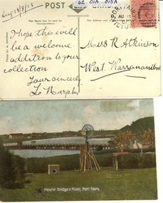 Port Fairy Historical Society Museum and Archives
Postcard - post card, A.C. Aberline, Moyne Bridge & River Port Fairy, c.1900
A card sent to Miss R. Atkinson of West Warrnambool to add to her collection of postcardsHand coloured Photograph of the Moyne river road bridge, a domestic windmill in foreground and in the background large sheds made for use as a postcard with reverse side stamped Front:- Moyne bridge & river, port Fairy. Reverse:- aug.13/8/08- i hope this will be a welcome addition to your collection yours Sincerly, L Murphy - To Miss R Atkinson, West Warrnambool moyne bridge, moyne river, windmill -
 Eltham District Historical Society Inc
Negative - Photograph, Mr Belot smokes his pipe whilst resting at Cottle's Bridge, c.1990 (c.1890)
Copy of original photograph. The area, previously known as Back Creek, was named after Thomas Cottle, who settled in the district in the 1870s, and the original bridge over the Diamond Creek on the road to Strathewen. The original bridge (seen in the photo) was replaced with a new timber bridge at a cost of £1,500, the tender being awarded to a contractor named Birch who commenced work in June 1927. The gentleman in the photo who is resting whilst having a smoke of his pipe is a member of the Belot family.Roll of 35mm Black and White negative film, 3 strips, (1 of 14 frames)Film - Agfa Ortho 25belot, bridge, cottles bridge, cottles bridge-strathewan road, diamond creek (creek), heidelberg-kinglake road