Showing 493 items matching " county of bendigo"
-
 Bendigo Historical Society Inc.
Document - MCCOLL, RANKIN AND STANISTREET COLLECTION: DEBORAH EXTENDED GOLD MINING COMPANY NL, 1968
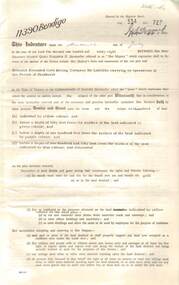
... Street, County of Bendigo, Parish of Sandhurst.... Street, County of Bendigo, Parish of Sandhurst. Document MCCOLL ...Document: McColl, Rankin and Stanistreet - Deborah Extended Gold Mining Company gold mining lease document. No. 11390, Vol. 334, Fol. 727, dated 21 Sept. 1967, - adjoins Fletcher Street, County of Bendigo, Parish of Sandhurst.organization, mining, deborah extended gold mining compan, mccoll, rankin and stanistreet, deborah extended gold mining company, gold mining, lease documents -
 Bendigo Historical Society Inc.
Map - TOWNSHIP OF LOCKINGTON, 21/09/1915
... Map: Township of Lockington, Parish of Bamawm, County...: Township of Lockington, Parish of Bamawm, County of Bendigo. Parish ...Map: Township of Lockington, Parish of Bamawm, County of Bendigo. Parish plan.Has a clipping from 'The Riverine Herald' dated 20/11/1915 on the reverse side re. the sale of blocks in Bamawm Township (number 322 in map cupboard 1)map, bendigo, township, lockington, bamawm, the riverine herald -
 Bendigo Historical Society Inc.
Map - ELMORE, 3/03/1875
... Map: Elmore, County of Bendigo. Parish plan Paper canvas...: Elmore, County of Bendigo. Parish plan Paper canvas backed ...Map: Elmore, County of Bendigo. Parish plan Paper canvas backed. Compiled under the superintendence of Mr. BIERS November 12th W. H. GREGSON DRAUGHTSMAN Compiled from local plans 31.215.216.502.833. Examined by E. D. 27.11.74map, bendigo, parish plan, elmore, w.h. gregson, mr. biers -
 Bendigo Historical Society Inc.
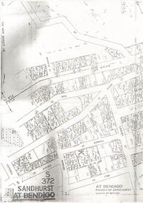
Map - LONG GULLY HISTORY GROUP COLLECTION: SANDHURST AT BENDIGO
... of Sandhurst, County of Bendigo. Some of the street names are: Quick... at Bendigo, Parish of Sandhurst, County of Bendigo. Some ...Copy of a map titled Sandhurst at Bendigo, Parish of Sandhurst, County of Bendigo. Some of the street names are: Quick, Rae, Casley, Bell. Thomas, Victoria, Roeder and Prout Streets. Allotments have the date, size, measurements and names on them. Some are unreadable.bendigo, history, long gully history group, the long gully history group - sandhurst at bendigo -
 Bendigo Historical Society Inc.
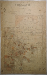
Map - NEILBOROUGH, 6/12/1882
... Map: Parish of Neilborough, County of Bendigo. Parish plan... J V Walshe Map: Parish of Neilborough, County of Bendigo ...Map: Parish of Neilborough, County of Bendigo. Parish plan. J A Morrison Junior June 1877. Examined by ? Harvey 21/8/1877. Additions made by J V Walshe24/10/82. Examined by E D 39/10/82.map, bendigo, parish plan, neilborough, j a morrison jr., harvey, j v walshe -
 Bendigo Historical Society Inc.
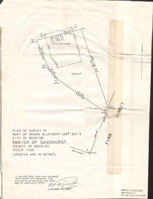
Document - CROWN ALLOTMENT 406A (PLAN) JOSS HOUSE
... of Bendigo. Parish of Sandhurst. County of Bendigo. Scale 1:500.... Parish of Sandhurst. County of Bendigo. Scale 1:500. (Copy ...Plan of Survey of part of Crown Allotment 406A Sec E. City of Bendigo. Parish of Sandhurst. County of Bendigo. Scale 1:500. (Copy of Original). As at 21 February 1979. This survey shows the location of the Joss House and the portion of land where it is located.plan, bendigo, joss house, crown allotment 406a (plan), joss house -
Bendigo Historical Society Inc.
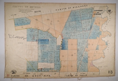
Map - NOLAN, COUNTY OF BENDOGO, 7-5-30
... Map, Nolan, County of Bendigo, Egerton; Elmore; Goornong... Bendigo nolan H.J.Green,Government Printer Map, Nolan, County ...Map, Nolan, County of Bendigo, Egerton; Elmore; Goornong. Campaspe River, Elmore Estate, By Authority: H.J.Green, Government Printer,Melbourne.Price 2/-.Drawn and Reproduced at the Dept. of Lands and Survey,Melbourne,Victoria.7-5-30. (number 1 in map cupboard 1)H.J.Green,Government Printermap, bendigo, nolan -
 Bendigo Historical Society Inc.
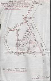
Plan - MCCOLL, RANKIN AND STANISTREET COLLECTION: PLAN OF SURVEY OF DAM SITE, 1941
... of Sandhurst, County of Bendigo. Signed by Garnet G Birch 1 Feb 1941... C, City of Bendigo, Parish of Sandhurst, County of Bendigo ...McColl Rankin & Stanistreet, Plan of Survey of Dam site, Part of Crown Allotment 98 Section C, City of Bendigo, Parish of Sandhurst, County of Bendigo. Signed by Garnet G Birch 1 Feb 1941. 33.5 x 43. Attached is a Copy of Field notes, Dam Site in Crown Allotment 198 Sec. City of Bendigo, Parish of Sandhurst. True Meridian, County of Bendigo, Area 0A 1R 16P. Signed Garnet G Birch, 1/2/1941. Drawn in red and black pen. 20.8 x 33. Both maps are for Deborah Extended Gold Mining Co. No Liabilityorganization, mining, deborah extended gold mining co nl, mccoll rankin & stanistreet, plan of survey of dam site -
Bendigo Historical Society Inc.
Map - RAVENSWOOD, COUNTIES OF BENDIGO & TALBOT, 12-12-22
... Map, Ravenswood, Counties of Bendigo & Talbot, Shelbourne..., Ravenswood, Counties of Bendigo & Talbot, Shelbourne, Walmer ...Map, Ravenswood, Counties of Bendigo & Talbot, Shelbourne, Walmer, Harcourt, Sutton Grange, Mandurang, Lockwood.By Authority A.J.Mullett, Govt. Printer, Melbourne. Photo-Lithographed at the Dept. of Lands and Survey, Melbourne by W.J.Butson 12-12-22, Price1/-. (number 87 in map cupboard 1)A.J.Mullett. Govt. Printer, Melbourne.map, bendigo, ravenswood -
Bendigo Historical Society Inc.
Map - BAGSHOT, COUNTY 0F BENDIGO, 24-5-21
... BAGSHOT, COUNTY 0F BENDIGO....Map, Bagshot, County of Bendigo,Whirrakee, Egerton..., Bagshot, County of Bendigo,Whirrakee, Egerton, Goornong, Ellesmere ...Map, Bagshot, County of Bendigo,Whirrakee, Egerton, Goornong, Ellesmere, Wellsford, Huntly, Reedy Creek, Sandy Creek.Photo-Lithographed at the Dept. of Lands and Survey, Melbourne by W.J.Butson, 24-5-21. Price 1/-.. By authority A.J.Mullett, Govt. Printer,Melbourne. (number 49 in map cupboard 1)A.J.Mullett, Government Printer, Melbourne.map, bendigo, bagshot -
Bendigo Historical Society Inc.
Map - CAMPBELL COLLECTION: BENDIGO AND DISTRICT MAPS, June 1953
... Map. Marong, County of Bendigo, Scale 40 chains to 1 inch.... Marong, County of Bendigo, Scale 40 chains to 1 inch. Woodstock ...Map. Marong, County of Bendigo, Scale 40 chains to 1 inch. Woodstock, Leichardt, Nerring, Sandhurst, Lockwood, Shelbourne. Drawn and reproduced at the Department of Lands and Survey, Melbourne, Victoria. By Authority : W.M. Houston, Government Printer. June 1953. Price 2/-. (number 403 in map cupboard 1)W.M. Houston, Government Printer.map, bendigo, agricultural lands -
Bendigo Historical Society Inc.
Map - AXEDALE, COUNTIES OF BENDIGO & RODNEY, 1961
... Map, Axedale, Counties of Bendigo & Rodney.Axe Creek..., Axedale, Counties of Bendigo & Rodney.Axe Creek, Campaspe River ...Map, Axedale, Counties of Bendigo & Rodney.Axe Creek, Campaspe River, Longlea Railway Station, Axedale Railway Station, Wallan & Bendigo Railway.Township of Axedale. By authority A.C.Brooks, Govt. Printer, Melbourne.Drawn and reproduced at the Dept. of Lands and Survey, Melbournd. Price 1/-. 1961. (number 61 in map cupboard 1)A.C.Brooks, Government Printer, Melbourne.map, bendigo, axedale -
 Bendigo Historical Society Inc.
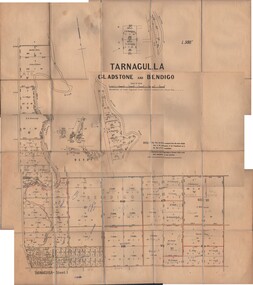
Map - JACK FLYNN COLLECTION: TARNAGULLA SHEET 1, No date visible
... Map: Parish of Tarnagulla Sheet 1, Counties of Gladstone... Sheet 1, Counties of Gladstone and Bendigo. Map JACK FLYNN ...Map: Parish of Tarnagulla Sheet 1, Counties of Gladstone and Bendigo.map, gladstone, parish plan, tarnagulla sheet 1 -
Bendigo Historical Society Inc.
Map - CAMPBELL COLLECTION: BENDIGO AND DISTRICT MAPS, March 1947
... Map. Mandurang, County of Bendigo, Sandhurst.... Mandurang, County of Bendigo, Sandhurst, Strathfieldsaye, Sedgwick ...Map. Mandurang, County of Bendigo, Sandhurst, Strathfieldsaye, Sedgwick, Sutton Grange, Ravenswood, Lockwood. Scale 40 chains to 1 inch. Drawn and reproduced at the Department of Lands and Survey, Melbourne, March 1947, price 2/-. By Authority : J.J. Gourley, Government Printer, Melbourne. (number 402 in map cupboard 1)J.J. Gourley, Government Printer.map, bendigo, allotments -
Bendigo Historical Society Inc.
Map - CAMPBELL COLLECTION: BENDIGO AND DISTRICT MAPS, August 1952
... Map. Nerring, County of Bendigo, Yarraberb, Neilborough..., County of Bendigo, Yarraberb, Neilborough, Leichardt, Marong ...Map. Nerring, County of Bendigo, Yarraberb, Neilborough, Leichardt, Marong, Sandhurst, Huntly. Scale 20 chains to 1 inch. Drawn and reproduced at the Department of Lands and Survey, Melbourne, Victoria, August 1952. Price 2/-. By Authority J.J. Gourley, Government Printer, Melbourne. (number 404 in map cupboard 1)J.J. Gourley, Government Printermap, bendigo, allotments -
Bendigo Historical Society Inc.
Map - CAMPBELL COLLECTION: BENDIGO AND DISTRICT MAPS, 1963
... Map. Sedgwick, County of Bendigo. Scale 20 chains to 1 inch.... Sedgwick, County of Bendigo. Scale 20 chains to 1 inch ...Map. Sedgwick, County of Bendigo. Scale 20 chains to 1 inch. Strathfieldsaye, Eppalock, Lyell, Mandurang, Sutton Grange, County of Talbot. By Authority A.C. Brooks,Government Printer, Melbourne. Drawn and reproduced at the Department of Lands and Survey, Melbourne.1963. Price 2/-. (number 405 in map cupboard 1)A.C. Brooks, Governmenr Printer, Melbourne.map, bendigo, allotments -
 Bendigo Historical Society Inc.
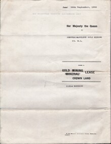
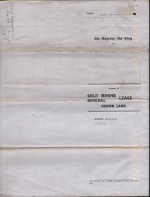
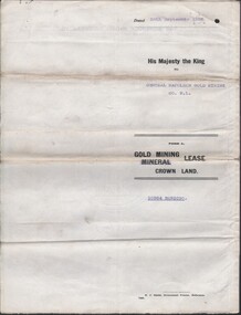
Document - MCCOLL, RANKIN AND STANISTREET COLLECTION: CENTRAL NAPOLEON GOLD MINING CO. N.L, 22nd June 1954
... District of Bendigo County of Bendigo Parish of Sandhurst, During... George VI, Map: Mining District of Bendigo County of Bendigo ...Document :Form A, Gold Mining Lease Crown Land 11314 Bendigo, Entered in the Register Book, Vol. 333 Fol. 138, Embossed seals of Central Napoleon and King George VI, Map: Mining District of Bendigo County of Bendigo Parish of Sandhurst, During the reign of Queen Elizabeth II, 4 pages.organization, business, industry - mining, mccoll rankin & stanistreet, mining, gold mining, central napoleon -
Bendigo Historical Society Inc.
Map - CAMPBELL COLLECTION: BENDIGO AND DISTRICT MAPS, 1962
... Map. Mandurang, County of Bendigo. Scale 40 chains to 1..., County of Bendigo. Scale 40 chains to 1 inch. Sandhurst ...Map. Mandurang, County of Bendigo. Scale 40 chains to 1 inch. Sandhurst, Strathfieldsaye, Sedgwick, Sutton Grange, Ravenswood, Lockwood, Township of Kangaroo Flat, Township of Mandurang. By Authority A.C. Brooks, Government Printer, Melbourne. Drawn and Reproduced at the Department of Lands and Survey, Melbourne,1962, Price 2/-. (number 401 in map cupboard 1)A.C. Brooks, Government Printer.map, bendigo, allotments -
Bendigo Historical Society Inc.
Map - HARCOURT, December 1951
... Harcourt, County of Bendigo, Walmer, Castlemaine, Sutton.... Harcourt, County of Bendigo, Walmer, Castlemaine, Sutton Grange ...Harcourt, County of Bendigo, Walmer, Castlemaine, Sutton Grange. Mt.Alexander Trig. Station, Barkers Creek, Faraday, Calder Highway, Northern Railway. By Authority J.J.Gourley, Government Printer, Melbourne,Drawn and Reproduced at the Dept. of Lands and Survey, Melbourne, Victoria. December 1951. Price 5/-per sheet. (number 35 in map cupboard 1)J.J.Gourley, Government Printer, Melbourne.map, bendigo, harcourt -
 Bendigo Historical Society Inc.
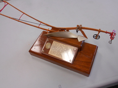
Award - THELMA DRUMMOND COLLECTION: SCALE MODEL ONE FURROW PLOUGH, 1887
... , Victoria. The silver medal is inscribed "County of Bendigo...Bendigo Historical Society Inc. Bendigo Historical Society ...Scale model of one furrow plough as used by early settlers. Made by William Ashman, formerly of Eaglehawk and late of Essendon. Presented by his daughter, Thelma Drummond of Box Hill, Victoria. The silver medal is inscribed "County of Bendigo Agricultural and Horticultural Societry. Awarded to Wm Ashman, Eaglehawk for model plough. Spring Show 1887".agriculture, farm, model plough -
 Bendigo Historical Society Inc.
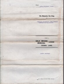
Document - MCCOLL, RANKIN AND STANISTREET COLLECTION: CENTRAL NAPOLEON GOLD MINING CO. N.L, 15th December 1934
... : No 10260, Mining district of Bendigo, Parish of Sandhurst, County... of Bendigo, Parish of Sandhurst, County of Bendigo, During the Reign ...Document: Gold Mining Lease Crown Land, No 10260 Bendigo, Entered in the register book vol. 307 fol. 34041, embossed seals of Central Napoleon Gold Mining Co N.L. & King George V, Map: No 10260, Mining district of Bendigo, Parish of Sandhurst, County of Bendigo, During the Reign of King George V.organization, business, industry - mining, mccoll rankin & stanistreet, mining, gold mining, central napoleon -
 Bendigo Historical Society Inc.
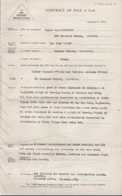
Document - H. A. & S. R. WILKINSON COLLECTION: CONTRACT OF SALE
... section A at Eaglehawk Parish of Nerring County of Bendigo... of Nerring County of Bendigo and being land described in certificate ...Contract of sale of land dated 26 March, 1956 between Mrs. I.M. Arthur (vendor) and Mr. W. R. & Mrs. V. L. O'Toole (purchaser). Property: piece of land part of Crown allotment 53 section A at Eaglehawk Parish of Nerring County of Bendigo and being land described in certificate of title volume 4870 folio 850 and situate 65 Peg Leg Road, Eaglehawk. Also all the land adjoining being part of Crown allotment 41 section A Parish of Nerring County of Bendigo land described in certificate f title volume 3198 folio 573, together with 6 room weatherboard and brick dwelling and all sundry outbuildings. Also all floor coverings, blinds, curtains and electric light fittings and shades. Price: 1,275 pounds.organization, business, h.a. & s.r wilkinson real estate -
 Bendigo Historical Society Inc.
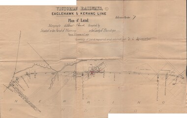
Document - BUSH COLLECTION: PLANS PERTAINING TO LAND OF S. A. BUSH
... Line (Albert Bush land, Parish of Nerring, County of Bendigo...., Parish of Nerring, County of Bendigo. Document BUSH COLLECTION ...A: Plan of subdivision of Allots 6, 7, 8, 15 & 16, Sec. 62C, City of Bendigo (The Property of Albert Bush, Esq.) - Plan is torn in half forming two pieces (see 'Condition'. Pinned note attached to one piece. B: Victoria Railways, Eaglehawk & Kerang Line (Albert Bush land, Parish of Nerring, County of Bendigo.person, individual, bush collection - personal -
Bendigo Historical Society Inc.
Map - BENDIGO AND DISTRICT PARISH MAPS, 21-10-26
... Map. Sandhurst, County of Bendigo, City of Bendigo.... Sandhurst, County of Bendigo, City of Bendigo, Strathfieldsaye ...Map. Sandhurst, County of Bendigo, City of Bendigo, Strathfieldsaye, Mandurang, Marong, Nerring, Borough of Eaglehawk, Township of Kangaroo Flat, Lockwood, Huntly, Epsom, Wellsford. By Authority H.J. Green, Government Printer, Photo-Lithographed at the Department of Lands and Survey, Melbourne bj W.J Butson 21-10-26,Price 1/-. (number 13 in map cupboard 1)By Authority H.J. Green, Govt. Printermap, bendigo, sandhurst -
 Bendigo Historical Society Inc.
Document - MCCOLL, RANKIN AND STANISTREET COLLECTION COLLECTION: CENTRAL NAPOLEON GOLD MINING CO. N.L, 26th September 1938
... of Bendigo, County of Bendigo, Parish of Sandhurst, located at Harvey... George VI, Map: Mining District of Bendigo, County of Bendigo ...Document: Gold Mining Lease Crown Land No. 10964 Bendigo, Entered in the register books, Vol. 322 Fol. 33571, Embossed seals of Central Napoleon and King George VI, Map: Mining District of Bendigo, County of Bendigo, Parish of Sandhurst, located at Harvey and Inglis Streets, During the reign of King George VI (Originally marked Edward VIII).organization, business, industry - mining, mccoll rankin & stanistreet, mining, gold mining, central napoleoon -
 Bendigo Historical Society Inc.
Map - JACK FLYNN COLLECTION: TARNAGULLA SHEET 4, 25/11/1926
... Map: Parish of Tarnagulla Sheet 4, Counties of Gladstone...Bendigo Historical Society Inc. Bendigo Historical Society ...Map: Parish of Tarnagulla Sheet 4, Counties of Gladstone and Bendigo. Parish plan.Photo-Lithographed at the Department of lands and Survey, Melbourne by W. J. Butson. 25.11.26map, gladstone, parish plan, tarnagulla sheet 4 -
Bendigo Historical Society Inc.
Map - AXEDALE, COUNTIES OF BENDIGO & RODNEY, 8-2-26
... Map, Axedale, Counties of Bendigo & Rodney, Wellsford... Bendigo axedale H.J.Green, Govt. Printer. Map, Axedale, Counties ...Map, Axedale, Counties of Bendigo & Rodney, Wellsford, Strathfieldsaye, Eppalock, Knowsley, Weston, Muskerry, Ellesmere, Town of Axedale, Longlea Railway Station, Axedale Railway Station, Wallan & Bendigo Railway. Campaspe River.Axe Creek. By authority H.J.Green, Govt. Printer. Photo-Lithographed at the Dept. of Lands and Survey, Melbourneby W.J.Butson 8-2-26. Price 1/-. (number 60 in map cupboard 1)H.J.Green, Govt. Printer.map, bendigo, axedale -
 Bendigo Historical Society Inc.
Document - MCCOLL, RANKIN AND STANISTREET COLLECTION COLLECTION: CENTRAL NAPOLEON GOLD MINING CO. N.L, 30th October 1939
... : Mining District of Bendigo, County of Bendigo, Parish..., County of Bendigo, Parish of Sandhurst, located at Harvey ...Document: Gold Mining Lease crown Land No 11016 Bendigo, Entered in the register book Vol. 324 fol. 35754, Embossed seals of Central Napoleon Gold Mining Co N.L. and Kin g George VI, Map: Mining District of Bendigo, County of Bendigo, Parish of Sandhurst, located at Harvey & Inglis Streets, During the reign of King George VI (document orignally had Edward VIII).organization, business, industry - mining, mccoll rankin & stanistreet, mining, gold mining, central napoleon -
 City of Greater Bendigo - Civic Collection
Administrative record - Land Sales, Department of Lands and Survey et al, 1929
... and pen. Covers the Counties of Bendigo, Rodney, Talbot, Gunbower... the Counties of Bendigo, Rodney, Talbot, Gunbower, Gladstone, Tatchera ...This type of album was created by agents auctioning and selling land.Large portfolio style album with green cloth cover bound with three large metal pins. One hundred and then pages with thirty three Department of Lands and Survey maps pasted in. Index page. Maps have handwritten notes and markings throughout in pencil and pen. Covers the Counties of Bendigo, Rodney, Talbot, Gunbower, Gladstone, Tatchera and Karkarooc, Shires of East Loddon and Huntly and Swan Hill District. -
Bendigo Historical Society Inc.
Map - TARNAGULLA, Examined May 1883
... Map: Tarnagulla, Counties of Gladstone and bendigo. Parish...Bendigo Historical Society Inc. Bendigo Historical Society ...Map: Tarnagulla, Counties of Gladstone and bendigo. Parish plan ( number 244 in Map Cupboard 1)map, gladstone, parish plan, tarnagulla, gladstone