Showing 4229 items
matching entrance to the lake
-
 Lakes Entrance Historical Society
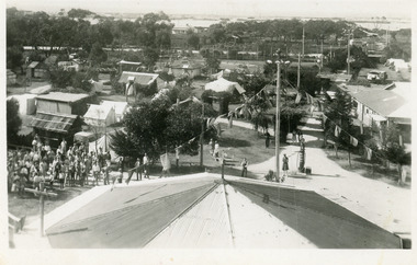
Postcard - Whiter's Camp Park, 1935
... to the main entrance. Lake and hummocks in distance. Cabin, tents... the elevated tankstand looking south to the main entrance. Lake ...Black and white postcard showing an extensive portion of Whiter's Camp Park, taken from the elevated tankstand looking south to the main entrance. Lake and hummocks in distance. Cabin, tents and petrol bowser as well as a crowd of people in image and roof of rotunda directly under photographer. Lakes Entrance Victoriatourism, camping, caravan parks -
 Lakes Entrance Historical Society
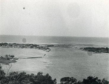
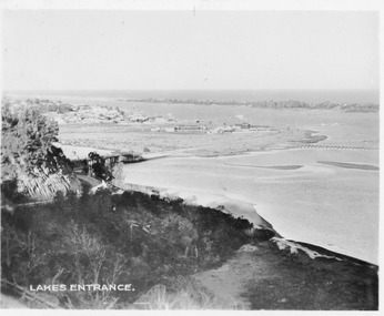
Photograph - The Entrance, 1924c
... at the entrance. Lakes Entrance Victoria... on island, some rock groyne work at the entrance. Lakes Entrance ...Black and white photograph showing view from Jemmys Point of the entrance, with wooden piers, PWD houses and works buildings at New Works. West end of Bullock Island on left side of photo, bathing boxes and some trees on island, some rock groyne work at the entrance. Lakes Entrance Victoriapiers, islands, houses -
 Lakes Entrance Historical Society
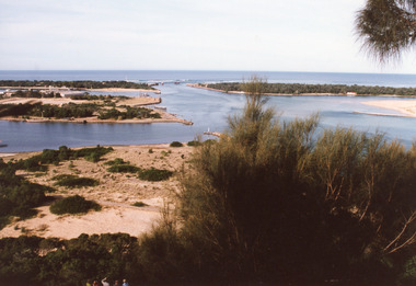
Photograph - The Entrance, 1995c
... years. Two fishing boats in entrance. Lakes Entrance Victoria... operations over many years. Two fishing boats in entrance. Lakes ...Second colour copy as 01601-1 portrait size 15 x 10Colour photograph of the entrance from Bass Strait to the Gippsland Lakes. It shows buildings on Bullock Island including Peck's factory. Western end of Bullock Island and area below Jemmys Point, both made during dredging operations over many years. Two fishing boats in entrance. Lakes Entrance Victoria room display, waterways, topography -
 Lakes Entrance Historical Society
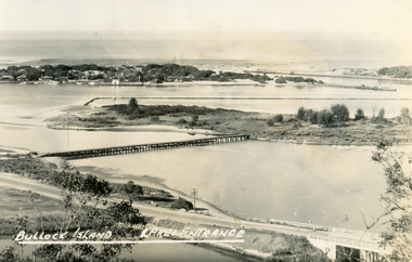
Postcard - Bullock Island, Bulmer H D, 1945
... Black and white postcard of Bullock Island, Lakes Entrance...Bullock Island, Lakes Entrance..., Lakes Entrance Black and white postcard of Bullock Island, Lakes ...Black and white postcard of Bullock Island, Lakes Entrance, showing an extensive rock groyne to the south of the island, into which dredged sand and spoil is to be placed in order to extend the island's area. North Arm bridge, Bullock Island footbridge, New Works settlement and Entrance channel also in image. Lakes Entrance VictoriaBullock Island, Lakes Entranceboats and boating, fishing industry, islands -
 Lakes Entrance Historical Society
Photograph - Golf, Lakes Post Newspaper, 1992
... , Lakes Entrance Associates attending Junior Golf Camp, Lakes... photograph large group adults and children, Lakes Entrance Associates ...number in album 03606.01Black and white photograph large group adults and children, Lakes Entrance Associates attending Junior Golf Camp, Lakes Entrance Golf Club holding banner showing sponsor Heart Health. Lakes Entrance Victoriagolf club, sports -
 Lakes Entrance Historical Society
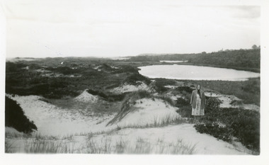
Photograph, 1950c
... to the natural entrance. Lady with shawl in foreground. Lakes Entrance..., the original waterway from the Gippsland lakes to the natural entrance ...Also enlargement 15x25cmBlack and white photograph of the Warm Holes, from the sand hummocks looking west. The Warm Holes are the remnant of Reeves River, the original waterway from the Gippsland lakes to the natural entrance. Lady with shawl in foreground. Lakes Entrance Victoria waterways, topography -
 Lakes Entrance Historical Society
Postcard - View from Jemmys Point, 1930c
... bridge, town of Lakes Entrance, Cunninghame Arm and sand hummocks...Lakes Entrance...Waterways Township Roads and Streets Lakes Entrance Sepia ...Sepia toned small format postcard of a view from Jemmys Point, showing the road cutting around Kalimna Hill, North Arm bridge, town of Lakes Entrance, Cunninghame Arm and sand hummocks, Lakes Entrance VictoriaLakes Entrancewaterways, township, roads and streets -
 Lakes Entrance Historical Society
Photograph - Western Pier
... and shipwreck bell on far right foreground. Lakes Entrance Victoria... foreground. Lakes Entrance Victoria Photograph Western Pier ...Also one black and white copy 9 x 15Sepia photograph showing wooden Western pier at entrance from ocean into the Gippsland Lakes, with dunes in background foreground shows top ridge of roof of rocket shed on left and shipwreck bell on far right foreground. Lakes Entrance Victoriawaterways, piers -
 Orbost & District Historical Society
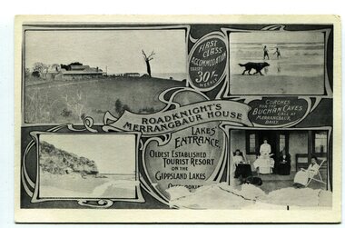
black and white postcard, C1910
... in Lakes Entrance. Merrangbaur was in , Lakes Entrance and stood... of a Lakes Entrance scene in each corner with a banner... in Lakes Entrance. Merrangbaur was in , Lakes Entrance and stood ...This an advertisement / souvenir for Merrangbaur House in Lakes Entrance. Merrangbaur was in , Lakes Entrance and stood on the on the Prince's Highway, about a kilometre from Lakes Entrance. It was destroyed by fire on the early morning of December 15, 1935. The original residence of the Roadknight family, the first white settlers in the Lakes Entrance district, Merrangbaur House had been conducted as a guest house for many years. Much of the furniture was lost, although a portion of the building, consisting of the ballroom and several bedrooms, was saved Mrs. Anne McInnes, aged more than 80 years, the mother of the proprietress, Miss McInnes, was the only guest sleeping in the house when the fire began and had to be assisted from her blazing bedroom on the ground floor. She was carried through a window by members of the fire brigade and spent the remainder of the night at the house of a friend. Miss McInnes was in Melbourne on a business visit arranging for Christmas bookings, when she was informed of her loss. (info. from The Argus Melbourne Monday December 16 1935)This item is associated with tourism in East Gippsland in the early 20th century.A black / white photograph / postcard.There is a photograph of a Lakes Entrance scene in each corner with a banner for "ROADKNIGHT'S MERRANGBAUR HOUSE' in the middle.In a circle is "FIRST CLASS ACCOMMODATION TARIFF 30/- WEEKLY". It has a note that "Coaches for Buchan Caves call at Merrangbaur daily".merrangbaur-lakes-entrance roadknight-lakes-entrance postcard-lakes-entrance -
 Lakes Entrance Historical Society
Photograph - Lakes Entrance, Gippsland Ports, 2006 c
... Point hill into township of Lakes Entrance Victoria... photograph of entrance from Bass Strait to Gippsland Lakes including ...Second copyColour aerial photograph of entrance from Bass Strait to Gippsland Lakes including Bullock Island Reeves Channel Rigby Island houses on Kalimna Hill and Princes Highway winding down Jemmys Point hill into township of Lakes Entrance Victoriaaerial photograph, ocean, waterways -
 Lakes Entrance Historical Society
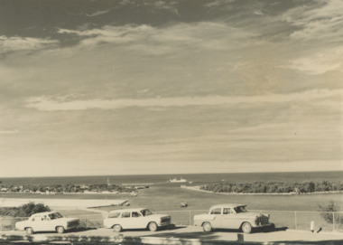
Photograph - Views from Jemmys Point, Lakes Entrance c1960, 1960 c
... Flinders working outside the entrance Lakes Entrance Victoria... working outside the entrance Lakes Entrance Victoria. Also two ...Black and white photograph of the entrance taken from a bend in the Princes Highway showing three cars parked at the viewing area beside the highway. Boat and dredge in waterway below highway dredged sand in Bullock Island extension, dredge Mathew Flinders working outside the entrance Lakes Entrance Victoria. Also two black and white photographs taken of Entrance from Jemmys Point taken 1960 c waterways, vehicles, islands, roads and streets -
 Lakes Entrance Historical Society
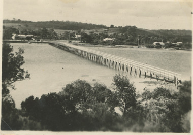
Postcard - Cunninghame Arm footbridge Lakes Entrance Victoria, H D Bulmer, 1940
... houses of Lakes Entrance Victoria Stamp on back The Lakes Studio... of the sand dunes looking towards the few houses of Lakes Entrance ...Also two black and white postcards looking across footbridge to township 04271.1, 04271.2 size 9.5 x 14 cm 1940 cBlack and white postcard of Cunninghame Arm footbridge taken from the top of the sand dunes looking towards the few houses of Lakes Entrance Victoria Stamp on back The Lakes Studio Lakes Entrance. Also two black and white postcards looking across footbridge to township 04271.1, 04271.2 size 9.5 x 14 cm 1940 cbridges, recreational facilities, surf lifesaving, waterfront -
 The Beechworth Burke Museum
Photograph - Photograph - Reproduction, 1890-1900
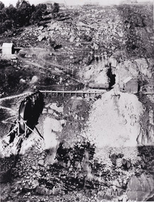
The photograph appears to depict the of the entrance to the Rocky Mountain Tunnel. The Rocky Mountain Tunnel runs from opening of the tunnel, underneath the Beechworth town, to the Gorge. This tunnel drained the excess water from the upper Spring Creek Goldfield to allow for mining access in the area. The Rocky Mountain Co. blasted through the granite rock to create the original 400ft-long tunnel in 1859, but between 1867 and 1871, the Rocky Mountain Gold Sluicing Co. widened and extended it. At its completion, it measured 14ft deep, 6ft wide, and almost half a mile long. The mining surveyor at Beechworth called it 'without doubt, the greatest undertaking of the kind in the colony'. When the company became the Rocky Mountain Extended Gold Sluicing Co. in the mid-1870s, they continued the tunnelling work. The work was reportedly vital to mining being able to continue at Beechworth and may have established world records in tunnelling through hard rock. The entrance at the Gorge side of the tunnel can be seen from the Beechworth Gorge Walk. The tunnel continues to be an outfall drain for the lake and the town.The search for gold is ingrained into the history of Victoria and therefore, images like this one which portray an open cut sluicing site can reveal important information for society and technology for the date when the photograph was taken. This image is of important historical significance for its ability to convey information about sluicing and the methods used to find gold in the late 1800s and early 1900s. It also shows a location where sluicing was undertook which provides insight into the impact of sluicing on the environment at a time when it was done. The Burke Museum is home to a substantial collection of Australian mining photographs which can be used to gain a deeper understanding into life on the gold fields, technology used in mining, the miners themselves and the impact of the gold digging on the environment.A black and white rectangular reproduced photograph printed on matte photographic paper.7814beechworth, beechworth museum, burke museum, australian museum, mining, rocky mountain mining co., rocky mountain mining company, mine, mining company, rocky mountain mine, mine entrance, rocky mountain, gold, gold mining -
 Orbost & District Historical Society
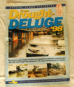
pictorial magazine, From Drought to Deluge '98, 1998
... . Photos are black and white. They are of Bairnsdale, Orbost, Lakes.... Photos are black and white. They are of Bairnsdale, Orbost, Lakes ...This magazine cost $2.50 and was produced to support the East Gippsland Red Cross Flood Appeal. Following heavy rain in East Gippsland in June, 1998, major flooding occurred in the Mitchell, Nicholson, Tambo, Snowy, Brodribb and Bemm Rivers. Other streams in the region also experienced high flows during this time. Probably the most severe direct impacts of the floods were to the rural sector.This magazine is a contemporary record of a significant local event.Two copies of a magazine pictorial of the floods of 1998. Photos are black and white. They are of Bairnsdale, Orbost, Lakes Entrance, Raymond Island, Bemm River, Bruthen , Tambo and Cabbage Tree. flood-1998 flood-east gippsland disaster-floods -
 Orbost & District Historical Society
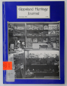
journals, Gippsland Heritage Journal, June 1995
... of a shop at Lakes Entrance, East Gippsland. The shop is Bulmers...-Heritage-Journal history-East-Gippsland history-Lakes-Entrance ...This issue was edited by Meredith Fletcher. This magazine is a useful reference on the history of East Gippsland. A plastic-covered ,64 pp magazine, titled, Gippsland Heritage Journal. It has a dark blue cover with a b/w photograph of a shop at Lakes Entrance, East Gippsland. The shop is Bulmers Gift Salon. The cost of the journal is $7.50. It contains photographs and article on the history of East Gippsland.gippsland-heritage-journal history-east-gippsland history-lakes-entrance -
 Orbost & District Historical Society
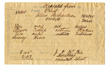
telegram, April 1899
... River Lakes Entrance. It was logged at 2:45 and received at 2:47.... to the Snowy River Lakes Entrance. It was logged at 2:45 and received ...This message concerned the P.S. Curlip's entry to the Snowy River Lakes Entrance. It was logged at 2:45 and received at 2:47.This item is associated with the P.S. Curlip and the Richardson family, early Orbost pioneers.A white paper telegram with blue print and details hand-written in black ink. It has been sent fro Orbost to "Allen Richardson Marlo". The handwritten message is difficult to decipher."You may enter - engine driver Curlip within two miles outside Entrance Snowy River."telegram-richardson-curlip communications-19th-century -
 Orbost & District Historical Society
black and white photograph, late 19th century / early 20th century
The first settler to occupy the Marlo township area was James Stirling around the year 1875. He built a bark hut on the bluff that had two rooms, bark walls, earthen floors and a shingle roof. By 1884, this structure had expanded to a 9 roomed accommodation house and in 1886 became the Marlo Hotel when a liquor license was granted. The Governor-in-Council declared Marlo to be a township on 18 February 1889. During May 1889, the government surveyor, E.L. Bruce set out 19 sections of the new township, with the first sales of subdivided land occurring the following May. At this time, Stirling's Marlo Hotel was the unofficial hub for the community. It was a general store, accommodation house and the unofficial post office, with settlers taking turns in bringing the mail from Orbost or Cunningham. This continued until Aug 1942, and in 1969 was located in a house adjacent to the Marlo Hotel, before being transferred to the Marlo General Store in this year. The official Post Office List states the Marlo Post Office opened around 1902. in 1925, the "Marlo House" (a nine room accommodation guest house) was granted a liquor licence. The "Marlo House" became "The Marlo Hotel". The Marlo Hotel was popular with many Orbost and district settlers, who travelled to Marlo by horseback or buggy. In the early 20th century the hotel advertised itself as " Under Vice-Regal Patronage. Situated on High Cliff, fronting Ocean, Lakes and Snowy River. Those in search of Health, Rest and Sport should visit Marlo. Boating, Fishing, Shooting, Bathing, Golf. Comfort and Convenience at Marlo Hotel, near Orbost, East Gippsland. Nixon's Cars would meet the train at at Orbost. Fare---6s single, 12s return. Telephone No. 1, Marlo. S, P, STEWART, Proprietor." The Marlo Hotel, perched on the hill overlooking the estuaries and the entrance is a significant building in Marlo. Established in 1886, it has been operating for over 120 yearsAn original black / white photograph and a black / white copy of a party being held under trees on the lawn of the Marlo Hotel. It is a postcard with advertising of Marlo on the back.on back - "Where to spend your holiday - Marlo" on front - "Vice Regal Party at Hotel, Marlo"marlo-hotel -
 Orbost & District Historical Society
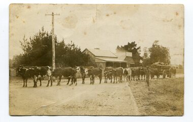
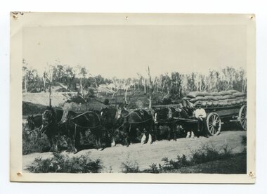
black and white photograph, 1911
... it to the fisherman's Wharf in Lakes Entrance. Maize has been grown...on back - " Carting maize to Lakes Entrance in 1911."... it to the fisherman's Wharf in Lakes Entrance. Maize has been grown ...This photo shows Jas Lynn of Orbost driving a team of bullocks pulling a large cart of maize. They are taking it to the fisherman's Wharf in Lakes Entrance. Maize has been grown on the Orbost flats since the late 19th century. Transport was always an obstacle to economic sucess. For a few years prior to the First World War and the construction of the railway line from Bairnsdale to Orbost, a lot of maize was carted by horse and bullock teams to Lakes Entrance for transhipment to the Melbourne market. At that .time yields of 90 to 100 bushels of maize were quite a common occurrence. James Lynn, a member of the East Gippsland Maize Board, farmed at Jarrahmond.This photograph is associated with the large maize growing industry in the Orbost region. A black / white photograph of a bullock team pulling a large, loaded cart. It is being driven by a man standing on the side of the road, holding a whip. In the background are houses and a telegraph pole.on back - " Carting maize to Lakes Entrance in 1911."transport-bullocks maize-orbost lynn-james -
 Orbost & District Historical Society
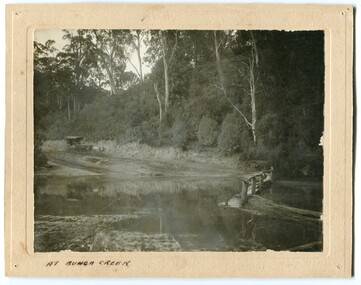
black and white photograph, late 19th - early 20th century?
... Bunga Creek is approximately 5km east of Lakes Entrance.... gippsland Bunga Creek is approximately 5km east of Lakes Entrance ...Bunga Creek is approximately 5km east of Lakes Entrance.This is a pictorial record of horse-drawn transport of the late 19th century used in East Gippsland.A black / white photograph of a bush scene with a horse - drawn coach running along a track beside a creek.. It is on a cream coloured buff card.on back - "No. 5" on front - "At Bunga Creek"bunga-creek horse-drawn-coach -
 Orbost & District Historical Society
black and white photograph, before 1924
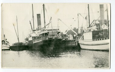
... , Lakes Entrance, The Lady Harriett was a small steamer..., Lakes Entrance, The Lady Harriett was a small steamer ...This photograph shows the Lady Harriett, her barge, the Wyrallah and Storm Bird with Captain Jimmy Bills at Harbeck's wharf, Lakes Entrance, The Lady Harriett was a small steamer that serviced the Tambo River and other areas. In 1895 the Lady Harriett was advertised to run between Bairnsdale and Mallacoota on a weekly service. The Lady Harriett and barge did two or three trips up the Tambo per week. She did not carry passengers or run to a timetable and would carry maize and beans as well as fish from Mallacoota where by 1900 the fishing industry was well established' Lady Harriett towed her barge carrying an assortment of goods up the Tambo from 1895 to 1913. The S.S. Wyrallah was a regular Melbourne header for over twenty years. She was run down and sunk by the steamer Dilkera with the loss of six lives at Port Philip Head. (ref. The Argus Friday April 11 1924)This is a pictorial record of a once busy wharf. From Lakes Entrance ocean-going vessels had access to the Gippsland Lakes, the largest navigable inland waterway in Australia.A large black / white photograph of two large ships and two smaller ones at a wharf. There are people on the wharf and on the boats.on back - "Jo-Bull", L-R Lady Harriet.........."lady-harriett s.s.-wyrallah shipping-east-gippsland harbeck's-wharf-lakes-entrance sea-transport -
 Orbost & District Historical Society
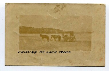
black and white photograph, late 19th - early 20th century
... . As the settlement grew, a weekly mail service from Cunninghame (Lakes.... As the settlement grew, a weekly mail service from Cunninghame (Lakes ...In the late 19th century in the Orbost area roads were just bush tracks which generally were unsuitable for any type of vehicular traffic so were traversed mainly by horseback. As the settlement grew, a weekly mail service from Cunninghame (Lakes Entrance) was estab-lished. The settlers had to carry the mail for three months and each took a turn as mailman during that time. The first coach was driven by Mr Alex Hall. Eventually a daily mail service was set up and many drivers included B. Sutherland, W. Middleton, Jonson Bros., J. Mitchell, F. Newport, J. Geddes, A. Coulson, Bert Cessor, H. Weekes and A. Barthile. (info. from Newletter August 2007) This photograph is one of A. Coulson’s Coach crossing the Sand Bar at Lake Tyers.This is a pictorial record of very early transport in East Gippsland.A very faded small postcard / photograph of a horse and cart crossing a beach.on front in black writing - " Crossing at Lake Tyers" on back - "A Coulson"lake-tyers transport coulson-coaches -
 Orbost & District Historical Society
black and white photograph, Vogt, Stanley, 1918
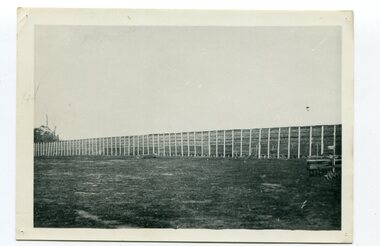
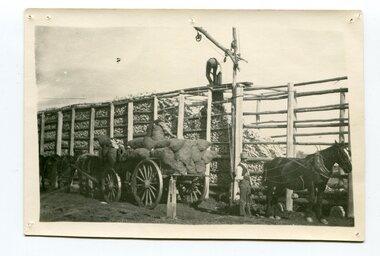
... it was loaded onto river boats to Lakes Entrance, and then by ocean... it was loaded onto river boats to Lakes Entrance, and then by ocean ...Maize,has been grown on the Orbost flats for at least 70 years. When early settlers began to arrive on the Snowy River somewhere in the 1880s, the land was mostly swamps and heavily timbered jungle on the river frontages. The swamps were drained, bit by bit, by men with short handled shovels and working in mud and water. The frontages were cleared by axe and shovel and fire. Several kinds of crops were experimented with such as hops, hemp and maize, the latter grew particularly well and became the main crop of district. The problem then was to thresh and deliver the product to the market. A small single cob machine was brought here and one man turned the handle, while the boy or Mum fed the cobs singly into the machine. A good day’s work would thresh about 50 bushels or about 12 bags (4 bushels). The task then was to cart the maize to market. For a few years this was done by horses and dray carrying about 60 bushels to Mossiface, where it was loaded onto river boats to Lakes Entrance, and then by ocean boats to Melbourne. Later it was taken to Bairnsdale by foot and loaded onto the trains to Melbourne. (more information in Newsletter October 2006) This crib, measuring seven chains, sixteen feet, contained 10,000 bags of maize cobs which were grown by Linc Timmons on Peter Irvine's farm (Fairlea?) in Orbost, East Gippsland. The growing of maize in the Orbost district contributed significantly to the economy of the township for many years, The many maize cribs once seen on the surrounding farms have now disappeared and this photograph is a pictorial record of that significance.A black / white photograph of a large maize crib full of maize in a paddock. There is a large framed copy of the original.agriculture-orbost farming-maize-orbost maize-crib-orbost -
 Orbost & District Historical Society
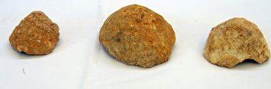
fossils
... (near Lakes Entrance in East Gippsland).... Arm (near Lakes Entrance in East Gippsland). fossils coral ...Inspected by George Rawlings 6.2.2012. Found at Toorloo Arm (near Lakes Entrance in East Gippsland).Three bowl-shaped fossils from the Miocene Era. They are Bryzoan types of coral. .1 is part of a shell. .2 is a cup coral and .3 is a coral.fossils coral miocene bryzoan -
 Orbost & District Historical Society
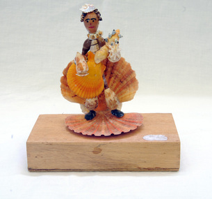
shell ornament, c. early to mid 20th Century
... and is presently (2013) in care at Lakes Entrance. Elma's hobby... away and is presently (2013) in care at Lakes Entrance. Elma's ...Mrs Elma Camm (nee Freeman) was the wife of Herbert Desmond Camm. Des and Elma lived in Orbost from 1971-1980/1. Des died on 9/11/1980 and is buried in Orbost Cemetery. Elma moved away and is presently (2013) in care at Lakes Entrance. Elma's hobby was collecting shells and crafting them into interesting forms. Much of her work is in the Shell Museum in Lakes Entrance. The figurine in Orbost Museum was donated by Elma.This item is an example of the handcraft skills of women in the early to mid 20th century.A small figurine made completely of different shaped shells and set onto a wooden block as its base. The block was originally a Wee William cigar box. The figure is playing a stringed instrument, possibly a guitar, held in front of him/her. The hat is a small shell.shell-art figurine recycled-materials -
 Orbost & District Historical Society
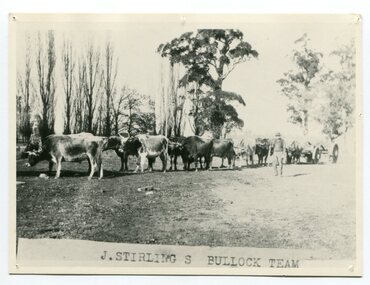
black and white photograph, late 19th century - early 20th century
... goldfields, Cunninghame, (now Lakes Entrance), then to the Old... goldfields, Cunninghame, (now Lakes Entrance), then to the Old ...Aged 19 James Stirling arrived in Melbourne on January 26, 1842 with his family - parents, three sisters and two brothers. James Stirling moved around a lot to Whittlesea, Ballarat goldfields, Cunninghame, (now Lakes Entrance), then to the Old Station about 36 miles to the east along the coast near the mouth of the Snowy River and for a time settled there with his wife also from Wigton, Scotland, and their family four sons two daughters (James, John, William, George, Margaret and Polly). The first settler to occupy the Marlo township area was James Stirling around the year 1875. He built a bark hut on the bluff that had two rooms, bark walls, earthen floors and a shingle roof. By 1884, this structure had expanded to a 9 roomed accommodation house and in 1886 became the Marlo Hotel when a liquor license was granted. (more information from “Snowy River Mail”, Wednesday, April 13th 1977: MEMORIES OF MARLO by Mrs Elsbeth Conlon (nee Stirling ) During the 19th century bullock teams were the most effective means of transporting people and goods inland, as the roads were badly made and in poor condition. The better roads were closer to the towns, and the further away from the town, the worse the conditions of the roads. Bullock teams drew heavily laden carts full of provisions, equipment and people from town to town and into the countryside to isolated homes. This item is associated with that era. It is also associated with James Sterling a very early settler of Marlo.A black / white photograph of a bullock team with a man standing beside it.on front - J STIRLING S BULLOCK TEAMstirling-james marlo-history bullock-team transport -
 Orbost & District Historical Society
black and white photograph
... it was loaded onto river boats to Lakes Entrance, and then by ocean... it was loaded onto river boats to Lakes Entrance, and then by ocean ...Maize,has been grown on the Orbost flats for at least 70 years. When early settlers began to arrive on the Snowy River somewhere in the 1880s, the land was mostly swamps and heavily timbered jungle on the river frontages. The swamps were drained, bit by bit, by men with short handled shovels and working in mud and water. The frontages were cleared by axe and shovel and fire. Several kinds of crops were experimented with such as hops, hemp and maize, the latter grew particularly well and became the main crop of district. The problem then was to thresh and deliver the product to the market. A small single cob machine was brought here and one man turned the handle, while the boy or Mum fed the cobs singly into the machine. A good day’s work would thresh about 50 bushels or about 12 bags (4 bushels). The task then was to cart the maize to market. For a few years this was done by horses and dray carrying about 60 bushels to Mossiface, where it was loaded onto river boats to Lakes Entrance, and then by ocean boats to Melbourne. Later it was taken to Bairnsdale by foot and loaded onto the trains to Melbourne. (more information in Newsletter October 2006)The growing of maize in the Orbost district contributed significantly to the economy of the township for many years, The many maize cribs once seen on the surrounding farms have now disappeared and this photograph is a pictorial record of that significance.A black / white photograph of a man unloading maize from a horse-drawn wagon into a maize crib. Another man is standing by the horse.maize-crib-orbost agriculture maize-corn-orbost -
 Orbost & District Historical Society
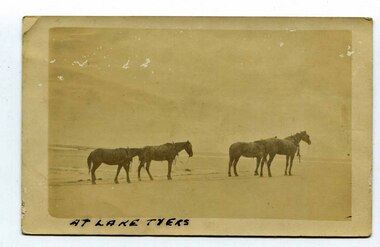
black and white photograph, late 19th century - early 20th century
... . As the settlement grew, a weekly mail service from Cunninghame (Lakes.... As the settlement grew, a weekly mail service from Cunninghame (Lakes ...In the late 19th century in the Orbost area roads were just bush tracks which generally were unsuitable for any type of vehicular traffic so were traversed mainly by horseback. As the settlement grew, a weekly mail service from Cunninghame (Lakes Entrance) was estab-lished. The settlers had to carry the mail for three months and each took a turn as mailman during that time. The first coach was driven by Mr Alex Hall. Eventually a daily mail service was set up and many drivers included B. Sutherland, W. Middleton, Jonson Bros., J. Mitchell, F. Newport, J. Geddes, A. Coulson, Bert Cessor, H. Weekes and A. Barthile. (info. from Newletter August 2007) This photograph is one of A. Coulson’s Coach crossing the Sand Bar at Lake Tyers.This is associated with early transport in East Gippsland.A black / white postcard photograph of four horses alone on a beach.on front - At Lake Tyers on back - "Mr A. Coulson, coach driver, Orbost"lake-tyers coulson-coach-driver transport-horse-drawn -
 Orbost & District Historical Society
black and white photograph, late 19th century - early 20th century
... it was loaded onto river boats to Lakes Entrance, and then by ocean... it was loaded onto river boats to Lakes Entrance, and then by ocean ...Maize, or corn as it is called in America and New South Wales, has been grown on the Orbost flats for at least 70 years. When early settlers began to arrive on the Snowy River somewhere in the 1880s, the land was mostly swamps and heavily timbered jungle on the river frontages. The swamps were drained, bit by bit, by stout hearted men with short handled shovels and working in mud and water. The frontages were cleared by axe and shovel and fire. Several kinds of crops were experimented with such as hops, hemp and maize, the latter grew particularly well and became the main crop of district. The problem then was to thresh and deliver the product to the market. A small single cob machine was brought here and one man turned the handle, while the boy or Mum fed the cobs singly into the machine. A good day’s work would thresh about 50 bushels or about 12 bags (4 bushels). The task then was to cart the maize to market. For a few years this was done by horses and dray carrying about 60 bushels to Mossiface, where it was loaded onto river boats to Lakes Entrance, and then by ocean boats to Melbourne. ( from NEWSLETTER OCTOBER, 2006) This is a pictorial record of farming practices in Orbost in the early 20th century.A black / white photograph of a horse team hauling a wagon loaded with bags of maize.A man is sitting on the edge of the wagon.farming-orbost agriculture maize corn transport -
 Orbost & District Historical Society
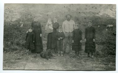
black and white photograph, 1994
... is now known as the Old Station In 1850. The Lakes Entrance run... is now known as the Old Station In 1850. The Lakes Entrance run ...The Roadknight family settled on Ewing's Marsh on what is now known as the Old Station In 1850. The Lakes Entrance run was occupied by the late Thomas Roadknight. In 1852 his brother William took charge. Soon after this Corringle Station was occupied by the late T. T. Stirling. William was born at Collingwood, the son of William Roadknight and Jane Stirling. The Roadknight family came from Colac on board the Enterprise to their new home at Cunninghame. The house on the hill, now Pine Hill was named Merrangbaur (home of the lyrebird). William held the Lake Tyers and Snowy River run in partnership with Thomas Telfer Stirling who took up the eastern end of the run on the west bank of the Snowy River. The run included Ewing‟s Marsh — the Ewing brothers were earlier landowners but had no formal run in this area. William served four terms on the Tambo Shire Council as a representative of the Bendoc Riding despite not being a resident of the Riding. He was then elected to the Orbost Shire as a West Riding councillor in 1896-97, 1897-98 and was Shire President in his final year 1898-99 This item is associated with Roadknight family who were early settlers in the Orbost district.A black / white photograph of a family group of mother, father and six children standing outdoor. There is a dog lying in front .roadknight-william ewing's-marsh old-station-orbost -
 Orbost & District Historical Society
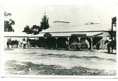
black and white photograph, early 20th century
... changed to Lakes Entrance in 1915.... changed to Lakes Entrance in 1915. This is a pictorial record ...This photograph shows the Orbost - Cunninghame coach leaving from outside Dickson's Hotel in Nicholson Street Orbost. Although noted as the Dickson Hotel, this may have been the Commonwealth Hotel which opened on New Year's Day 1902. Mr Jasper Drew held the first licence. Laura Dixon held the hotel licence from 04/04/10 until 05/02/17 and during that time it was known as Dickson's Hotel. A township, known as Cunninghame after a pioneer Gippsland squatter, was surveyed near Lake Bunga in 1866. The name changed to Lakes Entrance in 1915.This is a pictorial record of horse-drawn transport commonly used in Orbost, early 19th century. It also shows the Commonwealth Hotel before the second storey was added.A black / white photograph of a large single-storey building with a horse drawn coach and seneral people and horses standing nearby. The road is unsealed. On the side of the carriage is "CUNNINGHAME".transport-horse-drawn dickson's-hotel commonwealth-hotel cunninghame