Showing 640 items
matching footpaths
-
 Glen Eira Historical Society
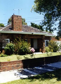
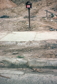
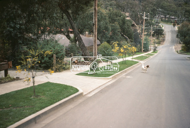
Photograph, Lindsay Avenue, 42, Murrumbeena, 2001
Originally labelled "Beauville Estate, Established 1936, Still Thriving 65 years on, 10th March 2001", the Beauville Estate Album contains colour photographs of houses in the Estate. They were taken around the time of the Beauville Estate’s 65th Heritage Celebration held on 10/03/2001 and donated to the Caulfield Historical Society shortly afterwards. Photographer unknown. City of Glen Eira’s Heritage Management Plan Vol 2 p79 (this is p84 of the pdf version) – HO12 Beauville Estate and environs, Murrumbeena: The Beauville Historic Area is important at the State level as the first large housing estate undertaken by the AV Jennings Construction Co, later Jennings Group Limited, Victoria’s largest home builder. It is important also as a very early estate development incorporating a range of features other than houses and including made roads, shops and recreation facilities. In this respect it was the forerunner of the comprehensively planned housing estate of the post war era. The estate is distinguished by its aesthetic values, as is the earlier and comparable Hillcrest Estate, which are formed by a combination of restrained diversity in house styles, with the exception of no. 30 in the emerging International style, and by a landscaped garden environment. Colour photograph of an unpainted variegated brown brick house. Other features include an open porch with 2 brick pillars and white trellis on one wall, tiled roof, white sash windows, feature brick wide and tall chimney and low unpainted brick fence and brick garage with white door. A public footpath and nature strip are in the foreground.42murrumbeena, houses, architectural styles, 1930's, inter war style, a.v. jennings, av jennings, jennings, brick houses, beauville estate, porches, lindsay avenue, sir albert victor jennings, a v jennings construction co, beauville estate heritage area, glen eira city council, architectural features, jennings group limited, land subdivision, gardens, beauville historic area, brick features, chimneys, sash windows, garages (private), brick fences -
 Port Melbourne Historical & Preservation Society
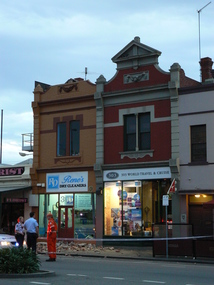
Photograph - Partial collapse, Rene's Dry Cleaners, Bay Street, Port Melbourne, David Thompsom, 21 Oct 2007
Eight colour photos taken 21 October 2007 showing emergency services and Police in attendance outside Rene's Dry Cleaners at 301 Bay Street. The top structure of the building had collapsed and fallen onto the footpath in the late afternoon or early evening. The Florist at 299 Bay St and 303 World Travel & Cruise on either side appear undamaged.business and traders, engineering, rene's dry cleaners, florist, 33 world travel & cruise -
 Ballarat Tramway Museum
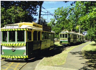
Postcard, Ballarat Tramway Museum (BTM), BTM Trams on access track, 2014
Postcard of BTM trams on the access track taken during 2014. No. 14 parked by footpath at the east end of the access track, then No. 40 and 38. Printed in Ballarat by???. On the rear has the words "Ballarat Tramway Museum / Limited Edition 1/50, c BTM 2014" Has a divided back with a 8mm thick black line on the right hand side.trams, tramways, btm, access track, wendouree parade, tram 14 -
 Whitehorse Historical Society Inc.
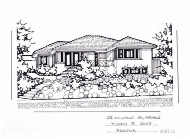
Artwork, other - Ink Line Drawing, Margaret Picken, 125 Jolimont Rd., Vermont, 2003
A property illustration by Margaret Picken Commissioned by a real estate agency for the purpose of advertising 125 Jolimont Rd., Vermont This property is listed as having sold for $351,000 in 2003 Made by using Rotring ‘Rapidigraph’ drafting pens with Rotring ink on Rapidigraph polyester drafting film, double matte. Trained as a cartographic draftsman within the mining industry, Margaret Picken is an artist who worked producing property illustrations for real estate agencies in eastern suburbs of Victoria from 1983-2005. Retiring from the industry as technological changes favored coloured photography over illustrations, and commissioning companies over sole contractors.This artwork is of Historical Significance as a record of local domestic architecture.A black ink line drawing on drafters film by Margaret Picken, of a black and white line drawing of a single story brick house, with steps from the footpath leading up to a raised porch. In the foreground is a stone retaining fence enclosing a front yard with garden bed edging. There are two hole punch holes just below centre of the upper edge125 Jolimont Rd., Vermont Picken © 2003 Realtorwhitehorse historical society, schwerkolt cottage, housing, architecture, margaret picken, house, garden, real estate, vermont, vermont south -
 Glenelg Shire Council Cultural Collection
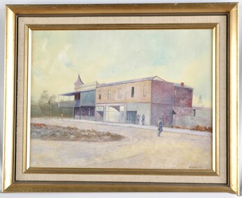
Painting, Down the Street, 1977
UnknownView of a building on a country street. The building is large, and in 3 sections, two of which may be shops. The building on the corner has a verandah and balcony over the footpath, and may be a pub. Two people lean on the wall to the right of the building. One man in overalls and carrying a bag walks along the centre of the dirt road. Framed in gold painted wooden frame.Front: B Malloch '77 (lower left) (brown paint) Back: 1977 - (yellow sticker, upper right) Mer-ger Galleries, Picture Framing sticker, order no. 1057 (sticker, lower centre) "Dow...E Street" (blue pen on sticker, lower left, torn) -
 Phillip Island and District Historical Society Inc.
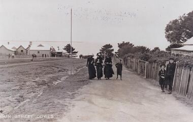
Photograph, Cowes Phillip Island, 1920
A stretch of the main Street of Cowes, looking towards Westernport Bay. A narrow strip of the Peninsula in the background. Left side of road depicts a group of buildings and Post Office. A Norfolk Pine in the background. On right side of road on footpath are three women and a child. The women are attired in long black dresses and large smart hats. Along side them is a picket fence, shrubby garden and a house. A small child and male figure popping out the gate.Thompson Avenue, CowesMain Street Coweslocal history, photographs, streetscape, cowes, black & white photograph, mary robb -
 Stawell Historical Society Inc
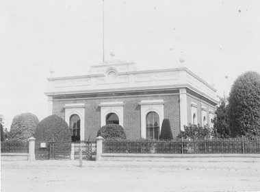
Photograph, Stawell Shire Hall 1866
Stawell Shire Hall built 1866 Hewitt Photo. A professional photograph of the Shire Hall showing the road and footpath in front of the building. The view shows three side windows and two at the front opf the building with four urn shaped decorations on top of the building. A flag post can be seen behind the central building decoration on the roof above the entrance doorway. The landscape around the building is well manicured with tall to medium sized shrubs. Stawell Shire Hall built 1866. Black & white photograph showing a front and side view of the building. This photo shows three side windows compared to an earlier photo, 84.2 where only one side window can be seen.Stawell Photographic Co. Close Railway Station C. HEWITT, Managerstawell -
 Eltham District Historical Society Inc
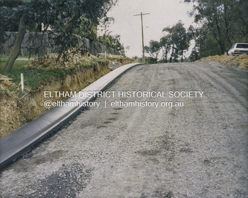
Photograph - Colour Print, Shire of Eltham, Bolton Street, Eltham, just north of Sackville Street intersection, c.1983
A single rollover kerb has just been laid on western side cut into the embankment. At the crest of the hill on right in front of the Ford Laser is a fire hyrdant. This photo was processed at the same time as image EDHS_07261 of roadworks in Sackville Street about 200 m away which has been dated as c.1983 (between Sep 1982 and May 1983). The paling fence on the left has a change of angle just before the crest of the hill then flattens. More recent Google Streetviews show the same fence and shape and in more recent times a new fence but same shape. Google Streetview for Jan 2008 indicates a more recent road widening and new profile kerb and channel. The embankment was further cut away and the footpath that was adjacent to the fence lowered to road level. The fire hydrant that was on the right hand side has been relocated to the left next to the footpath. Significantly more electrical wires are now strung on the telephone poles. In 2017 Bolton Street was again upgraded. The fire hyrdrant was then relocated to another (unknown) location.1983, footpaths and gutters, road construction, road drainage, road sealing, bolton street, eltham, sackville street -
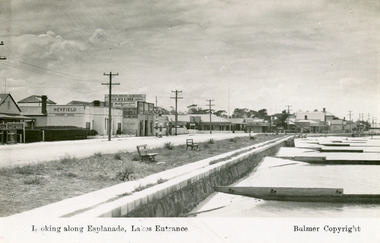 Lakes Entrance Historical Society
Postcard - Lakes Entrance, Bulmer H D, 1940c
Black and white postcard of Esplanade, showing timber sand groynes, rock wall, concrete footpath along the foreshore. Across the highway from left to right Kia-Ora House, Heyfield House, Coates Bros Garage, Robin Hood Inn, Vises Cafe, Methodist Church, Bellevue Guesthouse, Police Station, Maranui Guesthouse and Glenara Guesthouse. Lakes Entrance VictoriaLooking Along The Esplanade Lakes Entrancewaterfront, township, accommodation -
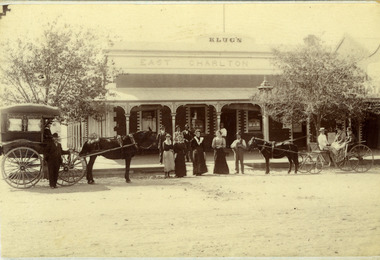 Charlton Golden Grains Museum Inc
Photograph, Clarke Bros Photographers, Klug's East Charlton Hotel c. 1892, c.1892
East Charlton Hotel High St Charlton c. 1892. Proprietor C. Klug. Established by John Flug who built Charlton's first commercial building in 1875 - a slab and bark inn 100 metres to the rear of this building. Photo taken by Clark Bros, Windsor, MelbourneBlack & white photo, mounted, postcard size. Signage Klug's on top of the building, East Charlton Hotel below that. Four men standing on footpath, four women and a man holding a dog standing on the road. On the left is a horse and covered buggy with a man standing in front of the buggy. There is a boy sitting in the buggy holding the reins. On the right is an open gig with a man and two women in it.c. klug, john flug, clark bros, east charlton hotel, business, industry -
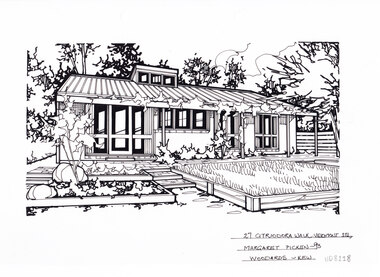 Whitehorse Historical Society Inc.
Artwork, other - Ink Line Drawing, Margaret Picken, 27 Citriodora Walk., Vermont South, 1993
A property illustration by Margaret Picken Commissioned by a real estate agency for the purpose of advertising 27 Citriodora Walk., Vermont South This property is listed as having sold for $157,000 in 1993 Made by using Rotring ‘Rapidigraph’ drafting pens with Rotring ink on Rapidigraph polyester drafting film, double matte. Trained as a cartographic draftsman within the mining industry, Margaret Picken is an artist who worked producing property illustrations for real estate agencies in eastern suburbs of Victoria from 1983-2005. Retiring from the industry as technological changes favored coloured photography over illustrations, and commissioning companies over sole contractors.This artwork is of Historical Significance as a record of local domestic architecture.A black ink line drawing on drafters film by Margaret Picken, of a black and white line drawing of a single story brick house with a concrete footpath in front and along the right hand side leading to a back gate in the background. There is greenery along long the left, right and bottom edges of the drawing. There are two hole punch holes just below centre of the upper edge27 Citriodora Walk., Vermont South Margaret Picken - 93 Woodards - Kewwhitehorse historical society, schwerkolt cottage, housing, architecture, margaret picken, house, garden, real estate, vermont, vermont south -
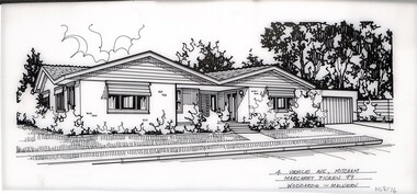 Whitehorse Historical Society Inc.
Artwork, other - Ink Line Drawing, Margaret Picken, 4 Venice Ave., Mitcham, 1989
A property illustration by Margaret Picken Commissioned by a real estate agency for the purpose of advertising 4 Venice Ave., Mitcham. This property is listed as having sold for $169,000 in 1990 Made by using Rotring ‘Rapidigraph’ drafting pens with Rotring ink on Rapidigraph polyester drafting film, double matte. Trained as a cartographic draftsman within the mining industry, Margaret Picken is an artist who worked producing property illustrations for real estate agencies in eastern suburbs of Victoria from 1983-2005. Retiring from the industry as technological changes favored coloured photography over illustrations, and commissioning companies over sole contractors.This artwork is of Historical Significance as a record of local domestic architecture.A black ink line drawing on drafters film by Margaret Picken, of a single story brick house, with a driveway leading toa connected garage on the right. A footpath leads up to an enclosed portico and front door. Garden beds edge the sides of the house, set back from a small front lawn. There are two hole punch holes centered along the upper edge1 Paranda Crt., Vermont Marg. Picken '89 Woodards - Malvernwhitehorse historical society, schwerkolt cottage, housing, architecture, margaret picken, house, garden, real estate, mitcham, malvern -
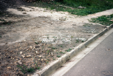
 Eltham District Historical Society Inc
Photograph, Kerb and channeling works, Beard Street and Main Road, Eltham, 3 Sep 1981
Roll of film taken by Eltham Shire Council officers of roads and houses in the Eltham East area, 3 September 1981 prior to construction of new water main; including views of existing damage to footpaths and gutters and general views of Beard Street. These images provide a perspective of housing estate developments and changes in housing styles and road development which began sweeping in from the mid 1970s with increasing urbanisation of what was once more outlying suburbs and regions.35mm colour positive transparency (1 of 28) Mount - Kodak Kodachrome Cardbeard street, eltham, footpaths and gutters, infrastructure, roads, main road -
 Eltham District Historical Society Inc
Photograph, Beard Street, Eltham, 3 Sep 1981
Roll of film taken by Eltham Shire Council officers of roads and houses in the Eltham East area, 3 September 1981 prior to construction of new water main; including views of existing damage to footpaths and gutters and general views of Beard Street. These images provide a perspective of housing estate developments and changes in housing styles and road development which began sweeping in from the mid 1970s with increasing urbanisation of what was once more outlying suburbs and regions.35mm colour positive transparency (1 of 28) Mount - Kodak Kodachrome Cardbeard street, eltham, infrastructure, roads, horse, park road -
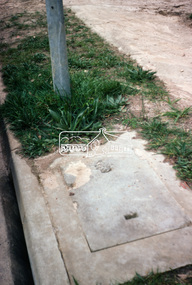
 Eltham District Historical Society Inc
Photograph, Foothpath and kerb damage, Bainbridge Drive, Eltham, 3 Sep 1981
Roll of film taken by Eltham Shire Council officers of roads and houses in the Eltham East area, 3 September 1981 prior to construction of new water main; including views of existing damage to footpaths and gutters and general views of Beard Street. These images provide a perspective of housing estate developments and changes in housing styles and road development which began sweeping in from the mid 1970s with increasing urbanisation of what was once more outlying suburbs and regions.35mm colour positive transparency (1 of 28) Mount - Kodak Kodachrome Cardeltham, infrastructure, roads, bainbridge drive, footpaths and gutters -
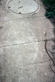
 Eltham District Historical Society Inc
Photograph, Foothpath and kerb damage, Madine Way, Eltham, 3 Sep 1981
Roll of film taken by Eltham Shire Council officers of roads and houses in the Eltham East area, 3 September 1981 prior to construction of new water main; including views of existing damage to footpaths and gutters and general views of Beard Street. These images provide a perspective of housing estate developments and changes in housing styles and road development which began sweeping in from the mid 1970s with increasing urbanisation of what was once more outlying suburbs and regions.35mm colour positive transparency (1 of 28) Mount - Kodak Kodachrome Cardeltham, infrastructure, roads, footpaths and gutters, madine way -
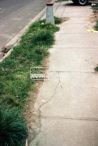
 Eltham District Historical Society Inc
Photograph, Madine Way, Eltham, 3 Sep 1981
Roll of film taken by Eltham Shire Council officers of roads and houses in the Eltham East area, 3 September 1981 prior to construction of new water main; including views of existing damage to footpaths and gutters and general views of Beard Street. These images provide a perspective of housing estate developments and changes in housing styles and road development which began sweeping in from the mid 1970s with increasing urbanisation of what was once more outlying suburbs and regions.35mm colour positive transparency (1 of 28) Mount - Kodak Kodachrome Cardeltham, infrastructure, roads, madine way, tadema park -
 Eltham District Historical Society Inc
Photograph, Beard Street, Eltham, 3 Sep 1981
Roll of film taken by Eltham Shire Council officers of roads and houses in the Eltham East area, 3 September 1981 prior to construction of new water main; including views of existing damage to footpaths and gutters and general views of Beard Street. These images provide a perspective of housing estate developments and changes in housing styles and road development which began sweeping in from the mid 1970s with increasing urbanisation of what was once more outlying suburbs and regions.35mm colour positive transparency (1 of 28) Mount - Kodak Kodachrome Cardeltham, infrastructure, roads, beard street, frank street, shalbury avenue -
 Eltham District Historical Society Inc
Photograph, Beard Street, Eltham, 3 Sep 1981
Roll of film taken by Eltham Shire Council officers of roads and houses in the Eltham East area, 3 September 1981 prior to construction of new water main; including views of existing damage to footpaths and gutters and general views of Beard Street. These images provide a perspective of housing estate developments and changes in housing styles and road development which began sweeping in from the mid 1970s with increasing urbanisation of what was once more outlying suburbs and regions.35mm colour positive transparency (1 of 28) Mount - Kodak Kodachrome Cardeltham, infrastructure, roads, beard street -
 Eltham District Historical Society Inc
Photograph, Beard Street, Eltham, 3 Sep 1981
Roll of film taken by Eltham Shire Council officers of roads and houses in the Eltham East area, 3 September 1981 prior to construction of new water main; including views of existing damage to footpaths and gutters and general views of Beard Street. These images provide a perspective of housing estate developments and changes in housing styles and road development which began sweeping in from the mid 1970s with increasing urbanisation of what was once more outlying suburbs and regions.35mm colour positive transparency (1 of 28) Mount - Kodak Kodachrome Cardeltham, infrastructure, roads, beard street, frank street -
 Eltham District Historical Society Inc
Photograph, Beard Street, Eltham, 3 Sep 1981
Roll of film taken by Eltham Shire Council officers of roads and houses in the Eltham East area, 3 September 1981 prior to construction of new water main; including views of existing damage to footpaths and gutters and general views of Beard Street. These images provide a perspective of housing estate developments and changes in housing styles and road development which began sweeping in from the mid 1970s with increasing urbanisation of what was once more outlying suburbs and regions.35mm colour positive transparency (1 of 28) Mount - Kodak Kodachrome Cardeltham, infrastructure, roads, beard street, grove street, valonia drive, wycliffe crescent, livingstone road -
 Eltham District Historical Society Inc
Photograph, Beard Street, Eltham, 3 Sep 1981
Roll of film taken by Eltham Shire Council officers of roads and houses in the Eltham East area, 3 September 1981 prior to construction of new water main; including views of existing damage to footpaths and gutters and general views of Beard Street. These images provide a perspective of housing estate developments and changes in housing styles and road development which began sweeping in from the mid 1970s with increasing urbanisation of what was once more outlying suburbs and regions.35mm colour positive transparency (1 of 28) Mount - Kodak Kodachrome Cardeltham, infrastructure, roads, beard street