Showing 10891 items
matching land
-
 Kiewa Valley Historical Society
Report - Land Conservation Council x2, Land Conservation Council, Victoria Melbourne, April 1978, October 1974
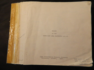
Land Conservation Act 1970 established the Land Conservation Council to investigate and recommend to the Minister use of public land in Victoria. It describes and assesses the natural resources:-Physiography, Geology, Topography, Land Systems, Outdoor Recreation, Public land and blocks. Primary Production. Vegetation.North East Victoria includes the Kiewa Valley. This report gives an understanding of the development of the area.Thick heavy book with 312 pages with black and white photos. Back half has a folder with heavy cardboard attached to thick cardboard back cover. Inside folder are 9 maps with color each with a different title.Stamped on Front Cover: "Mount Beauty High School" Has a library borrowing slip at the back of the last page.land conservation council, environment, public land, kiewa valley, planning -
 Bendigo Military Museum
Drawing - Land Headquarters Cartographic Company’s Cricket Team Sketches, Fortuna, Bendigo, c1943
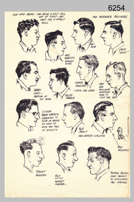
This is a page containing portrait profile sketches of 14 members of Fortuna’s cricket team, possibly taken from a booklet published at Bendigo’s Land Headquarters Cartographic Company circa 1943. Fortuna’s involvement in the Bendigo community and local sporting competitions in the 1940s is covered in page 31 of Valerie Lovejoy’s book 'Mapmakers of Fortuna – A history of the Army Survey Regiment’ ISBN: 0-646-42120-4. It is noted Fortuna’s Cricket Team competed in the summer of 1943. From the annotations of each individual’s name or nickname and other comments, the team members were probably V15403 SGT RC Papworth, 315649 HR Webster, V301426 SGT JR Neander, V510526 SPR RL Neander, VX85797 SGT WH Eddy, VX121647 SGT KH Harris, VX110276 CPL HM Jackson or VX119801 LR Jackson, VX37958 CPL DD Milligan, VX37958 SPR RJ Barber, VX85798 WO2 RR Pratt, VX85805 SGT GW Vallence, VX86152 CP LA Burford, V275492 SGT Ron Little and VF510725 SPR VM Bond or VX100878 WO2 WJ Bond. This is a page containing profile sketches of 14 members of Fortuna’s cricket team, possibly taken from a booklet published at Bendigo’s Land Headquarters Cartographic Company circa 1943. Each sketch is annotated with the individual’s name or nickname, and some have witty comments in relation to their cricketing prowess. The black and white A4 size portrait sketch was printed on a single buff manilla card and are part of the Army Survey Regiment’s Collection. The sketch was scanned at 300 dpi. Each sketch is annotated: Top Row L to R: SLAP HAPPY PAPPY - CAN DRIVE A GOLF BALL OUT OF SIGHT - BUT CAN’T SEE A CRICKET BALL, HEC. WEBSTER – HOOKEY KING, THE NEANDER BROTHERS BOB, JACK “LUCKY”. Second Row L to R: BARRY EDDY – BETTER AT THE MIKE, KEITH HARRIS, SCHNOZ JACKSON - NOSE THE GAME, CAPT. DON MILLIGAN WONDERS HOW TO STOP THE ROT. 3rd Row L to R: SCORER RALPH BARBER LEARNING TO TYPE IN ORDER TO KEEP UP WITH THE FALL OF WICKETS, BOB PRATT OUR HERBERT SUTCLIFFE, BILL VALLENCE, Bottom Row L to R: TORCHY BURFORD, RON LITTLE WICKET KEEPER, DOCTOR BOND – USED MAINLY TO INFLUENCE THE UMPIRE. royal australian survey corps, rasvy, army survey regiment, army svy regt, fortuna -
 Federation University Historical Collection
Photograph, Gippsland Institute of Advanced Education Campus Land for Wildlife, c2000
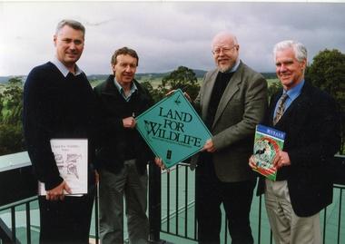
Four men stand holding a Land for Wildlife sign. Left to right: Anton Wray, DNRE Representative, B. McKenzie (PUC), Ron Dickson, Science. If you can assist with infrormation on this photograph please use the email link below. gippsland campus collection, gippsland institute of advanced education, anton wray, ron dickson, b. mckenzie -
 Orbost & District Historical Society
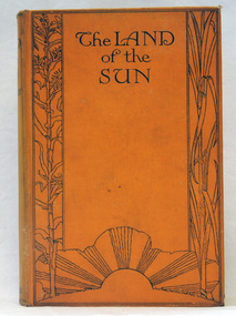
book, Butler & Tanner, The Land of the Sun, 1924
This is the author's account of life in Northern Queensland. Edwin James Brady was an Australian poet. He was born at Carcoar, New South Wales, and was educated both in the United States and Sydney. He worked as a wharf clerk, a farmer, and journalist, and edited both rural and city newspapers. Brady established a writers' and artists' colony at Mallacoota, in 1909, and he continued to live there until his death in 1952. E. J. Brady was a leading figure of Australian literature. He has an association with Mallacoota, a small town in the East Gippsland region of Victoria, Australia. A 303 pp book with a hard back cloth covered bright orange cover. It is titled in black print " The Land of the Sun" and has black print illustrations of crops and the sun. It contains black/white plates and a fold-out map of Queensland.brady-edwin-james book--the-land-of-the-sun queensland-northern -
 Ringwood and District Historical Society
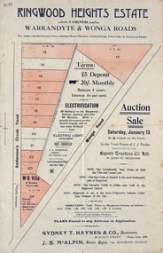
Flyer, Land Auction Sale Advertisement - Ringwood Heights Estate, Ringwood, Victoria - circa 1923
Advertisement for land and weatherboard villa auction sale on Saturday, January 13 (1923?) - Ringwood Heights Estate, corner Warrandyte and Wonga Roads, North Ringwood, with terms of sale, summary of local features and services, and map showing layout of subdivisionSubdivision includes Wonga Road and Anderson's Creek Road (later Warrandyte Road). Agents - Sydney T. Haynes & Co., Auctioneers, 60 Queen Street, Melbourne. Phone Central 3400; J.B. McAlpin, Estate Agent, Opposite Ringwood Station. Auction in the Trust Estate of J.J. Parker, instructed by the Equity Trustees Co. Ltd. 85 Queen Street, Melbourne. -
 Ringwood and District Historical Society
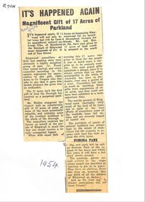
Newspaper, Newspaper articles detailing the gift of 17 acres of land south end of New Street, by Frank Pike of Heatherdale Road, for parkland
Newspaper articles detailing the gift of 17 acres of land south end of New Street, by Frank Pike of Heatherdale Road, for parkland. The new park will be called Pomona Park. It was later called Proclamation Park, used for athletics, baseball and cricket. -
 Lakes Entrance Historical Society
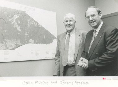
Photograph, Lakes Post Newspaper, East Gippsland Catchment and Land Protection, Lakes Entrance Victoria, 1/12/1995 12:00:00 AM
Black and white photograph of Colin Murray and Jeremy Gaylard at the East Gippsland Catchment and Land Protection meeting during inspection of the area of Lakes Entrance Victoria. Also a colour photograph of upper reaches of the Nicholson River during a dry season environment, wetlands, rivers, conservation -
 Clunes Museum
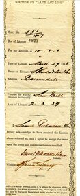
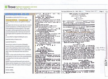
Document - LAND PURCHASE, 1862
SPECIAL LAND PURCHASE CERTIFICATE FOR LAND PURCHASED BY JAMES GRIFFIS OF CLUNES, DATED 4TH APRIL 1862.CERTIFICATE OF SPECIAL LAND PURCHASE.ENTERED ON RECORD AND ENROLLED IN THE OFFICE OF THE REGISTRAR OF THE SUPREME COURT OF THE COLONY OF VICTORIA, IN REGISTER NO. 13 SPECIAL LAND PURCHASES, FOLIO 2483 THIS THIRTEENTH DAY OF MAY 1862. SIGNED BY ACTING REGISTRARlocal history, document, certificates, griffis james -
 Orbost & District Historical Society
certificate, March 29th 1888
From the THE LAND ACT 1884.-REGULATIONS: "Any person duly licensed under section 93 of The Land Act 1884 to cut and take away any live or dead timber on Crown lands, and any person specially licensed in that behalf by the Governor in Council, may at all times enter upon the said land and therefrom cut and take away live or dead timber. "The Richardson family was one of the very early settler families to establish themselves in the Orbost district. Samuel Richardson was builder of the Paddle Steamer Curlip.A white paper licence certificate No. 182 made out to Samuel Richardson & Son for the purpose of a Saw Mill. It was to cost ten pounds per annum. Print is black and details are hand-written.richardson-samuel certificate-lands-sawmill -
Ringwood and District Historical Society
Photographs/documents, Harris Family memorabilia - photos of house and land, wedding etc. Will of Richard Francis Harris. Death Cert of James Augustine Harris. 1960s-1980s, 1960-1980s
Collection of the Harris family memorabilia given to Richard Carter by Judy O'Neill. Wedding groups may be James Harris' wedding. The collection of 22 photos include boring for water in the 1968 drought. The will of Richard Francis Harris gives a share to James Augustine Harris. James Augustine Harris' vaccination certificate was sent to Mr. M.W. Harris, Queen Street Bendigo. James lived in Dorset Rd Boronia prior to his death.Collection of 22 photos - 9x9 - black and white - house and land; 4 wedding photos - un-named; 3 miscellaneous photos; Will of Richard Francis Harris; Vaccination certificate; Death certificate of James Augustine Harris with his funeral arrangements and tributes -
 Ringwood and District Historical Society
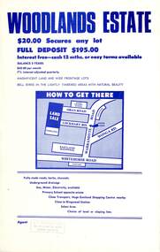
Flyer, Land Sale Advertisement - Woodlands Estate, North Ringwood, Victoria - circa 1970
Double sided single-page advertisement for land sale with locality map and layout of Woodlands Estate subdivision in North Ringwood, with summary of local features and services. No indication of date of flyer other than post-Eastland Shopping Centre opening in 1967.Subdivision includes Oban Road, Terrigal Close, Dorelaw Drive (later Melview Drive), Naroo Court, and Barook Court. Agent's rubber stamp imprint - H.C. Walton & Son, 264 Doncaster Road, North Balwyn. -
Whitehorse Historical Society Inc.
Article, Battle to ground land grabs, 2004
The Municipal Association of Victoria is fighting for exemption from laws that allow council owned land to be acquired by adverse possession.The Municipal Association of Victoria is fighting for exemption from laws that allow council owned land to be acquired by adverse possession. Like other councils Whitehorse has spent thousands fighting such claims. In 2000 the council lost a part of Forest Hill serve.The Municipal Association of Victoria is fighting for exemption from laws that allow council owned land to be acquired by adverse possession. city of whitehorse, mccallum, jessie, forest hill reserve, parks and reserves, lanes, municipal association of victoria -
Creswick Campus Historical Collection - University of Melbourne
Ephemera, Institute of Land and Food Resoures, 1997
Institute of Land and Food Resoures Letterhead paper.Letterhead -
University of Melbourne, Burnley Campus Archives
Pamphlet, The University of Melbourne, Faculty of Land and Food Resources, The University of Melbourne Burnley Campus Graduation Ceremony
Faculty of Land and Food Resources. Change in Facultygraduation, faculty of land and food resources, the university of melbourne -
 Bacchus Marsh & District Historical Society
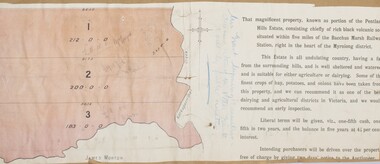
Map, Pentland Hills Estate Land Sale 1904
The Pentland Hills Estate property shown in this auction plan was put up for sale in 1904. It was a deceased estate sale. The property had been owned by Peter Grant who died in 1899. Peter Grant had worked and farmed in the Myrniong area for many years and had also been a Councillor on the Bacchus Marsh Shire for a number of terms. A property sales report in the Express newspaper recorded that the land for sale comprised 500 acres of the old Pentland Hills Estate. It was subdivided into three lots, all of which were sold at good prices. Lot l, 212 acres was sold to Messrs Thomas and Robert Lidgett of Myrniong, at £11/15/ per acre, lot 2, 200 acres, to Mr David Robertson, of Bacchus Marsh, at £9 17/0 per acre, and lot 3, 38 acres, was sold to Mr James Norton, jun at £11 per acre. A single page paper map showing a portions of land available for sale from the Pentland Hills Estate near Bacchus Marsh.The name of the seller, Mrs Grant, can seen handwritten on this map and the buyers of the three portions for sale, Lidgett lot 1, Robertson lot 2 and Morton lot 3. Parts of the text are missing along the edges due to tearing or excessive trimming of the edges. The map is pasted into a bound volume containing 76 maps or plans in total. High resolution digital image stored on BMDHS computer network. Handwritten: Mrs Grant, Myrniong, Executrix in the deceased Estate of Mr. Peter Grant to sell by public auction.land sales, pentland hills maps, myrniong area land sales, pentland hills estate -
 Whitehorse Historical Society Inc.
Document, Land Brochures, 1929
Photocopies of sale brochures of land in Mitcham by Coghill & Haughton in conjunction with Drake & Co.Photocopies of sale brochures of land in Mitcham by Coghill & Haughton in conjunction with Drake & Co. Includes (a) General advertisement for Mitcham. (b) Station Front estate and Whitehorse Hill estate. (c) Detail of Station Front Estate. (d) Detail of Whitehorse Hill estate.Photocopies of sale brochures of land in Mitcham by Coghill & Haughton in conjunction with Drake & Co.mitcham, coghill & haughton, drake & co., the esplanade, auctions, walker, edgar edwardes, donald, station front estate, whitehorse hill estate, whitehorse road, mitcham road, barkly terrace, calcutta street, delhi street, benares street, simla street, land subdivision -
 Whitehorse Historical Society Inc.
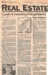
Article, Land of conservative greenies, 30/10/1993 12:00:00 AM
Newspaper article 'Land of conservative greenies' by Ben Mitchell, 30 October 1993 on development in Blackburn.Newspaper article 'Land of conservative greenies' by Ben Mitchell, 30 October 1993 on development in Blackburn. Includes quotes from Bill Gray (Nunawading Historical Society) and Kevin Rafferty (Noel Allen First National Real Estate) and brief history of Blackburn,Newspaper article 'Land of conservative greenies' by Ben Mitchell, 30 October 1993 on development in Blackburn. land use, blackburn, gray, bill, rafferty, kevin, stephens, amanda, blackburn lake sanctuary -
 Orbost & District Historical Society
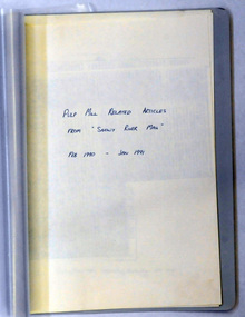
document, PULP MILL RELATED ARTICLES from "Snowy River Mail" Feb 1990 -Jan 1991, 1990 / 1991
This folder of articles was compiled by the Department of Land & Water Conservation / Forestry.This item is a useful reference tool on the pulp /paper mill proposed for East Gippsland.A small 8 pp folder of photocopied articles from the Snowy River Mail. They relate to the pulp/paper mill proposal in East Gippsland. pulp-mill-orbost -
 Mont De Lancey
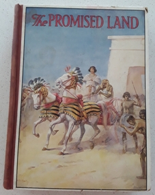
Book, Catherine Shaw et al, The Promised Land, 1928
A collection of Bible stories about The Promised Land retold by Catherine ShawHardcover children's religious instruction book, The Promised land, with picture of an Egyptian chariot race in biblical times with red lettering for title at top of illustration. Brown spine with black printed title, 6 crowns and publisher name. Black and white and coloured illustrations throughout.fictionA collection of Bible stories about The Promised Land retold by Catherine Shaw books, fiction, biblical stories, children's books -
 Ringwood and District Historical Society
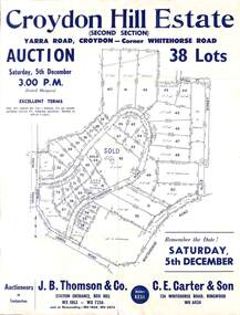
Flyer, Land Auction Sale Advertisement, Croydon Hill Estate, Croydon, Victoria - 1959
Single sided land auction sale advertisement for 38 residential allotments - Croydon Hill Estate (Second Section) Yarra Road, Croydon - corner Whitehorse Road. Auction Saturday, 5th December, and corresponding newspaper advertisement - Ringwood Mail, Thursday, November 26, 1959.Subdivision map includes Richardson Road, Yarra Road, Whitehorse Road, Alice Street, Hull Street (later Mulawa Stret). Auctioneers in Conjunction: J.B. Thomson & Co., Station Entrance, Box Hill, (Telephone) WX 1862, WX 7356, and at Nunawading, WU 1968, WU 3452, and C.E. Carter & Son, 126 Whitehorse Road, Ringwood. WU 6024. -
 Ringwood and District Historical Society
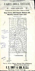
Flyer, Residential Land Sale Sub-division - Fairy Dell Estate, Warranwood, Vic. - circa 1950s
Land sale advertisement for 50 home sites with map of Sub-division showing layout of streets and allotments, summary of local features and services and terms of sale, and copy of sectional map of Crown Allotments 20 & 21B Parish of Warrandyte also showing layout of Sub-division.Subdivision includes Grandview Grove (later Bemboka Road), Merrill Crescent and Kerry Road, Warranwood. Estate Agents - V.C. Swift & Son R.E.S.I., Main Street, Croydon, Phone 20. Solicitors - Morgan, Fyffe & Mulkearns, 108 Queen Street, Melbourne. Handwritten 1970s real estate price notations for some blocks. -
Clunes Museum
Education kit - DOCUMENT, SOIL CONSERVATION AUTHORITY, MCHUGH'S GULLY - A LAND USE AND MANAGEMENT TEACHING RESOURCE KIT, 1982
ENVIRONMENTAL STUDY OF MCHUGH'S GULLY RECORDED IN THE EARLY 1980'SBUFF COLOURED LEVER ARCH FILE CONTAINING SECTIONS A TO I WITH A CARDBOARD INSERT OF FRONT COVER WITH SEPIA IMAGES OF RURAL SCENES AND TOWN SHIP PRINTED ON IT. Section A contains documents of land use and management teaching resource kit. Section I contains slides and transparenciesnon-fictionENVIRONMENTAL STUDY OF MCHUGH'S GULLY RECORDED IN THE EARLY 1980'Smchughs gully, land management, environmental impact report -
 Ballarat Tramway Museum
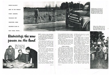
Document - Photocopies, State Electricity Commission of Victoria (SECV), "Electricity's the new power on the land", c1995
Yields information about the SEC activities in the Ballarat district during the mid 1950's and has a strong association with a number of people in the article.Photocopy of ?/1956 pages 2- 7 of SEC News featuring SEC activities in the Ballarat area, trams, personnel, black and white photographs, 3 A3 size sheets. Titled "Electricity's the new power on the land". Images added and record revised 30/10/2013trams, tramways, secv, ballarat trams, personnel, power supply -
 The 5th/6th Battalion Royal Victoria Regiment Historical Collection
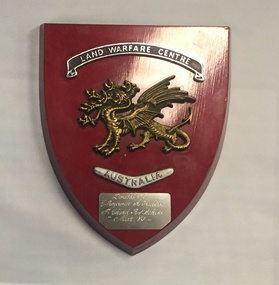
Plaque - Presentation Plaque, Land Warfare Centre Australia
Shield shaped presentation plaque varnished red with a gold seven headed dragon affixed to its centre. Above it is a black filled silver banner with "Land Warfare Centre" and below it a boomerang with "Australia" A separate silver rectangular plaque has been affixed to the bottom of the wooden plaque.Donated By E Rogerson A Trubiani P. Chard R.F. Scherr MAR '80land warfare centre -
Tatura Irrigation & Wartime Camps Museum
Booklet, River Improvement & Land Drainage, 1952
River improvement and land drainage and flood protection with spectial reference to the nature and operation of land drainage legislation in Great Britain 1952Grey cover, black writing. Includes fold out mapsirrigation, books, history, local -
 Ringwood and District Historical Society
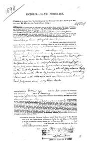
Land Purchase Document, Land Purchase for Samuel George Isaacs of Elizabeth Street, Melbourne for 148 acres, 2 roods and 9 perches in County of Mornington Parish of Ringwood - 1858, Feb-1858
1598 laminated copy on cardboard of Victoria - Land Purchase for Samuel George Isaacs of Elizabeth Street, Melbourne for 148 acres, 2 roods and 9 perches in County of Mornington Parish of Ringwood for the sum of 148 pounds 11 shillings and two pence. +Additional Keywords: Isaacs, Samuel Georgeas above -
 Kiewa Valley Historical Society
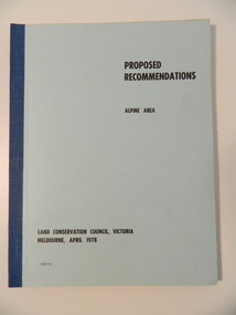
Report - Alpine Area Proposed Recommendations, Land Conservation Council, Victoria Melbourne, April 1978, April 1978
The Land Conservation Council was established by the Land Conservation Act 1970. It makes recommendations to the Minister for Conservation with respect to the use of public land. Notices showing the boundary of the study area ... published in the Victorian Government Gazette Sept. 1973. A descriptive report was published in July 1977. Submissions (1538) on the future use of public land were received & included those representing a wide cross-section of the community. These were considered in the final report.Of interest for research on the changing ideas regarding the use of public land and the environment.Blue book bound by dark blue cloth tape. It has 92 pages with maps at the end and an empty folder inside the back cover.alpine area, land conservation council, alpine study area report -
 Greensborough Historical Society
Advertisement - Digital image, Transfer of Land (William Duncan), 03/03/1877
Public advertisement on 3 March 1877 of application by William Duncan to bring a piece of land, part of Crown section 13, Parish of Nillumbik, County of Evelyn under the Transfer of Land Statute No. 9356. [This land is adjacent to St Helena Road, possibly near the Bonnie Doon Estate]Digital copy of public advertisement reproduced from TROVE 1 page.greensborough, william duncan -
University of Melbourne, Burnley Campus Archives
Administrative record - Report, The University of Melbourne, Faculty of Land and Food Resources, The Burnley Master Plan, 2007
finance, buildings -
 Flagstaff Hill Maritime Museum and Village
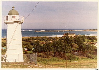
Photograph - Historical, Flagstaff Hill, John Lindsay, View of the Bay from the south boundary of the Ports and Harbours land, 1970s
The photograph shows the view of the shore and Lady Bay with the Breakwater and Middle Island all visible. It was taken to show that the Flagstaff Hill area was unlikely to have any further development between it and the Bay, with the view of development of the Flagstaff Hill Maritime Museum and Village. This photograph, a print, is one of a set of five that show the site of Flagstaff Hill. The photographer was John Lindsay, Founding Director of Flagstaff Hill Maritime Museum and Village, with the words "Photo J Lindsay" on the back. It was taken in the early 1970s during the initial stages of the development of Flagstaff Hill as a Museum and Maritime Village. The photographs belonged to the donor's grandparents, who lived in the Warrnambool district of Allansford/Naringal. The photograph is a record of the site and surrounds of Flagstaff Hill Maritime Museum and Village before its development and opening in 1975. It shows the Surfside Holiday Park, Surf Lifesaving Club, and the Breakwater. The photograph is significant for recording the location and condition of the Lower Lighthouse on the Hill.Coloured photograph, glassy print, one of a set of five. Flagstaff Hill's Lower Lighthouse is in the foreground above the Surfside Holiday Park. To the right of centre is the Surf Lifesaving Club. In the background is Lady Bay and the Breakwater and Middle Island, with the Southern Ocean the other side. The photograph's paper has the printer's watermark and a pencilled inscription on the back. The early 1970s scene was photographed by John Lindsay, Warrnambool.Label on the back: "VIEW OF THE BAY FROM the southern boundary of the Ports and Harbours land. No development below this area is likely to obstruct the view, due to the steep grade down to the Southern boundary of Flagstaff Hill property." Handwritten in pencil: "Photo J Lindsay"flagstaff hill, flagstaff hill maritime museum and village, warrnambool, maritime museum, maritime village, great ocean road, shipwreck coast, 1970s, photograph, surfside holiday park, lady bay, flagstaff hill site, john lindsay, lower lighthouse, lower light, surf lifesaving club, breakwater, middle island, ports and harbours