Showing 40723 items
matching roads and streets
-
 Canterbury History Group
Photograph - Street view of 2 new shops in Maling Road, Canterbury, Stuart Warmington, 1995
Coloured photograph of Street view of 2 new shops in Maling Road, Canterburycanterbury, maling road, shops -
 Tarnagulla History Archive
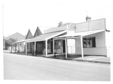
Photograph of buildings on Commercial Road, Tarnagulla, Buildings on Commercial Road, Tarnagulla, Late 1960s
Murray Comrie Collection. Burstall Hall is visible in the distant background.Monochrome photograph, streetscape. Commercial Road Tarnagulla between Poverty and Wayman Streets. tarnagulla, buildings, commercial road -
 Tarnagulla History Archive
Photograph of buildings on Commercial Road, Tarnagulla, Buildings on Commercial Road, Tarnagulla, Late 1960s
Murray Comrie Collection. A good quality original print.Monochrome photograph, streetscape. Commercial Road Tarnagulla between Poverty and King Streets. tarnagulla, buildings, commercial road -
Canterbury History Group
Photograph - Street view of the former Maling Road Theatre bronze plaque, Jan Pigot, 2004
Coloured photograph of the street view of the former Maling Road Theatre bronze plaque.canterbury, maling road, shops, signs, plaques -
Canterbury History Group
Photograph - Street view of the butchers shop at No. 82 Maling Road, Jan Pigot, 27/03/1993 12:00:00 AM
Coloured photograph of the street view of Bennet's butchers shop at No. 82 Maling Roadcanterbury, maling road, shops, bennet family -
Canterbury History Group
Photograph - Street view of the western corner of Maling Road and Theatre Place, Jan Pigot, 27/03/1993 12:00:00 AM
Coloured photograph of the street view of the western corner of Maling Road and Theatre Placecanterbury, maling road, shops, theatre place -
Canterbury History Group
Photograph - Street view of shop No. 104 Maling Road, Jan Pigot, 27/03/1993 12:00:00 AM
Coloured Photograph of the street view of the Canterbury Authorised Newsagent at No. 104 Maling Road.canterbury, maling road, shops, signs -
Canterbury History Group
Photograph - Bronze plaque in the ground at the corner of Maling Road and Bryson Street, Jan Pigot, 1994
Coloured photograph of Bronze plaque in the ground at the corner of Maling Road and Bryson Streetcanterbury, maling road, signs -
Canterbury History Group
Photograph - Shop No. 94 maling Road on the east corner of Maling Road and Bryson Street, Jan Pigot, 27/03/1993 12:00:00 AM
Coloured photograph of pharmacy shop No. 94 on the corner of Maling Road and Bryson Street.canterbury, maling road, shops, paving, trees, signs -
Canterbury History Group
Photograph - Street view of shop at No. 104 Maling Road, Jan Pigot, 1994
Coloured photograph of the street view of Canterbury Authorised Newsagent at No. 104 Maling Roadcanterbury, maling road, shops -
 Wodonga & District Historical Society Inc
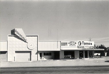
Photograph - Mann Collection Album - Dunstan's Corner, Wodonga, C. 1970s
These town photos are part of a collection donated by Elaine Mann. Elaine was married to David Mann, a successful Wodonga businessman and community leader who passed away in Wodonga in June 2012. David was a member of the Mann family who began their business in Wodonga in 1920. Elaine was a teacher in Wodonga for many years and an active member of the community. Arthur Dunstan Hardware Arthur Dunstan established mills at Red Bluff on the Mitta and a timber yard at Wodonga. He also built a sawmill at Glen Wills in 1931 which operated for about 16 years. A larger and more modern sawmill with drying kilns was erected at Eskdale in 1947. He was contracted to build Wodonga’s Municipal sale yards in 1935, followed by the Wangaratta sale yards. This created so many forward orders that he bought a large block of land on the corner of Beechworth and Tallangatta Roads and opened a timber mill and hardware store. The business stood on this corner for about 40 years. A large proportion of the company's timber output was processed at the Wodonga yards into flooring, weatherboards, mouldings etc. and practically the whole output was distributed locally and throughout the Riverina and eastern areas of New South Wales, and Canberra. At its peak Dunstan’s was one of the biggest sawmilling businesses in Victoria and in Wodonga employed 150 people and milled l6,000,000 super feet of timber annually. A super foot is a measurement for timber, equal to one foot square by one inch thick. Arthur Dunstan also built Tower Place in High Street. He died in Wodonga in 1963 and the business was continued on by his sons. Dunstan’s timber yards in Wodonga were sold to Ezerd Industries in 1987 with the retail section being bought by BBC Hardware.This photo collection is of significance as it documents how the businesses and buildings in Wodonga have evolved and contributed to community throughout the late 20th century. A. Dunstan & Sons Hardware was located at the roundabout on the corner of High Street and Thomas Mitchell Drive (Formerly Tallangatta Road). "Southside Terrace" now occupies this site.wodonga businesses, high st wodonga, dunstan's hardware wodonga -
 Whitehorse Historical Society Inc.
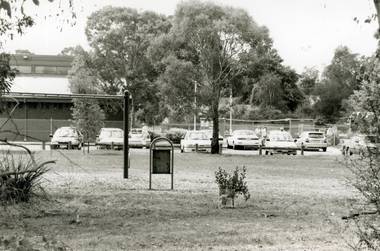
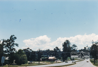
Photograph, Heatherdale Reserve, 2000
Produced as one of a series of 24 prints commissioned by Nunawading & District Historical Society -|Theme: Intersections of Mitcham and Nunawading 2000/2001.|See also Series by P. Simmenauer on the same theme.Black and white photograph - print and negative of Heatherdale Reserve - Whitehorse side of Heatherdale Road - Features view of Heatherdale Bowls Club with flower garden. Located between Purches Street and Heatherdale Road to south of Panel street.heatherdale bowls club, heatherdale road vermont, heatherdale reserve -
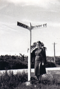 Whitehorse Historical Society Inc.
Photograph, Road signs - No roads
... Road signs - No roads ...Sent to a parishioner at Christ Church Mitcham, by Phyllis Grant who lived at the Migrant Hostel in Mitcham in 1952-54, where her husband did development work under the P.M.G.Black and white photograph of road signs in Rooks Road. Note spelling of Rookes which is incorrect and Henry Street which no longer exists. It is presumed that it pointed to a street which lost its identity with the development of the Migrant Hostelrooks road mitcham -
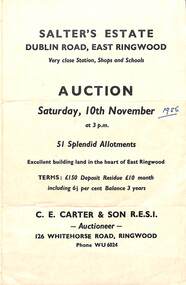 Ringwood and District Historical Society
Flyer, Land Sale Auction Brochure, Salter's Estate, East Ringwood, Vic. - 1956
Folded single page advertising auction of allotments on Saturday, 10th November (1956), including layout of subdivision and terms of sale.Subdivision includes Railway Avenue, Nicholson Street, Althol Grove (later Morcom Avenue), Illoura Avenue, Tweed Street, Merry Street, and Dublin Road. (Agent) C.E. Carter & Son R.E.S.I., Auctioneer, 126 Whitehorse Road, Ringwood, Phone WU6024. -
 Wodonga & District Historical Society Inc
Photograph - Falkiner Electric Road Train in front of George Leighton's Wodonga Store and Bakery Wodonga 1914
This image of the Ralph Falkiner’s Mueller Petrol-Electric Road Train was taken in Wodonga in February 1914. Imported from Germany by Mr Ralph S Falkiner in late 1913, the train’s inventor, Major W A Mueller with two assistants, came to Melbourne to assemble then commission the train. The train cost Mr Falkiner about £13,000 plus £4,591 import duties. The Falkiner family were sheep breeders in the Western Riverina and he hoped to use the road train primarily to convey wool to the railways for despatch to Sydney. The train was 216 feet long, weighed 43.5 tons with a top speed loaded of 6-8m/h and petrol consumption up to two gallons per mile. Its first Australian journey was to haul 50 tons of cargo to Edmondson & Co at Wagga Wagga, 277 miles away. The journey from Melbourne was plagued with problems including broken cylinders and crank shaft and overheating as it was not designed for Australian climatic conditions. Three months after leaving Melbourne it arrived in Wodonga. A series of problems between Springhurst and Wodonga, including broken cylinders and valves caused an eight day delay. Some of the cargo was off-loaded in Albury, then after repairs the train continued on to Wagga where it arrived in May 1914. After unloading there, the road train was taken to Mr Falkiner's Groongal Station, near Hay and subsequently made several long trips into drought-stricken areas or the Western Riverina. Eventually the dream collapsed when the engines gave out after the train bogged in the sticky black soil of the Hay plain with 251 bales of wool on board. The train was finally railed back to Melbourne and stored but destroyed when the warehouse burnt down. In this photo, the road train is drawn up outside the Wodonga Stores and Bakery owned and operated by George Leighton. Mr Leighton began his business opposite the Terminus Hotel in Sydney Street, Wodonga in 1885. His business included a general store, stocking groceries, ironmongery, drapery, crockeryware, boots and shoes as well as a bakery. He was very actively involved in the community and served on the Wodonga Council for 18 years including three terms as Wodonga Shire President in 1901 – 02, 1910-11 and 1913-14. He was also Chairman of the Wodonga Waterworks Trust for several terms. Mr. Leighton also took a prominent part in the movement to establish a Public Library in Wodonga. His other involvements including being a Founder of the Wodonga Lodge of Freemasons, Honorary Treasurer of the Wodonga Bulldogs Football Club and Secretary of the Wodonga Racing Club. Mr Leighton passed away in Wodonga in 1916.This image is significant because it records a rare event in Wodonga and an experiment in Australian road transport.Black and white images of the Falkiner Road Train in Wodonga and on its first journey from Melbourne to Wagga, NSW It is taken in front of the Wodonga Stores and Bakery operated by George Leighton in Sydney Street, Wodonga.falkiner electric train, early road transport, high street wodonga, george leighton -
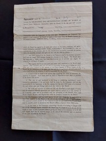 Mont De Lancey
Document - Land Agreement, Melbourne and Metropolitan Board of Works, 02/07/1951
A double sided official original page Agreement between the Melbourne and Metropolitan Board of Works at Spencer Street Melbourne and Maxwell Hay Proctor for the supply of water to the Queens Road Wandin property on the Second day of July 1951.A double sided official original page Agreement between the Melbourne and Metropolitan Board of Works at Spencer Street Melbourne and Maxwell Hay Proctor for the supply of water to the Queens Road Wandin property on the Second day of July 1951. It has The Common Seal of the Melbourne and Metropolitan Board of Works affixed in the presence of the Chairman, Member and Acting Secretary. It is signed Sealed and Delivered by the said Maxwell Hay Proctor in the presence of the witnesses D. Campbell and J.D.It has 'The Common Seal of the Melbourne and Metropolitan Board of Works affixed in the presence of the Chairman, Member and Acting Secretary. It is hand signed Sealed and Delivered by the said Maxwell Hay Proctor in the presence of the witnesses D. Campbell and J.D.'administrative records, documents, land agreements, melbourne metropolitan board of works -
 Marysville & District Historical Society
Photograph (Item) - Colour photograph, Travel Victoria, 2006
A colour photograph of Murchison Street in Marysville in Victoria.A colour photograph of Murchison Street in Marysville in Victoria. The photograph shows the corner of Murchison Street and Pack Road in Marysville.murchison street, marysville, victoria, photograph -
 Eltham District Historical Society Inc
Photograph, M. North, Main Road, Eltham near Fitzsimons Lane Roundabout, Dec 1985, 1/12/85
Two colour photographs of Main Road, ElthamSouth between Falkiner Street and Bolton Street at the roundabout of Fitzsimons Lane, Eltham, Dec 1985Noted on 463B 'See 1934 small black and white snap of flooded bridge and the same two shops. This snap taken from same location, Dec 1985. Old Eltham Park on right of photo The two shops at left (Ansel and Muir) Road ahead crosses new bridge over the Diamond Creek, Eltham Main Road now dual highway, through Lower Plenty to this bridge'main road, eltham, eltham south, fitzsimons lane, round about, falkiner street -
Port Melbourne Historical & Preservation Society
Plan - Tramway, Normanby Road, Ingles Street to Boundary Street, Port Melbourne, 14 Mar 1893
Plan of tramway in Normanby Road from Ingles Street to Boundary Street, together with written specification for works attached (Reg 66.2), 1893.A.V. Heath (Town Surveyor) J.J. Bartlett (Mayor)engineering - roads streets lanes and footpaths, transport - tramways, town planning, town clerks, mayors, arthur victor heath, james john bartlett -
 Whitehorse Historical Society Inc.
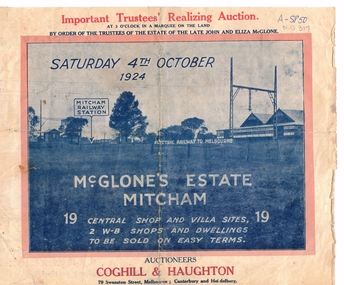
Document, McGlone Estate Mitcham
Pamphlet on auction of McGlone's Estate,Pamphlet on auction of McGlone's Estate, Mitcham 1924. Bordered by McGlone Street, Whitehorse Road, Station Street and Mitcham Railway line and stationPamphlet on auction of McGlone's Estate, land sales, auctions, mcglone estate, mcglone, john, elizabeth, station street, mitcham, whitehorse road, mitcham railway station, coghill & haughton -
 Charlton Golden Grains Museum Inc
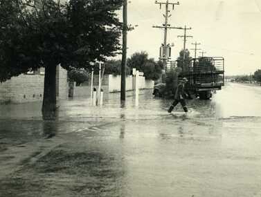
Photograph, Cameron, Ian, 1972 Flash Flood, Jan 1972
1972 Flash flood, cnr of High St and Armstrong St, Charlton.B/W photograph of 1972 flash flood Corner High Street & Armstrong Streets. Man crossing road through flood water.flood, charlton, armstrong street -
 Kew Historical Society Inc
Plan - Subdivision Plan, Jas R Mathers Son & McMillan, East Kew Tramway Estate, 1915
Pru Sanderson, in her groundbreaking ‘City of Kew Urban Conservation Study : Volume 2 - Development History’ (1988), summarised the periods of urban development and subdivisions of land in Kew. The periods that she identified included 1845-1880, 1880-1893, 1893-1921, 1921-1933, 1933-1943, and Post-War Development. These periods were selected as they represented periods of rapid growth or decline in urban development. An obvious starting point for Sanderson’s groupings involved population growth and the associated economic cycles. These cycles also highlighted urban expansion onto land that was predominantly rural, although in other cases it represented the decline and breakup of large estates. A number of the plans in the Kew Historical Society’s collection can also be found in other collections, such as those of the State Library of Victoria and the Boroondara Library Service. A number are however unique to the collection.The Kew Historical Society collection includes almost 100 subdivision plans pertaining to suburbs of the City of Melbourne. Most of these are of Kew, Kew East or Studley Park, although a smaller number are plans of Camberwell, Deepdene, Balwyn and Hawthorn. It is believed that the majority of the plans were gifted to the Society by persons connected with the real estate firm - J. R. Mathers and McMillan, 136 Cotham Road, Kew. The Plans in the collection are rarely in pristine form, being working plans on which the agent would write notes and record lots sold and the prices of these. The subdivision plans are historically significant examples of the growth of urban Melbourne from the beginning of the 20th Century up until the 1980s. A number of the plans are double-sided and often include a photograph on the reverse. A number of the latter are by noted photographers such as J.E. Barnes.The East Kew Tramway Estate was a subdivision of two separate parcels of land between Adeney Avenue and Normanby Road. The larger section included 54 lots facing Adeney Avenue, Argyle Road, and Campbell, Hunter and Wishart Streets. [Hunter and Wishart Streets were created as part of the subdivision.] A further 17 allotments faced Normanby Road, Hubert and Campbell Streets. [The name of Hubert Street was later to be changed to Cecil Street.] The promotion of the sale referred to the advantages of living between two tram routes, in High Street and Cotham Road. On the plan, quaintly drawn trams mark these routes. Also on the plan is the route of part of the Outer Circle [Railway] Line.east kew tramway estate, subdivision plans - east kew -
 Whitehorse Historical Society Inc.
Photograph, Northcote Street, Mitcham, 8/09/1958 12:00:00 AM
Black and white photo of Northcote Street, Mitcham.- Eastern end of what is now Brunswick Road- Road (track ) conditions indicative of that part of the city.o'rourke, l. -
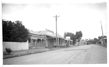
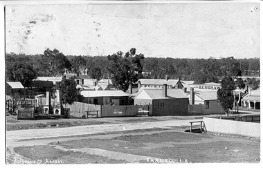 Tarnagulla History Archive
Photograph of Tarnagulla from Poverty Street, behind Bank, Tarnagulla from Poverty Street, behind Bank, Between 1886 and 1899
Murray Comrie Collection. Information collated by Murray Comrie: Photo after 1886 and before 1899. Shows bakers shop at corner of Commercial Rd and Poverty St, bakery stables and horse. Clouston's, Renshaw's Victoria House, Golden Age Hotel, Renshaw's Commerce House and Post Office. This is an original photographic postcard. Monochrome photographic postcard. View of part of Commercial Road and Poverty Streets, Tarnagulla, from a position on Poverty Street behind the Bank site. Premises on Commercial Road which are visible include the Golden Age Hotel and Renshaw's Drapers.Text near bottom edge: 'Johnsn & Co. Ararat' and 'Tarnagulla'.tarnagulla, commerce, shops, businesses, streetscapes, horses, stables, poverty street, commercial road, main street, golden age hotel, renshaw's, bakery, clouston's -
Whitehorse Historical Society Inc.
Map, City of Whitehorse, 1/03/1995 12:00:00 AM
Map showing streets of the City of Whitehorse from Mullum Mullum Creek to the north to Highbury Road and Warrigal Road in the west, to Heatherdale Road in the east.Map showing streets of the City of Whitehorse from Mullum Mullum Creek to the north to Highbury Road and Warrigal Road in the west, to Heatherdale Road in the east. Prep. by Richard Meloni. Scale 1:15,000Map showing streets of the City of Whitehorse from Mullum Mullum Creek to the north to Highbury Road and Warrigal Road in the west, to Heatherdale Road in the east. city of whitehorse, mullum mullum creek -
 Whitehorse Historical Society Inc.
Photograph, Narmara Primary School, 13/01/1994 12:00:00 AM
Coloured photo of Narmara Primary School, Namara Street, looking North. School on North side of Highbury Road, between Middleborough Road and Blackburn Road. Since demolished and site developed for housing.narmara primary school, warner, philip -
 Eltham District Historical Society Inc
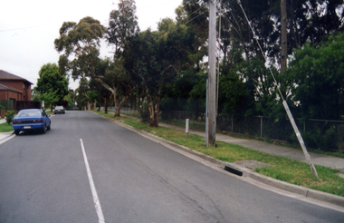
Slide - Photograph, Unidentified location, Eltham district, c.1992
... streets ...35mm colour positive transparency Mount - Black and Whiteunidentified, infrastructure, speedhumps, streets, roads -
 Eltham District Historical Society Inc
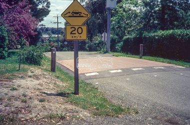
Slide - Photograph, Unidentified location, Eltham district, c.1992
... streets ...35mm colour positive transparency Mount - Black and Whiteunidentified, infrastructure, speedhumps, streets, roads -
 Eltham District Historical Society Inc
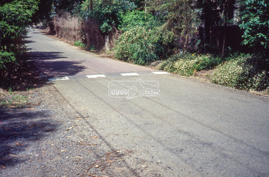
Slide - Photograph, Unidentified location, Eltham district, 1993
... streets ...35mm colour positive transparency Mount - Black and Whiteunidentified, infrastructure, streets, roads, footpaths and gutters -
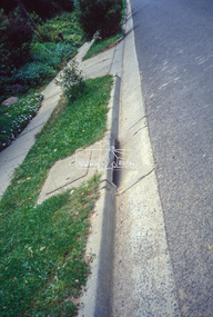
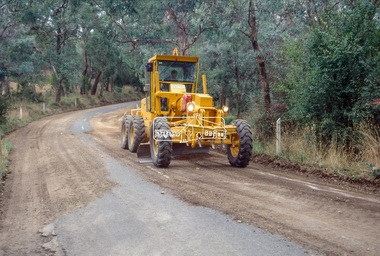 Eltham District Historical Society Inc
Slide - Photograph, Unidentified location, Eltham district, 1993
... streets ...35mm colour positive transparency Mount - Black and Whiteunidentified, infrastructure, streets, roads, graders