Showing 10601 items
matching sites
-
 City of Moorabbin Historical Society (Operating the Box Cottage Museum)
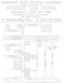
Flyer - McKinnon Road Estate, McKinnon, 1924
The train line from the city to Frankston was electrified in 1922 which intensified the sale in the municipality of Moorabbin, particularly land which was in the vicinity of the railway stations.Example of the progress of the Municipality of MoorabbinAdvertising flyer for auction of real estate sales - plan of building blocks for saleMcKinnon Road Estate, McKinnon Auction 26 April 1924 - 17 shop sites & 21 villa sitesgraham ave, prince edward ave, station street, mckinnon road, mckinnon, real estate, auctions -
 Stawell Historical Society Inc
Photograph, Don Rickard, Black Range Quarry Site, 1999
Black Range Quarry SiteOn Reverse Bullocky Mary's House (Mary Honan) 1. Black Range. Campbell's Property Lot 14. Bullocky Mary Rd. quarry site Granite. Nr Cox's Fence. Don Rickard May 1999stawell -
 Port Melbourne Historical & Preservation Society
Photograph - J Kitchen & Sons perimeter survey, north corner Ingles and Woodruff Streets, Dec 2013
As the former j Kitchen & Sons site was being cleared, Lionel Layfield, who had worked at the site for many years undertook several pictorial perimeter surveys. These photos were taken in Dec 2013.Series 1 of colour photographs taken by Lionel Layfield as he walked around the perimeter of the J Kitchen & Sons Pty Ltd factory site during the early demolition of most of the buildings. .46-.54- warehouse on North corner of Ingles and Woodruff streetsindustry - manufacturing, built environment - industrial, business and traders - soaps/candles, j kitchen & sons pty ltd, symex holdings ltd, north port oval, port melbourne cricket and football oval -
 Whitehorse Historical Society Inc.
Pamphlet, Hill 60 Estate, 1/02/1929 12:00:00 AM
Auctioneers brochure for Hill 60 estate,Auctioneers brochure for Hill 60 estate, Tunstall, 37 sites, subdivisional auction sale, 3.30 pm Saturday 23 February 1929. Agent: Frank Fisher & CoAuctioneers brochure for Hill 60 estate, hill 60 estate, tunstall, frank fisher & co, forest hill, menin road, nunawading, mount pleasant road, nunawading, shady grove, nunawading, fisher, frank -
 Lakes Entrance Regional Historical Society (operating as Lakes Entrance History Centre & Museum)
Photograph, Fish Marie, 1995
Also another black and white photograph of cleared site of Pecks factory 01611.1Black and white photograph of Bullock Island. It shows the site of Pecks fishing processing factory being cleared, Kalimna Heights in background taken from New Works area of southern shore of Cunninghame Arm. Lakes Entrance Victoriaislands, dredging, transport, machinery -
University of Melbourne, Burnley Campus Archives
Plan, Base Plan Front Garden Maughan Parade, c. 1980
1. Tracing paper and paper copies, Site Plan. Scale 1:100. Drawn by JK. 2. Site plan Scale 1:200 (plan of whole site)maughan parade, gardens -
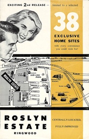 Ringwood and District Historical Society
Flyer, Land Sale Brochure - Roslyn Estate, Ringwood, Vic. - circa 1960s
Land sale advertisement for 2nd release of residential sites with area map, layout of the estate, terms of sale, and summary of local facilities and services.Subdivision includes Daisy Street, Vale Street, Joan Court, Christine Court, and Westmore Drive. (Agent) Heathmont Estate Agency, 103 Canterbury Road, Heathmont. (Phone) WU7808-9. Brochure also includes map with streets marked as "Sold" - Reilly Street, Adrian Court, Daisy Street, Jarma Road, Joel Court, and Ross Court, with comment that "all home sites in the first release have already been sold, and most built on." -
 Port Melbourne Historical & Preservation Society
Photograph - J Kitchen & Sons perimeter survey, Williamstown Road and Normanby Road, Dec 2013
As the former j Kitchen & Sons site was being cleared, Lionel Layfield, who had worked at the site for many years undertook several pictorial perimeter surveys. These photos were taken in Dec 2013.Series 1 of colour photographs taken by Lionel Layfield as he walked around the perimeter of the J Kitchen & Sons Pty Ltd factory site during the early demolition of most of the buildings. .01-.08 - corner of Williamstown Road and Normanby Road to Ingles Streetindustry - manufacturing, built environment - industrial, business and traders - soaps/candles, demolitions, j kitchen & sons pty ltd, symex holdings ltd, north port oval, port melbourne cricket and football oval -
Whitehorse Historical Society Inc.
Document - Drawing, Schwerkolt Cottage site management review, 1/01/1994
Site development opportunities for Schwerkolt Cottage. Drawing prepared for Site Management Review for City of Nunawading.schwerkolt cottage -
 Bendigo Historical Society Inc.
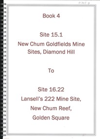
Book - NEW CHUM GOLDFIELDS MINE SITE DIAMOND HILL TO LANSELL'S 222 MINE SITE NEW CHUM REEF GOLDEN SQUARE, 1992
Book 4, Site 15.1 New Chum Goldfields Mine site Diamond Hill to site 16.22, Lansell's 222 Mine site, New Chum Reef, Golden Square. Significance reports prepared for North Central Goldfields Project: Bendigo Goldfield.David Bannearbendigo, mining, goldfields report, bendigo, gold, goldfields, history -
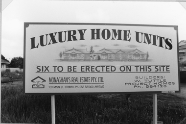 Stawell Historical Society Inc
Photograph, St. Matthew’s Sunday School -- former site c1990
Site of former Sunday school c 1990.Adverting sign from Monaghan's Real Estate with image of the houses.LUXURY HOME UNITS Six to be erected on this site. Monaghen's Real Estate Pty Ltd. 189 Main St. Stawell Ph. 053 581300 anytime. Builders W. Tuttle Project Homes Ph. 584123stawell religion -
 Port Melbourne Historical & Preservation Society
Photograph - J Kitchen & Sons perimeter survey, Ingles Street, Dec 2013
As the former j Kitchen & Sons site was being cleared, Lionel Layfield, who had worked at the site for many years undertook several pictorial perimeter surveys. These photos were taken in Dec 2013.Series 1 of colour photographs taken by Lionel Layfield as he walked around the perimeter of the J Kitchen & Sons Pty Ltd factory site during the early demolition of most of the buildings. .16-.30- from Munro St along Ingles Street to Woodruff Streetindustry - manufacturing, built environment - industrial, business and traders - soaps/candles, demolitions, j kitchen & sons pty ltd, symex holdings ltd, north port oval, port melbourne cricket and football oval -
 Port Melbourne Historical & Preservation Society
Photograph - J Kitchen & Sons perimeter survey, Boundary Street, Dec 2013
As the former j Kitchen & Sons site was being cleared, Lionel Layfield, who had worked at the site for many years undertook several pictorial perimeter surveys. These photos were taken in Dec 2013.Series 1 of colour photographs taken by Lionel Layfield as he walked around the perimeter of the J Kitchen & Sons Pty Ltd factory site during the early demolition of most of the buildings. .37-.45 - along Boundary Street past White Street to Normanby Roadindustry - manufacturing, built environment - industrial, business and traders - soaps/candles, j kitchen & sons pty ltd, symex holdings ltd, north port oval, port melbourne cricket and football oval -
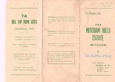 Whitehorse Historical Society Inc.
Document, Mitcham Hills Estate, n.d
Sale brochure for 'Mitcham Hills Estate',Sale brochure for 'Mitcham Hills Estate', 74 sites bordered by McKeon and Quarry Roads, to the order of Commander H.E. Turner and Mrs Turner. Agent: Drake & Co.. With 'List of Sale Prices'.Sale brochure for 'Mitcham Hills Estate',land subdivision, mitcham hills estate, mckeon road, mitcham, quarry road, endeavour street, moresby street, beaufort street, turner, harold exton, cmdr., (mrs), drake & co. -
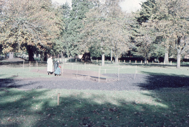 Friends of Ballarat Botanical Gardens History Group
Slide - Colour transparency, 1960
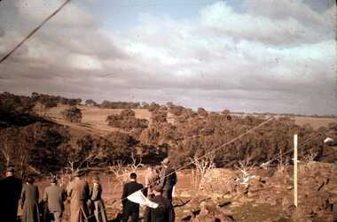
The Rotary Club volunteered to build the paddling pool for children in August 1960.Added social amenity to cater for children after WW2.Site for the paddling poolballarat botanical gardens, trees, parks, lawns, men, frank browm, bill roff, rotary club, paddling pool, volunteers, 1960, swimming -
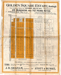 City of Moorabbin Historical Society (Operating the Box Cottage Museum)
Flyer - Golden Square Estate, Bentleigh, 1923
Land sales in the Municipality of Moorabbin increased when the train line from the City to Frankston was electrified.Example of the progress of the Municipality of MoorabbinThe train line from the city to Frankston was electrified which intensified the sale in the municipality of Moorabbin, particularly land which was in the vicinity of the railway stations.Golden Square Estate, Bentleigh - J. D. Graham, Stott & Burke - 25 business sites and 112 home sitescentre road, brewers road, jasper road, robert street, mitchell street, daley street, bendigo avenue, auction, real estate, moorabbin, bentleigh -
 Ballarat Heritage Services
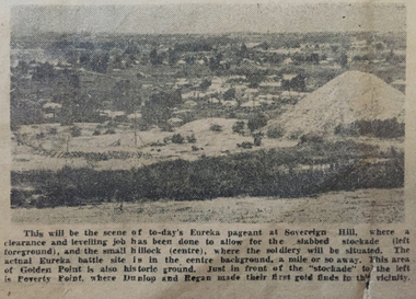
Image, Site of the Eureka Pageant, 1954, 1954
The Eureka Pageant was held on Saturday 04 December 1954.A black and white image of Ballarat's Sovereign Hill in 1854. Sovereign Hill was the site of the Eureka Pageant held as part of the Eureka Stockade centenary celebrations.Original caption: This will be the scene of to-day's Eureka pageant at Sovereign Hill, where a clearance and levelling job has been done to allow for the slabbed stokade (left foreground), and the small hillock (centre), where the soldiery will be situated. The actual Eureka battle site is in the centre background, a mile or so away. This area of Golden Point is also historic ground. Just in front of the "Stockade" to the left is Poverty Point, where Dunlop and Egan made their first gold finds in this vicinity.eureka stockade, eureka stockade centenary, sovereign hill, poverty point, eureka pageant -
 Ballarat Heritage Services
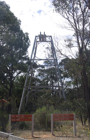
Photograph - Colour, Red, White and Blue Mine near Maldon, 2017, 17/10/2017
The Red, White and Blue mine is a site of historical, areaological and scientific importance to Victoria, and is listed on the Victorian Heritage Register of significant heritage places. It was also known as the Golden Age Mine and as Malney's Red, White and Blue Mine. Colour photograph of the Red, White and Blue historic mine site in the Muckleford State Forest, showing an intact poppet head with tubular steel legs, winding wheels and remains of timberwork.red, white and blue mine, maldon, golden age mine, maloney's red, white and blue, muckleford state forest -
Whitehorse Historical Society Inc.
Document, Memorials, 1871 & 1970
Memorial of transfer of land from William Kennard, William Coe & Francis Turner to the Board of Education, 1871 and from L.H.S Thompson, Minister for Education and Board of Education to City of Nunawading 2 June 1970.Memorial of transfer of land from William Kennard, William Coe & Francis Turner to the Board of Education, 1871 and from L.H.S Thompson, Minister for Education and Board of Education to City of Nunawading 2 June 1970. This land became the site of Vermont State School No. 1022.Memorial of transfer of land from William Kennard, William Coe & Francis Turner to the Board of Education, 1871 and from L.H.S Thompson, Minister for Education and Board of Education to City of Nunawading 2 June 1970.victoria, board of education, vermont state school, no, 1022, kennard, william, coe, william, turner, francis, city of nunawading -
Glenelg Shire Council Cultural Collection
Slide - Slide - Cashmore Airport, Portland, 1980s
Coloured slide. Runway construction site. Earthmoving equipment back right, site buildings back left.portland airport, cashmore airport, construction site, runway, engineering -
 Bendigo Historical Society Inc.
Slide - DAVID MCDONALD COLLECTION: EPPALOCK. CONSTRUCTION, c1960
Eppalock. Construction. Adults looking over the site of Lake Eppalock. Markings: Eppalock Dam Site 1960kodakcivil engineering, water supply, eppalock -
 Bendigo Historical Society Inc.
Photograph - CASTLEMAINE GAS COMPANY COLLECTION: BUILDING SITE
Building Site Date and Location Unknown - building with Coca Cola Sign in the Background, Man walking on siteFujicolorbuildings, commercial, gas and fuel -
 The Beechworth Burke Museum
Photograph, 1907-8
The photo from 1907-8 is a sepia print, depicting a small valley with building at base. There are flumes visible above areas of water, trees on hills and a few small cottages on the hillside. Cock's Pioneer Gold & Tin Sluicing Co NZ No 2 Site. The photo was taken of Matthews Gully looking west. Sluicing was undertaken in the area from 1900 to 1942 with some short breaks between these periods. The image depicts a location mined by Cocks Pioneer Gold and Tin Sluicing Company (as recorded on the annotation on the card mount) The Cocks Pioneer Gold and Tin Mines N.L was one of El Dorado's two largest open cut sluicing mines of the 20th Century. The other was named the Cocks El Dorado Gold Dredging Company. The Cocks Pioneer Mines operated from 1901 until 1941 and found a total of 117,378 ounces of Gold and 1,673 tones of tin concentrates over these years. The Cocks company was formed in 1898 and operated until 1941. Open cut sluicing involved the use of high-powered hoses which used the centrifugal sand pump system (known as hydraulic sluicing) which broke down the soil which was then processed for gold and other precious metals. From 1914 , four years after this image was captured, the company reformed to Cocks Pioneer Gold and Tin Mines NL (previously it was known as Cocks Pioneer Sluicing Co) and undertook large scale sluicing operations until 1929 and then 1934-1941. El Dorado is located on Reedy Creek and is surrounded by forested country to the north and east. It is 20 km east of Wangaratta in Victoria's regional north-east. John Cock was the son of a Cornish minor who arrived in El Dorado in 1858. Cock founded his gold and tin mining company which ran successfully for many years in the El Dorado region. It was an open cut sluicing company because of the abandonment of underground mining after this was deemed too dangerous. In 1935 Cock's El Dorado Company commissioned the floating dredge which is still visible in El Dorado today. The dredge was built by the Thompson engineering works, Castlemaine, and weighed over 2,000 tones and today has a place on the Victorian Registers of historic buildings. Interestingly, the name El Dorado does not derive from the gold in the region, but from the Barambogie pastoral run completed by William Baker in 1840-1841. Gold was discovered in El Dorado 1854 but the gold was too deep for individual prospectors to find, it required the use of heavy machinery.The search for gold is ingrained into the history of Victoria and therefore, images like this one which portray an open cut sluicing site can reveal important information for society and technology for the date when the photograph was taken. This image is of important historical significance for its ability to convey information about sluicing and the methods used to find gold in 1910. It also shows a location where sluicing was undertook which provides insight into the impact of sluicing on the environment at a time when it was done. This image is important for current research into the history of El Dorado, a small regional location near Wangaratta in Victoria's North East. Therefore, this image has the capacity to be beneficial for research into society and the motivations of those living and working in this region during this period and therefore, has social significance. The Beechworth Burke Museum has additional images relating to gold sluicing and El Dorado which can be analysed and studied alongside images like this one.Sepia coloured rectangle photograph printed on gloss photographic paper Reverse: 1997. 2613/ A02613/ No2 site/ Matthews Gully/ Cocks Pioneer G&T. ?? Co NZ/ No2 Site looking West/ 1907-8/ (7)sluicing, hydraulic sluicing, 1907, 1908, mining, cock's pioneer gold & tin sluicing co nz, nz, site no 2, matthews gully, west, valley, building, cottages, hillside, trees, water, gold and tin mine -
Port Melbourne Historical & Preservation Society
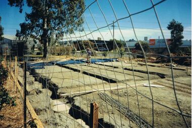
Plan - Multi-unit development, 164 Ingles Street, Port Melbourne, Site Plan 164 Ingles Street, 2015
Site plan for multi unit development. 164 Ingles St, Port Melbourne 2015-2016 A3 sheet black and white printing On the site of Symex, J KItchen &Sons factory sitebuilt environment - domestic, woodruff street development pty ltd, canny building pty ltd, j kitchen & sons pty ltd, symex holdings ltd -
Bialik College
Booklet (item) - Inspector's Report Book, 1965, 1965
... sites ...Inspector's Report Book, 1965. Please contact [email protected] to request access to this record.1960s, sites, students, teachers, shakespeare grove -
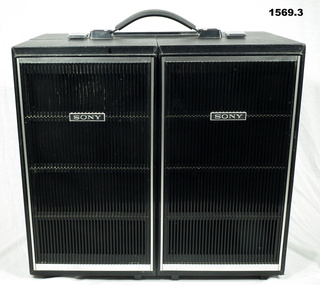 Bendigo Military Museum
Memorabilia - TAPE RECORDER, 1960’s
The item was purchased at a PX store in South vietnam during the warSony Tape Recorder .1) Reel to reel tape recorder with two dismountable speakers attached with clips and open hinges in nickle plated metal. Two reels and tape on tape deck. Exterior of case covered in black leatherette. .2) .3) Speaker dismountable - exterior of speakers covered in black leatherette, with silver coloured plastic trim.Various sites on unit - "Sony Stereo Tapecorder"personal effects, communications, radio, tap recorder -
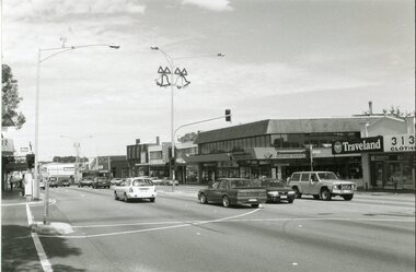 Ringwood and District Historical Society
Photograph, Ringwood black and white photographs - Maroondah Hwy. Old Town Hall site
Black and white photographMaroondah Hwy. Old Town Hall site -
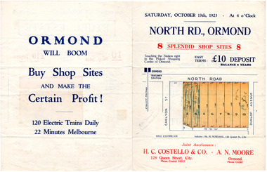 City of Moorabbin Historical Society (Operating the Box Cottage Museum)
Flyer - North Road, Ormond - H. C. Costello & Co A. N. Moore, 1923
The train line from the city to Frankston was electrified which intensified the sale in the municipality of Moorabbin, particularly land which was in the vicinity of the railway stations.Example of the progress of the Municipality of MoorabbinAdvertising flyer for auction of real estate sales - plan of building blocks for shops for saleNorth Road, Ormond - 8 shop sitesnorth road, ormond, real estate, auctions -
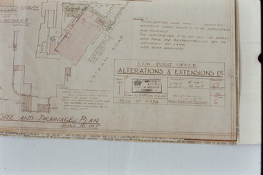 Kew Historical Society Inc
Slide - Architectural Drawing, Kew Public Offices, 1887
A civic campaign for new public offices developed in Kew in the 1880s. After much deliberation, the location chosen was the junction of Bulleen and Cotham Roads. The buildings were designed by George Watson and John Henry Harvey, architects within the Department of Public Works (Victoria). Building was commenced in 1887, and after one year, the buildings were opened. The Post Office was transferred to the new Commonwealth Government in 1901. The Police Station and Court House, sold by the Victorian Government to the City of Boroondara in 2007, are now a community cultural centre and performing arts venue.The buildings were listed on the Victorian Heritage Register Register (HO885) in 1991. They are historically and architecturally significant to the State Of Victoria because Watson and Harvey's designs exhibit diversity in integrating civil offices, they accommodate the apex of road junctions, and they demonstrate a departure from the contemporaneously favoured High Victorian Classical to the Queen Anne style in the design of civic buildings. 35mm colour transparency of an original plan by George Watson and John Henry Harvey, architects of the Department of Public Works (Victoria), in 1887 for New Public Offices at Kew. This plan was copied by the donor from an original held at the Commonwealth Archives in Brighton (Vic). The copy was made to illustrate a report that the donor made on ‘The functional planning design, building materials and construction methods of the Kew Post Office’ as part of course work at RMIT.SITE AND DRAINAGE PLAN / SCALE 16' TO 1"kew court house, kew police station, kew post office, architectural drawings, khs - slides, new public offices -- kew (vic.), architecture — queen anne style -
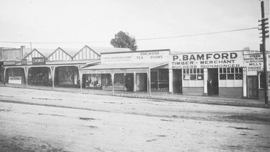 Ringwood and District Historical Society
Photograph, Maroondah Highway Central, Ringwood. P. Bamford store, corner Warrandyte Road. c1924
Black and white photograph (2 copies)Nil Site later to become Safeway store.