Showing 9458 items
matching the entrance
-
 Lakes Entrance Regional Historical Society (operating as Lakes Entrance History Centre & Museum)
Postcard, H D Bulmer, 1950 c
Also a cut down colour photograph of second humpy bridge to Bullock Island donated by M Fish number 04208.1 size 3 x 13 cm|Also two black and white photographs numbers 04208.2 and 04208.3 in SparesColour tinted postcard of Bullock Island and first traffic bridge. Island has no development.North Arm bridge and Princes Highway in foreground, New Works area across Cunninghame Arm in distance Lakes Entrance VictoriaBullock Island and Bridge Lakes Entranceroads and streets, waterways -
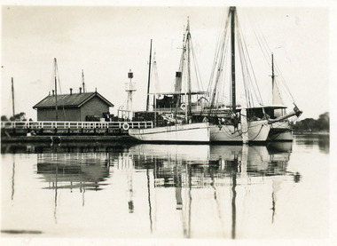 Lakes Entrance Regional Historical Society (operating as Lakes Entrance History Centre & Museum)
Postcard - Western Wharf, 1930c
Also black and white enlargement 18x25cmBlack and white small format postcard of the Western wharf. Shown on the wharf a shed and signal light. Four boats moored including either Omeo or Dargo. Reflections on calm waters of lake. Lakes Entrance VictoriaOn back 'Western Wharf Lakes Entrance'jetties, waterfront, ships and shipping -
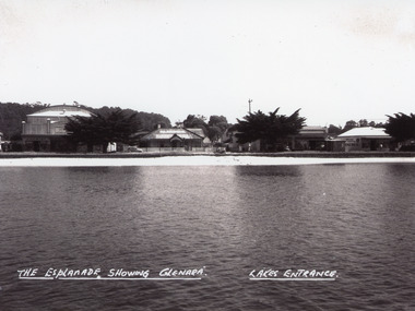 Lakes Entrance Regional Historical Society (operating as Lakes Entrance History Centre & Museum)
Photograph - Glenara Guest House, Bulmer H D, 1935c
Copy black and white photograph of a section of Esplanade, viewed from the front lake. Buildings in view are the Prince Regent Theatre including the chemist shop, the original Glenara Guest House, and shops. Lakes Entrance VictoriaThe Esplanade showing Glenara, Lakes Entrancecinema, guesthouses, township, waterfront -
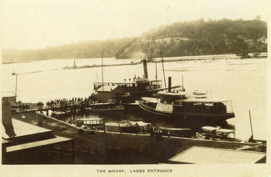 Lakes Entrance Regional Historical Society (operating as Lakes Entrance History Centre & Museum)
Photograph, 1910 c
Black and white photograph showing two steamers at New Works wharf, five or six other smaller vessels and crowds of people on wharf and steamers. Small shed on end of wharf, rooves of two buildings in foreground. Jemmys Point hill in the background and timber barrier wall for formation of Bullock Island. Lakes Entrance Victoria.The Wharf, Lakes Entranceships and shipping, township, waterways, retail trade -
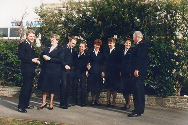 Lakes Entrance Regional Historical Society (operating as Lakes Entrance History Centre & Museum)
Photograph, 1995
After Lakes Entrance Salvation Army closed, the building became venue for Baptist Church.Colour photograph of a group of Salvation Army Cadets from Melbourne, outside the lakes Entrance Salvation Army Citadel at Lakes Entrance, Victoriabuildings, religion -
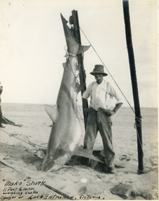 Lakes Entrance Regional Historical Society (operating as Lakes Entrance History Centre & Museum)
Photograph, 1930 c
Mako shark 11 ft 6 inch long, weighing 540 pounds, caught at Lakes Entrance, VictoriaBlack and white photograph of a mako shark on display on entrance pier, man standing beside shark. Lakes Entrance Victoriahouses, waterways, boats and boating -
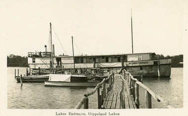 Lakes Entrance Regional Historical Society (operating as Lakes Entrance History Centre & Museum)
Postcard, 1920c
Also larger black and white copyBlack and white postcard of Baang Yarnda the converted dredge Wombat moored at jetty of Broomes Federal Guest house, photo features rustic timber jetty tourist launch and other boats, two persons standing in doorway of Baang Yarnda. Lakes Entrance VictoriaLakes Entrance Gippsland Lakesboats and boating, guesthouses -
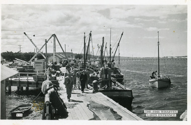 Lakes Entrance Regional Historical Society (operating as Lakes Entrance History Centre & Museum)
Photograph - Fishing Boats, 1950c
Eastern wharf colloquially known as 'Harbecks Wharf' and 'The Scallop Wharf'|One other copy same sizeBlack and white photograph of fishing boats moored at the eastern wharf. The wharf has a clutter of vehicles, a crane, ladder, fishing nets and onlookers. In left background the tops of the Great War Memorial cypress trees, right background the footbridge is seen. Lakes Entrance VictoriaThe Fish Wharves Lakes Entrance fishing industry, waterfront, boats and boating, transport, memorials -
 Lakes Entrance Regional Historical Society (operating as Lakes Entrance History Centre & Museum)
Photograph, 2000
This residence named 'Mourilyan' was built in 1892 beside Harbeck's Store, Lakes Entrance, as a family residence. It was altered and extended in 1927. In 1968 it was relocated to present site in Williams Road. The entrance steps and stonework were constructed by Rev A E Clark. Internal renovations during 1990's. Continually occupied by Harbeck family and descendents. Also a colour photograph of the front entrance of same dwelling in new location at Williams Road, Lakes Entrance.|Also one colour photograph of the front entrance of same dwelling in new location at Williams Road Lakes Entrance VictoriaBlack and white photograph of a fibro dwelling on Esplanade, beside Harbecks's Store. Lakes Entrance Victoriahouses, heritage study -
Glenelg Shire Council Cultural Collection
Photograph, Entrance Gates to Island Park Casterton, c. 1963
SOURCED FROM CASTERTON TOWN HALL (FORMER SHIRE OF GLENELG)Black and white photo showing entrance gates to Island Park CastertonBack: 'Entrance gates and track leading to oval at Island Park Casterton' - handwritten, green biro -
Lakes Entrance Regional Historical Society (operating as Lakes Entrance History Centre & Museum)
Photograph, 1955 c
Also second print taken at same time girl waving her left hand lace edge of petticoat showing 05340.1 12.5 x 9 cmBlack and white photographic proof of girl toddler seated on rug wearing check dress white cardigan white shoes and socks Lakes Entrance VictoriaBulmer Gift Salon Pty Ltd Lakes Entrancefashion -
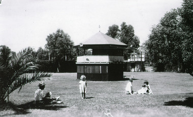 Lakes Entrance Regional Historical Society (operating as Lakes Entrance History Centre & Museum)
Photograph, Bulmer H D, 1940c
Black and white photograph showing original band rotunda, Whiters Camp Park, surrounded by manicured lawns, five people in foregound. Lakes Entrance VictoriaThe Band Rotunda, Whiters Camping Park, Lakes Entranceresort, recreation -
Ararat & District Historical Society (operating the Langi Morgala Museum)
Photograph
Old winery at Henry Duver's property at RhymneyBlack and white photo of a stone building with a pitched roof. There is a smaller entrance attached to the front of the building with an open door.Written on back: Entrance to old winery at Mr H. Duver's Rhymney -
Lakes Entrance Regional Historical Society (operating as Lakes Entrance History Centre & Museum)
Photograph, 1960 c
Compilation of photographs possibly put together by Mrs Bunty Bulmer to be used for advertisingBlack and white compilation of eight photographs showing different views of Woodbine House and cabins Lakes Entrance VictoriaWoodbine House and Holiday Park Lakes Entrance Vic Bulmer Photoaccommodation, houses -
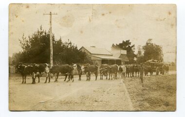 Orbost & District Historical Society
black and white photograph, 1911
This photo shows Jas Lynn of Orbost driving a team of bullocks pulling a large cart of maize. They are taking it to the fisherman's Wharf in Lakes Entrance. Maize has been grown on the Orbost flats since the late 19th century. Transport was always an obstacle to economic sucess. For a few years prior to the First World War and the construction of the railway line from Bairnsdale to Orbost, a lot of maize was carted by horse and bullock teams to Lakes Entrance for transhipment to the Melbourne market. At that .time yields of 90 to 100 bushels of maize were quite a common occurrence. James Lynn, a member of the East Gippsland Maize Board, farmed at Jarrahmond.This photograph is associated with the large maize growing industry in the Orbost region. A black / white photograph of a bullock team pulling a large, loaded cart. It is being driven by a man standing on the side of the road, holding a whip. In the background are houses and a telegraph pole.on back - " Carting maize to Lakes Entrance in 1911."transport-bullocks maize-orbost lynn-james -
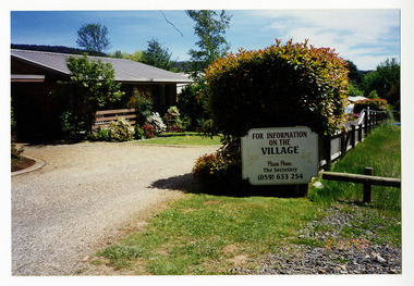 Marysville & District Historical Society
Photograph (Item) - Colour photograph, 1998
A colour photograph that shows the entrance to The Village in Marysville in Victoria.A colour photograph that shows the entrance to The Village in Marysville in Victoria. This residential village was destroyed in the 2009 Black Saturday bushfires.the village, marysville, victoria, 2009 black saturday bushfires, photograph -
Lakes Entrance Regional Historical Society (operating as Lakes Entrance History Centre & Museum)
Photograph, Rose Series, 1955 c
Also another colour postcard similar view of footbridge made by Murray Views donor Susan Samuel 2 January 2015 number 04272.1, 9 x 14 cmColour postcard taken from south end of the Cunninghame Arm footbridge showing crowd on bridge, cars parked on Esplanade, new concrete wall between dunes and lake at south end of bridge Lakes Entrance VictoriaThe Foot-Bridge, Lakes Entrance. Vicrecreation, waterfront, land reclamation -
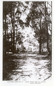 Lakes Entrance Regional Historical Society (operating as Lakes Entrance History Centre & Museum)
Photograph, 1920c
Black and white photograph of Hazel Walk and Tea Rooms at Kalimna. It shows bush track through natural vegetation leading to rustic weather board with canvas awning on the veranda side of tea rooms. Lakes Entrance VictoriaHazel Walk and Tearooms, Lakes Entrance topography, restaurant -
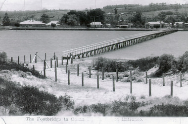 Lakes Entrance Regional Historical Society (operating as Lakes Entrance History Centre & Museum)
Photograph - Footbridge, 1937c
Two other copies 6.5 x 9 imageBlack and white photograph showing waterfront, Esplanade, some buildings and background hill almost completed footbridge across Cunninghame Arm. Posts defining pathway over sand dune to ocean beach. Lakes Entrance VictoriaFootbridge to Ocean Beach, Lakes Entrancewaterways, bridges, township -
Lakes Entrance Regional Historical Society (operating as Lakes Entrance History Centre & Museum)
Postcard, H D Bulmer, 1925 c
Black and white postcard of Lookout on Jemmys Point showing an old dead grey box tree trunk many limbs lying on ground near base trunk stabilized by two long poles straight ladder from ground to fork at top Lakes Entrance VictoriaLookout Tree Lakes Entrancejetties, waterways -
 Lakes Entrance Regional Historical Society (operating as Lakes Entrance History Centre & Museum)
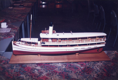
Photograph, 1998
Colin Garth spoke to Rotary Club of Lakes Entrance about his plans- in March 1998, to build replica of S S GippslandColour photograph showing model of S S Gippsland at Lakes Entrance Rotary Club , Lakes Entrance, Victoriaships and shipping, waterways, topography -
 Lakes Entrance Regional Historical Society (operating as Lakes Entrance History Centre & Museum)
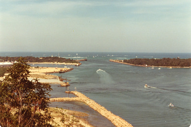
Photograph, 1979
The king of the straits, offshore powerboat race with Lakes entrance as a destination was not repeated due to adverse weather conditionsColour photograph of the entrance, Bullock Island and Reeves Channel. Taken from Jemmys Point during the King of the Strait offshore powerboat race. It also shows the built up groynes at the entrance to the North Arm. Lakes Entrance Victoriafishing industry, waterways -
 Kew Historical Society Inc
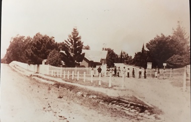
Photograph - Entrance to Boroondara General Cemetery
Boroondara Cemetery, established in 1858, is within an unusual triangular reserve bounded by High Street, Park Hill Road and Victoria Park, Kew. The caretaker's lodge and administrative office (1860 designed by Charles Vickers, additions, 1866-1899 by Albert Purchas) form a picturesque two-storey brick structure with a slate roof and clock tower. A rotunda or shelter (1890, Albert Purchas) is located in the centre of the cemetery: this has an octagonal hipped roof with fish scale slates and a decorative brick base with a tessellated floor and timber seating. The cemetery is surrounded by a 2.7 metre high ornamental red brick wall (1895-96, Albert Purchas) with some sections of vertical iron palisades between brick pillars. Albert Purchas was a prominent Melbourne architect who was the Secretary of the Melbourne General Cemetery from 1852 to 1907 and Chairman of the Boroondara Cemetery Board of Trustees from 1867 to 1909. He made a significant contribution to the design of the Boroondara Cemetery. (Source: Heritage Victoria)This photograph is one of the earliest known photographs of the cemetery, showing the early plantings and fences.Later print copy of an undated original photographic positive of the entrance to the Boroondara General (Kew) Cemetery. The Cemetery had been opened in 1855. This view is from Bulleen Road (now High Street) showing a group of 12 or 13 men standing in a line outside the entrance. At this time, the clocktower and high brick fence had not been constructed, but the trees have reached a substantial heightPencil inscription on reverse - "Boroondara Cemetery Entrance 1862"boroondara general (kew) cemetery, cemeteries -- melbourne (vic.) -
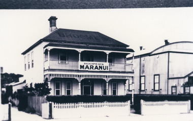 Lakes Entrance Regional Historical Society (operating as Lakes Entrance History Centre & Museum)
Photograph, 1946c
Black and white photograph of Hoopers Maranui Guest House. A timber double storied building with upstairs balcony and down stairs veranda across front, sash windows, doors with side lights and fan lights, hedge at front enclosed by picket fence. On right of photo, fibro cement Prince Regent Theatre, built 1926. Lakes Entrance VictoriaMaranui Lakes Entranceguesthouses, architecture, entertainment -
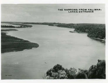 Lakes Entrance Regional Historical Society (operating as Lakes Entrance History Centre & Museum)
Postcard, Bulmer H D, 1945c
Also two other copies 6.5 x 8.5Black and white small format postcard of the Narrows, and Reeves Channel of Lake King, Gippsland Lakes, showing Rigby, Fraser and Flannagan Islands opposite the steep shoreline of the mainland. Taken from Jemmys Point. Lakes Entrance VictoriaThe Narrows from Kalimna Lakes Entranceislands, waterways, fishing industry -
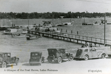 Lakes Entrance Regional Historical Society (operating as Lakes Entrance History Centre & Museum)
Photograph - Boat Harbour, 1935c
Black and white photograph of the eastern wing of the western Boat Harbour. It shows small vessels and launches moored at jetties. People on jetties and seated on shore. Four motor cars parked at the edge of the lake in foreground. Lakes Entrance VictoriaA Glimpse of the Boat Haven, Lakes Entrancejetties, boats and boating, waterfront, transport -
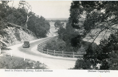 Lakes Entrance Regional Historical Society (operating as Lakes Entrance History Centre & Museum)
Postcard - Princes Highway Kalimna, Bulmer H D, 1935c
Black and white postcard of the Princes Highway as it winds around Jemmys Point. A motor car driving up the hill between steep road cutting and post and rail fence. View of the lake and ocean in the distance. Lakes Entrance VictoriaBend in Princes Highway, Lakes Entrance fences, roads and streets -
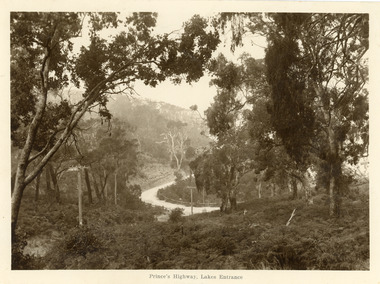 Lakes Entrance Regional Historical Society (operating as Lakes Entrance History Centre & Museum)
Postcard - Princes Highway Kalimna, 1920c
Sepia toned large format postcard of a bend in the Princes Highway at Kalimna. It shows a bracken covered hill in foreground, some larger trees, steep roadside cutting and post and rail fence at the edge of the road. Picture shows fog rising through trees. Lakes Entrance VictoriaPrinces Highway Lakes Entrance roads and streets, topography -
Lakes Entrance Regional Historical Society (operating as Lakes Entrance History Centre & Museum)
Postcard, 1920 c
Also panoramic postcard view from southern part of Rigby Island to Lakes Entrance township 04336.1, 5 x 30 cmBlack and white panoramic folding postcard of the Gippsland Lakes including Reeves Channel, Rigby Island, the entrance, Bullock Island and Lakes Entrance township taken from Jemmys Point Lakes Entrance Victoriaaccommodation, guesthouses -
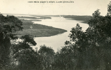 Lakes Entrance Regional Historical Society (operating as Lakes Entrance History Centre & Museum)
Postcard, Bulmer and Segerberg, 1915c
Black and white postcard of the Gippsland lakes, taken from Jemmys Point. It shows Rigby Island, Fraser Island and Flannagan Island, Reeves Channel. Natural vegetation in foreground. Lakes Entrance VictoriaView from Jimmy's Point Lakes Entranceislands, waterways, topography