Showing 427 items
matching topography
-
 Lakes Entrance Historical Society
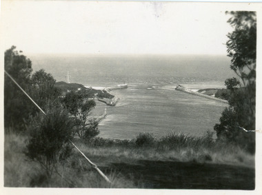
Photograph - The Entrance, 1930c
Black and white photograph showing wooden piers at entrance to Bass Strait from the Gippsland Lakeswaterways, topography, boats and boating, islands -
 Lakes Entrance Historical Society
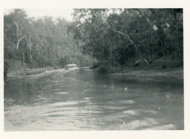
Photograph - North Arm, 1950c
Black and white photograph of a tourist launch travelling upstream between high tree covered banks on the North Arm, Lakes Entrance, Victoria. waterways, topography, tourism, boats and boating -
 Lakes Entrance Historical Society
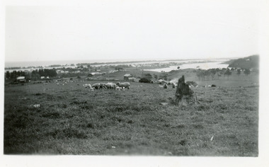
Photograph - Butcher's Paddock, Clark, Ruth, 1945c
Also second print 7 x 11.5Black and white photograph of the North Arm and township, taken from Allens Hill, looking across the Butcher's Paddock. It shows the slaughter house, sheep, lambs and other animals in the paddock. Lakes Entrance Victoriawaterways, topography, township, animals -
 Lakes Entrance Historical Society
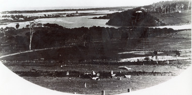
Photograph - Allen's Tearoom, 1935c
Enlarged from postcard produced for Mrs Allen to advertise Allens's Tearooms at the brow of Myer St, known as Allen's Hill.Black and white photograph of township, situated between Cunninghame Arm and North Arm. Shows cleared and fenced paddocks on eastern side of North Arm, some clearing and ring barked trees on western side, the high point sometimes referred to as Bernies Point after Bernie Sutherland, who lived and built boats here. Lakes Entrance VictoriaMrs Allens Seaview Cottage Lakes Entrancewaterways, topography, township, tearoom -
 Lakes Entrance Historical Society
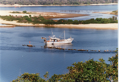
Photograph - Dredging, Tambo Shire, 1990c
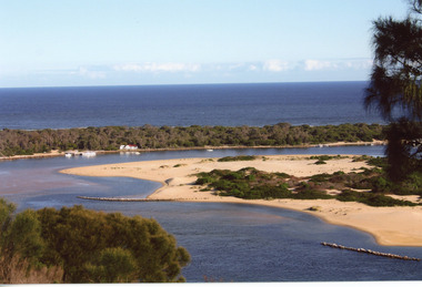
Second copyColour photograph of the south eastern shore of Rigby Island, Gippsland Lakes. It shows the scrub covered hummocks in the background, Hopetoun Channel, dumped sand which connects Snake Island and Rigby Islands, groynes into Narrows from Rigby Island. Fishing boat with scallop dredge moored in sheltered bay inside a groyne. Lakes Entrance Victoria waterways, topography, fishing industry, dredging -
 Lakes Entrance Historical Society
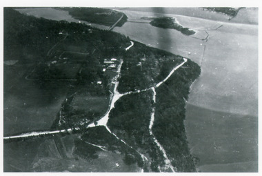
Photograph - Kalimna, Bulmer H D, 1940c
Black and white photograph of aerial view of Kalimna escarpment, Princes Highway, road to Kalimna Hotel, scattering of buildings including Gainsborough House, in distance is North Arm bridge, footbridge to undeveloped Bullock Island with rock groynes in place. Part of eastern pier of entrance at Lakes Entrance, Victoria. waterways, topography, township, bridges -
 Lakes Entrance Historical Society
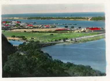
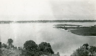
Photograph - Lakes Entrance, 1940c
Black and white photograph of the township from the North Arm. It shows the calm waters between steep shorelines covered in natural vegetation and scrub. Lakes Entrance VictoriaLakes Entrance from the North Armvegetation, topography, waterways, township -
 Lakes Entrance Historical Society
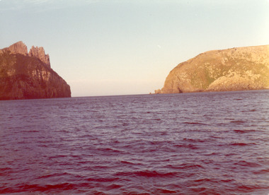
Photograph, 1975
Also three same size similar photographsColour photograph of the Hippolite Rocks on the south east coast of Tasmania, taken from the fishing boat Minawie. Tasmaniafishing industry, boats and boating, topography, ocean -
 Lakes Entrance Historical Society
Postcard - Township, 1998c
Tinted small format postcard showing the township situated on the isthmus between two stretches of water the Cunninghame Arm and the North Arm. Work in progress widening the North Arm Bridge as seen by workmen's huts beside the southern approach. Lakes Entrance Victoriajetties, waterways, topography, township -
 Lakes Entrance Historical Society
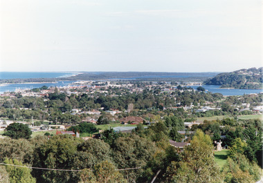
Photograph - Township, Fish, Marie, 1985c
Colour photograph of township, showing buildings, Jemmys Point, Mount Barkly, Kalimna Heights, North Arm and old North Arm bridge, and Rigby Island beyond. Sea Vista flats in foreground. Photo taken from near Telecom Tower on Merrangbaur Hill. Lakes Entrance Victoriatopography, township, waterways, bridges -
 Lakes Entrance Historical Society
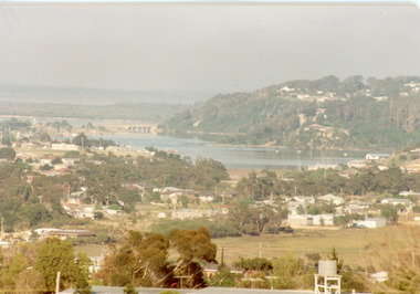
Photograph - Township, Fish, Marie, 1985c
Colour photograph of part of township showing Jemmys Point, Mount Barkly, Kalimna Heights, North Arm & old North Arm bridge, looking beyond to Rigby Island. Photo taken from near Telecom Tower on Merrangbaur Hill. Lakes Entrance Victoriatopography, township, waterways, bridges -
 Lakes Entrance Historical Society
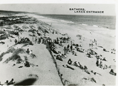
Postcard - Ocean Beach, 1950c
2 other copiesBlack and white small format postcard of bathers at the ocean beach. It shows a crowd of people on the sand dunes, remains of a brush fence, Southern Ocean and Red Bluff in distance. Taken from original tower, built for Royal Lifesaving Club. Lakes Entrance VictoriaBathers, Lakes Entrance topography, people, beaches, recreation -
 Lakes Entrance Historical Society
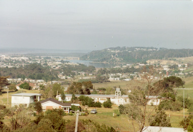
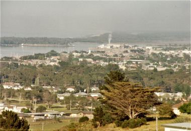
Photograph - Township, Tambo Shire, 1990c
Also second copy photographic enlargements of significant sites in the Tambo ShireColor photograph of the township, showing a distant view of the Ninety Mile Beach, the Gippsland Lakes and islands, Kalimna Heights, the bridge over the North Arm, Cunninghame Arm, and a broad view of the town and tree lined streets. Lakes Entrance Victoriabridges, topography, township, waterways -
 Lakes Entrance Historical Society
Photograph - Township, Fish Marie, 1985c
Colour photograph of township, showing building on Bullock Island, Cunningham Arm and small white shed on old New Works Jetty near the entrance, view towards the barrier. Photo taken from near telecom tower on Merrangbaur Hill 1985c. Lakes Entrance Victoriatopography, township, waterways, bridges -
 Lakes Entrance Historical Society
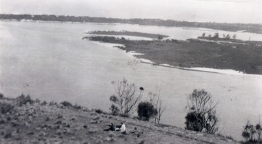
Photograph - Snake Island, 1930c
Black and white photograph, showing eastern end of Rigby Island, Snake Island, at Lakes Entrance, Victoria. Reeves Channel below foreground hill, Hopetoun Channel between dunes and islands with fish pens in distance. Two people sitting on hill in foreground.islands, waterways, topography, room display -
 Lakes Entrance Historical Society
Photograph - Snake Island, 1930c
Black and white photograph, showing eastern end of Rigby Island, Snake Island, at Lakes Entrance, VictoriaColour photograph, showing eastern end of Rigby Island, Snake Island, at Lakes Entrance, Victoriaislands, waterways, topography, room display -
 Lakes Entrance Historical Society
Photograph - Snake Island, 1930c
Black and white photograph, showing eastern end of Rigby Island, Snake Island, at Lakes Entrance, VictoriaBlack and white photograph, showing eastern end of Rigby Island, Snake Island, at Lakes Entrance, Victoriaislands, waterways, topography, room display -
 Lakes Entrance Historical Society
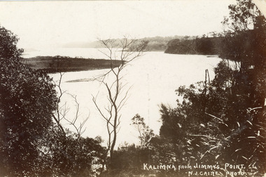
Postcard - Reeves Channel, Caire Nicholas John, 1905c
Also black and white enlargement 16 x 25Black and white postcard of the lake below Jemmys Point, Gippsland Lakes, showing Rigby Island opposite the steep cliffs of Kalimna and Nungurner shores of lakes. Small island, known as the Doughboy of Rigby Island. View taken from Jemmys Point with natural vegetation in foreground. Lakes Entrance VictoriaKalimna from Jimmys Pointislands, waterways, topography, boats and boating -
 Lakes Entrance Historical Society
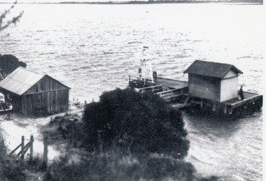
Photograph - Nungurner Jetty, 1938
Reprinted from Rev. Alfred Maher's photo album, Anglican Church Archives, Sale, VictoriaBlack and white photograph of Nyerimilang Jetty, Gippsland Lakes. It shows a short jetty with boat landing, navigation light and storage shed on jetty, boatshed on bank. Small motor car beside boat shed. Distant view across lake to eastern point of Flanagan Island, Fraser Island and Rigby Island. Lakes Entrance Victoriajetties, boats and boating, waterways, topography -
 Lakes Entrance Historical Society
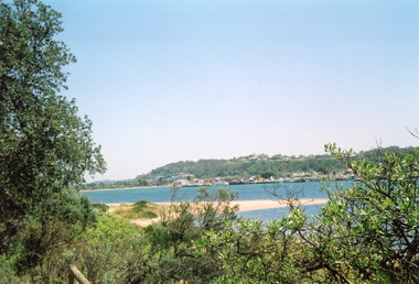
Photograph - Lakes Entrance, Davies, Judy, 2005c
Colour photograph of Jemmys Point, Kalimna Heights, and the Western end of the township, taken from the southern shore of Cunninghame Arm. Small sand spit and natural vegetation in foreground. Lakes Entrance Victoriajetties, waterways, topography, township -
 Lakes Entrance Historical Society
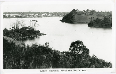
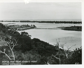
Postcard - North Arm, Valentine Series, 1930c
This is the before paired photograph used in the 150 year Lakes Entrance 1858-2008 display.|The after paired photograph number is 01590.1 Also one 12 x 16 framed photograph used in room display.Black and white small format postcard of North Arm and Cunninghame Arm of Gippsland Lakes, taken from Jemmys Point, Club Hotel at western end of town, bridge to Bullock Island, scrub covered hummocks and Bass Strait in distance. Lakes Entrance VictoriaNorth Arm from Jemmys Point Lakes Entrancebridges, islands, waterways, topography -
 Lakes Entrance Historical Society
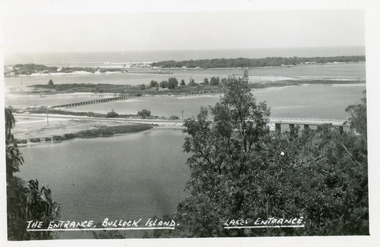
Postcard - Bullock Island, The Lakes Studio, 1920c
One black and white copy 17 x 25Black and white postcard showing North Arm Bridge, Bullock Island and foot bridge northern end of piers at entrance to Bass Strait and sand dunes. Left foreground shows power pole and water bore and telephone poles along Princes Highway Lakes Entrance Victoria.The Entrance, Bullock Island, Lakes Entranceislands, bridges, waterways, topography -
 Lakes Entrance Historical Society
Photograph - Bullock Island, Fraser Ian, 1975c
Color photograph of the eastern part of Bullock Island, showing buildings of Lakes Entrance Fishing Co-Operative and PWD, spit opposite Club Hotel has been sown with grass, hummocks and Bass Strait in distance. Taken from Seaview Parade Kalimna. Lakes Entrance Victoriawaterways, islands, land reclamation, topography -
 Lakes Entrance Historical Society
Photograph - New Works, Phillips, Miss L, 1900c
Also other black and white copy 9 x 14 cm, donated by Russell Goff with inscription The TownSepia photograph showing view from the dunes across lake, and Cunninghame Arm, to township. Foreground shows dense vegetation on dunes behind two houses, harbour engineer's house on left and contractor John Carpenter's house on right. Lakes Entrance Victoriawaterways, township, boats and boating, topography -
 Lakes Entrance Historical Society
Photograph - New Works, 1905c
Also black and white copy 10 x 16.5|Also sepia toned postcard damagedBlack and white photograph showing view from New Works across lake, and Cunninghame Arm. Foreground shows two children on boardwalk, roofs of harbour masters and harbour engineers houses, and the house of the contractor John Carpenter. Smoke billowing from funnel of S S Wyralla. Lakes Entrance Victoriajetties, waterways, township, topography -
 Lakes Entrance Historical Society
Photograph - Carpentertown, Phillips Miss L, 1910c
Two other black and white copies, one 9 x 14 cm, second 11 x 21.5 cmSepia photograph showing houses on dunes at New Works. House on right is harbour engineer's house, next Carpenter house, PWD jetty in front. Lakes Entrance Victoriajetties, houses, boats and boating, topography -
 Lakes Entrance Historical Society
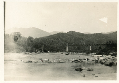
Photograph - Bridges
Black and white photograph showing partially built McKillops Bridge on Snowy River, East Gippsland, Victoria.Cantilever new bridge over Snowy River at McKillops Crossing, 45 feet above recorded flood, washed away before officially opened, decking, etc, down stream more than a mile. (on back)bridges, waterways, topography, construction -
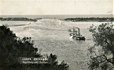 Lakes Entrance Historical Society
Photograph - The Entrance, Segerberg and Bulmer, 1910 c
Also enlargement 17 x 23 cmBlack and white photograph showing view from Jemmys Point of the entrance to the Gippsland Lakes from Bass Strait. Pioneer dredge in centre foreground, and steamer JCD. Cottages and works buildings including Rocket shed on eastern dunes, Schnapper Cottage on far right western dune. Rock groynes and tip of Bullock Island centre left. Vegetation in foreground. Lakes Entrance VictoriaLAKES ENTRANCE Segerberg and Bulmerships and shipping, topography, jetties, houses -
 Lakes Entrance Historical Society
Book, Garnet, J. Ros and Brooks, Ronald, Wilsons Promontory, 1970
A short history of Wilson's Promontory, Victoria, from its early settlement to proclamation as a National Park in 1908, and a short account of its management from that time to 1970. Illustrated with sketches.parks, topography, natural history, vegetation -
Lakes Entrance Historical Society
Book, Discovering the Prom. on Foot, 1986
A guide to 22 walks including four nature walks in Wilson's Promontory National Park. Includes photographic reproductions, maps and sketches to assist in identification of flora and fauna.parks, natural history, topography, vegetation