Showing 545 items
matching vegetation
-
 Hume City Civic Collection
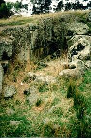
Photograph, Early 1990's
This is a photograph of one of the many stone ruins which can be seen in the Sunbury area and surrounding districts. These ruins are found in varying degrees of structural damage caused by erosion, vegetation growth and vandalism. This is the remains of a bluestone quarry on the 'Oaklands' property at Oaklands Junction.A coloured photograph in portrait format of a basalt rock ruined structure which has been dug into a hillside with a line of trees in the background.stone structures, oaklands quarry, george evans collection -
 Bendigo Military Museum
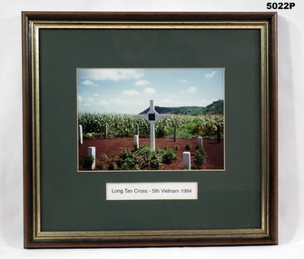
Photograph - PHOTOGRAPH, FRAMED, Long Tan Cross - South Vietnam 1994, 1994
Photograph - colour photograph of a large white upright memorial Cross surrounded by a number of smaller white memorial posts surrounded by a background of tropical vegetation. Frame - timber with decorative trim; brown stain with gold painted inner edge, glass fronted. Mount - cardboard, midgreen colour.Black print within the mount "LONG TAN CROSS - STH VIETNAM 1994". photograph, framed accessories, vietnam war, memorial -
 Lakes Entrance Regional Historical Society (operating as Lakes Entrance History Centre & Museum)
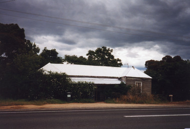
Photograph, 1999
Believed to have been built before 1900.Colour photograph of a timber building with corrugated iron hip roof. Front veranda across width of building between symmetrical projections at either corner. Surrounded by vegetation and encroached on by shrubbery. Situated on corner of Kalimna West Road and Princes Highway. Kalimna West Lakes Entrance Victoriahalls -
 Lakes Entrance Regional Historical Society (operating as Lakes Entrance History Centre & Museum)
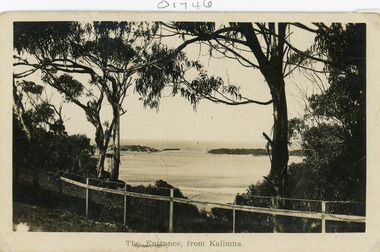
Postcard
Black and white postcard of the man made entrance through the sand hummocks, taken from Kalimna cliff top. In the foreground native vegetation on the cliff top behind simple timber and wire netting boundary fence topped with a single strand of barbed wire. Lakes Entrance VictoriaThe Entrance from Kalimnawaterways, topography, houses, islands -
 Lakes Entrance Regional Historical Society (operating as Lakes Entrance History Centre & Museum)
Photograph, 1920c
Copied from a copy in possession of J WhadcoatBlack and white photograph showing view of seven cottages on dunes. View of several boats at jetties and on slipway, white shed on New Works wharf, Cunninghame Arm in front of cottages, part of Bullock Island showing some vegetation and one telegraph pole. Lakes Entrance Victoriawaterways, jetties, islands, accommodation -
 Kew Historical Society Inc
Photograph - Yarra River, Kew, 1924
Henry Beater Christian (1886-1962) , was a descendant of one of the earliest settler families in Kew. Employed at the Kew Asylum as a 'public servant', he was a skilled amateur photographer, photographing numerous scenes in Kew and on his travels around Victoria. The majority of his photographs date from 1916 to 1929. His finest photographs are housed in two photograph albums. A dated early photograph of the Yarra River at Kew.Digital copy of a photograph from page 1 of the 47-page photograph album containing 261 gelatinous silver images, loaned by Diane Washfold with permission given to digitise and hold a copy in our collection. The image is a closeup view of the Yarra at Kew, with introduced vegetation (willows) on the bank."Yarra River Kew 1924"henry beater christian (1886-1962), landscape photography, kew (vic.) — yarra river, christian-washfold collection, photograph albums -
 Beechworth Honey Archive
Hand-Written Notes by Frank Lebbell Frost [ca 1915-1924]
Hand-written notes on vegetation and flowering quality. Includes the areas of Rutherglen, Chiltern, Beechworth, Barnawartha, Yackandanda. Includes the trees Yellow Box, Iron Bark, Red Box, Cape Weed, Green Cabbage Box, Stringy Bark and Hill Gum. Written with black ink on paper.hand written, hand-written, notes, flowering, eucalypts, gum, trees, frost, beekeeper, beechworth honey -
University of Melbourne, Burnley Campus Archives
Plan, Circus Site, c. 1990
(1) Copy of Plan: City of Richmond City Engineers Department Circus Site: includes Descriptions of Site Preparation, Plant List and Plant Order List. (2) On tracing paper: Plant Plan. (3) On tracing paper: "Yarra Vegetation Survey - Site 3," Plant Plan(1) Handwritten on reverse, "Richmond Council - Yarra Blvd to Bridge Road."circus, survey -
 Victorian Aboriginal Corporation for Languages
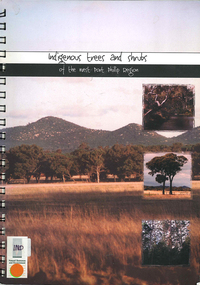
Book, Elise Jeffery, Indigenous trees and shrubs of the west Port Phillip region, 2000
A series of information sheets on the west Port Phillip region, divided into zones, giving a guide to the tree and shrub species that occurred in those areas and where in the landscape they occurred.maps, b&w photographs, colour photographs, illustrations, word lists, wall mapindigenous plants, vegetation, species guide, revegetation -
Lakes Entrance Regional Historical Society (operating as Lakes Entrance History Centre & Museum)
Book, Land Conservation Council Victoria Gippsland Lakes Hinterland Area, 1982
Report describing the physical nature of the land in the Gippsland Lakes (Victoria) Hinterland Study area. History, climate, geomorphology, land use, flora and fauna are presented. 1 map in pocket.waterways, gippsland, natural history, vegetation -
Lakes Entrance Regional Historical Society (operating as Lakes Entrance History Centre & Museum)
Book, Land Conservation Council Victoria South Gippsland Area District 2, 1980
Report describing and assessing the natural resources of the public land in the South Gippsland (Victoria) Study Area 2, comprising the Latrobe Valley, Strzelecki Range, South Gippsland coastal plains and all of Wilson's Promontory. History, Geology, floRuth Clarkgippsland, topography, natural history, vegetation -
Lakes Entrance Regional Historical Society (operating as Lakes Entrance History Centre & Museum)
Book, Discovering the Prom. on Foot, 1986
A guide to 22 walks including four nature walks in Wilson's Promontory National Park. Includes photographic reproductions, maps and sketches to assist in identification of flora and fauna.parks, natural history, topography, vegetation -
Lakes Entrance Regional Historical Society (operating as Lakes Entrance History Centre & Museum)
Book, Garnet, J. Ros and Brooks, Ronald, Wilsons Promontory, 1970
A short history of Wilson's Promontory, Victoria, from its early settlement to proclamation as a National Park in 1908, and a short account of its management from that time to 1970. Illustrated with sketches.parks, topography, natural history, vegetation -
 Lakes Entrance Regional Historical Society (operating as Lakes Entrance History Centre & Museum)
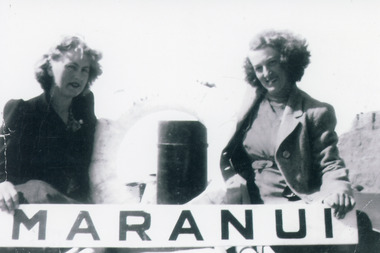
Photograph, 1940 c
Black and white photograph of two young women on board tourist launch Maranui 2 at Lakes Entrance, Victoria.vegetation, waterways, boats and boating, tourism -
 Lakes Entrance Regional Historical Society (operating as Lakes Entrance History Centre & Museum)
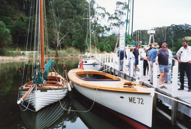
Photograph, 1996
Date made 19 October 1996Colour photograph showing restored and reberthed launch Maranui at Metung Hot Pools Jetty in Chinaman's Creek, registered vessel no. ME72, white clinker built sailing boat on left and white trailer sailer at rear of Maranui. Visitors on jetty. Metung Victoriavegetation, waterways, boats and boating, tourism -
 Lakes Entrance Regional Historical Society (operating as Lakes Entrance History Centre & Museum)
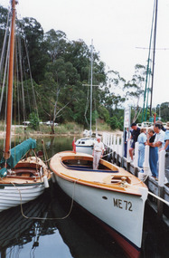
Photograph, 1997
Date made 19 October 1997Colour photograph showing restored and reberthed launch Maranui at Metung Hot Pools Jetty in Chinaman's Creek, registered vessel no. ME72, white clinker built sailing boat on left and white trailer sailer at rear of Maranui. Visitors on jetty. Metung Victoriavegetation, waterways, boats and boating, tourism -
 Lakes Entrance Regional Historical Society (operating as Lakes Entrance History Centre & Museum)
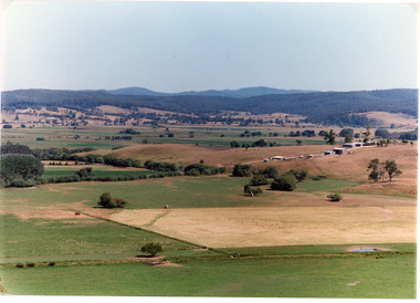
Photograph, Tambo Shire, 1994
Also second identical copyColour photograph of the Mossiface Flats, near Bruthen, shows paddocks of the rich river flats, timbered foothills in the distance, with mountain range behind. Some paddocks have been mown for grass hay. Farm buildings in foreground and background. Dam in foreground. Bruthen Victoriaanimals, agriculture, vegetation, topography -
 Lakes Entrance Regional Historical Society (operating as Lakes Entrance History Centre & Museum)
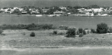
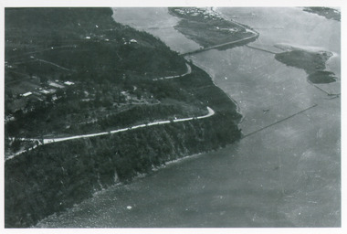
Photograph, Bulmer H D, 1940c
Black and white photograph of aerial view of Kalimna Heights, showing scattered buildings, Princes Highway around side of cliff, western end of township, North Arm bridge, footbridge to Bullock Island, and rock groynes. Track to lookout and signal beacon visible. Lakes Entrance Victoriaboats and boating, jetties, waterways, vegetation -
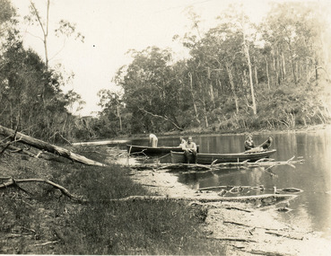 Lakes Entrance Regional Historical Society (operating as Lakes Entrance History Centre & Museum)
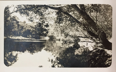
Photograph, 1950c
Black and white photograph of the narrow upper reaches of the North Arm. It shows four people and dog at two small boats on bank. Steep tree covered hillsides above sandy shoreline. Lakes Entrance Victoriarestaurant, vegetation, waterways, tourism -
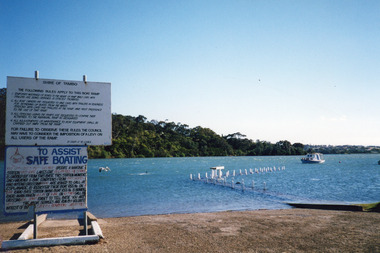 Lakes Entrance Regional Historical Society (operating as Lakes Entrance History Centre & Museum)
Photograph, Holding M, 2000
Date made January 2000Colour photograph of high tide in the North Arm. It shows the boat ramp and jetty under water, boat moored in lake, pelican fishing nearby. Warning and instruction signs on shore. Kalimna Heights in background. Lakes Entrance Victoriaboats and boating, vegetation, waterways, topography -
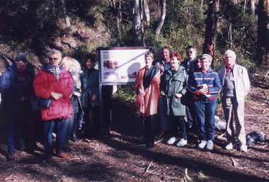 Lakes Entrance Regional Historical Society (operating as Lakes Entrance History Centre & Museum)
Photograph, 1998
Date made June 1998Colour photograph of a group of people at an interpretative sign at the opening of the Mississippi Creek walking track project at Colquhoun Forest, Lakes Entrance, Victoria.vegetation, waterways, topography, public works -
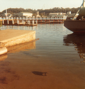
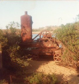 Lakes Entrance Regional Historical Society (operating as Lakes Entrance History Centre & Museum)
Photograph, Goff, Russell, 1989c
Small format photograph showing rusted travelling crane at entrance piers. Steam boiler still attached. Lakes Entrance Victoriajetties, vegetation, waterways, boats and boating -
 Lakes Entrance Regional Historical Society (operating as Lakes Entrance History Centre & Museum)
Photograph, Fraser, Nancy, 1983c
from Nan Fraser's albumColour photograph showing new jetty under construction at New Works area, Lakes Entrance, Victoria.vegetation, boats and boating, jetties, ocean -
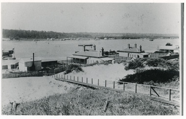 Lakes Entrance Regional Historical Society (operating as Lakes Entrance History Centre & Museum)
Photograph, 1900c
Also four other black and white copies, one size 12 x 18 cm, two size 9 x 14 cm, and one size 10 x 15 cm, one of which was purchased from Helen ClothierBlack and white photograph showing buildings on dunes, and township of Lakes Entrance across lake, Cunninghame Arm. Buildings from left are school, harbour masters house, harbour engineer's house. Boardwalk in foreground. Kalimna Hill in background. Lakes Entrance Victoriawaterways, vegetation, topography, township -
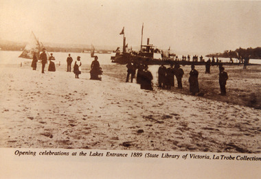 Lakes Entrance Regional Historical Society (operating as Lakes Entrance History Centre & Museum)
Photograph, Eastwood Bros, 1889c
Two other copies in good order - b & w 14 x 20 cm, black and white 20 x 25.5 cm both have tear marksSepia photograph showing steamers at wharf near newly opened Entrance. People on steamers and wharf and on beach. Town on left background hummocks on right background. Steamer on end of wharf is PS Nell, other steamer SS Dargo?. Two small sailing boats on lake. Lakes Entrance VictoriaOpening celebrations at the Lakes Entrance 1889 (State Library of Victoria, LaTrobe Collection)fences, vegetation, houses, waterfront -
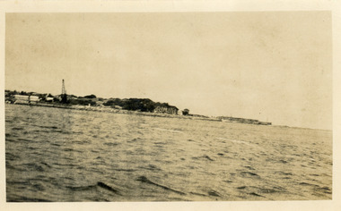 Lakes Entrance Regional Historical Society (operating as Lakes Entrance History Centre & Museum)
Photograph, 1925c
Also black and white print 10 x 17.5 cmBlack and white photograph showing Eastern Pier and Entrance to Gippsland Lakes from Bass Strait. Works machinery, buildings, cranes etc still in place. Lakes Entrance Victoriajetties, houses, vegetation, waterfront -
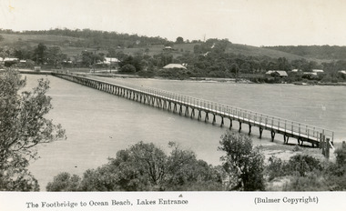 Lakes Entrance Regional Historical Society (operating as Lakes Entrance History Centre & Museum)
Postcard, 1937c
Copies as follows|One Miniture postcard tinted 6.5 x 9|One Black and white copy 6.5 x 11|One Tinted copy 20 x 28|One Postcard 17 x 12Black and white postcard showing waterfront, some buildings along esplanade, no buildings on Myer St Hill. Footbridge across Cunninghame Arm completed to high tide mark, ramp constructed later, scrub in foreground. Lakes Entrance VictoriaThe Footbridge to Ocean Beach Lakes Entrancevegetation, bridges, waterways, township -
 Lakes Entrance Regional Historical Society (operating as Lakes Entrance History Centre & Museum)
Photograph, Lakes Post Newspaper, 1993
The Warm Holes are the remnants of Reeves River, the original waterway of the natural entrance to the Gippsland Lakes.Black and white photograph of the fourth warm hole, looking eastward, Lakes Entrance, Victoria.roads and streets, waterways, islands, vegetation -
 Lakes Entrance Regional Historical Society (operating as Lakes Entrance History Centre & Museum)
Postcard, Bulmer H D, 1950c
Also one other postcard same donated by M & V Carpenter in spares box.Black and white postcard of the Princes Highway Jemmys Point, showing Bullock Island between North Arm and Cunninghame Arm, distant view of the entrance from Bass Strait to the Gippsland Lakes. Post and rail fence along roadside. Lakes Entrance VictoriaPrinces Highway and a view of the Entranceguesthouses, restaurant, vegetation, tearoom -
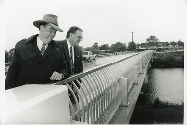 Lakes Entrance Regional Historical Society (operating as Lakes Entrance History Centre & Museum)
Photograph, Lakes Post Newspaper, 1995
The first concrete bridge built over Tambo River at Swan Reach, in 1932 was never officially opened, so the opening of the refurbished bridge on 19 December 1995 was declared 'The Official Opening'. Photo taken at the Official Opening 19 December 1995Black and white photograph showing David Treasure, MLA, and Norm Butler of VicRoads, on the strengthened and widened bridge, over the Tambo River at Swan Reach, Victoria.bridges, waterways, animals, vegetation