Showing 1625 items
matching yarra river
-
 Kew Historical Society Inc
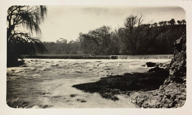
Photograph - Dight's Falls, 1924
... kew (vic.) — yarra river..., Henry Christian, is of Dight's Falls on the Yarra River from... christian (1886-1962) landscape photography kew (vic.) — yarra river ...Henry Beater Christian (1886-1962) , was a descendant of one of the earliest settler families in Kew. Employed at the Kew Asylum as a 'public servant', he was a skilled amateur photographer, photographing numerous scenes in Kew and on his travels around Victoria. The majority of his photographs date from 1916 to 1929. His finest photographs are housed in two photograph albums. Digital copy of a photograph from page 9 of the 47-page photograph album containing 261 gelatinous silver images, loaned by Diane Washfold with permission given to digitise and hold a copy in our collection. The point-of-view selected by the photographer, Henry Christian, is of Dight's Falls on the Yarra River from the Kew side. Dight's Falls separates the saline and fresh water sections of the river. "Studley Park / Kew"henry beater christian (1886-1962), landscape photography, kew (vic.) — yarra river, christian-washfold collection, photograph albums, yarra river -- studley park (vic.), dight's falls -
 Port Melbourne Historical & Preservation Society
Photograph - Aerial view of the mouth of the Yarra from Williamstown, 2006
... yarra river...B&W aerial photographic view of the mouth of the Yarra... and wharves - webb dock yarra river garden city fishermans bend ...B&W aerial photographic view of the mouth of the Yarra River, taken from above Williamstown and looking east. Greenwich Bay and the cooling water outlet for Newport Power Station in the foreground, the entrance and Webb Dock in the centre, Sandridge Beach and the city upper right.piers and wharves - webb dock, yarra river, garden city, fishermans bend, newport power station -
 Kew Historical Society Inc
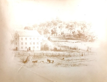
Print, Sands & Kenny, Dights Mill, 1856
... yarra river... included 26 acres of land along the Yarra River for £481... wood engraving, showing Dights Mill and Falls on the River... acres of land along the Yarra River for £481 at the Port Phillip ..."In 1839 John Dight purchased Melbourne block 88, which included 26 acres of land along the Yarra River for £481 at the Port Phillip land sales held in Sydney. Dight was already in the business of flour milling and had a mill near Campbell Town in New South Wales called ‘Ceres’. In April 1840, he notified his customers through The Sydney Herald that he was leaving to go to Port Phillip. The first steam powered flour mill was constructed in Melbourne in 1841. Dight built his water powered mill, soon after, from bricks bought over from Tasmania. Dight used the river to power his mill: Water flowed along an inlet channel to turn an undershot water wheel. In order to regulate flow or to ensure flow for times when river levels were low, Dight constructed a rough stone weir." (Melbourne Water)Dights Mill. Reproduction of a book plate from an original wood engraving, showing Dights Mill and Falls on the River Yarra. The image was originally published in Sands & Kenny, Melbourne & Sydney.Annotation on reverse: "Dights Flour".dights mill, yarra river -
 University of Melbourne, Burnley Campus Archives
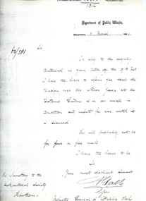
Letter, Department of Public Works, 11/3/1864
... yarra river...Letter re unsafe state of bridge over Yarra River... Yarra River This is a photocopy of the original letter which ...Letter re unsafe state of bridge over Yarra River This is a photocopy of the original letter which was written by A. Gable (?) on behalf of the Inspector General of Public Works. It comments on the unsafe state of the bridge over the Yarra River by the Botanic Gardens. Provided by Diane Nicholas Librarian at Hawthorn Library 1994Letter from Department of Public Works to Secretary of Horticultural Societybridge, yarra river, unsafe bridge, bridge safety melbourne, bridge safety 1800s, a. gable, inspector general of public works -
 Greensborough Historical Society
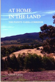
Book, Geoff Lacey, At home in the land: the Plenty-Yarra corridor, 2021
... yarra river... the corridors of the Plenty and Yarra rivers, their history, development... of the the landscape along the corridors of the Plenty and Yarra rivers ...111 p., paperback, col. photographs, mapsnon-fictionindigenous plants, indigenous fauna, plenty river, yarra river -
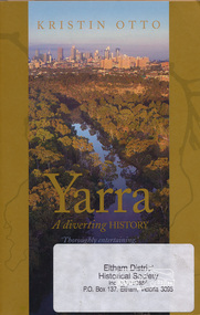 Eltham District Historical Society Inc
Book, Text Publishing, Yarra: a diverting history by Kristin Otto, 2009
... yarra river...Exploration of the history and meaning of Melbourne's Yarra... Yarra river and those who have lived and worked on it. yarra ...Exploration of the history and meaning of Melbourne's Yarra river and those who have lived and worked on it. Softcover, 245 p. : ill. maps, ports. ISBN 9781921520006yarra river -
 Kew Historical Society Inc
Photograph - Flooding of the Yarra Valley at Kew East, 1974
... yarra river... of the Yarra River are recorded to have occurred in 1891, 1901, 1916... by overflowing water in Glass' Creek and the River Yarra. ..., was a regular occurrence. Extreme flood events of the Yarra River ...Flooding of the Yarra Valley, including that section of the Yarra bordering Kew and Kew East in the north and west of the municipality, was a regular occurrence. Extreme flood events of the Yarra River are recorded to have occurred in 1891, 1901, 1916, 1923 and 1934. The Municipality of Kew's response to these floods was to enact planning decisions restricting residential development in flood prone areas following the floods of 1916, 1921 and 1934. While floods continued after the development of the Upper Yarra Reservoir (construction 1948-57), the regularity and extent of these inundations diminished. During the nineteenth century, the land abutting the south side of the Yarra in Kew was devoted to dairy farming. In the twentieth century, before and after the construction of the Eastern Freeway, much of this low-lying area was used as golf courses and public parks.Late example of the capacity of the Yarra Valley at Kew to flood, even though drainage works and the Upper Yarra Reservoir had reduced their regularity.Original black and white print photograph of Hay's Paddock under floodwater on 16 May 1974. The vantage point of the photographer is Keystone Crescent looking east. Flooding was caused by overflowing water in Glass' Creek and the River Yarra. Annotation verso: "Keystone Cr looking east / 16 May 1974 11.50am"hays paddock, floods, yarra river, glass' creek -
Kew Historical Society Inc
Collection, Floods in North Kew (Series), 1929–1934
... Yarra River -- North Kew... of the Yarra River are recorded to have occurred in 1891, 1901, 1916... by different hands, of the flooding of the River Yarra in North Kew..., was a regular occurrence. Extreme flood events of the Yarra River ...Flooding of the Yarra Valley, including that section of the Yarra bordering Kew and Kew East in the north and west of the municipality, was a regular occurrence. Extreme flood events of the Yarra River are recorded to have occurred in 1891, 1901, 1916, 1923 and 1934. The Municipality of Kew's response to these floods was to enact planning decisions restricting residential development in flood prone areas following the floods of 1916, 1921 and 1934. While floods continued after the development of the Upper Yarra Reservoir (construction 1948-57), the regularity and extent of these inundations diminished. Natural disasters had an impact on the development and settlement of Melbourne and its suburbs. Flooding in the Melbourne region was a regular event in the nineteenth and for most of the twentieth centuries. Changes in the impact of natural disasters could occur due to a number of factors. This collection of small snapshots, mostly taken from Kellett Grove in North Kew, provide provenanced evidence of flooding in the area before the development of the unnatural flood barrier that is the Eastern Freeway.Collection of 16 monochrome photographs, annotated on verso by different hands, of the flooding of the River Yarra in North Kew in the third and fourth decades of the twentieth century [1920s & 1930s]. Individual photos include the dates of different floods. Many of the photos were taken from the rear of 8 Kellett Grove; a house still extant in 2023yarra river -- north kew, floods -- yarra valley, floods -- north kew, floods -- 1929, floods -- 1934, natural disasters -- kew -
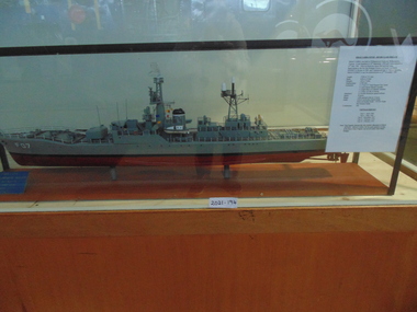 National Vietnam Veterans Museum (NVVM)
Model, HMAS Yarra FO7/45 - River Class Frigate
... HMAS Yarra FO7/45 - River Class Frigate...A moded of HMAS Yarra F07/45 River Class Frigate under... Cerberus Collection A moded of HMAS Yarra F07/45 River Class ...A moded of HMAS Yarra F07/45 River Class Frigate under glass cover.Made in Williamstown and lauched on the 30th September 1958. It was decommisioned on the 22nd January 1985hmas yarra, model, cerberus collection -
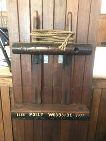 Mission to Seafarers Victoria
Equipment - Belaying pin, Polly Woodside - 1885-1977, 1885-1977
... yarra river... now berthed on the Yarra River...., ship now berthed on the Yarra River. The Polly Woodside ...Belaying pins used on the Polly Woodside, former Rona, ship now berthed on the Yarra River.The Polly Woodside was saved in the 1970s and use as a Maritime Museum until its collection was dispersed. Now one of the National Trust assets. Some Mission's volunteers were also part of the team of volunteers restoring the Polly Woodside in the 1970s.Painted: 1885 POLLY WOODSIDE 1977polly woodside, rona, yarra river, national trust, interest group -
 Kew Historical Society Inc
Photograph - Flooding of the Yarra Valley at Kew East, 1974
... yarra river... of the Yarra River are recorded to have occurred in 1891, 1901, 1916... by overflowing water in Glass' Creek and the River Yarra. ..., was a regular occurrence. Extreme flood events of the Yarra River ...Flooding of the Yarra Valley, including that section of the Yarra bordering Kew and Kew East in the north and west of the municipality, was a regular occurrence. Extreme flood events of the Yarra River are recorded to have occurred in 1891, 1901, 1916, 1923 and 1934. The Municipality of Kew's response to these floods was to enact planning decisions restricting residential development in flood prone areas following the floods of 1916, 1921 and 1934. While floods continued after the development of the Upper Yarra Reservoir (construction 1948-57), the regularity and extent of these inundations diminished. During the nineteenth century, the land abutting the south side of the Yarra in Kew was devoted to dairy farming. In the twentieth century, before and after the construction of the Eastern Freeway, much of this low-lying area was used as golf courses and public parks.Late example of the capacity of the Yarra Valley at Kew to flood, even though drainage works and the Upper Yarra Reservoir had reduced their regularity.Original black and white print photograph of the low-lying land at East Kew under floodwater on 16 May 1974. The vantage point of the photographer is Lister Street. Flooding was caused by overflowing water in Glass' Creek and the River Yarra. Annotation verso: "Lister Street looking north / Flood level / 16 May 1974 11.30am / R.L. 46.04"hays paddock, floods, yarra river, glass' creek, lister street -
 Kew Historical Society Inc
Photograph - Flooding of the Yarra Valley at Kew East, 1974
... yarra river... of the Yarra River are recorded to have occurred in 1891, 1901, 1916... by overflowing water in Glass' Creek and the River Yarra. ..., was a regular occurrence. Extreme flood events of the Yarra River ...Flooding of the Yarra Valley, including that section of the Yarra bordering Kew and Kew East in the north and west of the municipality, was a regular occurrence. Extreme flood events of the Yarra River are recorded to have occurred in 1891, 1901, 1916, 1923 and 1934. The Municipality of Kew's response to these floods was to enact planning decisions restricting residential development in flood prone areas following the floods of 1916, 1921 and 1934. While floods continued after the development of the Upper Yarra Reservoir (construction 1948-57), the regularity and extent of these inundations diminished. During the nineteenth century, the land abutting the south side of the Yarra in Kew was devoted to dairy farming. In the twentieth century, before and after the construction of the Eastern Freeway, much of this low-lying area was used as golf courses and public parks.Late example of the capacity of the Yarra Valley at Kew to flood, even though drainage works and the Upper Yarra Reservoir had reduced their regularity.Original black and white print photograph of the low-lying land at East Kew under floodwater on 16 May 1974. The vantage point of the photographer is Lister Street. Flooding was caused by overflowing water in Glass' Creek and the River Yarra. Annotation verso: "Lister St looking same as No.3 / 16 May 1974 11.30"floods, yarra river, glass' creek, lister street -
 University of Melbourne, Burnley Campus Archives
Photograph - Black and white print, Aerial View of Burnley Campus c. 1930, c. 1934
... yarra river.... Enlargements. (A) Heyington Bridge to South, Yarra River on North side... Boulevard Richmond melbourne heyington bridge yarra river aerial ...Black and white photographs. Aerial Views of Burnley Campus. Enlargements. (A) Heyington Bridge to South, Yarra River on North side. (B) Heyington Bridge at top of photograph i.e. reverse view of (A). (C) Original of (B) mounted on board. Probably taken at the time of the floods of 30 November 1934. heyington bridge, yarra river, aerial view, burnley campus, 1934 flood -
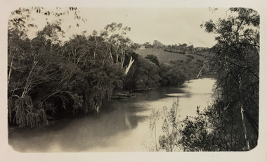
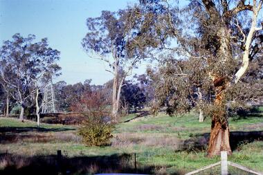 Greensborough Historical Society
Slide - Photograph, John Ramsdale, Near the confluence of the Plenty and Yarra Rivers, Lower Plenty: Slide 118, 1990s
... yarra river.... This is near the confluence of the Plenty and Yarra Rivers, Lower... and Yarra Rivers, Lower Plenty Part of the John Ramsdale collection ...Photograph shows a rural scene with gumtrees and pylon. This is near the confluence of the Plenty and Yarra Rivers, Lower PlentyPart of the John Ramsdale collection of slides and audio visual material.Colour photograph scanned from slide.No maker's marks. No caption on slide.yarra river, plenty river, lower plenty -
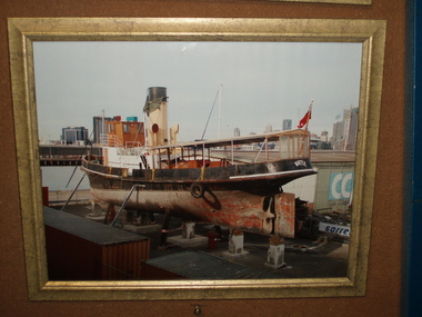 Bay Steamers Maritime Museum
Photograph - Framed Photograph, S.T.Wattle up on blocks at 19 South Wharf at commencement of restoration. October 2009, 10/2009
... river yarra... viewed from her port quarter and facing the Yarra River.... steamers maritime museum river yarra port of melbourne Coloured ...Beginning of the long-awaited restoration by Bay Steamers volunteers. A very significant moment in the life of the Wattle as this was the first day of the major restoration project that commenced in October 2009 and continued to 2020. Prior to this restoration project there was a long lead up to find funding and resources to restore the Wattle and ensure that the ship was not scrapped. The majority of this preparation and restoration work was and continues to be completed by volunteers. Photograph shows the state of the vessel up on blocks and prior to the start of hull restoration in October 2009.Coloured photograph in gilded wooden frame shows Wattle viewed from her port quarter and facing the Yarra River.steamer wattle, steam tug, wattle, restoration, volunteers, bay steamers maritime museum, river yarra, port of melbourne -
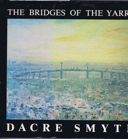 Greensborough Historical Society
Book, The Bridges of the Yarra: a book of paintings, poetry and prose, by Dacre Smyth, 1980_
... yarra river... the Yarra River, with accompanying poems and historical notes... of paintings of bridges over the Yarra River, with accompanying poems ...Unpaged, dustjacket, colour illustrationsyarra river, bridges, dacre smyth, poetry, paintings -
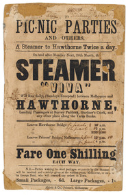 Parliament of Victoria
Flyer for the steamer Viva, Abbott & Co., Printers, c.1860
... yarra river... on the Yarra River between Princes Bridge and Hawthorn Bridge from 1860... that ran on the Yarra River between Princes Bridge and Hawthorn ...The "Viva" was a steamboat operated by George Dent that ran on the Yarra River between Princes Bridge and Hawthorn Bridge from 1860-1861. Printer flyer pasted onto cardboard advertising ferry services between Melbourne and Hawthorne [sic]. Corrections to ferry departure times are in black handwritten ink. Flyer has losses around edges and stains from 'blue-tack' verso. Black ink, printed recto: "PIC-NIC PARTIES/ AND OTHERS./ A Steamer to Hawthorne Twice a day./ On and after Monday Next, 26th march, the/ STEAMER/ "VIVA"/ Will Run daily, (Sundays Excepted) between Melbourne and/ HAWTHORNE,/ Landing Passengers at Survey Paddock, Gardner's Creek, and/ any other place along the Yarra Banks./ Leavers Hawthorne Bridge 10 a.m./ 2 p.m./ 5.30 p.m./ Leaves Princes' Bridge, melbourne 12 p.m./ 4 p.m./ Fare One Shilling/ EACH WAY./ N.B.-Parties wishing to send packages or parcels by the Steamer th(?).../ will be received and a receipt given at the waiting room, Melbourne, or on board.../ by George Dent, who will execute any orders in Town./ Small Packages, - 6d. Large Packages, - 1s/ Abbot & Co., Printers, Melbourne.viva steamboat, dent, george, hawthorne, yarra river, princes bridge, melbourne, survey paddock, gardner's creek -
 Kew Historical Society Inc
Photograph - Flooding of the Yarra Valley at Kew East, 1974
... yarra river... of the Yarra River are recorded to have occurred in 1891, 1901, 1916... by overflowing water in Glass' Creek and the River Yarra. ..., was a regular occurrence. Extreme flood events of the Yarra River ...Flooding of the Yarra Valley, including that section of the Yarra bordering Kew and Kew East in the north and west of the municipality, was a regular occurrence. Extreme flood events of the Yarra River are recorded to have occurred in 1891, 1901, 1916, 1923 and 1934. The Municipality of Kew's response to these floods was to enact planning decisions restricting residential development in flood prone areas following the floods of 1916, 1921 and 1934. While floods continued after the development of the Upper Yarra Reservoir (construction 1948-57), the regularity and extent of these inundations diminished. During the nineteenth century, the land abutting the south side of the Yarra in Kew was devoted to dairy farming. In the twentieth century, before and after the construction of the Eastern Freeway, much of this low-lying area was used as golf courses and public parks.Late example of the capacity of the Yarra Valley at Kew to flood, even though drainage works and the Upper Yarra Reservoir had reduced their regularity.Original black and white print photograph of the low-lying land at East Kew under floodwater on 16 May 1974. The vantage point of the photographer is Lister Street. In the photo, the fences of the Kilby Farm can be seen. Flooding was caused by overflowing water in Glass' Creek and the River Yarra. Annotation verso: "Hay's Paddock op No.30 Lister Street / 16 May 1974 11.50am / R.L. 46.04"hays paddock, floods, yarra river, glass' creek, lister street -
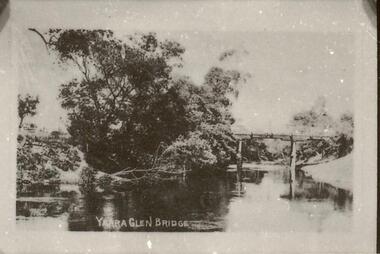 Yarra Glen & District Historical Society
Sepia postcards, Yarra Glen bridge
... yarra river...Photograph of wooden bridge over the Yarra River taken from...-ranges yarra river post and rail fence wooden bridge river ...Photograph of wooden bridge over the Yarra River taken from a point just north of the river crossing at Yarra Glen early 20th century. The town of Yarra Glen is to the right (out of frame). A post and rail fence indicates the road to Yering and Lilydale to the east of the bridge. A bend of the river is in the foreground and trees line the eastern bank.On back of postcard at the top "POST CARD". On the left hand side "THIS SPACE MAY BE USED FOR PRINTED OR WRITTEN MATTER". On the right hand side "ONLY THE ADDRESS TO BE WRITTEN HERE". In a box in the right hand corner "A HALF-PENNY STAMP TO BE PLACED HERE". Along the left hand margin "Ajax series. Printed in England" yarra river, post and rail fence, wooden bridge, river crossing, river bridge, yarra glen bridge, yering -
 Kew Historical Society Inc
Photograph - Flooding of shared path at rear of Guide Dogs Victoria, 1993
... yarra river -- floods -- kew (vic.)... the land, designated as parkland which adjoins the Yarra River. ..., designated as parkland which adjoins the Yarra River. yarra river ...The land currently occupied by Guide Dogs Victoria was once part of the grounds of the Kew Lunatic Asylum. This includes the land, designated as parkland which adjoins the Yarra River. Original colour small format polaroid photograph of flooding in parkland at the rear of Guide Dogs Victoria in the area now used as the Main Yarra Trail; taken on 16 September 1993."Flooding of shared path on 16.9.93 / Rains 15.9.93 - rear Guide Dogs [Victoria] land"yarra river -- floods -- kew (vic.), guide dogs victoria, main yarra trail, chandler park -
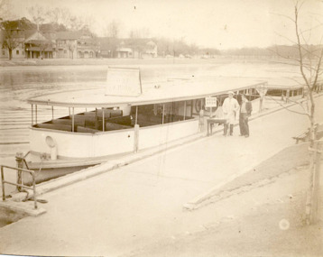 Kew Historical Society Inc
Photograph - Hicks Bros Launch at Princess Walk, circa 1953
... yarra river... and Yarra Rivers in Melbourne were a major tourist attraction... by Hicks Bros on the River Yarra at Princess Walk. Two employees... Commercially-operated boat tours on the Maribyrnong and Yarra Rivers ...Commercially-operated boat tours on the Maribyrnong and Yarra Rivers in Melbourne were a major tourist attraction, especially in the first half of the twentieth century. A number of companies ran ferries and motor-launches to locations such as the Riverview Tea Gardens (1909-1947) at Ascot Vale, and the Hawthorn Tea Gardens on the corner of Power Street and Riversdale Road. One of the families which ran these services was Hicks Bros, which from circa 1921 operated a ferry service from Princess Walk (Melbourne) to Studley Park. This is one of a series of 17 black and white undated photographic proofs donated to the Kew Historical Society in 2013 by the Queenscliffe Historical Museum. The series includes images of individuals, tea rooms, ferries, motor launches, ocean liners and tugs. In 1953, the owner of Hicks Bros was involved in an inquest into the drowning of a Ukrainian tourist on a ferry operated by Melbourne Ferries, a rival firm. In published reports of the inquest, reference is made to a number of photographs taken by Robert Irvine Atchison, part-owner of Hicks Bros. As the reverse of the photographs indicates copyright is held by the State of Victoria, the collection may have derived from that year.Historically significant and rare image of one of the major tour boat services which operated on the Yarra River.Faded black and white photographic proof of a ferry owned by Hicks Bros on the River Yarra at Princess Walk. Two employees stand beside the first of a number of wooden ferries. On the south side of the river, there are the pavilions of a number of boat clubs.ferries, motor launches, yarra river, maribyrnong river, studley park, princess walk, riverview tea gardens, hawthorn tea gardens, tourism - melbourne (vic.), hicks bros, hicks bros launches -
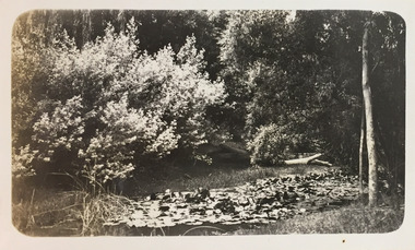 Kew Historical Society Inc
Photograph - Macauley's, Kew, 1924
... kew (vic.) — yarra river... at Macauley's boat sheds on the Yarra River at Kew. The boat sheds were... christian (1886-1962) landscape photography kew (vic.) — yarra river ...Henry Beater Christian (1886-1962) , was a descendant of one of the earliest settler families in Kew. Employed at the Kew Asylum as a 'public servant', he was a skilled amateur photographer, photographing numerous scenes in Kew and on his travels around Victoria. The majority of his photographs date from 1916 to 1929. His finest photographs are housed in two photograph albums. Digital copy of a photograph from page 2 of the 47-page photograph album containing 261 gelatinous silver images, loaned by Diane Washfold with permission given to digitise and hold a copy in our collection. The photograph is of waterlilies planted at Macauley's boat sheds on the Yarra River at Kew. The boat sheds were located at the west end of Molesworth Street. "Macauley’s Kew"henry beater christian (1886-1962), landscape photography, kew (vic.) — yarra river, christian-washfold collection, photograph albums, macauley's boat sheds -
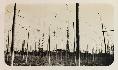 Kew Historical Society Inc
Photograph - Yarra at Kew, 1925
... kew (vic.) — yarra river... the Yarra River was used.... christian (1886-1962) landscape photography kew (vic.) — yarra river ...Henry Beater Christian (1886-1962) , was a descendant of one of the earliest settler families in Kew. Employed at the Kew Asylum as a 'public servant', he was a skilled amateur photographer, photographing numerous scenes in Kew and on his travels around Victoria. The majority of his photographs date from 1916 to 1929. His finest photographs are housed in two photograph albums. Digital copy of a photograph from page 4 of the 47-page photograph album containing 261 gelatinous silver images, loaned by Diane Washfold with permission given to digitise and hold a copy in our collection. This photograph of hop farming coveys the various uses for which low lying fertile flood prone land beside the Yarra River was used."Yarra at Kew"henry beater christian (1886-1962), landscape photography, kew (vic.) — yarra river, christian-washfold collection, photograph albums, agriculture, hop farms -
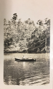 Kew Historical Society Inc
Photograph - Orlando Christian, 1924
... kew (vic.) — yarra river... in our collection. This is a photograph of the Yarra River at Kew... christian (1886-1962) landscape photography kew (vic.) — yarra river ...Henry Beater Christian (1886-1962) , was a descendant of one of the earliest settler families in Kew. Employed at the Kew Asylum as a 'public servant', he was a skilled amateur photographer, photographing numerous scenes in Kew and on his travels around Victoria. The majority of his photographs date from 1916 to 1929. His finest photographs are housed in two photograph albums. Digital copy of a photograph from page 6 of the 47-page photograph album containing 261 gelatinous silver images, loaned by Diane Washfold with permission given to digitise and hold a copy in our collection. This is a photograph of the Yarra River at Kew. The focus of the view is Orlando Henry Beater Christian in his row boat. Orlando was a founder of the Willsmere Swimming Club. "Yarra Rvr /Kew"henry beater christian (1886-1962), landscape photography, kew (vic.) — yarra river, christian-washfold collection, photograph albums, orlando henry beater christian -
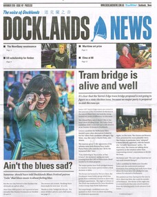 Melbourne Tram Museum
Newspaper, Docklands News, "Tram bridge is alive and well", Nov. 2018
... Yarra River... construction of a tramway bridge over the Yarra River in the Docklands... Trams tramways Docklands New Tramway Bridges Yarra River ...Newspaper clipping from "Docklands News" - December 2018, No. 147, titled "Tram bridge is alive and well" about the possible construction of a tramway bridge over the Yarra River in the Docklands, Yarra Edge district and the relationship with the Vic. State election that was held on 24/11/2018. Clipping spreads over three pages. Discusses other election issues.trams, tramways, docklands, new tramway, bridges, yarra river -
 Kew Historical Society Inc
Photograph - Yarra Bend and Kew Asylum, 1924
... kew (vic.) — yarra river... of the Yarra Bend Asylum looking across the Yarra River to the Kew... christian (1886-1962) landscape photography kew (vic.) — yarra river ...Henry Beater Christian (1886-1962) , was a descendant of one of the earliest settler families in Kew. Employed at the Kew Asylum as a 'public servant', he was a skilled amateur photographer, photographing numerous scenes in Kew and on his travels around Victoria. The majority of his photographs date from 1916 to 1929. His finest photographs are housed in two photograph albums. Digital copy of a photograph from page 6 of the 47-page photograph album containing 261 gelatinous silver images, loaned by Diane Washfold with permission given to digitise and hold a copy in our collection. This is a photograph of the grounds of the Yarra Bend Asylum looking across the Yarra River to the Kew Asylum on the horizon. The photograph predates the 1929 closure of the Yarra Bend Asylum. "Yarra Rvr / Kew"henry beater christian (1886-1962), landscape photography, kew (vic.) — yarra river, christian-washfold collection, photograph albums, yarra bend asylum, kew asylum, yarra bend park -
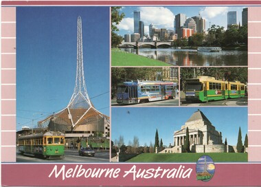 Melbourne Tram Museum
Postcard, Scancolor, Five Melbourne tram photos, early 2000's
... Yarra River... with the Arts Centre spire in the background, the view across the Yarra... Yarra River tram 1010 tram 2013 Colour postcard divided back ...Colour postcard divided back - Scancolor - titled Melbourne Australia, featuring five photographs on one card -1010 with the Arts Centre spire in the background, the view across the Yarra River, a Z3 advertising tram, B2 2013 and the Shrine of Remembrance. Back has space for name and address, stamp and a message and details of the postcard. Produced by Scan colour, possibly early 2000's.trams, tramways, postcards, w7 class, b class, z3 class, melbourne, yarra river, tram 1010, tram 2013 -
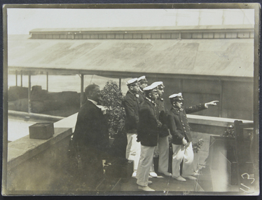 Mission to Seafarers Victoria
Photograph, Chaplain, captain and crew at the Mission, c.1915
... yarra river... towards the west of the Yarra River. In the background we can see... towards the west of the Yarra River. In the background we can see ...Reverend Gurney Goldsmith accompanied by officers are standing on the terrace of the Siddeley Street Mission and looking towards the west of the Yarra River. In the background we can see the Huddard and Parker docks on The Australian Wharf.reverend a. gurney-goldsmith, siddeley street institute, officers, docks, australian wharf, yarra river -
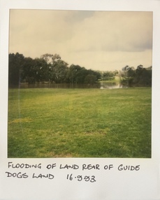 Kew Historical Society Inc
Photograph - Flooding at parkland at rear of Guide Dogs Victoria, 1993
... yarra river -- floods -- kew (vic.)... the land, designated as parkland which adjoins the Yarra River..., designated as parkland which adjoins the Yarra River. It is now ...The land currently occupied by Guide Dogs Victoria was once part of the grounds of the Kew Lunatic Asylum. This includes the land, designated as parkland which adjoins the Yarra River. It is now designated as the Chandler Park.Original colour small format polaroid photograph of flooding in parkland at the rear of Guide Dogs Victoria in the area now used as the Main Yarra Trail; taken on 16 September 1993."Flooding of land rear of Guide Dogs land 16.9.93"yarra river -- floods -- kew (vic.), guide dogs victoria, main yarra trail, chandler park -
 Kew Historical Society Inc
Photograph - Macauley's, Kew, 1924
... kew (vic.) — yarra river... in our collection. The photograph is of a stretch of the Yarra... of Macauley's boat sheds on the Yarra River at Kew. It is also one ...Henry Beater Christian (1886-1962) , was a descendant of one of the earliest settler families in Kew. Employed at the Kew Asylum as a 'public servant', he was a skilled amateur photographer, photographing numerous scenes in Kew and on his travels around Victoria. The majority of his photographs date from 1916 to 1929. His finest photographs are housed in two photograph albums. A fine, early view of Macauley's boat sheds on the Yarra River at Kew. It is also one of the earliest views of Carnsworth, a notable mansion in Studley Park. Digital copy of a photograph from page 2 of the 47-page photograph album containing 261 gelatinous silver images, loaned by Diane Washfold with permission given to digitise and hold a copy in our collection. The photograph is of a stretch of the Yarra River at Kew. In the foreground are the boats of Macauley's Boat Sheds. On the horizon is the red brick tower of J Lewis Carnegie's house 'Carnsworth' in Stawell Street. "Macauley’s Kew"henry beater christian (1886-1962), landscape photography, kew (vic.) — yarra river, christian-washfold collection, photograph albums, macauley's boat sheds, carnsworth -- stawell street -- kew (vic.)