Showing 1506 items matching "acres"
-
 Whitehorse Historical Society Inc.
Document, Luke's History, 26/11/2008
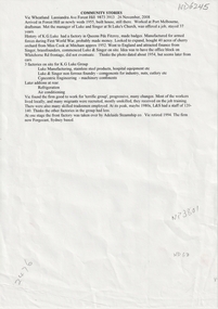
Vic Wheatland began work at Luke and Singer in 1957 and continued there until1994. He describes the K. G. Luke CompanyVic Wheatland began work at Luke and Singer in 1957 and continued there until1994. He describes the K. G. Luke Companywheatland vic, luke and singer, luke kenneth george, cook amy -
 Whitehorse Historical Society Inc.
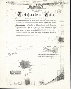
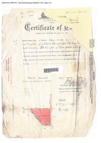
Document, Certificate of Title, 1/11/1913
Photocopy of Certificate of Title Vol 3739 Fol 747798, fifty-five acres fronting Mitcham Road, Vermont being part Crown Portion 121 at Mitcham, Parish of Nunawading, County of Bourke in the name of William George Kirkpatrick and Alfred Matthew Kirkpatrick, 1 November 1913. Transfer to Wunderlich Ltd 31 July 1928; Australian Industry Development Corporation 19 October 1983 and leased to Monier Ltd.kirkpatrick, william george, alfred matthew, wunderlich limited, monier limited, australian industry development corporation, mitcham road, vermont, land sales -
 Southern Sherbrooke Historical Society Inc.
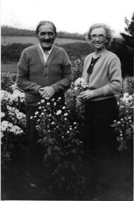
Photograph - Charles Macauley Gray & Minnie Gray
B&w photo of Charles Macauley Gray (sometimes spelled in records as Grey) and Williamina (Minnie) Gray, nee Wilson, lived on a 40-acre farm on the north-west corner of Belgrave-Hallam and Wellington Roads. They are standing among flowers and rolling hills are visible behind them. Both are wearing cardigans over casual clothes. Copy of original photo donated to our society by Kath Oram, a founding member. -
 Bendigo Historical Society Inc.
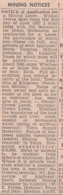
Newspaper - MINING REPORTS - NOTICE OF APPLICATION FOR A MINING LEASE
Notice of Application for a Mining Lease from the Bendigo Advertiser 8/6/1967. Proposed lease is for about 1000 acres in the Township of Kingower (Nrthern Section). Owner/occupier - Crown Land, so far as the applicant has been able to learn. Term required 15 years. Applicant was North Deborah Mining Company No Liability (W. E. Anstee, Director). Place and date: Bendigo, 5/6/67.newspaper, bendigo advertiser, mining reports, notice of application for a mining lease, north deborah mining company no liability, w e anstee -
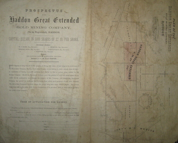 Federation University Historical Collection
Plan and Prospectus, Plan and Prospectus of the Haddon Great Extended Gold Mining Company
The Haddon Great Extended GMC was formed sometime in the 1870s for the purpose of mining 270 acres of land lying to the south-west of the Racecourse Company (who at that stage had a shaft at the depth of 86 feet)A printed piece of paper with a prospectus on the left and a plan on the right. The plan includes a shaded area representing the Haddon Great GMC, and shows neighbouring companies such as Racecourse GMC, Haddon Consols, Reform GMC, Haddon Co, and also shows Russel's Private Propert and Roach's Private Company, and the Trap-Rock Formation.haddon great extended gmc, wc elder, william levey, c thorburn, john langdon, hb forster, national bank of australasia, haddon, racecourse company, h.b. forster, w.c. elder, john langdon, william levey, c. thorburn, john langdon, shares, racecourse goldmining company, reform gold mining company, haddon consols, haddon great extended gold mining company, russell -
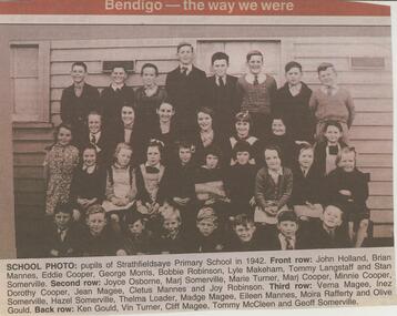 Bendigo Historical Society Inc.
Newspaper - JENNY FOLEY COLLECTION: SCHOOL PHOTO
Strathfieldsaye state School (SS1211) began in March 1873 in the Shire Hall. Five acres were gazetted for a school in January 1874 and a 3 roomed weatherboard school was built and opened in January 1875.Bendigo Advertiser ''the way we were'' from 2002. School photo: pupils of Strathfieldsaye Primary school in 1942. Front row: John Holland, Brian Mannes, Eddie Cooper, George Morris, Bobbie Robinson, Lyle Makeham, Tommy Langstaff and Stan Somerville. Second row: Joyce Osborne, Marj Somerville, Marie Turner, Marj Cooper, Minnie Cooper, Dorothy Cooper, Jean Magee, Cletus Mannes and Joy Robinson. Third row: Verna Magee, Inez Somerville, Hazel Somerville, Thelma Loader, Madge Magee, Eileen Mannes, Moira Rafferty and Olive Gould. Back row: Ken Gould, Vin Turner, Cliff Magee, Tommy McCleen and Geoff Somerville. The clip is in a folder.newspaper, bendigo advertiser, the way we were -
 Bendigo Historical Society Inc.
Document - Strathfieldsaye Primary School, 1998
Strathfieldsaye state School (SS1211) began in March 1873 in the Shire Hall. Five acres were gazetted for a school in January 1874 and a 3 roomed weatherboard school was built and opened in January 1875.Photo copied notes on the history of the Strathfieldsaye Primary School - "Back To Celebrations" A typed A4 sheet outling the history and also a photo of the school.history, bendigo, strathfieldaye primary school -
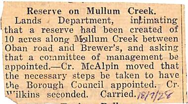 Ringwood and District Historical Society
Newspaper, Scrapbook Clipping, Library Collection, Ringwood, Victoria
Newspaper Clipping from un-named local paper re Reserve on Mullum Creek, category of PARKS, GARDENS, RESERVES. Dated 18-7-1928Lands Department, intimating that a reserve had been created of 10 acres along Mullum Creek between Oban Road and Brewer's, and asking that a committee of management be appointed. -- Cr. McAlpin moved that the necessary steps be taken to have the Borough Council appointed. Cr. Wilkins seconded. Carried. -
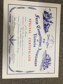 Yarrawonga and Mulwala Pioneer Museum
Prize certificate, Special certificate for Crop competition, 1963
Crop Competitions have been held at local Shows dating from late 1800’s to todayCream card red and blue print. Hand printed details of winner and description of Crop Competition. Also has tractor and plough, silos, tractor and header logos on top and wheat head logos on sides and bottom.The Farm Competitions Association of Victoria. Special Certificate awarded to J C Thom, Winner of Open Wheat Crop Competition (40 acres) 1963. Variety exhibited - Olympic. Conducted by Yarrawonga Agricultural Society Signed by Deputy Chairman JW McCann, Hon Secretary R A Andrew -
 Ringwood and District Historical Society
Document, Certificate of Title - Edward Thomas Miles, Gentleman, "Woorara", Ringwood - part of Crown Section 20, Parish of Warrandyte, County of Evelyn - 1913
A4 copies of damaged Landata Victoria Historical Search documents - Vol 3726 Fol 200 - incomplete proprietor and transfer details.Edward Thomas Miles is now the proprietor of an Estate in Fee-simple subject to the Encumbrances notified hereunder ... 27 acres 19 perches or thereabouts, together with a right of carriage way over roads coloured brown. Subdivision map includes un-named roads - western side is Wonga Road (later Warranwood Road), and eastern side is Grandview Grove (later Bemboka Road), both north of Plymouth Road, Ringwood, Vic. Transfers include (illegible) Dobbs, November, 1927 - 5 acres Harry Temple Marshall, 1st December, 1928 - 10ac 3r David Edward Meyland, 4th October, 194-? (illegible). -
 Bacchus Marsh & District Historical Society
Map, Lerderderg Park Lands sale plan. 1911
This plan was for the sale of parcels of land from the Lerderderg Park Estate property in 1911. Advertising for the sale appeared in the Bacchus Marsh Express newspaper through July of 1911. The property was situated only a few kilometers from the township of Bacchus Marsh. The agents for the sale were L. A. Fairbairn & Co.Lerderderg Park Estate was a significant and early colonial property in the Bacchus Marsh area. This plan provides details about the first time the property was subdivided for sale. It is therefore documents an important moment in the history of this property and the broader trend of the subdivision of older and larger properties in the district.A single page paper plan showing allotments of land for sale from the Lerderderg Park property owned by John Wills. The parcels of land for sale are coloured in red.The Lerderderg River and Pyke's Creek Irigation Channel shown on the plan are in blue ink. The rest of the plan is a dark cream or beige colur with the text in black ink. The plan has been extensively annotated with hand-written notes indicating the names of people who purchased the various parcels of lands and the prices paid for those lands. Part of the top of the plan containing some text appears to be missing. The plan is pasted into a bound volume containing 76 maps or plans in total. Top: Have received instructions to Sell, account Mr John Wills, his renowned LERDERDERG PARK LANDS, so well and favourably known throughout the Commonwealth. In areas from 3 acres to 1276 acres. Every lot is either rich lucerne land (or portion now under lucerne) with some higher land adjoining Railway Station, and 2 Milk factories within 2 miles, absolutely the finest land in Victoria. Bottom: THIS IS THE FIRST SUBDIVISIONAL SALE of Rich Flats in Bacchus Marsh since the Pyke's Creek Scheme, and every lot is commanded by it. Only 32 miles from Melbourne.bacchus marsh victoria maps, land sales, lerderderg park estate, land subdivision -
 Kiewa Valley Historical Society
Newspaper Article - Thomas Briggs, 5th March 1988
Thomas Briggs was a pioneer of the Tawonga District. He worked on his parent's farm, selling goods, droving pigs and travelling to Yackandandah and Bright. He worked with pick and shovel on the Tawonga to Bright Road in 1902. He took up 320 acres of wild forest in Tawonga at 10 cents per acre per year for 20 years. He built a slab and shingle hut and a boundary fence. In 1886 he married Annie Maria Platt parenting 5 sons and 2 daughters until Annie died in 1953, aged 86 years.Thomas Briggs was a pioneer living in the Kiewa Valley with his parents and then with wife and family. This article is a history of his life from 1862 until 1887. See KVHS 0850 for information on the dray used to make the Tawonga Gap road - owned by John Briggs.Newspaper article Page 34 Border Morning Mail, Saturday, March 5, 1988 - Thomas Briggs Born 3rd Nov. 1862 who lived with his family at Upper Gundowring. His travels in the area including the Tawonga Gap and its construction in 1902 and his taking up of land in Tawonga in 1880. The article finishes in 1887 when he married Annie Maria Platt. The Thos Briggs story continues next week.thomas briggs; tawonga; kiewa valley; annie platt -
 Learmonth and District Historical Society Inc.
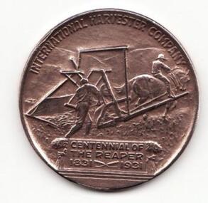
Medal - Centennial of the reaper. 1931, Commemorative Coin
International Harvester Co. medal commemorating the centennial of the 'Reaper' harvester. Issued in 1931, it names Cyrus Hall McCormick as inventor of the Reaper. Son of a Virginian farmer, he developed his father's earlier ideas into a viable harvesting machine capable of harvesting up to fifteen acres of wheat and other grains each day. Without it, only three acres could be cut. McCormick established a manufacturing business that quickly became one of the leading industrial companies in the United States. After his death the compnay merged with several competitors to form the International Harvester Co.This medal commemorates the centennial of the reaper by the International Harvester Company in America and aboard.A round medal made of copper with the face of Cyrus Hall McCormick on the frontObverse - Bust of McCormick wearing coat and bow-tie facing left; above are the words, CYRUS . HALL . McCORMICK, on the left 1808 / 1884, on the right the words, INVENTOR / OF THE / REAPER. Reverse - A horse-drawn reaper working right, with the words above, INTERNATIONAL HARVESTOR COMPANY; below, CENTENNIAL OF / THE REAPER / 1831 1931.centennial, cyrus hall mccormick, international harvester -
 Stawell Historical Society Inc
Photograph, Ledcourt Home Station in the Grampians 1866
Ledcourt Home Station Grampians. Part of a collection of Photographs by Mr. O.G. Armstrong as commissioned by the Shire of Stawell for the Inter-colonial and Paris Exhibition in Melbourne in 1866. This was one of, if not the first, Squatters Sheep Station in this region. The first licence of Ledcourt was granted to Robert Briggs in about 1840. In 1842 the run passed to Benjamin Boyd of Whaling and Boydtown Banking fame in NSW. He held it for six years. It was then taken over by Thomas Young and John Carfrae, who divided it into 3 holdings. Ledcourt 74,500 acres, Newington 74,500 acres and Swinton, 52,000 acres. It again changed hands in 1859, this time to Henry Alfred and Joseph De Little. It has changed hands several times since and in later years owned by the Cooper family and now the Marr family. The date of the actual building is uncertain, but it is known that the stone used in the building was carted from the Mount Difficult area in the Grampians and some of the courtyard paving shows convict origin. Looking up hill with Homestead on left and stone stables or right.stawell -
Ringwood and District Historical Society
Work on paper, Draft of 'Wielands of Heathmont' History of the family. Published 2008 by Don Talbot and Pat Talbot
The Wieland family were orcharding pioneers in Ringwood., Carl Ferdinand Wieland arrived in Heathmont in 1872 where he took up 50 acres, 37 perches of Crown Land.for the cost of 49 pounds.Typed pages , photographs,family group records all collected for the book. -
Hume City Civic Collection
Photograph, Rupertswood Gardens
The gardens in the photograph are in the grounds at Rupertswood, the former summer residence of Sir William John and Lady Janet Clarke. Originally the gardens covered 99 acres and included a man-made lake in the shape of a map of Australia.A non-digital black and white photograph with a cream border of the lake and gardens in a spacious area with smaller buildings in the distanc.gardens, william sangster, sir william john clarke, lady janet clarke, trees, salesian college -
 Mt Dandenong & District Historical Society Inc.
Photograph, Miss Daisy Rowse
Photograph of Daisy Rowse, daughter of settler W. Rowse who purchased the Richardson home and sixty surrounding acres when the Richardsons left the district c1913. Daisy Rowse married Hubert Jeeves in 1926. Black and white head portrait of young woman wearing a white blouse with her hair worn up.daisy rowse -
 Emerald Museum & Nobelius Heritage Park
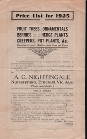
Pamphlet, Price List for 1925, A.G. Nightingale, Nurseryman, Emerald, Vic, About 1925
Nursery owned by Alfred George Nightingale, who originally worked for Nobelius Nurseries. Nightingale Nursery sold fruit and ornamental trees and delivered to Emerald Railway Station. The nurseries covered an area of 50 acres.Part of the horticultural history of Emerald and the surrounding district.Four page, cream coloured pamphlet with black printing. Contains price lists for fruit trees, ornamentals, berries, hedge plants, creepers and pot plants.a.g.nightingale, emerald -
 Bendigo Historical Society Inc.
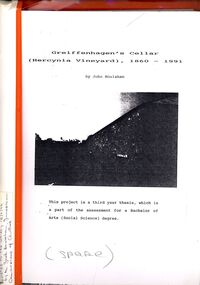
Book - STRAUCH COLLECTION: GREIFFENHAGENS CELLAR (HERCYNIA VINEYARD)
"Hercynia" was the largest vineyyard in the Bendigo District. It was started by Carl Wilhelm Greiffenhagen (William) and his cousins, twins, Carl and August Heine. The first vine cuttings were planted in 1860. The partners owned 300 acres at Axe Creek and in 1862 had 24 acres under vines and an orchard of 4 acres. By 1884 they had expanded to 30 acres of vines. They produced many award winning wines. August Heine ( 1832 - 1898) was born in Germany and came to Australia in 1854 with his twin brother Carl and their cousin William Greiffenhagen. Initially the three took up mining successfully but then the partnership bought 300 acres at Axe Creek and planted a vineyard. They also grew fruit and crops to feed the working horses. In 1870 August sold his interest in the vineyard and set up his own smaller vineyard at Sheepwash Gully. He had several business interests before he took up the caretaker position at the newly dug Weeroona lake, a position he held until his death. Carl Heine sold his interest in the vineyard in 1873 and returned to Germany. WIlliam Grieffenhagen (1834-1916) continued his very successful vineyard until the region was hit with a highly infectious vine disease in 1893. Although his own vines escaped infection, he was within the 2 mile quarantine area and was forced to dig out all his vines. He never replanted but depended on his orchard instead. He was a founding member of the Bendigo Agricultural Society and a local Shire councillor for several years. In 1870 he married Margaret Boyd.Binder containing information relating to Greiffenhagen's cellar (Hercynia Vineyard) 1860 - 1991 including black and white photographs & maps, compiled by John Houlahan as a third year thesis whichnis pat of the assessment for a Bachelor of Arts (Social Science) degree. Donated to the German Society 15/2/96 by the Grandfather of author Jack Houlahan.John Houlahanbook, bendigo, wineries, bendigo-history-axe creek- wineries- german -
 Glen Eira Historical Society
Album - Album page, Labassa, 4 Manor Grove, Circa 1972
This photograph is part of the Caulfield Historical Album 1972. This album was created in approximately 1972 as part of a project by the Caulfield Historical Society to assist in identifying buildings worthy of preservation. The album is related to a Survey the Caulfield Historical Society developed in collaboration with the National Trust of Australia (Victoria) and Caulfield City Council to identify historic buildings within the City of Caulfield that warranted the protection of a National Trust Classification. Principal photographer thought to be Trevor Hart, member of Caulfield Historical Society. Most photographs were taken between 1966-1972 with a small number of photographs being older and from unknown sources. All photographs are black and white except where stated, with 386 photographs over 198 pages. HISTORY:-- From Victorian Heritage Database citation for Labassa https://vhd.heritagecouncil.vic.gov.au/places/278 as at (26/10/2020) Labassa, Caulfield is one of Melbourne's most lavishly decorated nineteenth century mansions. It resulted from the extensive remodelling in 1890, of an earlier house, known as Sylliott Hill, which was begun in 1862-3 for lawyer, Richard A. Billing. The land at the corner of Balaclava and Orrong Roads was first acquired in 1854 by William Lyall, transferred to his partner, John Mickle, in 1859, who also acquired the adjoining allotment in Balaclava Road, and the three allotments were conveyed to Billing. His first eight-roomed house was extended significantly in 1873 into a twenty-roomed house by architects Crouch and Wilson, who were possibly also responsible for the first house. This reflected Billing's success as a barrister, and he resided at this property until his death in 1882. In 1883 prominent Melbourne businessman, Alexander William Robertson, leased the Sylliott Hill property from Billing's widow, and in 1885 he purchased the adjoining allotment in Balaclava Road. He purchased the Billing's property in 1887 and renamed the 6.31 hectare property, Ontario. In 1889-90, Robertson commissioned the German born architect, John A. B. Koch, to extensively remodel the house into a thirty-five roomed mansion. The existing house was extended and altered, largely resulting in the nineteenth century mansion as it now appears. After Robertson's death in 1896, the house was tenanted until it was eventually sold to the mining millionaire, John Boyd Watson, in 1904. He renamed the property Labassa and carried out repair and re-decoration work to the house. In the early twentieth century, many large estates were subdivided into smaller allotments as the demand for land grew and it became difficult to maintain such large estates. After Watson's death in 1911, portions of the Labassa estate were offered for sale, with Mrs Watson retaining a 1.73 hectare portion containing the house. In 1913 forty-six allotments were auctioned at Labassa Estate, with the formation of Labassa Grove and Ontario Street to the east of the property. Labassa was first recorded as containing flats in 1923 and in the late 1920s, the owner, Robert Hannon, built a red brick block of flats adjacent to the house. Subdivision continued, until the National Trust of Australia (Victoria) purchased the house in 1980 and subsequently purchased adjoining sites, one to the south-east in 1984 (house demolished in 1988) and to the west in 1988. Labassa as it now stands is substantially as it appeared when Koch completed the work in 1890. The original two storey house was transformed into a French Renaissance style mansion, with the addition of a two level L-shaped arcaded verandah and two prominent terminating bays to the south and the east. The building is of unpainted cement render with dressed bluestone plinths, balustraded parapet and steep, slate covered, flat topped mansard roofs behind. A truncated conical roof is a feature of the south bay and a helmeted head is incorporated in the parapet over the east bay. The main south and east facades incorporate many cast cement details, including sculptures, elaborate cornices, swagged Corinthian columns and caryatid consoles flanking the entrance porch, as well as pink marble panels and imitation marble, or scagliola, on curved surfaces. At the rear of the building is a two storey wing and a single storey cottage, the former being connected to the main house by a tower. This section of the house was constructed in 1873. The estate at its peak included stables (1873), conservatory (probably 1890) and a tennis pavilion (probably 1890). All of these outbuildings survive, with the stables and conservatory being converted for residential use after 1922. Internally a range of decorative treatments remain from the late nineteenth century and the early twentieth century, both from the Robertson and Watson periods of occupancy. These include wallpapers, ceiling decoration, chimney pieces, mouldings, joinery and decorative glass.From Victorian Heritage Database citation for H0135 Labassa 2/2A Manor Grove Caulfield North https://vhd.heritagecouncil.vic.gov.au/places/278 as at (26/10/2020) HOW IS IT SIGNIFICANT? Labassa, Caulfield is of architectural, aesthetic and historical significance to the State of Victoria. WHY IS IT SIGNIFICANT? Labassa, Caulfield is of architectural significance as the most prominent example of a small number of houses built in Australia in the French Renaissance style. It is of further note due to the German interpretation of the style and the use of Hellenistic sources, via Germany. It is exceptional for its lavish treatment externally, including marble, scagliola, caryatids, swagged columns, mansard roofs and ornamental cresting. Labassa is of architectural significance as the most important surviving example of German architect, John Koch's domestic work. He undertook a large variety of work in Melbourne, including a number of houses, however Labassa is the most lavish example of his work. Labassa is of aesthetic significance for its outstanding assemblage of late nineteenth and early twentieth century European style interior decoration, which remain remarkably intact. These include a trompe l'oeil ceiling, painted ceilings, embossed imitation leather and other papers, chimney pieces, ceramic tilework, oak parquetry and stained glass, including a tripartite window by Ferguson and Urie, probably dating from the 1873 period. Labassa is of historical significance as an illustrative example of the wealth acquired by a number of prominent Victorian families in the second half of the 19th century. The early development of the property, Sylliott Hill, was due to the wealth acquired by Richard Billing, barrister and fifth Victorian to be appointed Queen's Counsel in 1878. The significant development in 1890 of Ontario, is illustrative of the wealth of Alexander Robertson, a partner in Cobb and Co., a director of Goldsborough Mort & Co., and a pastoral speculator. John B. Watson, whose father had acquired great wealth from the goldfields of Bendigo and subsequently invested in city and country properties, was the third resident to impact on the house, particularly the interiors. The Labassa estate is of historical significance as an illustrative example of the development that occurred in such suburbs as Caulfield in the 1880s due to the land boom, its proximity to Melbourne and the establishment of the Melbourne to Gippsland railway in 1879. It is also illustrative of an estate which succumbed to the pressures of subdividing in the early twentieth century, as properties became difficult to maintain and demand for land close to the city grew. It was typically divided into flats in the 1920s and was used as such for about sixty years. It is of historical significance for its associations with the remnants of the earlier estate which remain extant. These include the stables, conservatory (H2005) and tennis pavilion which all remain on separate sites. Also significant are the remains of early electrical wiring and fittings. Labassa was one of the first houses in Caulfield to be electrified and some of the original wires remain. [Online Data Upgrade Project 2004]Page 129 of Photograph Album with three landscape photographs of Labassa. One of the photographs is of Labassa's drive and gates.Handwritten: 4 JUNE 1910 / SALE JUNE 28 1910 "LA BASSA' / "AUSTRALASIAN" FORMERLY "ONTARIO"/ RES OF JOHN B WATSON / 15 ACRES 3 ROADS [under bottom left photo] / 4 JUNE 1910 [under bottom right photo] / 129 [bottom left]trevor hart, bracketed eaves, intricate lacework, slate roof, bay windows, decorative brackets, caulfield north, labassa, richard a. billing, balaclava road, orrong road, sylliott hill, william lyall, crouch and wilson, alexander william robertson, ontario, 1880's, john a. b. koch, mansion, john boyd watson, labassa grove, french renaissance style, l-shaped arcaded verandah, bluestone plinths, balustraded parapet, flat topped mansard roofs, conical roof, elaborate cornices, corinthian columns, caryatid consoles, marble panels, imitation marble, scagliola, tower, conservatory, stables, tennis pavilion, mouldings, decorative glass, caryatids, swagged columns, ornamental cresting, trompe l'oeil ceiling, embossed imitation leather, oak parquetry, stained glass, tripartite window, triple window, ferguson and urie, 1870's, flats, 1920's, electric wiring, 1860's, verandahs, curved windows, arched windows, italianate, terraces, gargoyles, ornamentation, ornate entrance, la bassa, manor grove, st kilda east, gates, cast iron work, richard billing, architects, john koch, electrification, victorian style, drives, john mickle, land subdivision, mrs watson, labassa estate, robert hannon, national trust of australia (victoria), sculpture -
Whitehorse Historical Society Inc.
Document, Robert Collier Land, 1903
50 acres and house in Canterbury Road Blackburn to I.N. Cuttle for (pounds)590Papers relating to land dealings by Robert Collier of Springvale Road Tunstall. 50 acres and house in Canterbury Road Blackburn to I.N. Cuttle for (pounds)590collier, robert, t.r.b morton & coghill, maddock & jamison, canterbury road blackburn, freehold investment company of australia ltd -
 Kiewa Valley Historical Society
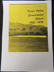
Booklet - Kiewa Valley Consolidated School x5, Kiewa Valley Consolidated School 1953 - 1974
Kiewa Valley Consolidated School was established in 1953 combining Dederang North, Kergunyah, Gundowring, Kiewa, Gundowring Upper, Red Bluff, Charleroi and Gundowing North schools on a 10 acre site with 11 rooms at Kiewa.The above schools are in the Kiewa Valley. The date and number of combined schools give insight into the change in population and families in the Kiewa Valley before and after 1953.Five A4 photocopied pages of a yellow and black booklet including the first 9 pages.kiewa valley consolidated school; dederang; kiewa valley; education -
![Newspaper Clipping - Digital Image, 2000 [pounds] for public open space 1965, 05/11/1965](/media/collectors/4f729f5697f83e03086015b8/items/5eb3933621ea670b94e21892/item-media/5eb3938a21ea670b94e2e147/item-fit-380x285.jpg) Greensborough Historical Society
Greensborough Historical SocietyNewspaper Clipping - Digital Image, 2000 [pounds] for public open space 1965, 05/11/1965
In 1965, the Board of Works advised Eltham Council that it had purchased 1 1/2 acres of land adjoining the Plenty River off Para Road zoned for public open space and offered the land to Council.An example of developments in the Greensborough area during the 1960sNews clipping, black and white text.shire of diamond valley, para road greensborough, melbourne and metropolitan board of works, plenty river, shire of eltham -
 Eltham District Historical Society Inc
Photograph, Kinglake National Park, Tangle Creek
Bushwalkers and hikers pose for a photograph in the heavily forested area of Kinglake National Park near the little known Tangle Creek, circa 1925. The Kinglake National Park was established on 11,300 acres in the Shire of Eltham in 1928.This photo forms part of a collection of photographs gathered by the Shire of Eltham for their centenary project book, "Pioneers and Painters: 100 years of the Shire of Eltham" by Alan Marshall (1971). The collection of over 500 images is held in partnership between Eltham District Historical Society and Yarra Plenty Regional Library (Eltham Library) and is now formally known as 'The Shire of Eltham Pioneers Photograph Collection.' It is significant in being the first community sourced collection representing the places and people of the Shire's first one hundred years.Digital imagesepp, shire of eltham pioneers photograph collection, kinglake, kinglake national park, tangle creek, walking, hiking, bushwalk, ferns -
 Whitehorse Historical Society Inc.
Letter, Geal Pottery, 19/11/2024
An email from Cynthia Egan regarding her husband's ancestry of Geal Pottery in Victoria4 pagesAn email from Cynthia Egan regarding her husband's ancestry of Geal Pottery in Victoriageal family, egan cynthia, geal bros -
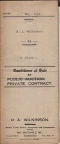 Bendigo Historical Society Inc.
Document - H.A. & S.R. WILKINSON COLLECTION: CONDITION OF SALE
Conditions of sale by private contract dated 12th May, 1932 between H.A. Wilkinson (seller) and S. Rigby (buyer) for land within the special settlement area situate Junortoun containing 17 acres, 1 rood, 27 perches being allotment 37F Parish of Wellsford, County of Bendigo described in Crown grant volume 4485 folio 896958, together with 4-roomed weatherboard dwelling and all sundry. Price 575 pounds.organization, business, h.a. & s.r wilkinson real estate -
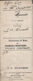 Bendigo Historical Society Inc.
Document - H.A. & S.R. WILKINSON COLLECTION: CONDITION OF SALE
Conditions of sale by private contract dated 22nd August 1935 between J.C. Symons (seller) and Mrs L.A. Runnalls for land situate corner Goyne Road and Epsom Road, Epsom, being Crown allotment 4 and 8 section 25 containing approx. 3 acres, 2 rood and 9 perches and occupied by Mr. Makeham as tenant, together with 4-roomed weatherboard dwelling and all sundry. Price 340 pounds.organization, business, h.a. & s.r wilkinson real estate -
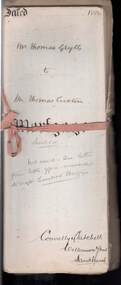 Bendigo Historical Society Inc.
Document - CONNELLY, TATCHELL, DUNLOP COLLECTION: LEASE HOLD MORTGAGE MR. THOMAS GRYLLS TO THOMAS LUXTON ESQ
a. Leasehold mortage documents Mr. Thomas Grylls to Thomas Luxton Esq. Registered 16th. November, 1888, No. 96127. Parish of Dingee, County of Bendigo, 224 acres 3 roods and 9 perches. Vols 256, Folio 51104, Vols 279, Folio 55715, Vols 307, Folio 61362, Vols 416, Folio 83186. Mortgage document, various letters, notes, calculations of costs pertaining to above transaction enclosed in file.cottage, miners, connelly, tatchell & dunlop, thomas grylls, thomas luxton, sharebroker, h. harrison, titles, sandhurst, dingee -
 Bendigo Historical Society Inc.
Document - LANDS OFFICE : SPECIAL LAND SALES IN SANDHURST 1861 TO 1864, 1861 - 1864
Document: light brown cover, hard cover journal. Contains details of crown lands surveyed and sold in the District of Sandhurst. Index and 217 pages. LH page: parish, town lands, suburban lands, country lands, total lands surveyed, date of survey. RH page: date of sale, by auction, by selection, price per acre, total amount, names of purchasers. On spine: '2' in red, ' sales Bendigo 1861 - 1864'Lands Officeplace, bendigo, land sales, bendigo, sandhurst, land sales, land surveyed -
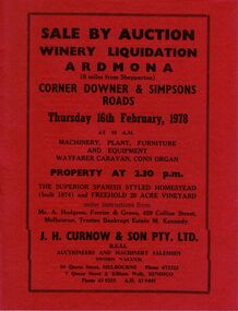 Bendigo Historical Society Inc.
Document - IAN DYETT COLLECTION: AUCTION CATALOGUE - WINERY LIQUIDATION - ARDMONA
Two red covered auction catalogue with black printing for a sale on 16th February 1978 for a Winery Liquidation, Ardmona, under instructions from Mr. A. Hodgson, Ferrier & Green, Trustee Bankrupt Estate M. Kennedy. For sale was a Spanish styled homestead (built 1974) and Freehold 20 acre vineyard. Also tools, wine making equipment, Water Right, machinery and furniture. J. H. Curnow & Son Pty. Ltd. Were the auctioneers.business, auctioneers, j h curnow & son pty ltd, ian dyett collection - auction catalogue - winery liquidation - ardmona, mr a hodgson ferrier & green, estate m kennedy, j h curnow & son pty ltd, f c dyett, i m dyett, bolton bros print