Showing 2558 items
matching aerials
-
 St Kilda Historical Society
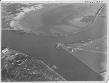
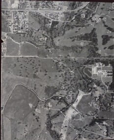
Photograph - Photo map, 22/01/1970
One of a series of photo-maps produced for the Department of Crown Lands and Survey (1857-1983). For correlation with a current map, and access to other historical photo maps of Victoria, see the Historic Photo-Maps Index published by the Department of Environment, Land, Water and Planning at https://services.land.vic.gov.au/DELWPmaps/historical-photomaps/Black and white aerial photographVic 2358 Department of Crown Lands and Survey Victoria,.© Melbourne 1970 Project Run 43E 22.1.70 5,100 ASL 206elwood, elsternwick, elsternwick park, 1970 -
 Stawell Historical Society Inc
Photograph - Slides, Ian McCann, Aerial View 1976, 1976 - 1984
Aerial Colour Photograph of Stawell -
 Rutherglen Historical Society
Map - Photocopy of an aerial photograph
Photocopy of an aerial photograph of Rutherglenaerial photographs, rutherglen -
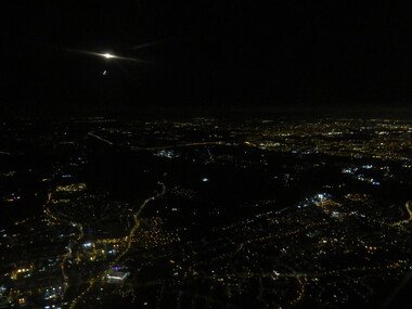 Ballarat Heritage Services
Photograph - Photograph - Colour, London by night aerial, 2017
Aerial photograph of London by night. london, night, england, aerial, lights -
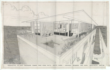 Robin Boyd Foundation
Drawing - Aerial Perspective, Domain Park, Sept 1960
Project: Domain Park from office of Grounds Romberg and Boyd. Perspective of Penthouse. The Domain Park flats (1959-62) were designed by Robin Boyd and were among the first high-rise blocks of ‘luxury’ flats constructed in post-war Melbourne. This exterior perspective highlights the unparalleled views available from the penthouse apartment.Aerial Perspective, Tracing Paperdomain park, robin boyd, ohm2022, ohm2022_14 -
 Port Fairy Historical Society Museum and Archives
Photograph - photograph-mounted, R.W.Golding, 1925
Flight taken in 1925 by Mr R.W.Golding Black and white aerial PhotographMartins's Point Moyne Riveraerial view, martin's point, moyne river, r.w.golding, flight -
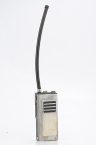
 Department of Energy, Environment and Climate Action
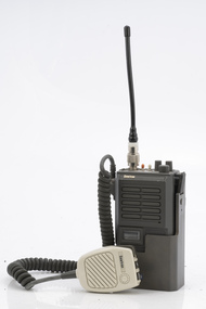
Philips portable radio HPFX
After the 1939 bushfires, the Forests Commission Victoria invested heavily in a radically new communications network. After suffering some inevitable delays due to the war, radio VL3AA switched into full operation in October 1945 proudly beaming out 200 watts across the State. But by today’s standards, the technology was primitive and the reception poor unless the user was on a high point somewhere. The radio signal was "line-of-sight" and bounced between fire towers and relay transmitters across the mountains back to the District offices. The advent of solid-state electronics in the 1960s replaced the more delicate valve sets which enabled greater use of vehicle mounted radios. The Commission continued to research, develop and build new radios at its many workshops around Victoria. The network was supported by a large team of skilled radio technicians. The more secure and versatile State Mobile Radio (SMR) digital trunk system came into operation in about 1995. Upgraded Tait Radios were purchased in 2014 after recommendations of the 2009 Bushfires Royal Commission. But it was the convergence of separate technologies such as 5G mobile phones, high-capacity and light-weight lithium batteries, Wi-Fi, the ever-expanding internet, cloud data storage, digital cameras, GPS, personal organisers and hundreds of supporting Apps into powerful smartphones and tablets which revolutionised bushfire communications from the mid-2000s. Portable radio with aerial and handsetbushfire, radios, forests commission victoria (fcv) -
 Department of Energy, Environment and Climate Action
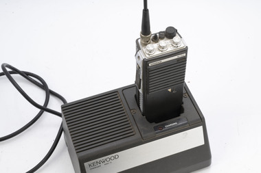
Kenwood Portable radio TK300
After the 1939 bushfires, the Forests Commission Victoria invested heavily in a radically new communications network. After suffering some inevitable delays due to the war, radio VL3AA switched into full operation in October 1945 proudly beaming out 200 watts across the State. But by today’s standards, the technology was primitive and the reception poor unless the user was on a high point somewhere. The radio signal was "line-of-sight" and bounced between fire towers and relay transmitters across the mountains back to the District offices. The advent of solid-state electronics in the 1960s replaced the more delicate valve sets which enabled greater use of vehicle mounted radios. The Commission continued to research, develop and build new radios at its many workshops around Victoria. The network was supported by a large team of skilled radio technicians. The more secure and versatile State Mobile Radio (SMR) digital trunk system came into operation in about 1995. Upgraded Tait Radios were purchased in 2014 after recommendations of the 2009 Bushfires Royal Commission. But it was the convergence of separate technologies such as 5G mobile phones, high-capacity and light-weight lithium batteries, Wi-Fi, the ever-expanding internet, cloud data storage, digital cameras, GPS, personal organisers and hundreds of supporting Apps into powerful smartphones and tablets which revolutionised bushfire communications from the mid-2000s. Portable radio with aerial and chargerbushfire, radios, forests commission victoria (fcv) -
 Department of Energy, Environment and Climate Action
Sawtron portable radio
After the 1939 bushfires, the Forests Commission Victoria invested heavily in a radically new communications network. After suffering some inevitable delays due to the war, radio VL3AA switched into full operation in October 1945 proudly beaming out 200 watts across the State. But by today’s standards, the technology was primitive and the reception poor unless the user was on a high point somewhere. The radio signal was "line-of-sight" and bounced between fire towers and relay transmitters across the mountains back to the District offices. The advent of solid-state electronics in the 1960s replaced the more delicate valve sets which enabled greater use of vehicle mounted radios. The Commission continued to research, develop and build new radios at its many workshops around Victoria. The network was supported by a large team of skilled radio technicians. The more secure and versatile State Mobile Radio (SMR) digital trunk system came into operation in about 1995. Upgraded Tait Radios were purchased in 2014 after recommendations of the 2009 Bushfires Royal Commission. But it was the convergence of separate technologies such as 5G mobile phones, high-capacity and light-weight lithium batteries, Wi-Fi, the ever-expanding internet, cloud data storage, digital cameras, GPS, personal organisers and hundreds of supporting Apps into powerful smartphones and tablets which revolutionised bushfire communications from the mid-2000s. Portable radio with aerial and handsetKG109 - 40DO 5KWbushfire, radios, forests commission victoria (fcv) -
 Department of Energy, Environment and Climate Action
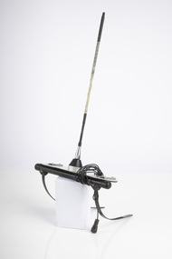
Portable radio aerial
After the 1939 bushfires, the Forests Commission Victoria invested heavily in a radically new communications network. After suffering some inevitable delays due to the war, radio VL3AA switched into full operation in October 1945 proudly beaming out 200 watts across the State. But by today’s standards, the technology was primitive and the reception poor unless the user was on a high point somewhere. The radio signal was "line-of-sight" and bounced between fire towers and relay transmitters across the mountains back to the District offices. The advent of solid-state electronics in the 1960s replaced the more delicate valve sets which enabled greater use of vehicle mounted radios. The Commission continued to research, develop and build new radios at its many workshops around Victoria. The network was supported by a large team of skilled radio technicians. The more secure and versatile State Mobile Radio (SMR) digital trunk system came into operation in about 1995. Upgraded Tait Radios were purchased in 2014 after recommendations of the 2009 Bushfires Royal Commission. But it was the convergence of separate technologies such as 5G mobile phones, high-capacity and light-weight lithium batteries, Wi-Fi, the ever-expanding internet, cloud data storage, digital cameras, GPS, personal organisers and hundreds of supporting Apps into powerful smartphones and tablets which revolutionised bushfire communications from the mid-2000s. Radio Aerial for use with aircraftbushfire, radios, forests commission victoria (fcv) -
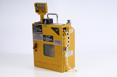 Department of Energy, Environment and Climate Action
Raindance Aerial Incendiary Machine R2
Alan McArthur from the CSIRO began his experimental burning program in the late 1950s near Canberra and published his landmark paper in 1962, “Controlled burning in eucalypt forests”. Leaflet No. 80, as it was known, proved a turning point for forest and fire managers across Australia. It led to the McArthur Forest Fire Danger Meter (FFDM) which first appeared in operational use in 1967 as the Mk 4. The CSIRO had developed its semi-automatic aerial incendiary machine dropping small capsules, with the first trial from a fixed-wing Cessna 337 at Manjimup in December 1965. Many technological and safety improvements followed including the Raindance machineAerial Incendiary Machine developed in Western Australia Rather than "ping pong balls" it uses a belt of incendiary "caplets" which are injected inside the machine before being ejected Raindance Systems R2forests commission victoria (fcv), planned burning, bushfire aviation, bushfire -
 Glenelg Shire Council Cultural Collection
Photograph - Photograph - aerial view of Portland, 1988
Census Project No. 1995. Portland Dec. 1988.Aerial view of the "City of Portland" and surrounding rural area to a scale of 1:10,000 Aerial Photomosaic of Portland Bay, 1988Front: (no inscriptions) Back: (no inscriptions)aerial photography, central portland, portland harbour -
 Bendigo Historical Society Inc.
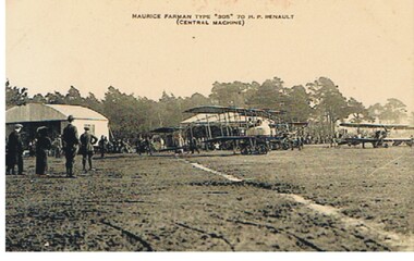
Postcard - BASIL WATSON COLLECTION: BIPLANES, MAURICE FARMAN TYPE 305
Postcard: image of biplanes, sheds in background, trees behind, many men standing viewing the planes. Written on top ' Maurice Farman Type '305' 70 h.p. Renault ( Central Machine )John Drew, Aldershot & Farnborough, ' our aerial defence' seriesaviation, civilian, maurice farman type 305, basil watson -
 Bendigo Historical Society Inc.
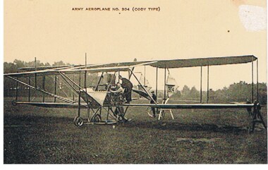
Postcard - BASIL WATSON COLLECTION: ARMY AEROPLANE CODY TYPE
Postcard: sepia coloured card - biplane with three men standing alongside and on plane. Written on top of photo' army aeroplane No. 304 ( Cody type )'John Drew, Aldershot & Farnborough. Our aerial defence series.aviation, military, army aeroplane, basil watson, biplane -
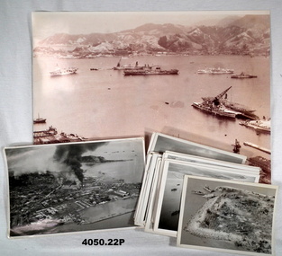 Bendigo Military Museum
Photograph - PHOTOGRAPHS, KOREA, 1950-1953
The photos are a collection held by T. J. IRELAND C/K853677 P.O. STOKER MECHANIC RN while serving on HMS TRIUMPH, Korea 1950-53. Many are of the landings at INCHON, Sept. 1950. .1) Kure Harbour, Japan 1950. Ships assembling for the landings at INCHON, Korea. Ships across the top, left to right: HMAS SYDNEY, Fleet Oiler, VSS ANTIETAM, Hospital Ship & Japanese Coaster. In the foreground on the right, HMS BELFAST, HMS TRIUMPH, HMS CONSORT. On rear most photos are written on in blue pen. .2) INCHON landings Walmi-Do in background and landing barges - could be one I was driving. .3) Island - Walmi-Do - US landing craft. .4) INCHON landings. .5) US landing craft. .6) INCHON oil tanks and military targets on fire. .7) Grounded coaster after an air attack. .8) Two North Korean supply ships hit by rockets. .9) Korean supply vessels camouflaged. .10) Rocket attack on Korean supply vessel. .11) Sunken coaster that was carrying arms and food. .12) Sunken coaster in harbour. .13) & .14) North Korean armour taken from an observation flight. .15) & .16) Chinese tanks and armour. .17) HMS BELFAST, Fleet Oiler, HMAS WARRAMUNGA .18) Targets from rocket attacks. .19), .20) & .21) "Seafires" coming to land on HMS TRIUMPH. .22) Rearming cannon and rockets on a "Seafire'. Photos not written on, information was supplied by T.J. IRELAND. The "Seafire" was a naval adaption of the Supermarine Spitfire for carrier use..1) Photo, sepia tone, aerial view over a harbour with warships, bomb damage foreground, hills and buildings in the distance. .2) Photo, black & white, aerial view of harbour, city with several fires from shelling. .3) Photo, black & white, aerial view of island with landing craft. .4) Photo, black & white, aerial view over ships and harbour. .5) Photo, black & white, aerial view over four landing craft. .6) Photo, black & white, aerial view over city and fires. .7) Photo, black & white, aerial view over islands, boat .... small island. .8) Photo, black & white, aerial view over harbour with two boats on fire. .9) Photo, black & white, aerial view over structures covered. .10) Photo, black & white, aerial view over ship being attacked. .11) Photo, black & white, aerial view over harbour with sunken ship. .12) Photo, black & white, aerial view showing harbour, fire and sunken ship. .13) Photo, black & white, aerial view, five tanks along a road. .14) Photo, black & white, aerial view, same area as .13) showing a wider area. .15) Photo, black & white, aerial view showing tanks and armour. .16) Photo, black & white, aerial view road with armour, vehicles, people and smoke in distance. .17) Photo, black & white, aerial view showing three ships together. .18) Photo, black & white, aerial view showing a road control with targets either side on fire. .19) Photo, black & white, aerial view with aeroplane coming onto the deck of a carrier. .20) Photo, black & white, aerial view of a fighter plane. .21) Photo, black & white, on deck of a carrier. .22) Photo, black & white, rearming a plane with ammunition on carrier deck. Photos are various sizes.photos, korea, rn, inchon -
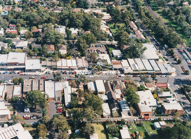 Eltham District Historical Society Inc
Photograph - Aerial Photograph, Montmorency Shopping Village, Were Street, Montmorency, 1994
Aerial photographs of Montmorency Shopping Village with a central focus on the former Montmorency Theatre and Bingo Hall situated at 41-43 Werte Street. In 1993 Eltham Shire Council issued a permit to Michael Muzur, Terry Lant and Andrew McMillan to redevelop the former Montmorency Theatre/Bingo Hall at 41-43 Were Street as an alcohol-free youth entertainment centre. Ron McCormack, retired former JP on behalf of 41 Joint Appellants consisting of local residents and traders successfully lobbied the community and won an Appeal to have the permit cancelled as unsuitable development. The Administrative Appeal Tribunal found that the proposed development came withing the Eltham Planning Scheme definition of an 'amusement parlour' and that the playing of pool an amusement machines would be the focus of the centre and unlikely to attract older age groups. The tribunal was not satisfied the applicants had sufficient knowledge or where with all required for the successful running of this type of operation. With respect to the objectors, the Tribunal did not accept that a responsibly managed and attractive amusement parlour could not coexist near the adjoining residential area and without detriment to the commercial centre. At a Council meeting on June 7, 1994 councillors requested a report outlining criteria to be used to assess planning applications for youth entertainment venues given the Tribunal's view that a poorly managed facility in a small neighbourhood shopping centre, particularly in such close proximity to a residential area would not only have the potential to increase perceived youth problems, but could jeopardise the prospects of future proposals. Ron McCormack moved to Montmorency from Coburg in the early 1980s and from then sat on the bench at Eltham Courthouse when Police requested assistance out of hours, until the eventuial closure of the Courthouse. montmorency theatre, montmorency bingo hall, 41-43 were street, youth entertainment centre, eltham shire council, planning permit, administrative appeals tribunal, ron f mccormack, aerial photograph -
 Falls Creek Historical Society
Postcard - Views of Falls Creek 1959
postcards feature images taken by Frederick Charles Griffith. “Fred” Griffith was born in Albury, NSW on 2 March 1910. Educated in Albury and Geelong Grammar. Beginning in 1927 he spent many years working first as a jackeroo and on a range of prominent pastoral and merino stud properties in NSW and Queensland. In 1935 he repurchased his former family property “Toonallook", Bowna, NSW and developed it to be the largest Romney Marsh stud in the world, exporting rams to Argentina. He introduced many innovative practices on his property including rabbit control measures and aerial crop dusting. He was an active member of the Albury Show Society and in 1949 established the Albury Sheep Show. Fred was also the Albury representative on the Graziers’ Association Council for over 30 years. He became a life member of both the Albury and Commercial Clubs. Fred’s greatest hobby was snow skiing. His first visit to the snow was to Kosciusko in 1919. The Albury Ski Club was formed in 1935 and Fred was an inaugural member. In 1949 they were granted a site at Falls Creek to build their own lodge. Fred guaranteed the Club for finance from the Bank of NSW. The first portion of the prefabricated building was constructed in Albury. It was transported to Falls Creek on the back of Fred’s truck and erected in one day. This was the bathroom section and the rest was completed in 1950. The original lodge was burned down in 1952 and a new one built the following year. In 1955, Fred also built the Bowna Lodge for his family in partnership with David Fairbairn. He became head of the North Eastern District Skiing Association (N.E.D.S.A.) and successfully applied to run the Australian Ski Championships. Fred also inaugurated children’s races at Falls Creek and ran them for about 20 years. He also formed the company “Falls Creek Ski Tows”. In 1956 Fred along with a group of key people selected the site for Thredbo Village. Fred and his brother sold Toonallook in sections between 1951 and 1974. He moved to Albury and set up as a landscape gardener and fencing contractor. After a serious work accident, Fred retired in 1985 and moved to Rosebud, Victoria where he died on 19 August 1992.These postcards document how Falls Creek was portrayed to the wider community.A set of postcards showing aerial views of Falls Creek as well as groups of skiers on the slopes, On Back of each card: POSTCARD CORRESPONDENCE / ADDRESS ONLY In a square for stamp Placement - KODAKfred griffith, albury ski club, falls creek, bowna ski club -
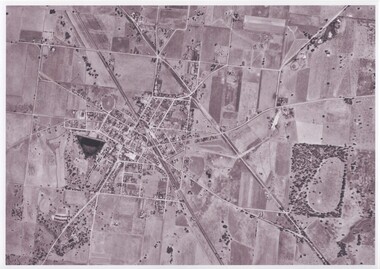
 Whitehorse Historical Society Inc.
Map, Campbell's Croft, c1970
Enlarged aerial photograph of the area around Campbell's Croft Reserve. State aerial Survey, Melbourne, 1970 project. Run 37Enlarged aerial photograph of the area around Campbell's Croft Reserve. State aerial Survey, Melbourne, 1970 project. Run 37Enlarged aerial photograph of the area around Campbell's Croft Reserve. State aerial Survey, Melbourne, 1970 project. Run 37campbells croft, boronia road, vermont, madonna court, vermont, aerial photographs -
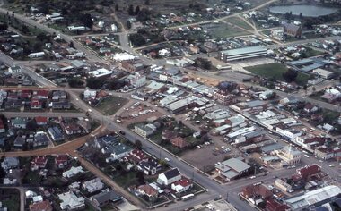
 Kew Historical Society Inc
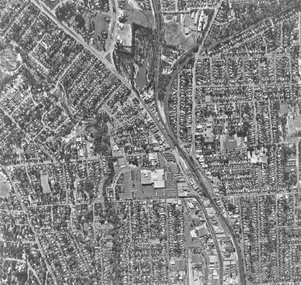
Photograph - Kew Junction, Herald & Weekly Times, 1962
This is an aerial oblique image looking north. It shows Kew Junction before construction of VicRoads (Country Roads Board), Murphy's (Leo's) supermarket, and office towers. It also shows a building on the land now known as the Raoul Wallenberg Reserve, the Kew Municipal Offices in Walpole Street, and St Paul's School for the Blind in Fernhurst Grove, and Kew Bowling Club in Wellington Street.An aerial photograph of Kew Junction, showing the intersection of High Street South, Studley Park Road, Princess Street, High Street and Denmark Street. A number of buildings, now demolished can be identified in the photo, including Jellis’ Bakeries on the corner of Princess Street and Studley Park Road." Annotation on reverse: "Kew Historical Society from Mr L. H. Chinner".kew junction, aerial photograph (kew), oblique aerial, st paul's school for the blind, kew municipal offices, high street kew, studley park road, kew war memorial, kew post office, kew police station, kew court house, high street south, kew, wellington street kew, denmark street kew -
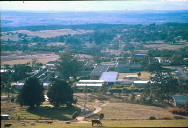 Federation University Historical Collection
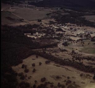
Photograph, Aerial View of Mount Helen Campus, 1985
Aerial views of Mount Helen Campusmount helen campus, aerial -
Federation University Historical Collection
Photograph, Aerial View of the Mount Helen Campus, 1983
Aerial view of the Mount Helen Campusmount helen campus, aerial -
 Greensborough Historical Society
Aerial Photograph, Banyule Road / Lower Plenty Road, 1972c
Viewbank, Rosanna and Lower Plenty area, showing Lower Plenty Road and Banyule RoadAerial survey photograph, black and whiteviewbank -
Glenelg Shire Council Cultural Collection
Photograph - Photograph - aerial view of Borthwicks, n.d
Glenelg Shire Council RecordsAerial view of Borthwick's factory and fields.Front: (no inscriptions) Back: (no inscriptions)thomas borthwick and sons, abattoir, portland -
 Ringwood and District Historical Society
Photograph, Aerial photograph of Ringwood - 1972
Black and white aerial photograph of Ringwood.Written on backing sheet, "Ringwood 1972". -
 Federation University Historical Collection
Photograph - Colour, Ballarat College of Advanced Education, Mt Helen Campus, late 1980s
Aerial photo of Mt Helen Campus -
 Stawell Historical Society Inc
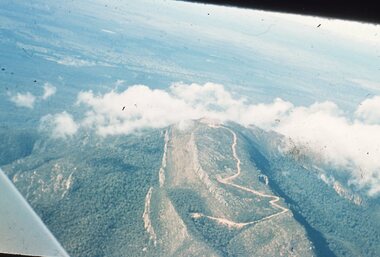
Slide, Ian McCann, Aerial View of the Grampians, 1960's
Aerial View of the Grampians though cloudsgrampians -
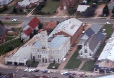 Stawell Historical Society Inc
Slide, Ian McCann, Aerial View of Town Hall
Aerial View of Town and nearby buildingsbuildings, town hall -
 Ballarat Heritage Services
Aerial digital photograph, L.J. Gervasoni, Mouth of the Yarra River and Westgate on approach to Melbourne's Tullamarine Airport, 2016
hoto taken from flight in to Melbourne International airport.Digital aerial image of Melbourne, Victoria.aerial, landscape, cityscape, mouth, yarra river, west gate bridge, aerial photograph -
University of Melbourne, Burnley Campus Archives
Plan - Plan, aerial photograph, Works Plan Scale 1:2000 [Aerial photograph of quarry]
In pencil on back of photograph: Lilydale Quarry Grid & a photolilydale, quarry -
 Department of Energy, Environment and Climate Action
Motorola portable radio
After the 1939 bushfires, the Forests Commission Victoria invested heavily in a radically new communications network. After suffering some inevitable delays due to the war, radio VL3AA switched into full operation in October 1945 proudly beaming out 200 watts across the State. But by today’s standards, the technology was primitive and the reception poor unless the user was on a high point somewhere. The radio signal was "line-of-sight" and bounced between fire towers and relay transmitters across the mountains back to the District offices. The advent of solid-state electronics in the 1960s replaced the more delicate valve sets which enabled greater use of vehicle mounted radios. The Commission continued to research, develop and build new radios at its many workshops around Victoria. The network was supported by a large team of skilled radio technicians. The more secure and versatile State Mobile Radio (SMR) digital trunk system came into operation in about 1995. Upgraded Tait Radios were purchased in 2014 after recommendations of the 2009 Bushfires Royal Commission. But it was the convergence of separate technologies such as 5G mobile phones, high-capacity and light-weight lithium batteries, Wi-Fi, the ever-expanding internet, cloud data storage, digital cameras, GPS, personal organisers and hundreds of supporting Apps into powerful smartphones and tablets which revolutionised bushfire communications from the mid-2000s. Portable radio with aerial and charging portMX 360bushfire, radios, forests commission victoria (fcv)