Showing 325 items
matching air navigation
-
 Moorabbin Air Museum
Document (Item) - ARINC - GNSS Navigation And Landing Unit (GNLU)
-
Moorabbin Air Museum
Manual - Overall Design Specification No. H.S.D. - W/107 to meet RAAF Air Staff Requirement No. NAV/54 for a Synthetic Navigation Trainer Reference 564/3/338, Hawker Siddle Dynamics Limited
-
Moorabbin Air Museum
Booklet - Carousel Inertial Navigation System Line Mechanics Guide, Delco Electronics
-
Moorabbin Air Museum
Manual (Item) - Aeronautics - Vol 2 Instruments & Accessories AND Vol 3 Navigation, Inspection and Tests
-
Moorabbin Air Museum
Book (Item) - Navigation And Meteorology
By D.Hay Surgeoner -
 Moorabbin Air Museum
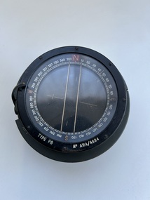
Instrument (Item) - Compass Navigational Type P8 Reference G6A/0726. ( 2 Units), Compass Navigational Type P8 Reference G6A/0726
-
 Moorabbin Air Museum
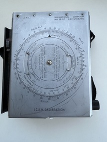
Equipment (Item) - Navigational Computor MK III D Ref. No. 6B/180
-
Moorabbin Air Museum
Manual - Private Pilots Licence Courses, Private Pilot Course Navigation and Flight Planning
Study guide of navigation & flight planning for private pilot studentsSpiral bound manualnon-fictionStudy guide of navigation & flight planning for private pilot studentsaircraft navigation -
Moorabbin Air Museum
Manual - Basics of Inertial Navigation, Fundamentals of Inertial Navigation
Non fiction. Decription of the fundamental of inertial navigationSpiral bound manual Non fiction. Decription of the fundamental of inertial navigation basics of inertial navigation -
Moorabbin Air Museum
Manual - Basics of Inertial Navigation, An Introduction to Inertial Navigation
Non fiction, Reproductions from script and color slides of an audio visual presentation on the basics of inertial navigationSpiral bound manualNon fiction, Reproductions from script and color slides of an audio visual presentation on the basics of inertial navigation basics of inertial navigation -
Moorabbin Air Museum
Book - Aviation Ground School Training - Cadet System, The Nes Cadet System of Ground School Training
Text for ground school cadets on navigation, meteorology, radio beam flying & orientation , circa 1930sManual style booknon-fictionText for ground school cadets on navigation, meteorology, radio beam flying & orientation , circa 1930snavigation, meterorology, radio beam fl, orientation circa 1930s -
Moorabbin Air Museum
Map (Item) - Maps of Northern Australia and New Guinea, AUS RNC 5 and 6 radio navigation maps
-
Moorabbin Air Museum
Map - RAAF Navigational Maps
Historical Details: . Description: Official Wartime Maps NewGuinea, New Britain etc AAP Date: 1940-45 Author: RAAF Amended to AL Publisher: RAAF Pages: 15 Maps Binding: Content/Keywords. Level of Importance: -
 Bendigo Military Museum
Photograph - 4th Field Survey Squadron – Operation ARIGHT 93, Queensland, 1993
This is a set of 42 photographs taken during 4th Field Survey Squadron’s deployment on Operation ARIGHT 93 in North Queensland from the 30th of August to the 8th of October 1993. The Survey Field Completion area of operations was Weipa near the top end of the Cape York Peninsula. Survey parties conducted field checking of topographic maps covering Bamaga, Heathlands, Weipa, Lockhart River and Strathgordon in Perentie 110 Series Survey variant FFR Land Rovers. Hand-held Trimble and Magellan GPS receivers were used to assist with navigation and to position remote isolated features. Three Bell Kiowa LOH helicopters provided by 162 Recce Sqn supported field checking operations. Supplementary and Vital Asset Protection photography was taken by air camera operators in AAAvn Nomad aircraft from 173 Survl Sqn fitted with an RC10 aerial camera.This is a set of 42 photographs taken in 1993 durin8g 4th Field Survey Squadron’s deployment on Operation ARIGHT in North Queensland. The colour photographs are on 35mm negative film and are part of the Army Survey Regiment’s Collection. The photographs were scanned at 96 dpi. .1) - Photo, colour, 1993. Survey party in Perentie 110 Series Land Rover navigates through Cape York Peninsula sand hills. .2) - Photo, colour, 1993. Cape York Peninsula sand hills. .3) - Photo, colour, 1993. Cape York Peninsula Island. .4) - Photo, colour, 1993. Survey party in Perentie 110 Series Land Rover enters a Cape York Peninsula beach. .5) - Photo, colour, 1993. SPR Kim Baker takes a break on a Cape York Peninsula beach. .6) - Photo, colour, 1993. L to R: MAJ Andy Cordova (USA Exchange) from the Army Survey Regiment and unidentified civilians. .7) to .14) - Photo, colour, 1993. Cape York Peninsula topography. .15) - Photo, colour, 1993. Unidentified surveyor in Bell Kiowa LOH helicopter. .16) - Photo, colour, 1993. Bell Kiowa LOH helicopter circles base camp. .17) to .18) - Photo, colour, 1993. Cape York Peninsula topography. .19) - Photo, colour, 1993. Vehicle convoy taking a break. L to R: LT John Bath (Detachment OC), unidentified (x2), SPR Chris Pearse. .20) - Photo, colour, 1993. Vehicle convoy taking a break. .21) - Photo, colour, 1993. Vehicle convoy ready to go. SPR Chris Pearse. .22) - Photo, colour, 1993. Vehicle convoy on the move. .23) - Photo, colour, 1993. Cape York Peninsula topography. .24) - Photo, colour, 1993. Unidentified personnel. .25) - Photo, colour, 1993. SGT Neale ‘Tex’ Houston. .26) - Photo, colour, 1993. Ground below a Bell Kiowa LOH helicopter .27) - Photo, colour, 1993. L to R: SPR Mark Sinderberry and CPL Stuart Adrain in a Bell Kiowa LOH helicopter. .28) & .29) - Photo, colour, 1993. Ground below a Bell Kiowa LOH helicopter. .30) - Photo, colour, 1993. Base camp viewed from a Bell Kiowa LOH helicopter. .31) - Photo, colour, 1993. Cape York Peninsula topography in recovery after burn-off. .32) & .33) - Photo, colour, 1993. SPR Kim Baker contemplates crossing this bridge in his Land Rover. .34) - Photo, colour, 1993. SPR Kim Baker takes a break next to a billabong. .35) - Photo, colour, 1993. Survey party in Perentie 110 Series Land Rover crosses a creek. .36) - Photo, colour, 1993. Cape York Peninsula bush fire in distance. .37) - Photo, colour, 1993. Survey party in Perentie 110 Series Land Rover traverses a sand hill. .38) - Photo, colour, 1993. SPR Kim Baker. .39) - Photo, colour, 1993. Cape York Peninsula bush fire. .40) - Photo, colour, 1993. Cape York Peninsula topography. .41) & .42) - Photo, colour, 1993. Cape York Peninsula sand hills..1P to .42P – There are no personnel identified. ‘1993 OP ARIGHT’ annotated on negative sleeve.royal australian survey corps, rasvy, 4 fd svy sqn, op aright 93 -
 Moorabbin Air Museum
Document (Item) - (SP) AAP 7832.022-4-3 TACAN Navigational Set AN/ARN-52 (V) Amendment List 1
Defence Instruction (Air Force) AAP 7832.002-4-3 -
Moorabbin Air Museum
Magazine - The BASI Journal - Bureau of Air Safety Investigation, The Basi Journal 10
... yaw, drugs, air safety & the media, air navigation laws ...Articles on heicopter yaw, drugs, air safety & the media, air navigation laws, aircraft accidents smoke & dust haze. Circa Dcember 1991MagazineArticles on heicopter yaw, drugs, air safety & the media, air navigation laws, aircraft accidents smoke & dust haze. Circa Dcember 1991 -
 Flagstaff Hill Maritime Museum and Village
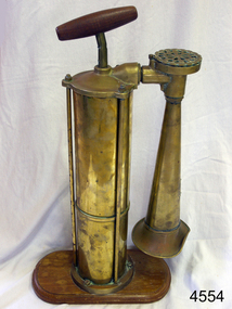
Equipment - Foghorn, 20th century
A marine foghorn gives an audible navigational signal to warn vessels of dangers, hazards and the presence of other vessels in fog conditions. The foghorn signal is a series of long and short sounds with short or long pauses between them. These common signals conform to a code called the International Regulations for Preventing Collisions at Sea and provide such information as whether the vessel is under sail or motor, large or small, aground or at anchor. The designs of foghorns vary but they all use a column of air to make a loud sound. Some use vibrating plates or metal reeds, others force air through holes in a revolving cylinder or disc, sounding like a siren, and some use a clockwork mechanism to open the valves that let the air into the horn. They are usually built to meet particular specifications e.g. U.S.C.G. (US Coast Guard). This Tyfon plunger foghorn has a horizontal handle attached to a vertical rod that moves up and down inside a cylinder. When the handle is plunged down, in a similar way to a bicycle pump, the air is forced out of the bottom of the cylinder into a pipe with a bell-shaped horn on the end, making a loud, low sound. The wider base of the cylinder helps to keep it stable. The original type Tyfon foghorns were manufactured in about 1910 by Kochums Mechanical Workshop (Kockums Mechanical Werkstad, Ltd.), Malmo, Sweden. The company was established in 1840, became a Limited company in 1866, and established a shipyard at the Port of Malmo, Sweden, in 1870. The civilian ship production in Malmo ceased in 1987. As well as building ships the company built large industrial and agricultural machinery and maritime goods.this replica foghorn represents the design of a Swedish, Tyfon model 1910. It is an example of the type of safety equipment used on marine vessels to signal other vessels and signal to land. Replica foghorn; portable marine, plunger operation. It has a brass cylinder and adjustable brass horn. The plunger handle and base are wooden. Inscriptions are on the plaque on the horn and moulded into the air intake. Facsimile of a Kockums of Malmo, Sweden, Tyfon model 1910 Fog Horn.Impressed into the attached plaque "KOCKUMS MLK. VERKSTAD / MALMO SWEDEN" and "TRADE TYFON MARK" Also added to the plaque individually "288938" Molded around the circumference of the air intake "TYFON PATENT"flagstaff hill, warrnambool, shipwrecked coast, flagstaff hill maritime museum, maritime museum, shipwreck coast, flagstaff hill maritime village, great ocean road, foghorn, fog horn, tyfon foghorn, kockums mlk verkstad, malmo sweden, replica, warning signal, safety equipment, ship's equipment -
Moorabbin Air Museum
Manual - RAAF Air reservist manuals, Royal Austrralian Air Force Manual for Air Crew Reservists
Overview of flight, aircraft systems, navigation, etc. for RAAF Reservists circa 1940Manual in book formOverview of flight, aircraft systems, navigation, etc. for RAAF Reservists circa 1940aircraft systems, navigtion, principles of flight -
 Moorabbin Air Museum
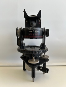
Instrument (item) - Astro Compass A.M (Air Ministry) MKII 6.A/1174
A.M Astro Compass MKII 6.A/1174 2 x -
Moorabbin Air Museum
Book - Aerial navigation, The Complete Air Navigator
... The Complete Air Navigator Book Aerial navigation ...Overview of the methods of aerial navigation, circa 1954non-fictionOverview of the methods of aerial navigation, circa 1954background, observational methods, general application -
 Wangaratta RSL Sub Branch
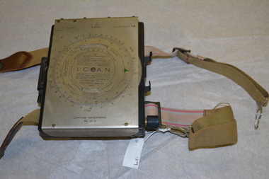
Instrument - Aircraft Navigation Computer
The navigational computer was a circular slide rule used for calculating height and air speed corrections when flying an aircraft. The front cover lifts to reveal a further calculator used to solve vector triangles and plot course alterations. The device was intended to be strapped to a pilot's leg. The instrument was made by White and Gillespie (Melbourne) Pty Ltd c 1940 for the RAAF and used during WW2.Black metal box with silver metal flap top cover affixed with rotating circular rule . Two adjustable belts are affixed to the base of black box. A small spiral bound note book is contained beneath the flap top. RAAF Computer Navigational system MK. III. D. Serial No WG 2833navigation, raaf, computer, aircraft, ww2, 1940 -
Moorabbin Air Museum
Journal - The Journal of Navigation, The Journal of Navigation Volume 64 Number 4 October 2011
... The Journal of Navigation Air traffic control sepaaration ...Articles on aviation & non aviation navigation matters, circa 2011non-fictionArticles on aviation & non aviation navigation matters, circa 2011air traffic control sepaaration -
Moorabbin Air Museum
Journal - The Journal of Navigation, The Journal of Navigation Volume 64 Number 3 July 2011
... The Journal of Navigation Air traffic control sepaaration ...Articles on aviation & non aviation related navigational matters, circa 2011non-fictionArticles on aviation & non aviation related navigational matters, circa 2011air traffic control sepaaration -
Moorabbin Air Museum
Book - Navigation, The Observer's Book on Dead Reckoning Navigation
Overview of all forms of dead reckoning navigation, circa 1940non-fictionOverview of all forms of dead reckoning navigation, circa 1940general remarks, position lines, air plotting, relative velocity, radius of action -
 Bendigo Military Museum
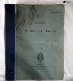
Manual - AIR MINISTRY INSTRUMENT MANUAL, British Air Ministry et al, 1937
... . Illustrated drawings, photos & navigational charts. Manual AIR ...Light blue hard cover book with Royal Coat of Arms at bottom, blue buckram binding & black print. Many pages. 11 sections on flight instruments & their use. Illustrated drawings, photos & navigational charts.Inside front cover: “A M Watkins 10”books - manuals/military/air force, british, instrument