Showing 9254 items
matching baily
-
 Lakes Entrance Historical Society
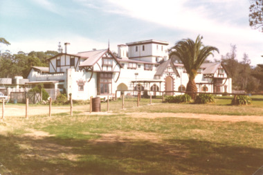
Photograph, M Holding, Whitehorse Inn Twofold Bay near Eden N.S.W, 1980 c
Colour photograph of Whitehorse Inn Twofold Bay near Eden N.S.W.hotels, accommodation, tourism, businesses -
 Port Melbourne Historical & Preservation Society
Film - Video Recording - Digital, Tim Allen, What Lies Beneath Port Phillip Bay, 27 Apr 2021
Digital video recording of PMHPS meeting held on 27 April 2021. We all know Port Phillip Bay – or we think we do. It’s the beach on our back doorstep and our outdoor playground. But the Bay’s natural history, and its underwater values are largely unknown to most. And the Port Phillip Bay of today is very changed from the Bay at the time of white settlement. So, what of its future? Tim ALLEN's talk delves beneath the Bay’s surface veneer, to uncover stories of lost sharks and oyster beds, scallop wars, sewerage, and shipping; a visual potted history of key points in time.port phillip bay, natural environment - beaches and foreshore, tim allen -
Port Melbourne Historical & Preservation Society
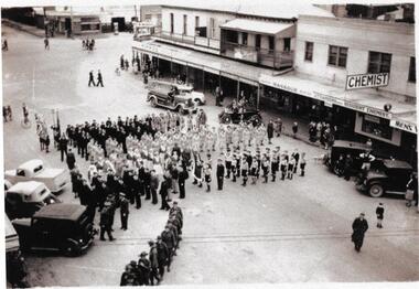
Photograph - Imperial Contingent marching in Bay Street, Port Melbourne, George Rose, Rose Stereograph Co
State Library acknowlegement required. View of Bay St Port Melbourne. Imperial contingent (Boer War) of mounted troops marching towards Bay in 1901. Spectators lining route, horse and cart on right.H93.302/1armed services - army, war, built environment - commercial, imperial contingent, boer war, mounted troops, george rose -
Port Melbourne Historical & Preservation Society
Film - DVD, "Bayside reflections", 2000
"Bayside reflections - Port Phillip Bay on film; Part 1. The Southern Portion." A history of Port Phillip Bay and it's beaches - as recorded on film. From the earliest years of the 20th Century to the beginnings of the 21st.transport - shipping, social activities, port phillip bay -
Port Melbourne Historical & Preservation Society
Film - DVD, "Bayside reflections"
"Bayside reflections - Port Phillip Bay on Film, Part 2. The top end". A history of Port Phillip bay and it's beaches - as recorded on film. From the earliest years of the 20th Century to the beginning of the 21st.transport - shipping, social activities, port phillip bay -
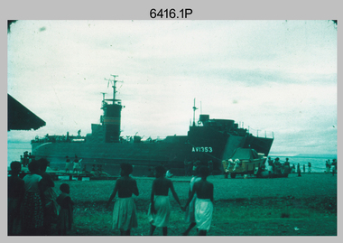 Bendigo Military Museum
Photograph - Royal Australian Survey Corps Surveyors in the Field – PNG, 1962
This is a set of four photographs of surveyors and support staff in the field undertaking duties in Dogera, Milne Bay Province and Kerema, Gulf Province of PNG in 1962. The surveyors were employed in the establishment of mapping and geodetic control. In this era surveyors used theodolites to observe horizontal and vertical angles and tellurometers to measure base line distances between survey stations. From 1957 helicopter transport of survey parties revolutionised transport in remote areas.This is a set of four photographs of surveyors and support staff in the field undertaking duties in PNG in 1962. The photographs were printed on photographic paper and are part of the Army Survey Regiment’s Collection. The photographs were scanned at 300 dpi. .1) - Photo, colour, 1962. Unloading survey operation stores from a Landing Ship Medium (LSM) at Dogera, Milne Bay Province, PNG. .2) & .3) - Photo, colour, 1962. Hired civilian helicopter Bell 47G-2 helicopters operating at at Dogera, Milne Bay Province, PNG. .4) - Photo, colour, 1962. Survey party at survey station located near Kerema, Gulf Province southern PNG. L to R: Dave Owens, Keith Broadbent, with local villagers in background..1P to .4P annotated on back – personnel names, the year and the location. royal australian survey corps, rasvy, army survey regiment, asr, army svy regt, fortuna, surveying -
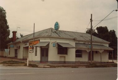 Bendigo Historical Society Inc.
Photograph - BENDIGO HOTEL COLLECTION: HIBERNIAN HOTEL, GOLDEN SQUARE
Colour photograph: Image shows Hibernian Hotel, Golden Square. Hotel situated on corner of High Street and Bay Street. Single storey white painted building, part verandah, some lace work. Corrugated iron roof. Hibernian Hotel written on Bay Street side of building. Single brick chimney, unpainted, Bay Street side.bendigo, hotel, hibernian hotel, golden square -
 Flagstaff Hill Maritime Museum and Village
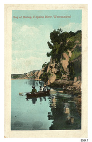
Postcard - Scenic - Warrnambool, Bay of Biscay, Hopkins River, Warrnambool, 1902-1910
The nine postcards in this set were donated together and date to the early 1900s. All but one postcard in this set shows images of Warrnambool, in the Western District of Victoria; the other has a London image. The postcards were all printed in Great Britain according to that country’s postal regulations. The fronts of all cards have titles printed in red. Most of the images on the cards are attributed to photographer Joseph Jordan and belong to the Jordan Series. The back of these cards has an outline for a postage stamp, a vertical dividing line and a heading on each side of the line to separate the Correspondence from the Address. Postcards or ‘correspondence cards’ appeared in Britain in 1894. They were plain cards with a space for the message on one side and an address on the other; regulations didn’t allow anything but the address to be written on the ‘address’ side. In 1902 the British regulations then allowed a picture to be printed on the front and the address on the back, so messages had to be written on the picture side. Soon, the regulations changed and the back was divided for a message and the address. Bay of Biscay, Hopkins River, Warrnambool – This same image was published in Table Talk on January 6th, 1910 and in The Age, on December 18, 1929, referred to a revival of fishing at the Bay of Biscay on the Hopkins River. These and similar articles showcased the Bay of Biscay as a popular boating and fishing location and well worth promoting to places outside of Warrnambool. Joseph Jordan - Joseph Jordan was born in 1841 in Leicester England. When he was 16 he joined the 7th Queen's Own Hussars and was sent to India at the outbreak of the mutiny. He took part in the relief of Lucknow and remained in India for eleven years. It was during this time that he became interested in photography. He was posted to New Zealand and later came to Victoria, becoming a sergeant major of the Mounted Rifles. In the mid-1880s he came to the Western district where he was responsible for establishing units of the Mounted Rifles in various country towns such as Dunkeld, Mortlake, Panmure, Bushfield, Koroit etc. He resigned from the army in 1889 and set up a professional photography studio in Liebig Street, Warrnambool. He became very well known in the Western District for family photographs, official photographs of local councillors and groups as well as views of local scenery. In 1891 he photographed the wrecked barque ‘Fiji’ at ‘Wrecks Beach’ near Princetown. His business was taken over by his son Arthur around 1917. Joseph was a keen rifle shot and in 1924 he donated the "Jordan Shield" as a prize to the Victorian Rifle Association. He was made a "Life Honorary Member" of the Warrnambool Returned Soldiers League and in 1933 he was recognised as being the oldest living soldier in Victoria. Joseph died in 1935 aged 95.The image of the figures in a row boat on the river suggests that the location was a popular place to visit. The choice of subject for this postcard indicates the popularity of Warrnambool's natural environment as a tourist attraction at a time when ships called coastal traders brought passengers and cargo to the Port of Warrnambool from ports along Victoria's southwest coast. Joseph Jordan is a significant figure in Warrnambool history as he helped to establish early units of the Mounted Rifles (G Company) in local towns during the late 1880's and later, photographed local scenes, groups and citizens of early Warrnambool.Postcard, one of nine, portrait orientation, coloured print within a rectangle border with an impressed line around the image and a title in red. The picture shows three figures wearing hats in a rowboat on the bank of a river beside cliffs. There is no correspondence written on the card. The back has inscriptions and outlines for a postage stamp. Jordan Series, printed in Great Britain.Front, in red: “Bay of Biscay, Hopkins River, Warrnambool” Back in green: “Jordan Series” “POST CARD” “PRINTED IN GREAT BRITAIN” “For correspondence” “The Address only to be written here”flagstaff hill maritime museum, flagstaff hill maritime village, flagstaff hill maritime museum and village, maritime museum, warrnambool, great ocean road, warrnambool and district, warrnambool scenes, local scenes, views of warrnambool, joseph jordan, jordan series, jordan photography, postcard, souvenir, correspondence, cameo postcard, bay of biscay, fishing, boating -
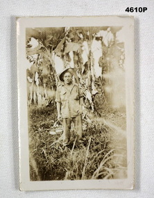 Bendigo Military Museum
Photograph - PHOTOGRAPH, PORTRAIT, C.1942 - 45
Doug Dean Collection, refer cat No 4575PPhotograph, sepia tone, shows a Australian soldier in casual uniform, shirt out, hat titled over, setting is in tropical environment.On the rear, “Doug Dean, 1942 - .... Milne Bay New Guinea”photographs, new guinea, milne bay -
 Glenelg Shire Council Cultural Collection
Photograph - Photograph - view of Portland Bay, n.d
Photographs taken by Esther Winifred Hall (nee Smallpage) - great grand-daughter of Stephen George Henty. Taken in 1934 Centenary celebrations in Portland.Black and white photograph showing a coastal scene with from left, foreshore with buildings, cars, people, pier and ocean.Back: "View of Portland Bay to E.W. Hall from Marg..."esther winifred hall, 1934, centenary, portland, photography -
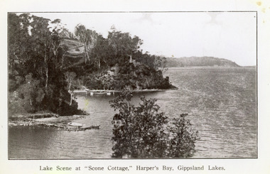 Lakes Entrance Historical Society
Photograph - Scone Cottage, 1920c
Copied from a postcardBlack and white photograph of Harpers Bight, Gippsland Lakes. It shows rustic jetty in foreground with boat moored, jetty below zigzag pathway to Cliff Crest Tea Rooms, a popular tourist venue, run by Mrs Westerson. Distant view of Jemmys Point. Lakes Entrance VictoriaLakes Scene at Scone Cottage, Harpers Bay, Gippsland Lakes tearoom, tourism, waterways -
Port Melbourne Historical & Preservation Society
Photograph - National Bank, Bay Street, Port Melbourne, Arthur Rowan, 1986
As a member of the Port Melbourne Historical and Preservation Society, donor Arthur ROWAN photographed a series of significant buildings in the Port and South Melbourne area over several years. A selection of nineteen of these was presented to the Port Melbourne Society in 1993.Small print mounted on white card, with mounted, typed caption: National Bank. 96 Bay Street corner Lt Bay Street. Allotment No 1864. Constructed 1874. First owner: National Bank of Australiabuilt environment - commercial, architecture, arthur rowan, leonard terry, national bank of australasia -
Port Melbourne Historical & Preservation Society
Photograph - Bay Street from the Sugar Works, Sandridge, c. 1872
One of a series assembled for the Melbourne Exhibition of 1873, original mount hanging in Engineering Department at Port Melbourne Town Hall at 19-9-1994. This set of prints belonged to Town Clerk Syd ANDERSON, then to his daughter-in-law Phyllis ANDERSON (donor). Accompanied by list of captions, both hand written and typed (the latter a partial listing).View of Bay Street from Sugar Works c 1872 showing Seisman's Royal Mail, Lambs and Royal Hotels, earliest Swallow & Ariell building and Rouse Street and Bay Street shops including carpenter's."P Anderson" on back, ink. On face of photo someone has in the 1990s added a numeral in ink. This has been retouched out on our digital copies.swallow & ariell ltd, sydney sims anderson, town clerks, bay street, rouse street, nott street, business and traders - hotels, business & traders - manufacturing -
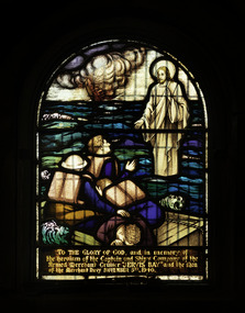 Mission to Seafarers Victoria
Artwork, other - Stained glass window, Brooks Robinson & Co, Jervis Bay, 1947
This window, in memory of the crew of the ship Jervis Bay, was unveiled on the 14 December 1947 by Mrs Johnson, wife of the Bishop of Ballarat. As mentioned on the plaque below the window, it was a gift of the Ballarat branch of the HLG and the Lucas Girls from Ballarat. E Lucas & Co was a textile company in Ballarat. The "Lucas girls" are known Ballarat-wide for their commitment to philanthropic work during the period of the Great War. From Bronwyn Hughes report: The window was designed and made by Brooks, Robinson & Co. Melbourne, from an old cartoon that was ‘touched up’. The size (24 1⁄2 x 17 1⁄4 inches) precluded the inclusion of any ornamental borders or other decorative features. The order was not received until 1947. Below this window is the plaque from the donors: the Ballarat Branch of the Harbour Lights Guild and Lucas Girls. On the same occasion the mallet, used to launch the ship Manunda was donated to the Mission. (AR1947) Unfortunately it is lost. Arched stained glass windows depicting Jesus floating on the surface of the sea holding out his right hand to seamen who on a raft, their ship sinking in the background.To the Glory of God and in loving memory of the heroism of the Captain and Ship’s Company, of the Armed Merchant Cruiser ‘Jervis Bay’ and the Men of the Merchant Navy November 5th 1940.altar, st peter chapel, flinders street, mission to seafarers, seamen's mission, mission to seamen, st peter, sailors, seamen, anchor, stained glass windows, win, memorial chapel, hope, jervis bay, crew, lucas girls, ballarat branch, hlg, jesus -
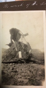 Phillip Island and District Historical Society Inc.
Photograph, The Wreck of the Speke, 1925-1926
Sepia photograph of two people standing on the wreck of the Speke at Kitty Miller Bay.The Wreck of the Spekephotographs, the speke, shipwrecks, kitty miller bay phillip island -
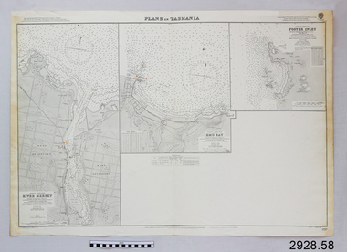 Flagstaff Hill Maritime Museum and Village
Document - Navigation Chart, Plans in Tasmania - Foster Inlet, River Mersey and Emu Bay
Navigation Chart - Plans in Tasmania - Foster Inlet, River Mersey and Emu Baywarrnambool, shipwrecked-coast, flagstaff-hill, flagstaff-hill-maritime-museum, maritime-museum, shipwreck-coast, flagstaff-hill-maritime-village, shipwrecked-artefact, river mersey, foster inlet, emu bay, navigation chart -
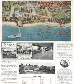 Phillip Island and District Historical Society Inc.
Brochure, Bayview Guest House, c 1920's
One of a collection of four items donated by Alice Robinson. Coloured brochure of Bay View Guesthouse with photos of the guesthouse and information about the Island..bayview guesthouse cowes, guesthouses cowes phillip island, alice robinson -
Glenelg Shire Council Cultural Collection
Slide - Agfacolour Slide - Henty Beach Portland Bay, P.G.W Whitelaw, 1960s
Taken by Mr P.G.W. (Wal) Whitelaw in the early to mid 1960'sAgfacolor slide of Henty Beach. Portland Bay lookings towards Fisherman's Breakwater. -
Glenelg Shire Council Cultural Collection
Photograph - Photograph - Main Breakwater construction, Portland, 13/07/1953
Port of Portland Authority ArchivesBack: Purple PHT Stamp Print No. 4/8 Neg No 160 Date Taken 13/7/57 Main Breakwater East Sideport of portland archives, harbour, portland, construction -
Glenelg Shire Council Cultural Collection
Photograph - Photograph - Main Breakwater construction, Portland, 30/06/1953
Port of Portland Authority ArchivesBack: Purple PHT Stamp - Print No 4/17 Neg. No 158 Date taken 30.6.53 Subject - Main Breakwater East Sideport of portland archives, main breakwater, construction, portland harbour, harbour development, lady bay -
Glenelg Shire Council Cultural Collection
Photograph - Photograph - Lady Bay reclamation, 1960-1966
Port of Portland Authority archivesFront: (no inscriptions) Back: (no inscriptions)port of portland archives, construction -
 Port Melbourne Historical & Preservation Society
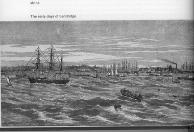
Drawing - Illustration, copy, Sandridge, R Jenny, R Jenny, 1800s
Lasercopy of engraving by R. Jenny 'Sandridge' - view from the bay, late 1800snatural environment, transport - shipping, r jenny - artist -
Port Melbourne Historical & Preservation Society
Photograph - Watercolour, Paddlesteamer, Weeroona, F K Fitreet, F K Fiterett, 1970s
Colour lasercopy of a watercolour by F.K. Fitrett of the Port Phillip Bay Paddlesteamer Weeroonatransport - shipping, ps weeroona -
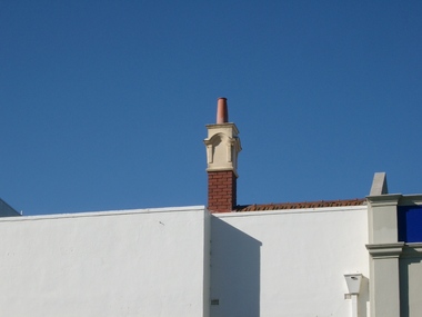 Port Melbourne Historical & Preservation Society
Photograph - Chimney, Flower Hotel, Bay Street, Port Melbourne, David Thompson, 12 Jun 2005
Colour photo of original art nouveau chimney of Flower Hotel in Bay St.built environment - commercial, flower hotel -
Port Melbourne Historical & Preservation Society
Photograph - 272 Bay Street, Port Melbourne, David Thompson, 1990s
J.E. Earl closed in the 1990s and was used as a video shop for several years before being rebuilt as shops and flats.One of five colour photographs of Port Melbourne streets: 272 Bay Streetbuilt environment - commercial, bay street -
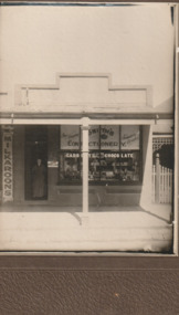 Port Melbourne Historical & Preservation Society
Photograph - Smith's Confectionery, Bay Street, Port Melbourne, 1920s
Original loaned to the Society for copying in May 2000 by Hilda Farnsworth a relative of the Smith's. A lasercopy was taken, then in December 2021 the original was donated by Anne Irado. photo of Smith's Confectionery in Bay Street c 1920. sEPIA IN BROWN MOUNTbusiness and traders - confectioners, smith's confectionery, bay street -
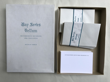 Robin Boyd Foundation
Functional object - Stationary
Personalised stationery for 290 Walsh St South Yarra 3141Bay Series Vellum Watermarked. Cards and mostly envelopes and Envelopes. deckle edgeswalsh st miscellaneous, robin boyd -
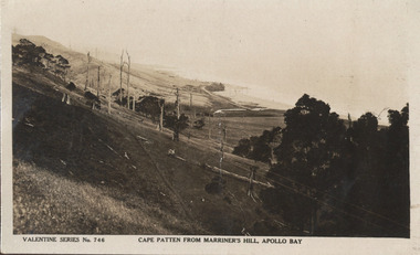 Ballarat Heritage Services
Postcard, Cape Patten From Marriner's Hill, Apollo Bay
Black and white photographic image of the beach at Apollo Bay from Marriner's Hill. apollo bay, cape patten, marriner's hill, beach, coastline -
 Old School House Museum
Photograph
Copy of an older photo, Bay St (Nepean Highway) Frankston Adults and children -
 Port Fairy Historical Society Museum and Archives
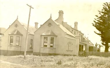
Photograph
The land for this building was granted to the Benevolent Society by James Atkinson in 1850. Tenders were being called for a new "Benevolent Asylum" in 1855, the foundation stone having been laid and by 1856 the first part of the Hospital was completed. These extensions probably carried out 1930's?????Black and white photograph of Right side of hospital new extension with bay windowshospital, institution, health service, extension, benevolent asylum, benevolent society