Showing 629 items
matching box william
-
 Whitehorse Historical Society Inc.
Pamphlet, Woodhouse Grove, c1980
Woodhouse Grove Methodist Chapel: letter written by Eliza Grace Aspinall to her sister-in-law, Kate Aspinall describing the wedding of her elder sister Emily and William Irwin at the Wesleyan Chapel at Woodhouse Grove in November 1881.woodhouse grove methodist church, aspinall family -
Whitehorse Historical Society Inc.
Article, Reunion all Toogood, 2002
Article describing the reunion of more than 100 members of the Toogood family in May 2002 at the grounds of Box Hill High School.Article describing the reunion of more than 100 members of the Toogood family in May 2002 at the grounds of Box Hill High School.Article describing the reunion of more than 100 members of the Toogood family in May 2002 at the grounds of Box Hill High School.toogood family, toogood, jim, tarry, amy, gray, elisabeth, james, joan, viola, joseph, georgy, william -
Whitehorse Historical Society Inc.
Article, Ideal for a Home Based Business, 1985
... Street Box Hill No. 28 Ellingworth William Robinson John Box Hill ...1880 Timber House for sale.1880 Timber House for sale. An early owner was William Ellingworth, whose son John established one of the areas first Real Estate Agencies. In 1956 John Robinson bought the property and taught Piano Accordion and Guitar for over 29 years at this house.1880 Timber House for sale. rose street, box hill, no. 28, ellingworth, william, robinson, john, box hill music centre -
 Whitehorse Historical Society Inc.
Document, Johann August Schwerkolt, 2013
Time line of the life of August Schwerkolt.Time line of the life of August Schwerkolt.Time line of the life of August Schwerkolt.schwerkolt august, richter paulina, schwerkolt emil august, schwerkolt louis, schwerkolt augustus, schwerkolt albert william, schwerkolt louis 2, schwerkolt paulina augusta, schwerkolt john william, schwerkolt richart reinhold, schwerkolt carl benno, schwerkolt johanna caroline, schwerkolt wilhelm ferdinand, schwerkolt johann theodor, schwerkolt bertha maria, schwerkolt maria elizabeth, kruse maria catherine wilhelmina, both franz, both johanna dorothea henriette, both wilhelmina, both francesca, schwarzman franz, emmi, vermont state school no. 1022, box hill cemetery, antonio, northcote victoria -
Whitehorse Historical Society Inc.
Article, Battle over Boer War monument, 2011
Historical society fights relocation of Box Hill Boer War obelisk.Historical society fights relocation of Box Hill Boer War obelisk.Historical society fights relocation of Box Hill Boer War obelisk.boer war 1899-1902, war memorials, box hill historical society, city of whitehorse, box hill returned servicemens league, orange, william, bowden, anthony peter, burra charter -
Whitehorse Historical Society Inc.
Document, Right of Burial, 1926
... Mitcham melbourne Certificate of Right of Burial for Mr William ...Box Hill general Cemetery.Box Hill general Cemetery. Certificate of Right of Burial for Mr William Cook, granted 27 Oct 1926 No. 7471 Grave No. 314Box Hill general Cemetery. cook, william -
 Whitehorse Historical Society Inc.
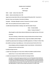
Article, Box Hill's oldest inhabitant, 1/06/1927 12:00:00 AM
An interview with Mr Sam CollierAn interview with Mr Sam Collier, then Box Hill's oldest resident and his memories of early days. Included are the naming of Box Hill and the departure of the first train from Melbourne to Sandridge.An interview with Mr Sam Collierellingworth, william, sutton, r, clisby, (school teacher), collier, samuel, box hill -
Whitehorse Historical Society Inc.
Document, William Cook of Box Hill, n.d
... William Cook of Box Hill...Notes on William Cook of Box Hill, died 1869 re allotments... District Board Cook Amy Notes on William Cook of Box Hill, died ...Notes on William Cook of Box Hill, died 1869 re allotments. Litigation with Nunawading District Board. He died before November 1869 without a will. Licence transferred to Amy Cook, 1870.Notes on William Cook of Box Hill, died 1869 re allotments. Litigation with Nunawading District Board. He died before November 1869 without a will. Licence transferred to Amy Cook, 1870.Notes on William Cook of Box Hill, died 1869 re allotments. Litigation with Nunawading District Board. He died before November 1869 without a will. Licence transferred to Amy Cook, 1870.cook, william, parish of nunawading, nunawading district board, cook, amy -
 Whitehorse Historical Society Inc.
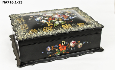
Functional object - Sewing Work Box
Owned by Jean Young - born Falkirk, Scotland, 1811. Believed to be listed in Falkirk Census in 1851. Married William Hill. Possibly sailed in 'Tempest'. Died at Dunolly, Victoria.Black paper mache sewing work box. Lid inlaid with abalone. General design has been highlighted in gold paint. The box is lined with pale lilac and white satin, lid unlined. Top panel and bottom edge decoratively shaped - slightly domed lid and front panel decorated in a similar manner to lid. Box contains needles, threads, buttons, thimbles and a pin cushion as follows:- Peri-Lusta .03 Crystal Rayon Spun Mending Thread .04 Flora McDonald Needle Packet .0 |Packet of Needles W.Woodfield & Sons .06 Mauve satin needle case .07 Tortice tatting schuttle .08 Round wooden box with 5 pearl buttons and 2 cloth covered buttons .09 Square wooden needle case with red velvet lining and leather strip and brass clip .10 Round lace pin-cushion with very fine ecru crochet dark green lining .11 Unknown handle of black composition with bone end and four inlaid lines with dot at end ,12 Ivory stiletto with screw top. Total of 13 parts to the object.domestic items, sewing, handcrafts, equipment -
 Whitehorse Historical Society Inc.
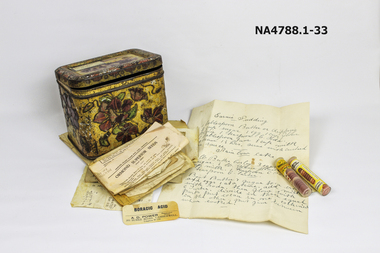
Container - Tin, 1897
Tin belonged to Martha Edwards (nee Course) who died in 1957. She was married in 1897. Martha was the donor's grandmother.William Course was an original settler in 6the area arriving in the area in1859. Martha was the 11th of 12 children. the boys of the family all worked at Geal Bros. potteries.A tin containing hand written recipes and two phials of junket tablets and Boracic acid label. Tin has a yellow background with flowers in purple and green leaves around all four sides.The top has a frame of flowers with a scene in the middle of a large building with trees around it. Many handwritten recipes inside with two junket tablet phials and a boracic acid label. A total of 33 items including the tin.Martha Edwards Recipe box 1950s. notice spicy smelldomestic items, cooking -
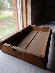 Parks Victoria - Days Mill and Farm
Functional object - Trays
Joseph Day was the son of Anne and William Day. He took over the running of the farm from his mother. It is unknown what specific use the trays had. They may have been used in the diary.WOODEN TRAYS. 4 x Wooden trays with metal handles and inscriptions.Side and underside of box "JD" ( initials for Joseph Day) -
Ballarat Heritage Services
Photograph, St Paul's Church of England, Steiglitz, 2020, 15/03/2020
The Steiglitz Cemetery is adjacent to the church. It closed in 1861, and by 2020 only one headstone remained. Photographs of St Paul's Church of England at Steiglitz. 1871 St Paul's Church of England Steigltiz The Dean of Melbourne consecrated this building as a church on the 3rd Day of March 1871. The final service was held on Sunday the 19th day of August 1962 by William R. Dowell. steiglitz, st paul's church of england -
 Ballarat Heritage Services
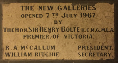
Photograph - Colour, Art Gallery of Ballarat Plaque, 04/07/2016
Photograph of a plaque in the entrance foyer of the Art Gallery of Ballarat.henry bolte, r.a. mccallum, william ritchie, art gallery of ballarat, ballarat fine art gallery -
 Ballarat Heritage Services
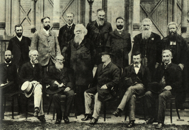
Image, Federation Convention, Melbourne, 1890, 1890
Black and white photographic image taken in Melbourne in 1890. During this meeting a draft constitution was becoming clearer. Back row: Andrew Inglis Clark, Captain William Russell (New Zealand), Sir Samuel Griffith, Sir Henry Parkes, Thomas Playford, Alfred Deakin, Bolton Stafford Bird, George Jenkins (Secretary to the Conference) Seated: William McMillan, Sir John Hall (New Zealand), John Macrossan, Duncan Gillies, Dr John Cockburn, Sir James Lee Steerefederation, federation convention, henry parkes, constitution, andrew inglis clark, captain william russell (new zealand), sir samuel griffith, sir henry parkes, thomas playford, alfred deakin, bolton stafford bird, george jenkins, william mcmillan, sir john hall, john macrossan, duncan gillies, dr john cockburn, sir james lee steere -
 Ballarat Heritage Services
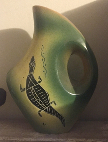
Ceramic - Photograph - Colour, Ceramics Decorated by Bill Onus, c1955
William (Bill) ONUS (15 November 1906-1968) Born Cummeragunja Aboriginal Reserve, Murray River, New South Wales Clan: Wiradjuri William Townsend (Bill) Onus was a shearer, actor and activist who revived the Australian Aboriginese League in Melbourne in 1946. He retired from politics in to start the Aboriginal Enterprises workship in Belgrave with his brother Eric. They produced boomerangs, woomeras, fabrics and greeting cards imprinted with Aboriginal motifs. He ran the business from his small factory and shop at Belgrave in the Dandenong Ranges. To promote his wares Bill Onus toured widely in Victoria and beyond as a travelling showman, giving demonstrations of boomerang-throwing, which he advocated as a national sport. (ADB) Bill Onus adopted similar imagery to that which appeared in mass-produced indigenised design; however, he used such works to draw attention to his political work with the ‘Committee for Aboriginal Citizen Rights’ and the ‘Australian Aborigines League.’ William McLintock (Lin) Onus is the son of Bill Onus. Ceramic form decorated with Aboriginal design by Bill Onus.aboriginal, bill onus, aboriginal enterprise novelties, ceramics -
 Ballarat Heritage Services
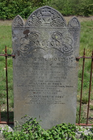
Photograph - Colour, Rees Headstone at the Franklinford Cemetery, 2015, 25/10/2015
William M. Rees was born at Gwter Fawr Gaermarthen Shire, South Wales"Sacred to the memory of Elizabeth W. Rees daughter of William and Margaret Rees. Yandoit Late of Chewton who died 31th (sic) 1866. Aged 3 years and 4 months. Also the aforesaid William M. Rees. Late of Gwter Fawr Gaermarthen Shie, South Wales. Who died Oct 10th 1868 aged 55 years. And Elizabeth Rees born May 9th 1866. Died March 8th 1870. Aged 3 Years and 10 months. frankinford cemetery, gwter fawr gaermarthen shire, south wales, william m. rees, elizabeth w. rees, elizabeth rees, yandoit, chewton, welsh, welsh language -
 Ballarat Heritage Services
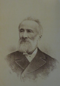
Image, William Bramwell Withers, c1887
Portrait of William Bramwell Withers, journalist and author of 'History of Ballarat.'william bramwell withers -
 Ballarat Heritage Services
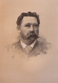
Image, William R. Guilfoyle, c1887
Portrait of William R. Guilfoylewilliam r. guilfoyle -
 Ballarat Heritage Services
Photograph - Colour, Prime Minister's Avenue of Honour during the Ballarat Begonia Festival, 2017, 2017
ballarat gardens, ballarat botanical gardens, prime ministers avenue of honour, begonia festival, billy mcmahon, william mcmahon -
 Ballarat Heritage Services
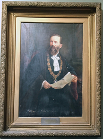
Photograph - Colour, William Little, 2017, 2017
Colour photograph of a mayor portrait of William Little. portrait, william little, mayor, ballarat -
 Ballarat Heritage Services
Photograph - Colour, Earth Banks, Old Sarum, England, 2016, 01 November 2016
William the Conqueror inherited Old Sarum from the last Saxon king of England. It was an ideal site for a royal castle. It was here in 1070 that William paid off his army after a long and bitter campaign in northern England. It was here in 1086 that he called together all the major landholders in England so they could swear allegiance to him. It was a crucial moment. The Domesday Book was being written, a threatened Viking invasion had only just been averted and William's eldest son was in armed rebellion. Old Sarum was an important place where this Norman king of England held power. In 1794 the Ordnance Survey set out to check the accuracy of the first mapping of Southern England, which had begun ten years earlier. From a point just below Old Sarum Lieutenant William Mudge laid out a base-line 36,574 feet (11,253 metres) long. From each end of the line the positions of distant places were plotted using a huge theodolite made in 1791 by Jesse Ramsden. The accuracy of the process, which was repeated all over England, depended on Jesse Ramsden's craftsmanship and on William Mudge's surveying skill in setting out this first base-line from Old Sarum. The nearer end of Mudge's line is marked by an inscribed stone beside the modern A345 at Old Sarum. ordnance survey, william mudge, jesse ramsden, william the conqueror, old sarum, saxon, 1086, england -
 Ballarat Heritage Services
Photograph - Colour, Earth Banks, Old Sarum, England, 01 November 2016
William the Conqueror inherited Old Sarum from the last Saxon king of England. It was an ideal site for a royal castle. It was here in 1070 that William paid off his army after a long and bitter campaign in northern England. It was here in 1086 that he called together all the major landholders in England so they could swear allegiance to him. It was a crucial moment. The Domesday Book was being written, a threatened Viking invasion had only just been averted and William's eldest son was in armed rebellion. Old Sarum was an important place where this Norman king of England held power. In 1794 the Ordnance Survey set out to check the accuracy of the first mapping of Southern England, which had begun ten years earlier. From a point just below Old Sarum Lieutenant William Mudge laid out a base-line 36,574 feet (11,253 metres) long. From each end of the line the positions of distant places were plotted using a huge theodolite made in 1791 by Jesse Ramsden. The accuracy of the process, which was repeated all over England, depended on Jesse Ramsden's craftsmanship and on William Mudge's surveying skill in setting out this first base-line from Old Sarum. The nearer end of Mudge's line is marked by an inscribed stone beside the modern A345 at Old Sarum. ordnance survey, william mudge, jesse ramsden, william the conqueror, old sarum, saxon, 1086, england -
 Ballarat Heritage Services
Photograph - Colour, Stonework, Old Sarum, England, English Heritage Site, 01 November 2016
William the Conqueror inherited Old Sarum from the last Saxon king of England. It was an ideal site for a royal castle. It was here in 1070 that William paid off his army after a long and bitter campaign in northern England. It was here in 1086 that he called together all the major landholders in England so they could swear allegiance to him. It was a crucial moment. The Domesday Book was being written, a threatened Viking invasion had only just been averted and William's eldest son was in armed rebellion. Old Sarum was an important place where this Norman king of England held power. In 1794 the Ordnance Survey set out to check the accuracy of the first mapping of Southern England, which had begun ten years earlier. From a point just below Old Sarum Lieutenant William Mudge laid out a base-line 36,574 feet (11,253 metres) long. From each end of the line the positions of distant places were plotted using a huge theodolite made in 1791 by Jesse Ramsden. The accuracy of the process, which was repeated all over England, depended on Jesse Ramsden's craftsmanship and on William Mudge's surveying skill in setting out this first base-line from Old Sarum. The nearer end of Mudge's line is marked by an inscribed stone beside the modern A345 at Old Sarum. ordnance survey, william mudge, jesse ramsden, william the conqueror, old sarum, saxon, 1086, england -
 Ballarat Heritage Services
Photograph - Colour, Stonework, Old Sarum, England, English Heritage Site, 2016, 01 November 2016
William the Conqueror inherited Old Sarum from the last Saxon king of England. It was an ideal site for a royal castle. It was here in 1070 that William paid off his army after a long and bitter campaign in northern England. It was here in 1086 that he called together all the major landholders in England so they could swear allegiance to him. It was a crucial moment. The Domesday Book was being written, a threatened Viking invasion had only just been averted and William's eldest son was in armed rebellion. Old Sarum was an important place where this Norman king of England held power. In 1794 the Ordnance Survey set out to check the accuracy of the first mapping of Southern England, which had begun ten years earlier. From a point just below Old Sarum Lieutenant William Mudge laid out a base-line 36,574 feet (11,253 metres) long. From each end of the line the positions of distant places were plotted using a huge theodolite made in 1791 by Jesse Ramsden. The accuracy of the process, which was repeated all over England, depended on Jesse Ramsden's craftsmanship and on William Mudge's surveying skill in setting out this first base-line from Old Sarum. The nearer end of Mudge's line is marked by an inscribed stone beside the modern A345 at Old Sarum. ordnance survey, william mudge, jesse ramsden, william the conqueror, old sarum, saxon, 1086, england