Showing 391 items matching "burning"
-
 Surrey Hills Historical Society Collection
Work on paper - Vertical file, City of Camberwell
A vertical file of clippings and general information relating to the City of Camberwell including: 1. Election notice, The Argus, 28.8.1937 (1 page). 2. “City news”: Council announces conservation position. Undated. (8 pages). 3. “Council to introduce new waste collection”. Undated Council publication. (4 pages). 4. Camberwell newsletter (incomplete, undated). (4 pages). 5. Camberwell City News, December 1983. (8 pages). 6. Camberwell City News, October, 1984. (8 pages). 7. City of Camberwell 1984/5 budget. (8 pages). 8. ‘’Recycling – It’s up to you’’ (source uncertain, like Council publication undated). (1 page). 9. ‘’Big bins arrive’’, Free Press, 1.2.1984. (1 page). 10. New bins photo and article – no heading; Free Press, 11 April 1884 with note re role of Cr Jim Rumpf. 11. Booklet: Camberwell Your City 82, 31 pages includes business ads as well as municipal information; published 1982. 12. Article re Richard Pearse, newly elected councillor re his philosophy; SHNN No 9, April / May 1984. 13. Article re Mary Drost, newly elected councillor re her philosophy; SHNN No 4, June / July, 1983. 14. Article re Irene Wegner, newly elected councillor re his philosophy; SHNN No 18, October / November 1985. 15. Article asking questions of ward candidates Patrick Trost and Alex Briggs, SHNN No 11, August / September 1984. 16. Articles re new councillors Jennie Carey and Sally Brentnall, SHNN No 39, April /May 1989. 17. Articles re views of ward candidates Wendy Nettle, David McCloskey and Alan Black, SHNN No 23, August / September 1986. 18. Article re CEO Brian Jones, SHNN No 39, April / may 1989. 19. Article questioning Council's conservation strategy in the light of proposed Red rooster development and forthcoming sale of then post office in Canterbury Road, SHHN No 64, June / July 1993. 20. Article urging voting at August 1992 local government elections; candidates mentioned: Bryan Steele, Joe Stanley, Ted Dugdale, Ilias Gouletas, Dennis Whelan, Phillip Barresi, SHNN No 59, August / September 1992. 21. Article re Phillip Barresi and Ilias Gouletsas - with photos, SHNN No 59, August / September 1992. 22. Article re Dennis Whelan and Ted Dugdale - with photos, SHNN No 59, August / September 1992. 23. Exhibition pamphlet: 'Camberwell - As we were' produced for Victoria's 150th anniversary, 3-21 June 1985. (REF: SH2023/1/2) 24. Pamphlet re Centenary of proclamation of Boroondara Shire, 17 November 1871; includes photos. (REF: SH2023/1/5) 25. Letter from John Paech to Miss V White of Barton Street re opposition to proposed transfer of part of Surrey Hills from City of Camberwell to City of Box Hill, dated 25 July 1986. NB/ Correspondant is Miss Val White. 26. City of Camberwell By-Law No 214 - Incinerator, BBQ & Open Air Burning By-Law, dated 20 April 1988. 27. City of Camberwell By-Law No 207 - Prevention & extinguishing fires, suppressing nuisances, and regulating times incinerators may be used; dated 16 July 1984. city of camberwell, cr jim rumpf, waste collection, recycling, local government -
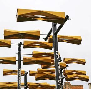 City of Ballarat
Artwork, other - Public Artwork, Aaron Robinson et al, Flow by Holly Grace and Aaron Robinson, 2014
Water is key to a thriving community and it is through the representation of water Flow enlivens the space at Bakery Hill. Historically ‘water races’ ran through the valleys of the Greater Ballarat area unearthing the minerals that forged prosperity and wealth. This water still flows today unearthing new possibilities for the community. Possibilities focusing on sustainability, ecology, health and prosperity. Flowing over the site a series of kinetic turbines flutter in the wind creating a contemporary water race. The interactive elements offer visual stimulation enticing people to connect with the artwork and in turn the surrounding spaces. Bakery Hill has great historical significance. It’s connection to the Eureka Stockade and the series of events that were to unfold during the 1850’s was to become the turning point in Australian political history. The placement of each turbine is to mirror a point of history in the timeline of events that occurred during the Eureka Stockade. The Water Race is a symbol of possibilities, the ones created by history and those of modern society. It is a visual timeline that can be read by traversing the site. The connecting turbines that flow and turn in sync are a representation of time passing and the interconnectedness of history with the community that surrounds it. The gateway to Bridge Mall is framed through the placement of each turbine allowing the sense of prosperity and wealth to flow through to the surrounding community. This gateway also references the significance of Bakery Hill reinvigorating the historical site by reconnecting it back to its town centre. The artwork is of aesthetic and historical significance to the people of BallaratTwelve steel turbines set on poles with dates attached and a large bronze 'timeline' plaqueFLOW/ Plotting the motion of Wind, Water, History and Time/ by Holly Grace and Aaron Robinson/ This site has great historical significance. It’s connection to the Eureka Stockade and the series of events that unfolded in the 1850’s was to become the turning point in Australian history. The placement of each turbine within this artwork mirrors a point of history in the events that led up to the Eureka Stockade. It is a visual timeline that can be read by traversing the site. The connecting turbines that flow and turn in sync are a representation of time passing. They are a symbol of the community’s connection to their history. 1851 June James Esmond makes the first discovery of gold in Victoria at Clunes./ 1st July The Port Phillip District separates from New South Wales and becomes the Colony of Victoria. It is still subject to British rule./ August Gold is discovered at Buninyong and at Golden Point, Ballarat. Lt-Governor La Trobe introduces the Gold Licence system in an attempt to reduce the colony’s debt./ 20th September First gold licences issued in Ballarat. / 1852 August/ Eureka Lead discovered on the Ballarat goldfields. December Charles La Trobe resigns as Lt-Governor but he is not relieved until 1854/ July – December/ Unrest builds on the various goldfields with protest meetings held in Bendigo and Castlemaine. Bendigo’s Red Ribbon Movement is active on the goldfields and the Bendigo Petition is presented to Lt-Governor./ December/ Charles Hotham is appointed Lt-Governor/ 1854 March/ A bill to extend the Elective Franchise is passed by the Legislative Council and sent to London for the assent of the British Parliament. 22nd June/ Lt-Governor Sir Charles Hotham arrives in Victoria. The colony faces mounting debt and Hotham orders weekly licence hunts in an attempt to increase income./ August/ Hotham is acclaimed during his visit to the Ballarat goldfield./ 13th September? Hotham orders twice-weekly licence hunts to further increase revenue./ September – October/ Miners are experiencing problems – no shafts bottomed on the Eureka Lead for five weeks./ 7th October/ James Scobie is murdered outside the Eureka Hotel. Many diggers believe that publican James Bentley is responsible./ 9th October/ At Scobie’s inquest, Bentley is acquitted, despite strong evidence of his guilt./ 10th October/ Father Smythe’s servant is beaten up by authorities and falsely arrested for not holding a licence./ 15th October/ Mass meeting of miners on Bakery Hill. Catholic miners meet after Mass. // 17th October/ A meeting of up to 10,000 Diggers is held near the Eureka Hotel to protest against Bentley’s acquittal. The meeting results in the burning of the hotel. Three diggers, Westerby, Fletcher and McIntyre, are arrested. Hotham dispatches 400 soldiers to Ballarat. 22nd October/ Another large meeting is held to address grievances. The Catholics send their leaders, Hayes, Kennedy and Manning to meet Rede. The Government Camp is under siege 11th November/ A public meeting on Bakery Hill results in the formal establishment of the Ballarat Reform League and adoption of the League’s proposals./ 21st November/ The enquiry into the Bentley affair is published. It recommends the dismissal of the judge and the establishment of a Royal Commission. 23rd November/ Westerby, Fletcher and McIntyre are convicted of burning the hotel. The Ballarat Reform League demands their release. 27th November/ A deputation from The Ballarat Reform League, including Humffray, Black and Kennedy, meet with Hotham to demand the release of the three prisoners. Hotham does not believe the diggers have the right to “demand anything”, Rede requests reinforcements in Ballarat. 28th November/ Miners attack the troop reinforcements and wagons passing near the Eureka diggings. A drummer boy is seriously wounded. 29th November/ A “Monster Meeting” attended by more than 10,000 diggers is held on Bakery Hill. The Southern Cross flag is flown for the first time. Peter Lalor addresses the miners and a number of diggers burn their licences. 30th November/ A licence hunt occurs in the morning at the order of Commissioner Rede. Another meeting of radical miners is held on Bakery Hill. Peter Lalor becomes leader of the diggers and calls for volunteers. Many diggers wear an oath to defend their rights and liberties under the Southern Cross flag. A number of diggers move to the Eureka Lead and start to erect a stockade. 3rd December In the early hours of Sunday morning 296 soldiers and police led by Captain Thomas proceed from the Government Camp to the Eureka Lead and attack the Stockade. 22 diggers and 7 military are officially listed as being killed. Many others are wounded. Approximately 120 diggers are arrested and marched to the Government Camp. 4th December/ Funeral of some of the fallen diggers and soldiers. Martial Law is proclaimed in Ballarat. Henry Seekamp, editor of the Ballarat Times is charged with seditious libel. 6th December/ Major General Sir Robert Nickle, commander-in-chief of the military forces in the Australian colonies, arrives in Ballarat. 9th December/ General Nickle repeals martial law. 14th December/ The Gold Fields Commission sits for the first time. 18th December/ The first Ballarat sitting of the Gold Fields Commission is held at Bath’s Hotel. 1855 23rd January/ Henry Seekamp is found guilt of sedition and sentenced to three months in prison. 22nd February/ The Eureka trials starts in Melbourne. February to March/ 13 prisoners are tried and acquitted amid great public rejoicing. 27th March Report of the Royal Commission recommends miners’ rights and significant reforms. 10th November/ Peter Lalor and John Basson Humffray are nominated for seats in the legislative Council. 31st December Sir Charles Hotham dies before his resignation takes effect. flow, aaron robinson, holly grace, public art, eureka stockade, bakery hill -
 Flagstaff Hill Maritime Museum and Village
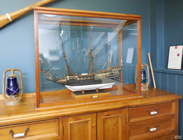
Craft - Ship Model, Sovereign of the Seas, Made between 1930-1955
This meticulously hand crafted ship model is one of the most intricate and challenging projects for a ship modeller to create. Jim Williams took up the challenge, choosing to make all of the components by hand, following a plan of the ship rather than purchasing a pre-made kit. He even made his own tools specifically for working with this model. The “Sovereign of the Seas” 1637-1697 - The magnificent ship “Sovereign of the Seas” was ordered by Charles I of England, who desired a giant Great Ship to be built. It was built by Peter Pett under the guidance of his father Phineas, the King's master shipwright, and launched with 102-guns at Woolwich Dockyard on 13th October 1637, as the Navy’s second three-decker first-rate ship. It was the most extravagantly decorated warship in the Royal Navy, bought with the help of a special 'Ship Money' tax imposed by the King. Soon afterwards the ship was remodelled and cut down to a safer and faster ship. Over the ship’s lifetime it was renamed “Commonwealth”, then in 1650 it became simply “Sovereign” then again after a rebuild in 1660 it was named “Royal Sovereign”. By 1642 the ship’s armament had been reduced to 90 guns. In 1651 Sovereign was made more manoeuvrable by reducing the upper works. It served throughout the wars of the Commonwealth and became the flagship of General Robert Blake. It was involved in all of the great English naval conflicts fought against the United Provinces and France and was referred to as 'The Golden Devil' by the Dutch. By 1660 the armament was changed attain to 100 guns. After the English Restoration, it was rebuilt as a first-rate ship of the line, with flatter gun decks and 100 guns, and most of the carvings were removed. During the First Anglo-Dutch War, in a secret session on 21 October 1652, the States-General of the Netherlands announced reward money for the crews of fire ships that succeeded in destroying enemy vessels; the Sovereign was singled out with an extra prize of 3000 guilders to sink or ruin it. Although repeatedly occupied by the Dutch, the Sovereign was retaken every time by the British and remained in service for nearly sixty years as the best ship in the English fleet. The Sovereign was in regular service during the three Anglo-Dutch Wars, surviving the Raid on the Medway in 1667. After a second rebuild in 1685 the Sovereign was relaunched as a first-rate ship of 100 guns, before taking part in the outset of the War of the Grand Alliance against Louis XIV of France, venturing into the Irish Sea, and later participating in the Battle of Beachy Head in 1690 and the Battle of La Hougue. At this time she was more than fifty years old. It was the first ship in history to fly ‘royals’ above the topgallant sails and a top gallant sail on the jigger-mast. The Sovereign eventually became leaky and defective with age and was laid up at Chatham when, on 27th January 1697, the famous ship caught fire, burning to the waterline. Jim Williams, the model’s maker - Jim (James Bernard) Williams was born in 1888 at The Forth in Scotland. He lived in Tasmania for some time and enlisted to fight in France in WW1. After the war he moved to Warrnambool, Victoria, where he worked at the Cramond & Dickson clothing store until the Great Depression in the 1930’s. He was later employed at Fletcher Jones Menswear, where he worked for 27 years until just before his death in 1959. Jim was a passionate ship model builder. He worked on his model ships between 1930 and 1955, including The Endeavour and The Sovereign of the Seas, which was one of the most intricate historic ship models to build. He had a table set up in a bay window and worked on them on and off using a jeweller's eye glass on the finer pieces. Jim’s long-time employer, Fletcher Jones, knew of Jim’s hobby and skill as a ship model builder and requested Jim to describe the model, Sovereign of the Seas, with the view of putting it on display. When the model was finished there was a full article and photo in The Standard newspaper. Jim described his work on the ship mode “Sovereign of the Seas” in correspondence to his then employer, Fletcher Jones. The document gives us an insight into his skill, patience, and regard for replicating the details of the original ship. Some of the details are: "In making the model the time taken to make certain items might be of interest. For instance "The Great Lantern" on the stern, four weeks, a similar time for the figurehead of St George & the Dragon. "The lower shrouds three to each side about six weeks & the rigging as whole several months. There are nearly 300 blocks and pulleys ranging from nearly 1 / 16 inch in diameter. Dead eyes were bored with 3 to 5 holes. To do this needles of different sizes, set in handles & ground to wedge ends were used. Glass cut and ground to shape were used windows. All gun-port covers (74) hinged. "All guns and anchors made of wood. Nothing for the model was purchased ready-made; everything hand made." Jim’s family donated the ship model along with many associated tools, accessories and papers. The model represents the Sovereign of the Seas. The Royal Navy ship of the line launched in 1637 has a significant British maritime heritage. These days the Sovereign of the Seas still remains one of the most intricate historic ship models to build, representing to the model enthusiast a true challenge to the art of model shipbuilding. The model of Sovereign of the Seas in Flagstaff Hill's collection is an exemplary example of a ship model built and hand crafted from a plan with the making of every item on the model, not a model kit with prefabricated parts. It was made by a local Warrnambool man Jim Williams as a leisure activity in the mid 20th century. The hobby and craft of ship model making has resulted in visual representations of the changes in maritime technology and advances in world-wide navigation. Ship model of HMS Sovereign of the Seas, a 17th century British warship. The handmade model is in wooden framed, airtight glass case. All components were hand crafted. Many of the tools used were made by the model maker, Jim Williams. An inscribed plaque is within the case. Inscribed on plaque "SOVEREIGN OF THE SEAS / 102 GUNS - 1634"flagstaff hill, warrnambool, shipwrecked coast, flagstaff hill maritime museum, maritime museum, shipwreck coast, flagstaff hill maritime village, great ocean road, model ship, vessel sovereign of the seas, jim williams, james bernard williams, the forth tasmania, freda williams, heather williams, phyllis bowditch, fletcher jones staff 1936, 17th century sailing ship, cramond and dickson, sovereign of the seas, royal sovereign, sovereign, charles 1, ship model -
 Eltham District Historical Society Inc
Photograph, Hume and Hovell passed here at Seymour 28 Oct 1824, Spring Excursion, Hume and Hovell's 1824 expedition (Part 2), 26 October 1997, 26/10/1997
[article by Diana Bassett-Smith in EDHS Newsletter No. 117, November 1997:] MONUMENT HUNTING THE HUME AND HOVELL WAY - Sunday October 26 1997 dawned bright and very warm. Some twenty-five members, complete with picnic baskets, met outside the Eltham Library awaiting the Cobb and Co. large coach which would be taking us on the second leg of our travels along the route of the early explorers Hume and Hovell. Stephen West was our very good driver for the day. He would be guided around the circuitous route by Russell Yeoman who had made a detailed study, not only of the intended route, but of the story of these two explorers. During the trip Russell regaled us with poetry, quotations from the Journals and the History of the Shire of Seymour, "The New Crossing Place" by Martindale, 1982, (now Mitchell Shire due to the recent amalgamations). We headed towards the Hume Highway via Greensborough and Cooper Street and proceeded north to our first stop, noting on the way Monument Hill in the distance which is near Kilmore and, according to Russell, well worth the effort to visit as the view across the valley is magnificent. Past Sunday Creek Valley, Mt Piper and Mt Disappointment, all traversed and noted and named by them. We passed through Tallarook, then onto Seymour where we took photos of the monument telling us that Hume and Hovell had passed through on the 28th of October 1824. We also deviated down Hume and Hovell Road viewing deer and emu farming and the Bellbourie property now a sanctuary. Leaving Seymour behind we travelled up the Avenel Road to the Avenel monument, pyramidal in design of four reducing square blocks with a sharply pointed peak, erected in 1924 in memory of the 1824 exploration. The day was warming up and the countryside showing the dryness of the current drought. A parallel note had been made in their journal too of 1824 of the drought appearance of the country they were traversing. At Seven Creeks, Euroa we stopped for some minutes to check the monument placed 20th November 1924 to commemorate their passage on the 29th December 1824. More photos. Russell had pointed out the abrupt termination of the distant ranges which is noted in their journal. The next monument is beside the road at the entrance to Honey Suckle Creek Caravan Park, Violet Town. The squarish shaped monument some eight feet high is topped with a simple steel cross, and was to mark the date of 28th December 1824 and built for the 20th November 1924. By now it was 12.20 and nearly lunchtime as we drove along the Warranbayne Road to Roach's Road, monument hunting without success. Though there is a large, what appears to be an old timber sign which was hard to read, maybe this was the lost monument. In many of the paddocks hay had been cut and baled or was being cut, what a contrast to the rugged country they had passed through which was smoky from the fires of the natives burning off. By 1.00 pm we were at Benalla and pulled up beside the park where abundant beds of roses filled the air with their scent and the smell of barbecued food twitched the nostrils whilst the cheerful sounds of other picnickers could be heard throughout the park. We left the bus and collected up our picnics, dispersed to the various tables and enjoyed the shade from the various European trees. 2.00 pm and we were on the road again driving along the Benalla, Mansfield, Yea road. The Swanpool monument states that they passed four miles south and returned three miles north. Then we stopped at the Barjarg monument which notes that they camped near this spot. It is again a pyramidal monument and this time topped with a steel arrow indicating their route of the 29th November 1824. Half an hour later we came to another monument, again with a steel arrow marker on top and the plaque dated the 2nd of 12th 1824. Erected on the 12th of 12th 1924. "They blazed the way that we might inherit the land." Another square based and needle topped monument appeared at Yarck near Yea and this plaque records the date of 3 December 1824. Near McGuigans Road Russell related that the expedition had lost a dog but it had found them next day, the dog was apparently torn by a kangaroo. A short while later Russell reminded us here of the problems they encountered in crossing the Goulburn River near Molesworth where banks were high, water deep and wide. "Good coat of grass but quite dry due to drought". At Yea we stopped for afternoon tea and raided the last of our picnics and looked at the monument to their journey of 1824, situated at a corner of the gardens near the bowling green. No photo – we were out of film. We returned home via Kinglake West and Whittlesea past the Yan Yean Reservoir, not full. 5.00 pm back at Eltham we emptied out of the bus and everyone, including Joan Cole, collected their things, Joan also had the major souvenir of the day, a large carp she had picked up from the river bank, her cat was in for a great feast. The day was made so interesting by the informed commentary which Russell provided. His background knowledge of the route and nature of the journey could only have come from many hours of reading and driving the area. Thank you to Russell and to everyone who made the day so informative and pleasurable. Colour photographactivities, hume and hovell, monument, seymour -
 Eltham District Historical Society Inc
Photograph, Spring Excursion, Hume and Hovell's 1824 expedition (Part 2), 26 October 1997, 26/10/1997
[article by Diana Bassett-Smith in EDHS Newsletter No. 117, November 1997:] MONUMENT HUNTING THE HUME AND HOVELL WAY - Sunday October 26 1997 dawned bright and very warm. Some twenty-five members, complete with picnic baskets, met outside the Eltham Library awaiting the Cobb and Co. large coach which would be taking us on the second leg of our travels along the route of the early explorers Hume and Hovell. Stephen West was our very good driver for the day. He would be guided around the circuitous route by Russell Yeoman who had made a detailed study, not only of the intended route, but of the story of these two explorers. During the trip Russell regaled us with poetry, quotations from the Journals and the History of the Shire of Seymour, "The New Crossing Place" by Martindale, 1982, (now Mitchell Shire due to the recent amalgamations). We headed towards the Hume Highway via Greensborough and Cooper Street and proceeded north to our first stop, noting on the way Monument Hill in the distance which is near Kilmore and, according to Russell, well worth the effort to visit as the view across the valley is magnificent. Past Sunday Creek Valley, Mt Piper and Mt Disappointment, all traversed and noted and named by them. We passed through Tallarook, then onto Seymour where we took photos of the monument telling us that Hume and Hovell had passed through on the 28th of October 1824. We also deviated down Hume and Hovell Road viewing deer and emu farming and the Bellbourie property now a sanctuary. Leaving Seymour behind we travelled up the Avenel Road to the Avenel monument, pyramidal in design of four reducing square blocks with a sharply pointed peak, erected in 1924 in memory of the 1824 exploration. The day was warming up and the countryside showing the dryness of the current drought. A parallel note had been made in their journal too of 1824 of the drought appearance of the country they were traversing. At Seven Creeks, Euroa we stopped for some minutes to check the monument placed 20th November 1924 to commemorate their passage on the 29th December 1824. More photos. Russell had pointed out the abrupt termination of the distant ranges which is noted in their journal. The next monument is beside the road at the entrance to Honey Suckle Creek Caravan Park, Violet Town. The squarish shaped monument some eight feet high is topped with a simple steel cross, and was to mark the date of 28th December 1824 and built for the 20th November 1924. By now it was 12.20 and nearly lunchtime as we drove along the Warranbayne Road to Roach's Road, monument hunting without success. Though there is a large, what appears to be an old timber sign which was hard to read, maybe this was the lost monument. In many of the paddocks hay had been cut and baled or was being cut, what a contrast to the rugged country they had passed through which was smoky from the fires of the natives burning off. By 1.00 pm we were at Benalla and pulled up beside the park where abundant beds of roses filled the air with their scent and the smell of barbecued food twitched the nostrils whilst the cheerful sounds of other picnickers could be heard throughout the park. We left the bus and collected up our picnics, dispersed to the various tables and enjoyed the shade from the various European trees. 2.00 pm and we were on the road again driving along the Benalla, Mansfield, Yea road. The Swanpool monument states that they passed four miles south and returned three miles north. Then we stopped at the Barjarg monument which notes that they camped near this spot. It is again a pyramidal monument and this time topped with a steel arrow indicating their route of the 29th November 1824. Half an hour later we came to another monument, again with a steel arrow marker on top and the plaque dated the 2nd of 12th 1824. Erected on the 12th of 12th 1924. "They blazed the way that we might inherit the land." Another square based and needle topped monument appeared at Yarck near Yea and this plaque records the date of 3 December 1824. Near McGuigans Road Russell related that the expedition had lost a dog but it had found them next day, the dog was apparently torn by a kangaroo. A short while later Russell reminded us here of the problems they encountered in crossing the Goulburn River near Molesworth where banks were high, water deep and wide. "Good coat of grass but quite dry due to drought". At Yea we stopped for afternoon tea and raided the last of our picnics and looked at the monument to their journey of 1824, situated at a corner of the gardens near the bowling green. No photo – we were out of film. We returned home via Kinglake West and Whittlesea past the Yan Yean Reservoir, not full. 5.00 pm back at Eltham we emptied out of the bus and everyone, including Joan Cole, collected their things, Joan also had the major souvenir of the day, a large carp she had picked up from the river bank, her cat was in for a great feast. The day was made so interesting by the informed commentary which Russell provided. His background knowledge of the route and nature of the journey could only have come from many hours of reading and driving the area. Thank you to Russell and to everyone who made the day so informative and pleasurable. Colour photographactivities, hume and hovell, bridge -
 Eltham District Historical Society Inc
Photograph, Spring Excursion, Hume and Hovell bus tour Stage 2, Seymour, Benalla; 26 Oct 1997, 26/10/1997
MONUMENT HUNTING THE HUME AND HOVELL WAY (Newsletter No. 117, November 1997, by Diana Bassett-Smith) Sunday October 26 1997 dawned bright and very warm. Some twenty-five members, complete with picnic baskets, met outside the Eltham Library awaiting the Cobb and Co. large coach which would be taking us on the second leg of our travels along the route of the early explorers Hume and Hovell. Stephen West was our very good driver for the day. He would be guided around the circuitous route by Russell Yeoman wh9 had made a detailed study, not only of the intended route, but of the story of these two explorers. During the trip Russell regaled us with poetry, quotations from the Journals and the History of the Shire of Seymour, "The New Crossing Place: by Martindale, 1982, (now Mitchell Shire due to the recent amalgamations). We headed towards the Hume Highway via Greensborough and Cooper Street and proceeded north to our first stop, noting on the way Monument Hill in the distance which is near Kilmore and, according to Russell, well worth the effort to visit as the view across the valley is magnificent. Past Sunday Creek Valley, Mt Piper and Mt Disappointment, all traversed and noted and named by them. We passed through Tallarook, then onto Seymour where we took photos of the monument telling us that Hume and Hovell had passed through on the 28th of October 1824. We also deviated down Hume and Hovell Road viewing deer and emu farming and the Bellbourie property now a sanctuary. Leaving Seymour behind we travelled up the Avenel Road to the Avenel monument, pyramidal in design of four reducing square blocks with a sharply pointed peak, erected in 1924 in memory of the 1824 exploration. The day was warming up and the countryside showing the dryness of the current drought. A parallel note had been made in their journal too of 1824 of the drought appearance of the country they were traversing. At Seven Creeks, Euroa we stopped for some minutes to check the monument placed 20th November 1924 to commemorate their passage on the 29th December 1824. More photos. Russell had pointed out the abrupt termination of the distant ranges which is noted in their journal. The next monument is beside the road at the entrance to Honey Suckle Creek Caravan Park, Violet Town. The squarish shaped monument some eight feet high is topped with a simple steel cross, and was to mark the date of 28th December 1824 and built for the 20th November 1924. By now it was 12.20 and nearly lunchtime as we drove along the Warranbayne Road to Roach's Road, monument hunting without success. Though there is a large, what appears to be an old timber sign which was hard to read, maybe this was the lost monument. In many of the paddocks hay had been cut and baled or was being cut, what a contrast to the rugged country they had passed through which was smoky from the fires of the natives burning off By 1.00 pm we were at Benalla and pulled up beside the park where abundant beds of roses filled the air with their scent and the smell of barbecued food twitched the nostrils whilst the cheerful sounds of other picnickers could be heard throughout the park. We left the bus and collected up our picnics, dispersed to the various tables and enjoyed the shade from the various European trees. 2.00 pm and we were on the road again driving along the Benalla, Mansfield, Yea road. The Swanpool monument states that they passed four miles south and returned three miles north. Then we stopped at the Barjarg monument which notes that they camped near this spot. It is again a pyramidal monument and this time topped with a steel arrow indicating their route of the 29th November 1824. Half an hour later we came to another monument, again with a steel arrow marker on top and the plaque dated the 2nd of 12th 1824. Erected on the 12th of 12th 1924. "They blazed the way that we might inherit the land." Another square based and needle topped monument appeared at Yarck near Yea and this plaque records the date of 3 December 1824. Near McGuigans Road Russell related that the expedition had lost a dog but it had found them next day, the dog was apparently torn by a kangaroo. A short while later Russell reminded us here of the problems they encountered in crossing the Goulburn River near Molesworth where banks were high, water deep and wide. "Good coat of grass but quite dry due to drought". At Yea we stopped for afternoon tea and raided the last of our picnics and looked at the monument to their journey of 1824, situated at a corner of the gardens near the bowling green. No photo – we were out of film. We returned home via Kinglake West and Whittlesea past the Yan Yean Reservoir, not full. 5.00 pm back at Eltham we emptied out of the bus and everyone, including Joan Cole, collected their things, Joan also had the major souvenir of the day, a large carp she had picked up from the river bank, her cat was in for a great feast. The day was made so interesting by the informed commentary which Russell provided. His background knowledge of the route and nature of the journey could only have come from many hours of reading and driving the area. Thank you to Russell and to everyone who made the day so informative and pleasurable. Diana Bassett-Smith. Record of the Society's history of activities - Spring 1997 excursionRoll of 35mm colour negative film, 6 stripsFuji 200shire of eltham historical society, activities, pretty hill, seymour, benalla, hume and hovell, monuments -
 Eltham District Historical Society Inc
Photograph, Spring Excursion, Hume and Hovell bus tour Stage 2, Seymour, Benalla; 26 Oct 1997, 26/10/1997
MONUMENT HUNTING THE HUME AND HOVELL WAY (Newsletter No. 117, November 1997, by Diana Bassett-Smith) Sunday October 26 1997 dawned bright and very warm. Some twenty-five members, complete with picnic baskets, met outside the Eltham Library awaiting the Cobb and Co. large coach which would be taking us on the second leg of our travels along the route of the early explorers Hume and Hovell. Stephen West was our very good driver for the day. He would be guided around the circuitous route by Russell Yeoman wh9 had made a detailed study, not only of the intended route, but of the story of these two explorers. During the trip Russell regaled us with poetry, quotations from the Journals and the History of the Shire of Seymour, "The New Crossing Place: by Martindale, 1982, (now Mitchell Shire due to the recent amalgamations). We headed towards the Hume Highway via Greensborough and Cooper Street and proceeded north to our first stop, noting on the way Monument Hill in the distance which is near Kilmore and, according to Russell, well worth the effort to visit as the view across the valley is magnificent. Past Sunday Creek Valley, Mt Piper and Mt Disappointment, all traversed and noted and named by them. We passed through Tallarook, then onto Seymour where we took photos of the monument telling us that Hume and Hovell had passed through on the 28th of October 1824. We also deviated down Hume and Hovell Road viewing deer and emu farming and the Bellbourie property now a sanctuary. Leaving Seymour behind we travelled up the Avenel Road to the Avenel monument, pyramidal in design of four reducing square blocks with a sharply pointed peak, erected in 1924 in memory of the 1824 exploration. The day was warming up and the countryside showing the dryness of the current drought. A parallel note had been made in their journal too of 1824 of the drought appearance of the country they were traversing. At Seven Creeks, Euroa we stopped for some minutes to check the monument placed 20th November 1924 to commemorate their passage on the 29th December 1824. More photos. Russell had pointed out the abrupt termination of the distant ranges which is noted in their journal. The next monument is beside the road at the entrance to Honey Suckle Creek Caravan Park, Violet Town. The squarish shaped monument some eight feet high is topped with a simple steel cross, and was to mark the date of 28th December 1824 and built for the 20th November 1924. By now it was 12.20 and nearly lunchtime as we drove along the Warranbayne Road to Roach's Road, monument hunting without success. Though there is a large, what appears to be an old timber sign which was hard to read, maybe this was the lost monument. In many of the paddocks hay had been cut and baled or was being cut, what a contrast to the rugged country they had passed through which was smoky from the fires of the natives burning off By 1.00 pm we were at Benalla and pulled up beside the park where abundant beds of roses filled the air with their scent and the smell of barbecued food twitched the nostrils whilst the cheerful sounds of other picnickers could be heard throughout the park. We left the bus and collected up our picnics, dispersed to the various tables and enjoyed the shade from the various European trees. 2.00 pm and we were on the road again driving along the Benalla, Mansfield, Yea road. The Swanpool monument states that they passed four miles south and returned three miles north. Then we stopped at the Barjarg monument which notes that they camped near this spot. It is again a pyramidal monument and this time topped with a steel arrow indicating their route of the 29th November 1824. Half an hour later we came to another monument, again with a steel arrow marker on top and the plaque dated the 2nd of 12th 1824. Erected on the 12th of 12th 1924. "They blazed the way that we might inherit the land." Another square based and needle topped monument appeared at Yarck near Yea and this plaque records the date of 3 December 1824. Near McGuigans Road Russell related that the expedition had lost a dog but it had found them next day, the dog was apparently torn by a kangaroo. A short while later Russell reminded us here of the problems they encountered in crossing the Goulburn River near Molesworth where banks were high, water deep and wide. "Good coat of grass but quite dry due to drought". At Yea we stopped for afternoon tea and raided the last of our picnics and looked at the monument to their journey of 1824, situated at a corner of the gardens near the bowling green. No photo – we were out of film. We returned home via Kinglake West and Whittlesea past the Yan Yean Reservoir, not full. 5.00 pm back at Eltham we emptied out of the bus and everyone, including Joan Cole, collected their things, Joan also had the major souvenir of the day, a large carp she had picked up from the river bank, her cat was in for a great feast. The day was made so interesting by the informed commentary which Russell provided. His background knowledge of the route and nature of the journey could only have come from many hours of reading and driving the area. Thank you to Russell and to everyone who made the day so informative and pleasurable. Diana Bassett-Smith. Record of the Society's history of activities - Spring 1997 excursionRoll of 35mm colour negative film, 2 stripsKodak Gold 400-5shire of eltham historical society, activities, pretty hill, seymour, benalla, hume and hovell, monuments -
 Eltham District Historical Society Inc
Photograph, Spring Excursion, Hume and Hovell bus tour Stage 2, Seymour, Benalla; 26 Oct 1997, 26/10/1997
MONUMENT HUNTING THE HUME AND HOVELL WAY (Newsletter No. 117, November 1997, by Diana Bassett-Smith) Sunday October 26 1997 dawned bright and very warm. Some twenty-five members, complete with picnic baskets, met outside the Eltham Library awaiting the Cobb and Co. large coach which would be taking us on the second leg of our travels along the route of the early explorers Hume and Hovell. Stephen West was our very good driver for the day. He would be guided around the circuitous route by Russell Yeoman wh9 had made a detailed study, not only of the intended route, but of the story of these two explorers. During the trip Russell regaled us with poetry, quotations from the Journals and the History of the Shire of Seymour, "The New Crossing Place: by Martindale, 1982, (now Mitchell Shire due to the recent amalgamations). We headed towards the Hume Highway via Greensborough and Cooper Street and proceeded north to our first stop, noting on the way Monument Hill in the distance which is near Kilmore and, according to Russell, well worth the effort to visit as the view across the valley is magnificent. Past Sunday Creek Valley, Mt Piper and Mt Disappointment, all traversed and noted and named by them. We passed through Tallarook, then onto Seymour where we took photos of the monument telling us that Hume and Hovell had passed through on the 28th of October 1824. We also deviated down Hume and Hovell Road viewing deer and emu farming and the Bellbourie property now a sanctuary. Leaving Seymour behind we travelled up the Avenel Road to the Avenel monument, pyramidal in design of four reducing square blocks with a sharply pointed peak, erected in 1924 in memory of the 1824 exploration. The day was warming up and the countryside showing the dryness of the current drought. A parallel note had been made in their journal too of 1824 of the drought appearance of the country they were traversing. At Seven Creeks, Euroa we stopped for some minutes to check the monument placed 20th November 1924 to commemorate their passage on the 29th December 1824. More photos. Russell had pointed out the abrupt termination of the distant ranges which is noted in their journal. The next monument is beside the road at the entrance to Honey Suckle Creek Caravan Park, Violet Town. The squarish shaped monument some eight feet high is topped with a simple steel cross, and was to mark the date of 28th December 1824 and built for the 20th November 1924. By now it was 12.20 and nearly lunchtime as we drove along the Warranbayne Road to Roach's Road, monument hunting without success. Though there is a large, what appears to be an old timber sign which was hard to read, maybe this was the lost monument. In many of the paddocks hay had been cut and baled or was being cut, what a contrast to the rugged country they had passed through which was smoky from the fires of the natives burning off By 1.00 pm we were at Benalla and pulled up beside the park where abundant beds of roses filled the air with their scent and the smell of barbecued food twitched the nostrils whilst the cheerful sounds of other picnickers could be heard throughout the park. We left the bus and collected up our picnics, dispersed to the various tables and enjoyed the shade from the various European trees. 2.00 pm and we were on the road again driving along the Benalla, Mansfield, Yea road. The Swanpool monument states that they passed four miles south and returned three miles north. Then we stopped at the Barjarg monument which notes that they camped near this spot. It is again a pyramidal monument and this time topped with a steel arrow indicating their route of the 29th November 1824. Half an hour later we came to another monument, again with a steel arrow marker on top and the plaque dated the 2nd of 12th 1824. Erected on the 12th of 12th 1924. "They blazed the way that we might inherit the land." Another square based and needle topped monument appeared at Yarck near Yea and this plaque records the date of 3 December 1824. Near McGuigans Road Russell related that the expedition had lost a dog but it had found them next day, the dog was apparently torn by a kangaroo. A short while later Russell reminded us here of the problems they encountered in crossing the Goulburn River near Molesworth where banks were high, water deep and wide. "Good coat of grass but quite dry due to drought". At Yea we stopped for afternoon tea and raided the last of our picnics and looked at the monument to their journey of 1824, situated at a corner of the gardens near the bowling green. No photo – we were out of film. We returned home via Kinglake West and Whittlesea past the Yan Yean Reservoir, not full. 5.00 pm back at Eltham we emptied out of the bus and everyone, including Joan Cole, collected their things, Joan also had the major souvenir of the day, a large carp she had picked up from the river bank, her cat was in for a great feast. The day was made so interesting by the informed commentary which Russell provided. His background knowledge of the route and nature of the journey could only have come from many hours of reading and driving the area. Thank you to Russell and to everyone who made the day so informative and pleasurable. Diana Bassett-Smith. Record of the Society's history of activities - Spring 1997 excursionRoll of 35mm colour negative film, 2 stripsKodak Gold 400-5shire of eltham historical society, activities, pretty hill, seymour, benalla, hume and hovell, monuments