Showing 326 items
matching central planning
-
 Bacchus Marsh & District Historical Society
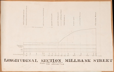
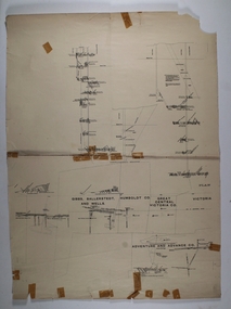
Drawing, Longitudinal Section Millbank Street Bacchus Marsh circa 1905
Millbank Street is a short street located close to the central business and shopping area of Bacchus Marsh. In the early 1900s works to improve the drainage of the street were discussed and planned by Bacchus Marsh Shire Council. This plan is most probably the plan discussed at a Shire Council meeting in April 1905. Single page plan showing a longitudinal section view of MIllbank Street running from Clarinda Street to Grant Street in Bacchus Marsh. The names of Millbank Street property owners, Cain, Shelley, Oliver and Ramsay are marked on this plan. Scale: Vertical 10 feet to 1 inch. Horizontal: 100 links to 1 inch Part of a set of maps which are pasted into a bound volume containing 76 maps or plans in total. High resolution digital image stored on BMDHS computer network. bacchus marsh victoria maps, millbank street bacchus marsh -
 Bendigo Historical Society Inc.
Document - RAE'S CRUSHING BATTERY - THE RICH VICTORIA HILL & ITS HISTORICAL ASSOCIATIONS
The first five pages are photocopies of photos:- 2 of Rae's Crushing Works; Victoria Quartz on Victoria Hill, Ironbark; Looking North from Old Chum Hill to the Victoria Hill; Victoria Hill - from Rae's Open Cut. Introduction covers location of buildings and mines. Mentioned are:- North Old Chum Mine, Ballerstedt's First Open-cut, Quartz Veins (Spurs), rock formations pitching North, Prospecting shafts 1929, Concrete dam, Engine beds of Lansells Big 180 Mine, Lansells Big 180 Shaft, twenty stampers crushing battery, Lansell's Cleopatra Needle type chimney, Victoria Quartz Mine, Victoria Quartz dams, Rae's Open-cut, Quartz once roasted here to an intense heat, Anticlinal Arch New Chum Line, small primitive tunnels, Prospecting tunnels, Floyd's small 5 head crushing battery, Great Central Victoria (Midway) Shaft, Great Central Victoria engine-bed, Ballerstedt's small 24 yard claim, The Humboldt, Adventure ground, The Advance, Luffsman & Sterry's Claim, A round shaft. Small piece of paper with 'Notes on Victoria Hill complete. Notes prepared by Albert Richardson.document, gold, rae's crushing battery, rae's crushing battery, rae's crushing works, victoria quartz mine, from old chum hill, victoria hill from rae's open cut, ironbark, hercules & energetic, midway, wittscheibe, great central victoria, mr & mrs conroy, central nell gwynne, gold mines hotel, john brown knitwear factory, new chum & victoria, rotary club of bendigo south, north old chum, ballerstedt's first open-cut, lansell's big 180 shaft, cleopatra needle type chimney, a roberts & sons, mr e j dunn, h harkness & sons, eureka extd, new chum railway, pearl, inrush of water at victoria quartz, floyd's small 5 head crushing battery, great central victoria (midway), ballertedt's small 24 yard claim, humboldt, humboldt, great central victoria, victoria hill, bendigo & vicinity 1895 p51, j n macartney 1st edition 1871, bendigo goldfield registry 1871, plan of new chum line, mr rae anderson, annals of bendigo obituary 1904, bendigo advertiser, b m l records mines dept, patterson's goldfields of victoria, dickers mining record 23/11/1861, australian mining standard special edition 1/6/1899 p40, bendigo mines ltd, chinese joss house, fortuna, the victoria goldfield 1851 to 1954, the victoria hill 1854 to 1949 -
 Bendigo Historical Society Inc.
Document - THE SEA GOLD MINING AMALGAMATED COMPANY N. L. - NOTES ON THE SEA GOLD MINING
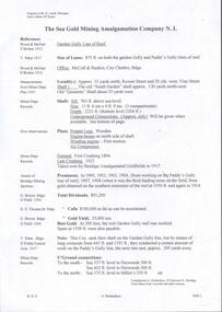
Carbon copy of notes, with typed copy of same, on The Sea Gold Mining Amalgamated Company N. L. on the Garden Gully Line of Reef. Notes include size of lease, office, locality of shaft, sill and depth of shaft, plant, first & last crushing, Prominence, call and dividends, gold yield, best gold and underground connections. Signed by A Richards. Written at the top of page: Original to Mr R Leach, Manager, Allan's Music . Notes prepared by Albert Richardson.document, gold, the sea gold mining amal coy n l, the sea gold mining amalgamated company n. l., notes on the sea gold mining amalgamated company n. l., mccoll & rankin, mines dept plan 1937, annals of bendigo mining sections, g brown bendigo goldfield 1936, wood & mcnair s'brokers 1912, v pabst bendigo goldfields central area 1917, mines dept records, a richardson -
 Bendigo Historical Society Inc.
Document - VICTORIA HILL - VISITOR PLANS FOR VICTORIA HILL
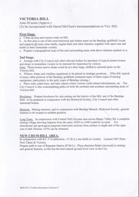
Handwritten carbon copy and typed copy of notes on 1st and 2nd stage plans for a tourist area on approx. 20 acres at Victoria Hill. First stage was to clean up the area, locate and sign post shafts, engine beds, etc and prepare a topographical map with these features on it. Second stage was to arrange for the purchase of typical miners homes and shops in the vicinity to be restored for inspection by visitors. Mining equipment to be placed in the area. Prepare brochures for sale. Set up a mining museum.Prepare an area near BCV 8 with direction finder to mining and general features, as this has the best natural ground level view in the City. Notes prepared by Albert Richardson.mine, gold, victoria hill, victoria hill, visitor plans for victoria hill, darrel mcclure, bendigo city council, bendigo historical society, central nell gwynne, caleb thomas, bcv 8, lazarus, old chum, new chum, victoria, repeater station (p. m. g.) -
 Bendigo Historical Society Inc.
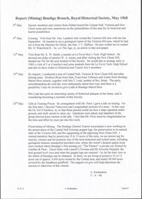
Document - MINING PLAN longitudinal section, Circa 1880's
Mining plan: Showing shafts and layout of Gibbs, Ballerstedt and wells, Humboldt Co., Great Central Victoria Co., Adventure and Advance (in two pieces)topic, mining, plans, gold mines bendigo, gibbs, ballerstedt, wells, humboldt co., great central victoria co., adventure and advance -
 Bendigo Historical Society Inc.
Document - MINING REPORTS - MINING REPORTS BY A RICHARDSON
Handwritten reports dated May 1968 by A. Richardson. On the 4th May visitors from Hobart toured the Central Nell, Victoria and New Chum Hill areas. Also on the 4th, a visit from Mr Geo Lambert who gave him a geological report of the Victoria Hill area. On the 13th May, a visit from Mr K W Smith who showed him slides of derelict W. A. mines. Also plans for the preservation of Mining in Bendigo at Victoria Hill and the preservation of the Central Nell Gwynne poppet legs.document, mining reports, mining reports by a richardson, mr geo lambert, hon j c balfour, mr n wakefield, mr k w smith, le fevre boy's tech high school, mrs f leak, mr perry, gt extended hustlers, central nell gwynne, the pioneer, gunther & party, lansell's fortuna, mt alvernia hospital, a richardson, devonshire mines, bendigo & district tourist association, mrs checcucci, mr jackman, mr greenway, r a c v, cl gerry, eureka extended, bendigo branch historical society -
 Bendigo Historical Society Inc.
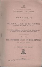
Book - MINING REPORTS - THE CONFIDENCE GROUP OF MINES BULLETIN NO 41
Light brown covered booklet 'Bulletins of the Geological Survey of Victoria issued by W Dickson, Secretary for Mines, Under the Authority of the Hon. S Barnes M L A Minister of Mines. No 41 The Confidence Group of Mines, Bendigo with Plans and Sections by H S Whitelaw, Field Geologist, dated 1918. Mines mentioned are: Confidence Extended Mine, Confidence Tribute Company and the Central Windmill Hill Mine. Mentioned in the report are crushings and gold yield, details of levels, names of leases along the reef. Extracts from Mine Manager's Half-yearly Reports, 1878-1915 of tons crushed and gold yield. Plans and sections of the Confidence Extended Mine on the Garden Gully Line of Reefs are: Plate I General Plan of All Levels, Plans of Levels Plate No II, Plans of Levels Plate No III, Transverse Section Plate No IV, Longitudinal Section Plate No V, and Central Windmill Hill Mine Transverse Section Plate No VI. Plates signed by H S Whitelaw 17 & 18/6/16 and 20/7/16. Booklet if part of the Albert Richardson Collection. book, bendigo, mining reports, mining reports, the confidence group of mines bulletin no 41, confidence extended mine, confidence tribute company, central windmill hill mine, department of mines, bulletins of the geological survey of victoria, w dickson, the hon s barnes, h s whitelaw, h j green, mr robert eddy, mr w h cundy, j foster, c j thompson -
 Bendigo Historical Society Inc.
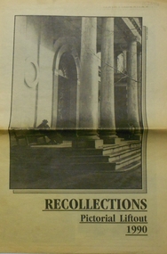
Newspaper - PETER ELLIS COLLECTION: RECOLLECTIONS PICTORIAL LIFTOUT
Historical lift out. Newspaper. Titled RECOLLECTIONS Pictorial Lift out 1990.1 looking down Mitchell St. from Railway Bridge. 2 Original railway station viewed from Mitchell St. bridge. 3 The great extended Hustlers mine. 4 1873 photo recently extended town hall with corn exchange at front left. 5 looking north westerly from city rec reserve at royal hustlers. 6 children play on mullock heap in front of a view of westerly quarter of Sandhurst. 7 Bank of Victoria, Mitchell St. left is Bendigo's original post office. 8 Looking down from what is now Rosalind Park. Shamrock Hotel can be seen on corner of Williamson St. and Pall Mall. This photo predates the construction of post office and law courts. 9 girl eating fairy floss. 10 4 kids on 1 horse in procession. 11 monkey and pedal car, a novelty attraction 1940's. 12 pony rides. 13 flying horses (ride). 14 processions past city hall. 15 Original ANZ bank corner Williamson St. & Pall Mall. 16 Chinese Dragons Bendigo Easter Fair 1940's. 17 City Hall viewed from Bull St. 18 City Hall original ceiling. 19 new town hall 1861. Mike Butcher, local historian. 21 Interior plan of city hall (ground floor) 22 circa 1920's 23 Tattered fragment original architect's drawing. 24 original assembly room. 25 Camp Hill PS Shamrock hotel without top story 27 shop with signage advertising Bushells, Bex and Swallow's Biscuits. 28 View from where fountain is now. 29 Hargreaves St. Looking south, now Hargreaves mall. Horse drawn water tank watering down road. 30 Central Deborah Gold mine poppet head. 31 Borough town hall, tram ways. 32 Original ANZ Bank corner Williamson St. and Pall Mall, demolished in mid 1960's. 33 Bush's store corner Williamson and Myer streets.34 Men on boat, don't know what or where. 35 Shearers. 36 men on a three wheeled bike. 37 4 Gold miners with shovels. 38 6pm closing, no trade Sundays, no women in main bar. 39 Peaceful scene Castlemaine 1940's Photographer Alan Doney. 40 Qantas Jet the City of Bendigo Tullamarine Airport. BCV-8 camera man & Advertiser photographer. 41 Ladies. 42 Tennis -> men and women (women in hats). 43 Sandhurst footy team. 44 Early school photos.bendigo, history, photographic history -
 Bendigo Historical Society Inc.
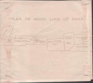
Map - NEW MOON COMPANY, NO LIABILITY - PLAN OF THE MOON LINE 1906
Plan of the Moon Line of Reef 1906. Plan shows the line of reef and the leases with the distance along the reef. The Bendigo - Inglewood railway line is also drawn in. Leases mentioned are: Nth Johnsons, Johnson's Reef,Princess Dagman, Golden Age, Johnson's Reef Extd, Golden Pyke, Constellation, McDuff, Great Northern, Virginia, Specimen Hill, New Hopeful, New Argus, Clarence, North Argus, Moon, South New Moon, New Moon, Suffolk Tribute, North New Moon, New Moon Consolidated, New Moon United, Adelaide New Moon, Bendigo New Moon, The New Moon Northern Blocks, Central New Moon, Rising Moon, Full Moon, The Moon, Gt Extd New Moon, V Rymer.map, bendigo, goldfields, new moon company, no liability, plan of the moon line 1906, a richardson, nth johnsons, johnson's reef, princess dagman, golden age, johnson's reef extd, golden pyke, constellation, mcduff, great northern, virginia, specimen hill, new hopeful, new argus, clarence, north argus, moon, south new moon, new moon, suffolk tribute, north new moon, new moon consolidated, new moon united, adelaide new moon, bendigo new moon, the new moon northern blocks, central new moon, rising moon, full moon, the moon, gt extd new moon, v rymer. bendigo - inglewood railway -
 City of Greater Bendigo - Civic Collection
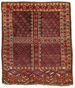
Textile - Yomut Turkmen Islamic Rug, c 1880
This rug was a gift and gesture of friendship from the local Muslim community to the City of Greater Bendigo. It was presented to Mayor, Cr Rod Fyffe on behalf of the people of Bendigo at a 2016 'Thank You Bendigo' dinner. In 2014 approval for a planning application from the Bendigo Islamic Association to build a community centre and mosque in East Bendigo prompted a series of public protests that captured widespread media attention. During this tumultuous period the Council identified the need for a community-wide plan to promote diversity and help address potentially divisive cultural issues. These events led to the COGB becoming the first local government area (LGA) formally accredited under Australia’s Welcoming Cities Standard. Community leaders emerged who wanted to show that the anti-mosque protesters did not reflect the views of the majority of Bendigo residents. The community lead ‘Believe in Bendigo’ movement gained momentum, and the Council and other local organisations joined forces to present a unified message that Bendigo residents do not tolerate racism. Muslims have made Central Victoria their home since the Goldrush, contributing to the community and the economy for the past 120 years. Traditional Islamic rugs, especially their patterns and motifs are intrinsically linked with the design of the Bendigo Mosque and Bendigo Islamic Community Centre providing important points of reference for the architects of the project. Typically, mosques are linked with specific cultural groups but not in the case of Bendigo where the Muslim community is made up of multi-ethnic groups. This meant the building's design was not fixed to a specific style or cultural iconography but instead needed to encompass many. The small local Muslim community selected a specific Australian architect because of their interest and knowledge of Islamic design and iconography gained through family collection of Islamic textiles. In thinking about the design of the mosque and community centre the architects wanted to acknowledge the role of Afghans in Australian history, especially tribal Afghans who helped build connections across the interior of Australia between First Nations communities, European settlers and Central Asian migrants. The gift of this Turkmen rugto the Bendigo community thus symbolises collaborative partnerships across faith and cultural groups based on friendship and mutual benefit. A Turkman rug was specifically chosen as it is the pinnacle of nomadic arts of the Islamic world. It was also important to the architects and the local Muslim community that the gift was a female artistic product as it was mainly a female Muslim architecture team that designed the mosque in Bendigo and there was a desire to select something that celebrated female artistry. This hand-woven rug is an engsi, made for a woman in preparation for marriage. Design work and weaving is a shared experience, between many generations of women and each rug hold the personal story of the woman it is made for and her family and thus holds deep symbolic meaning. There are often songs and poetry that are recited as the rug is made – helping the makers to memorisze the mathematical structure of the design. An engsi is put on the doorway to a yurt as part of a wedding ceremony. During the ceremony the groom turns the engsii upside down to check the quality of the rug makers weaving skills. The nomadic lifestyle of Yomut Turkman tribes determines the size of the rug as the loom can’t be carried. Its size is also restricted by the dimensions of the doorway of the yurt. This rug is dated as c 1880 because of the types of patterns used, the use of natural dyes (synthetic dyes were introduced to the area in 1890s) and with the smoother weaving on the back indicating the quality of craftsmanship dating to this time period. The Yomut engsi rug was made in Turkmenistan c1880 by Yomut Turkmen Tribes people and is designed to fit over the doorway of a yurt during a wedding ceremony. The main field motif is related to Turkoman jewelery design. The women and girls of the tribe spin the wool and design and weave the rugs. The men shear the sheep, dye the wool and clip the rug after it has been woven. The word “Turkoman” is thought to have been derived from Turk-iman, meaning the first nomadic Turkic tribes that began to follow Islam. Dyes used are natural including orange from madder root. bendigo mosque, bendigo islamic association, city of greater bendigo community partnerships, city of greater bendigo community groups -
 Bendigo Historical Society Inc.
Document - MINING REPORTS - REPORT ON MINES DEC. 1ST 1966
Handwritten notes, with typed copy, listing 14 reports on mines and locality plans. If it was decided to have postcards of some famous mines, there is a suggestion of how they could be set out. Also a paragraph thanking the Mine's Dep't, Miss Parry and Mr. E. Jackman for work they have done.document, gold, mining reports, mining reports, report on mines dec 1st 1966, carlisle united, central nell gwynne, central red white and blue, fortuna hustlers, garden gully united, gt extended hustlers, lady barkly, new argus, new chum railway, new chum syncline, new moon, new red white and blue consolidated, south new moon, united hustlers and redan, mine's dep't, miss parry, mr e jackman -
 Bendigo Historical Society Inc.
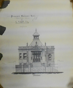
Document - MARKS COLLECTION: PLAN OF FORTUNA VILLA ENTRANCE HALL
Copy of plan: Written on top: Proposed Entrance Hall, Fortuna Villa, for G. Lansell, Esq. Plan shows section of building, central staircase leading to front doors, double doors with side panels. Turret, with skylights on top. Signed on top: 'W. Beebe, Architect'.buildings, house, fortuna villa -
 Bendigo Historical Society Inc.
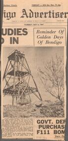
Newspaper - CENTRAL NELL GWYNNE MINE - NEWSPAPER ARTICLE ON CENTRAL NELL GWYNNE MINE
Newspaper article from the Bendigo Advertiser, dated Thursday, May 4, 1967 on the Central Nell Gwynne Mine. It has a picture of the poppet legs of the Central Nell Gwynne Mine with an old gold digger's dish in the foreground and a bush on the right. The article mentions tourists ask to see a gold mine, but none are working. The Bendigo branch of the National Trust has asked the council (who are the trustees of this once famous gold mine) whether it has any plans for the development of the site of this mine and the city engineer to make a report.newspaper, bendigo advertiser, central nell gwynne mine, central nell gwynne mine, newspaper article on central nell gwynne mine, bendigo advertiser, bendigo city council, bendigo branch of the national trust -
 Eltham District Historical Society Inc
Document - Property Binder, 616 Main Road, Eltham; Plum Cottage
Plum Cottage is covered by Heritage Overelay HO256 in the Nillumbuk Planning Scheme This two-lot land holding was created as a subdivision and sold to Charles Stuart McNeil by May 1955. Sometime in the period 1955-1960, the builder-designer, John Harcourt had created a pise house on the site, straddling the two subdivision lots. The designer, John M. Harcourt was a pioneer builder in pise-de-terre and mudbrick in the Eltham Shire, Eltham being synonymous with alternative lifestyles and building practises until the onset of suburbia in the late 20th and early 21st centuries. This hipped-roof house is set high above Main Road on a V-shape plan characteristic of the Arts & Crafts style, with rammed earth or pise walls, timber joinery and a cement tiled roof. The V shape plan was used by important English and Eltham Arts & Crafts designers. The use of natural materials such as stone and timber construction is an essential part of the Arts & Crafts style and Harcourt’s work. So too is the application of the style on both the exterior and interior of the house as a holistic concept. The house adjoins the Lim Joon adobe house built and designed by Alistair Knox in the same era (HO119), thus forming a distinctive pair, both using an uncommon plan form. This house was identified in the Shire of Shire of Eltham Heritage 1992 as contributory to the Eltham Gateway Conservation Area, then proposed as an urban conservation area (now Heritage Overlay Area). Land Ownership Emily Jane Smith of 12 Woodside Street Fitzroy owned Crown Allotments 1 & 2 Sections 14, 27 by August 1918, selling to William Henry Smith of 12 Woodside Street, Nth Fitzroy May 1921. (John) James Isherwood of Main Road, Eltham owned the property by 1928 (the year of his death) with the beneficiary of his estate and next owner of this site being his widow, Minnie Maria Isherwood of Cemetery Road, Eltham. His holding in Main Road included parts of what was described in rate records as allotments1 & 2 Section E6. In the late 1930s, early 1940s her son Alfred John Isherwood was also rated for the land around this site, with the rated nett annual value varying between £2 and £5. Alfred Isherwood also lived at Main Road, Eltham with his wife Ellen: her early death at the age of 24 was reported in the Argus of 1923. Part of the Isherwood land was divided off and sold to Charles Stuart McNeil by May1955. Sometime in the period 1955-1960, the builder-designer, John Harcourt had created a pise house on the site, straddling the two subdivision lots. The house is visible on an aerial photograph from 1960s. Reputedly the house was called Plum Cottage and erected for Harcourt’s mother-in-law. A garage was added in 1959. Charles McNeil died in1971 aged 87: he was the son of Don McNeil and Margaret Arkell. Available rate records from the construction era start in the of the 1970s (1972-3) and list Mr H.C. & M/S A.V. Charity at 616 Main Road Eltham of this property with a nett annual value of $740. More recent valuer's data describes the property as lots 1 & 2 LP25668, located in the Central Riding of Eltham Shire, owned by Ann Valerie Charity and later, in 1990, by the Chincarini family. Building Description This hipped roof 11 .5 square house is set high above Main Road on a characteristic-shape plan and has rammed earth or pise walls, timber joinery and a cement tiled roof. The V-shape plan was used by Important designers such as C.F.A. Voysey (UK) who interpreted medieval domestic architecture as part of the Arts & Crafts style of the late 19th and early 20th centuries. The pise walls are covered with a textured render while the cement roofing tiles are also seen in the Harcourt Hill examples. Reputedly the ceiling joists are of a deep section and span long lengths with no need for hanging beams in the roof space. The ceilings are low and panelled in main rooms with apparently Caneite soft board infill panels between the exposed ceiling beams. These are painted white but may have been stained at one time. The focus of the house is the large living area with its vast random stone fireplace. Significance Plum Cottage is significant to the locality of Eltham because: Historically: • Plum Cottage is closely associated with the important historical theme of earth construction evident in Eltham and elsewhere in the Shire since theear1y Arts & Crafts inspired creations at Penleigh Boyd's The Robins (1912, HO101) and those at Montsalvat (1934-, HO82) but more prominent from the Second War period when earth building in Eltham was promoted in national periodicals as an alternative building method that avoided the building materials shortages of that era; • The choice of the earth building technique also expresses the theme of refuge or alternative living, synonymous with Eltham in the early to mid 20th century; • as a good example of domestic architecture from John Harcourt who was the first major post Second War figure in an important phase of Eltham’s earth building development, using his characteristic Old English or Arts& Crafts style that relies in this case on the pise wall construction, pitched roof forms, exposed ceiling joists, half timbering, random stonework, and panelled internal wall finishes. Architecturally: • Plum Cottage's pise wall construction is uncommon among the early earth-walled structures in the Shire, that are mainly of adobe or mud brick, and as a building material is uncommon among the Shire’s suburban dwellings generally which are clad typically with either fired clay bricks or timber boarding. Aesthetically: • Plum Cottage is a good and well preserved example of a modern Old English or Arts & Crafts style earth-walled building in the Shire • For the proximity of the significant Lim Joon adobe house designed by Alistair Knox adjoining to the north, providing a distinctive earth wall house pair, with uncommon plan forms. Reference Heritage Assessment of Plum Cottage, 616 Main Road, Eltham; Graeme Butler & Associates 2010main road, eltham, property, houses, (john) james isherwood, alfred john isherwood, ann valerie charity, arts and crafts style, charles stuart mcneil, chincarini family, eltham gateway zone, emily jane smith, h.c. charity, heritage assessment, john harcourt, john m. harcourt, lim joon house, main road eltham, minnie maria isherwood, pise construction, plum cottage -
 Bendigo Historical Society Inc.
Document - NEW CHUM & VICTORIA LINES OF REEF - NOTES ON VICTORIA HILL FOR TOURIST ATTRACTION
... Handwritten notes outlining a plan for Victoria Hill...DOCUMENT Gold New Chum & Victoria Lines of Reef Central ...Handwritten notes outlining a plan for Victoria Hill, Central Nell Gwynne and New Chum Hill to be the focal position for a tourist attraction. Outlines steps to be taken to do the work and a mining museum at the Central Nell Gwynne. On the back of the page is a sketch of Victoria & New Chum Hills. On the plan is the Battery, Rae, Rae's House, Rae's Open Cut, Wittscheibe, Midway, Victoria Quartz, Lansell's 180 Shaft and the Recreation Reserve.document, gold, new chum & victoria lines of reef, central nell gwynne, new chum hill, bendigo and district tourist development association, victoria hill, lansell's big 180, victoria quartz, rae's open cut -
 Bendigo Historical Society Inc.
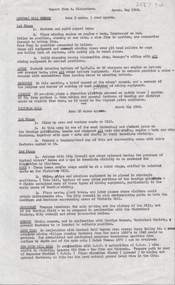
Map - MINING REPORTS - PLAN OF CHEWTON GOLDFIELD 1937
Plan of the Chewton Goldfield with Scale Measurement in chains. Plan shows the township of Chewton with the reefs and leases, the railway line and the Main Castlemaine - Melbourne Road. Also, the Eureka Vineyard. Issued by The Stock Exchange of Melbourne, April 1937. Leases named are: Central Wattle Gully, Wattle Gully United, Wattle Gully Extended, South Wattle Gully, Golden Wattle, Chewton, White Horse, Wattle Gully, North Wattle Gully, North Chewton, Upper Barkly, Post Office Hill, Misima United, Argus Hill, Chapmans, Chewton Prospecting Co, Fiji Gold & Gold Mines of Fiji and Nimrod. Stamp in the top right corner: Edward Dyason & Co. - Queen St. Melbourne. Sharebrokers.map, mining reports, plan of chewton goldfield, edward dyason & co, the stock exchange of melbourne, central wattle gully, wattle gully united, wattle gully extended, south wattle gully, golden wattle, chewton, white horse, wattle gully, north wattle gully, north chewton, upper barkly, post office hill, misima united, argus hill, chapmans, chewton prospecting co, fiji gold & gold mines of fiji, nimrod -
 Bendigo Historical Society Inc.
Postcard - BENDIGO POSTCARDS x 5
Five sepia postcards of Bendigo - St. Paul's Church, Bendigo; Queen's Reserve, Bendigo; St. Andrew's Presbyterian Church and School, Bendigo; The Orphanage, Bendigo; and Conservatory Gardens, Bendigo. 'C & L Series' and 'Semco Series', Bendigo. Early 1900's. Unused, and no writing on the reverse of the postcards. May have been connected with the Waterworth family. St. Paul's Church: St Paul's Cathedral, Bendigo was built in stages. The nave was built in 1868, the tower in 1872-73 and the transepts and sanctuary in 1926-27. Robert Love was the architect, although the final stage was supervised by architects Gawler and Drummond. Cathedral status was transferred from the original cathedral All Saints to St Paul's in 1981. The Gothic style cathedral is constructed of red brick with stone dressings. It has a simple cruciform plan comprising a six bay nave, transepts and sanctuary. A tall tower centrally located at the west end dominates the exterior. The peal of eight bells was cast by Meares and Co of London and installed in 1873. The interior features elaborately cusped roof principals; an organ by Alfred Fuller built in 1883 with a console and pipes added later from St Andrew's Cathedral, Sydney; and notable stained glass by Ferguson, Urie and Lyon. St Paul's Rectory was built in 1885 to a design by the architect W C Vahland. The Parish Office and Hall was built as a Sunday School in 1898 to a design by F W Lehmann. Queen's Reserve: Now known as part of the Bendigo Botanic Gardens, Rosalind Park, Pall Mall. In 1851, the gold rush transformed the area and eventually the mullock heaps became the most prominent public park in Bendigo. Rosalind Park was added to the Victorian Heritage Register in 2000 for its historic, archaeological, aesthetic, scientific (botanical) and architectural significance to the state of Victoria. The statue of Queen Victoria dates to 1903. St. Andrew's Presbyterian Church: Opened in 1859 as part of the Presbyterian Church, St. Andrew's. Union of the Presbyterian, Methodist and Congregational Churches in 1977 saw this church join the Uniting Church. Located in Myers Street, Bendigo. The Orphanage: The Convent of the Good Shepherd, Bendigo was established in 1905. It was established at the request of the Bishop to cater for children in the diocese of Bendigo (although it housed children from other areas as well). It was also known as St Aidan’s Orphanage, and was the only Good Shepherd Convent in Australia to care for boys. The section named St Aidan’s accommodated girls aged up to around 16 years, as well as boys aged up to around 11. Maryfields housed girls and women aged from around 15 years. The Convent ceased to operate as a residential facility for children in 1981. A number of women with disabilities remained at the Convent until it closed in 1984. Conservatory Gardens: Now known as part of the Bendigo Botanic Gardens, Rosalind Park, Pall Mall. In 1851, the gold rush transformed the area and eventually the mullock heaps became the most prominent public park in Bendigo. Rosalind Park was added to the Victorian Heritage Register in 2000 for its historic, archaeological, aesthetic, scientific (botanical) and architectural significance to the state of Victoria. The Conservatory Gardens feature an ornate 19th century Conservatory building, erected in 1897 - this was the last building of its type in a public park in Victoria. bendigo, gardens, buildings, chinese, church -
 Bendigo Historical Society Inc.
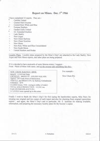
Document - VICTORIA HILL - WORK STAGES FOR THE CENTRAL NELL GWYNNE AND VICTORIA HILL
... Two typed copies (a & b) of restoration plans... typed copies (a & b) of restoration plans for the Central Nell ...Two typed copies (a & b) of restoration plans for the Central Nell Gwynne and Victoria Hill areas. Notes list first and second stages for the work to be carried out. Notes dated ''about May 1968''. New Chum Hill Area is also mentioned.document, gold, victoria hill, work stages for the central nell gwynne, victoria hill and new chum hill areas, city council, historical society bendigo branch, caleb thomas 1879, b c v 8, lazarus old chum, new chum and victoria, p m g repeater station -
 Bendigo Historical Society Inc.
Document - VICTORIA HILL - VICTORIA HILL AND NEW CHUM HILL
Typed notes on Victoria Hill and New Chum Hill. Notes give location, value of gold and plans for a mining museum.document, gold, victoria hill, victoria hill and new chum hill, john neil macartney, the age, the australasian, bendigo goldfields registry 1871, victoria reef quartz mine, north old chum, victoria consols, new chum and victoria, pioneer, lansell 222 mine, lazarus, barnet lazarus, mt. alvernia hospital, fortuna villa, george lansell, a. h. q. survey regiment, central red white and blue, hudsons, burrowes & sterry, b c v channel 8, bendigo and district tourist association, section 14 of the lands act 1958, mr a r richardson, cr t r flood, tourist association -
 Bendigo Historical Society Inc.
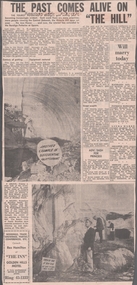
Newspaper - VICTORIA HILL - VICTORIA HILL NEWSPAPER ARTICLE
Two copies of newspaper articles titled ''The Past Comes Alive on 'The Hill'' from the Bendigo Advertiser dated 3/7/1971. Some history, a guided tour by two busloads of students and some plans are mentioned in the article. There are also two photos in the article. In one photo three Rotarians of Bendigo South, Mr. Vic Wodetski, Mr. Jack Bright and Mr. A. E. Richardson are inspecting some of the concentric rings of iron oxide and the quartz spur running through the centre of the outcrop on Victoria Hill. In the other photo Mr. jack Bright is looking at the natural curves of colour in the stone of Victoria Hill.newspaper, bendigo advertiser, victoria hill, victoria hill newspaper article, central deborah, victoria hill open cut, joss house, bendigo potteries, mr a e richardson, bendigo historical society, mr j hattam, reservoir high school, mr w j derham, rotary club of bendigo south, bendigo and district tourist association, victoria quartz mine, george lansell's big 180, theodore ballerstedt, goldmines hotel -
 The Beechworth Burke Museum
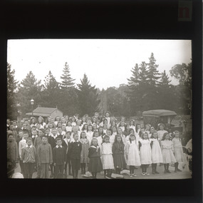
Photograph - Lantern Slide, c1900
This glass slide depicts a group of school children standing in Queen Victoria Park (previously Beechworth Botanic Gardens), circa 1900. Queen Victoria Park was first secured in 1858 by the Beechworth Council with the assistance of the Central Board of Health (CBH). The CBH was a firm believer in the socially beneficial effects of parks and other recreation areas which is why they aided the council in securing the parkland. the council held a local competition for the design of the park and decided on a plan called "Better late than never" by Hungarian nobleman, J.A. Rochlitz. The first non-native trees were planted in 1861 and have since been heritage listed on the National Trust's register of significant trees. There are nine trees located in Queen Victoria Park that are currently on the National Trust's register. These are the Loblolly Pine, Italian Cypress, Shore Pine, and the Big Cone Pine. These trees hold significance as they date back to 1875 and show rare and localised examples of these types of species which are not seen in many other places in Victoria. The trees in the background of the glass slide depict a species of the pine tree and may be some of the trees still standing in Queen Victoria Park today.This glass slide captures social and historical significance as it not only captures a moment in time of these school children, but it also shows environmental significance for the heritage trees depicted in the background.burke museum, beechworth, lantern slide, slide, glass slide, plate, burke museum collection, photograph, monochrome, queen victoria park, indigo shire, school, j.a. rochlitz, beechworth council -
 Bendigo Historical Society Inc.
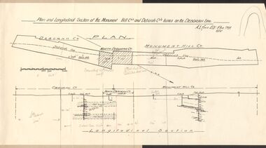
Document - MCCOLL, RANKIN AND STANISTREET COLLECTION: MONUMENT HILL CO., DEBORAH CO. LEASE ON DEBORAH LINE
Plan of Monument Hill Co., and Deborah Co. leases on the Deborah line. Black line drawing, showing longitudinal section. 'Deborah shaft to Nth Deborah 1100 ft ' noted in pencil . 'Nth Deborah shaft to Central Deb shaft 2000ft' in pencil. Other pencil notation on map re distance of leases. Map is attached to back page of booklet, rest of information missing.business, mining, mccoll rankin & stanistreet -
 Bendigo Historical Society Inc.
Map - PLAN GENERAL SURVEY MALMSBURY PORCUPINE INN, FOREST CREEK TO GOLDEN POINT. ALEXANDRA RANGE 1853
Colour Copy of Plan of the General Survey from the Town of Malmsbury to the Porcupine Inn, from the sources of Forest Creek to Golden Point, shewing (sic) the Alexandrian Range also Sawpit Gully Bendigo and Bullock Creeks. Handwritten note under the title a follows '' Forwarded to the Colonial Secretary with my letter No A 53/105 dated 30th March 1853 for transmission to the Geological Surveyor. R Hoddle Surveyor General. ' Stamped by Department of Mines Victoria with record#123 in Top right Hand corner. Also contains a catalogue number 2053/M/2. Part of the Contents of a DVD entitled 'Mapping Great Change' - Archival Maps, produced to support an exhibition in the Post Office Gallery Bendigo. A description of the Map, its history and implications for both historical and future discussions is contained in an Essay 'Mapping Great Changes' : The landscape of central Victoria by Gerry Gill.R. Hoddlemap, bendigo, country lands -
 Bendigo Historical Society Inc.
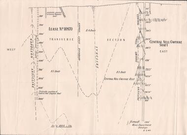
Plan - Mining Lease No. 10970, April, 2014
One page plan of Lease No. 10970, showing Napoleon Anticline and Central Nell Gwynne Shaft. Prepared by J. Caldwell, Mines Department Bendigo 6.2.1940.goldmining, quartz, mining, central nell gwynne gold mine, napoleon reef -
 Bendigo Historical Society Inc.
Document - HERCULES AND ENERGETIC MINES - NOTES ON THE HERCULES AND ENERGETIC MINES
Four typed copies of notes on the Hercules and Energetic Mines. Notes include Location, depth of shafts, plant and machinery, Early History and Prominence. Reference: Mines Dept Special Edition Australian Mining Standard 1.6.1899, Mines Dept Booklet Bendigo Goldfield 1936, Mines Dept Annual and Quarterly Reports, Annals of Bendigo Mining Sections 1876 - 1921, A Richardson, The Bendigo Goldfield Registry J N Macartney 1.3.1871, Mines Dept Bulletin No 30 h Herman 1914, Bendigo Amalgamated Goldfields Coy Financial Reports 1920. There are three typed copies, also the original handwritten notes.mine, gold, hercules and energetic mines, notes on the hercules and energetic mines, the north energetic, the victoria pilot, plan of leases of 1870, bendigo amalgamated goldfields company, sheepshead line, central blue, big blue, mines dept special edition australian mining standard 1.6.1899, mines dept booklet bendigo goldfield 1936, annals of bendigo mining sections 1876 - 1921, a richardson -
Clunes Museum
Map, 1890
Features location of Club Hotel, Union Bank, Engine rooms, Port Phillip Hotel, Pyrites furnace, Battery, Office, Smith Shop,Surface Tramway to BatteryPhotocopy of map/plan of Dixon's New North Clunes, Central Clunes Co. and South Clunes utd showing various shafts and pre-emptive rights. Scale 1 inch = 100 feetOn front in red ink; "drawn in 1890"mine shafts, hotels, plans