Showing 941 items matching "channels"
-
 Lakes Entrance Historical Society
Postcard - Reeves Channel, 1910 c
Black and white postcard showing view of Reeves channel looking west toward Metung west end of Rigby and Fraser Islands mouth of Maringa creek lower right with neat mill workers cottages on flat Lakes Entrance Victoriawaterways -
 Lakes Entrance Historical Society
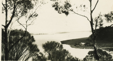
Photograph - Reeves Channel, 1915c
Original in possession of descendant of Arthur Seagrove, teacher at Johnsonville School c1920.Black and white photograph of Reeves Channel, Gippsland Lakes, showing a launch in the Narrows below Jemmy's Point, Rigby Island and a distant view of Fraser Island and Flannagan Island opposite the steep cliffs of the mainland shore. Lakes Entrance Victoria'To Rit with love from Arthur' on backislands, waterways, topography -
 Melbourne Legacy
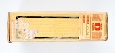
Film, Legacy Week Appeal 1974, 1974
Depicts activities during Legacy Week Appeal 1974. Channel 10 appeal-a-thon with Keith Stackpole, a famous cricketer.A record of a celebrity doing an appeal for Legacy Week.White cardboard box with Scotch logo containing a 2 inch wide video tape on a spool, of Keith Stackpole for Legacy Week in 1974.Box, written in black texta Legacy Week Appeal 1974, Keith Stackpole 10 sec. Video Tape no 03-124, Spool, tape no 03-124. legacy week, legacy promotion -
 Forests Commission Retired Personnel Association (FCRPA)
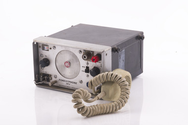
Forest Phone, Amalgamated Wireless Australasia (AWA), AWA FP-1
In the mid 1960s, Amalgamated Wireless Australasia (AWA) was asked to design a solid-state replacement for the PYE TRP-1 in collaboration with the FCV. The new transceiver was to be more powerful than the TRP-1, with an output power of about 10-12W (compared to 1.5-2W). The set also had to be capable of being used as a walkie-talkie, as well as being suitable for use in a vehicle The FP-1 is a single channel radio that has a crystal for each channel, and an IF frequency of 45 5khz. The receive crystal is 455khz higher than the transmit crystal. It is completely transistorised, and uses AWA and RCA brand transistors. A later version was called the FP5 and had five channels. Introduced to the FCV in the mid 1960sRadio Receiver Forest Phone FP-1 radios, forests commission victoria (fcv) -
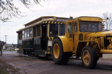
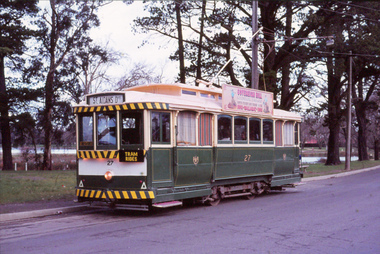 Ballarat Tramway Museum
Photograph - Digital image, John Theodore, late 1970's or early 1980's
Yields information about the BTPS and tram 27 at Carlton St after the kerb and channel has been constructed at this location.Digital images scanned from 35mm slides of BTPS No. 27 at Carlton St late 1970's or early 1980's after the kerb and channel has been constructed at the terminus. The Sovereign Hill advert has been fitted to the tram.trams, tramways, btps, carlton st, tram 27 -
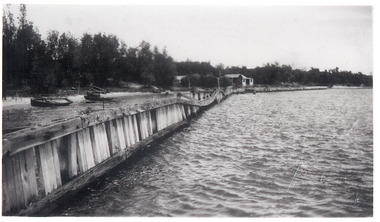 Lakes Entrance Historical Society
Photograph - Hopetoun Channel, 1946
Black and white photograph showing walings along shoreline west of entrance piers and Schnapper Cotttage further along. Dense vegetation on dunes, several small boats on beach behind walings, Hopetoun channel right foreground. Lakes Entrance Victoriahouses, waterfront -
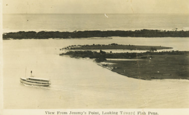 Lakes Entrance Historical Society
Postcard - S.S. Gippsland, 1910 c
Note on back Happy Christmas to all from Aunt AliceBlack and white postcard showing SS Gippsland in Reeves Channel below Jemmys Point heading towards town East end of Rigby and Snake Island shown Fish pens visible along Hopeton Channelk shoreline Lakes Entrance VictoriaView from Jemmys Point towards fish pensships and shipping, waterways, correspondence -
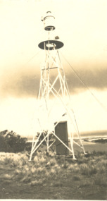 Lakes Entrance Historical Society
Photograph - Jemmys Point Light Lakes Entrance, 1926
Black and white photograph of light on Jemmys Point Lakes Entrance. Plus five other photos - .2 photo of Bullock Island and the entrance, .3 Bullock Island Footbridge, .4 Rigby and Snake Islands, .5 Rigby Island Reeves Channelnavigation, waterways, gippsland lakes -
 Lakes Entrance Historical Society
Photograph - Lakes Entrance, Gippsland Ports, 2006 c
Second copyColour aerial photograph of entrance from Bass Strait to Gippsland Lakes including Bullock Island Reeves Channel Rigby Island houses on Kalimna Hill and Princes Highway winding down Jemmys Point hill into township of Lakes Entrance Victoriaaerial photograph, ocean, waterways -
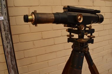 Tatura Irrigation & Wartime Camps Museum
Dumpy Level, Dumpty Level, 1920
Used by Mr. Craven to survey agricultural land in the Goulburn Valley for the purposes of setting out farm irrigation channels and check banksStanlley Dumpy Level on tripod, complete with carrying case and sixteen foot telescopic staffPatent Stanlley, Great Turnside, Holborn, London 11182surveying, irrigation, terrestrial -
 Tatura Irrigation & Wartime Camps Museum
Video Tape, Japanese Ex Internees
Excerpts of news broadcasts from Channel 6 Shepparton on occasion of revisit of Japanese ex internees. Visit organised by Jim Sullivanblack case vhsJapanese Ex Internees revisit camp 4 1993jim sullivan, japanese ex internees, camp 4, channel 6 shepparton -
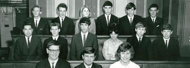 NMIT (Northern Melbourne Institute of TAFE)
Photograph: PTS students 1962
Preston Technical School Form 4 students attend the Channel 7 Parliament of Youth TV show. TV show included included debates between schools. (Speakers for the PTS case in front row and Alan Phillips, 2nd row, 1st on right).students, nmit, preston techinical school -
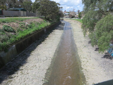 Ballarat Heritage Services
Photograph - Photograph - Colour, Clare Gervasoni, Yarrowee Creek after days of heavy rain, 2016, 17/09/2016
A number of photographs of the Yarrowee River after days of heavy rain. Two and three day previously the water reached the edges of the channel and was flowing very fast. The photographs were taken from and around the Hill Street Bridge near the Sunnyside Woollen Mills.yarrowee creek, yarrowee river, bridge, chanel, hill street, ballarat east -
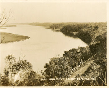 Lakes Entrance Historical Society
Postcard - Reeves Channel, Valentine Series, 1930c
Black and white small format postcard of Reeves Channel Gippsland Lakes, taken from Jemmys Point. It shows a glimpse of the Princes Highway, the steep shoreline of the mainland opposite Rigby Island with Fraser Island and Flannagan Island in distance. Lakes Entrance VictoriaKalimna Cove Lakes Entranceislands, waterways, topography -
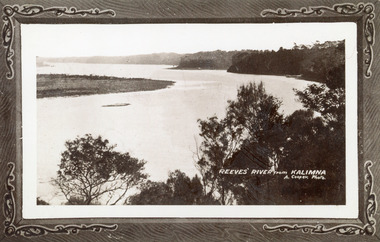 Lakes Entrance Historical Society
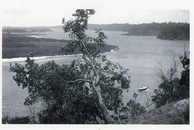
Photograph - Reeves River, 1910c
Also another copy print 8 x 13, both printed as though framedBlack and white photograph of Reeves Channel, Gippsland Lakes. It shows Rigby Island opposite the steep cliffs of mainland shore. Small island off Rigby was known as the Doughboy. Taken from Jemmys Point, natural vegetation in foreground. Lakes Entrance VictoriaReeves River from Kalimnaislands, waterways, topography -
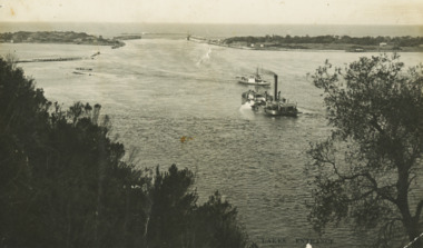 Lakes Entrance Historical Society
Postcard - Dredge Pioneer, Segerberg and Bulmer, 1910 c
Message on back Arrived safe 25th have a good time hoping you are well from FCG Addressed to Mrs FC Gason, Jessops Hill, Lower NicholsonBlack and white postcard showing dredge Pioneer working below Jemmys Point facing entrance rock groynes on west of Bullock Island calm entrance in distance steamer JCD heading across Reeves Channel after leaving Lakes Entrance VictoriaLakes Entrance waterways, dredges, correspondence -
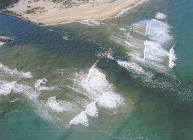 Lakes Entrance Historical Society
Photograph - Boat Harbour, Gippsland Ports, dredge April Hamer Lakes Entrance, 2006
Colour aerial photograph of the Entrance from Bass Strait to the Gippsland Lakes showing rock entrance groynes, surf on beach, dredge April Hamer working in the channel Lakes Entrance Victoria. Also another copy size 15 x 19.5 cmwaterways, topography, beaches, ocean -
 Bendigo Historical Society Inc.
Photograph - Historical Society Field Trip to the Springs at Sedgwick, Abt 2009
The Phil Wilkin Collection contains a series of 11 Items. The related items can be found by clicking on the reference link below. The following history of the Young family and their descendants who lived at the Springs is provided by Phil Wilkin. His Great Grandparents were Frances Young and August Wirth. Phil has also provided notes on the Wilkin Family and some history of the gold mining in Sedgwick. Frances Young's parents Joseph and Margaret Young owned the property called "The Old Place, Preston Vale or Wellington Flat" at Sedgwick near the Springs. Joseph Young owned and Managed the Standard Brewery which was located at Campbells Creek during the late 1800’s early 1900’s. Joseph and Margaret are buried in the Harcourt cemetery. In 1880 August Wirth lived at Mosquito Creek (Lake Eppalock, Victoria) when he married Frances Young. In 1902 they moved to part of Joseph Young's property. They milked cows and sold cattle for a living. One of their children Charles Wirth (Phil Wilkin's Grandfather) bought the land in 1935 after his parents had died. Charles Wirth was a councillor and also was president of the Shire of Strathfieldsaye. The "Old Place" was part of the property owned by members of the family. The old house at the Springs was burnt out by bushfire in January 1944 and much of the stonework was later vandalized by campers. The original Coliban Water Works were designed in 1863 by the Irish engineer Joseph Brady. The system included 70 kilometres of open water channels, aqueducts, syphons and tunnels to carry water (by gravity) from the Coliban River at Malmsbury, north to Castlemaine and Bendigo. Sedgwick is a locality in Central Victoria, Australia. It is located in the City of Greater Bendigo. Facilities include a public hall that opened in 1958 and CFA Rural fire station. It was named Upper Emu Creek until 1901 when it was renamed as Sedgwick after British geologist Adam Sedgwick.Twenty nine photos taken on a field trip by the Bendigo Historical Society to "The Springs" on the main Coliban water channel from Malmsbury to the Sandhurst Reservoir in Bendigo. The water race descends through a concrete chute, and continues sharply around the contour of the hills. Once it descended into a syphon across the gully. The are 182 photos in this series and can be found at 8683.1 to 8683.11. The series also includes photos of the surrounding farming land and the remains of an old house. There are also some notes on the pioneers of the district.history, bendigo, coliban water, joseph brady, irrigation, the springs, sedgwick -
 Bendigo Historical Society Inc.
Photograph - Historical Society Field Trip to the Springs at Sedgwick, Abt 2009
The Phil Wilkin Collection contains a series of 11 Items. The related items can be found by clicking on the reference link below. The following history of the Young family and their descendants who lived at the Springs is provided by Phil Wilkin. His Great Grandparents were Frances Young and August Wirth. Phil has also provided notes on the Wilkin Family and some history of the gold mining in Sedgwick. Frances Young's parents Joseph and Margaret Young owned the property called "The Old Place, Preston Vale or Wellington Flat" at Sedgwick near the Springs. Joseph Young owned and Managed the Standard Brewery which was located at Campbells Creek during the late 1800’s early 1900’s. Joseph and Margaret are buried in the Harcourt cemetery. In 1880 August Wirth lived at Mosquito Creek (Lake Eppalock, Victoria) when he married Frances Young. In 1902 they moved to part of Joseph Young's property. They milked cows and sold cattle for a living. One of their children Charles Wirth (Phil Wilkin's Grandfather) bought the land in 1935 after his parents had died. Charles Wirth was a councillor and also was president of the Shire of Strathfieldsaye. The "Old Place" was part of the property owned by members of the family. The old house at the Springs was burnt out by bushfire in January 1944 and much of the stonework was later vandalized by campers. The original Coliban Water Works were designed in 1863 by the Irish engineer Joseph Brady. The system included 70 kilometres of open water channels, aqueducts, syphons and tunnels to carry water (by gravity) from the Coliban River at Malmsbury, north to Castlemaine and Bendigo. Sedgwick is a locality in Central Victoria, Australia. It is located in the City of Greater Bendigo. Facilities include a public hall that opened in 1958 and CFA Rural fire station. It was named Upper Emu Creek until 1901 when it was renamed as Sedgwick after British geologist Adam Sedgwick.Twenty five photos taken on a field trip by the Bendigo Historical Society to "The Springs" on the main Coliban water channel from Malmsbury to the Sandhurst Reservoir in Bendigo. The water race descends through a concrete chute, and continues sharply around the contour of the hills. Once it descended into a syphon across the gully. The are 182 photos in this series and can be found at 8683.1 to 8683.11. The series also includes photos of the surrounding farming land and the remains of an old house. There are also some notes on the pioneers of the district.history, bendigo, coliban water, joseph brady, irrigation, the springs, sedgwick -
 Bendigo Historical Society Inc.
Photograph - Historical Society Field Trip to the Springs at Sedgwick, Abt 2009
The Phil Wilkin Collection contains a series of 11 Items. The related items can be found by clicking on the reference link below. The following history of the Young family and their descendants who lived at the Springs is provided by Phil Wilkin. His Great Grandparents were Frances Young and August Wirth. Phil has also provided notes on the Wilkin Family and some history of the gold mining in Sedgwick. Frances Young's parents Joseph and Margaret Young owned the property called "The Old Place, Preston Vale or Wellington Flat" at Sedgwick near the Springs. Joseph Young owned and Managed the Standard Brewery which was located at Campbells Creek during the late 1800’s early 1900’s. Joseph and Margaret are buried in the Harcourt cemetery. In 1880 August Wirth lived at Mosquito Creek (Lake Eppalock, Victoria) when he married Frances Young. In 1902 they moved to part of Joseph Young's property. They milked cows and sold cattle for a living. One of their children Charles Wirth (Phil Wilkin's Grandfather) bought the land in 1935 after his parents had died. Charles Wirth was a councillor and also was president of the Shire of Strathfieldsaye. The "Old Place" was part of the property owned by members of the family. The old house at the Springs was burnt out by bushfire in January 1944 and much of the stonework was later vandalized by campers. The original Coliban Water Works were designed in 1863 by the Irish engineer Joseph Brady. The system included 70 kilometres of open water channels, aqueducts, syphons and tunnels to carry water (by gravity) from the Coliban River at Malmsbury, north to Castlemaine and Bendigo. Sedgwick is a locality in Central Victoria, Australia. It is located in the City of Greater Bendigo. Facilities include a public hall that opened in 1958 and CFA Rural fire station. It was named Upper Emu Creek until 1901 when it was renamed as Sedgwick after British geologist Adam Sedgwick.Twenty six photos taken on a field trip by the Bendigo Historical Society to "The Springs" on the main Coliban water channel from Malmsbury to the Sandhurst Reservoir in Bendigo. The water race descends through a concrete chute, and continues sharply around the contour of the hills. Once it descended into a syphon across the gully. The are 182 photos in this series and can be found at 8683.1 to 8683.11. The series also includes photos of the surrounding farming land and the remains of an old house. There are also some notes on the pioneers of the district.history, bendigo, coliban water, joseph brady, irrigation, the springs, sedgwick -
 Bendigo Historical Society Inc.
Photograph - Historical Society Field Trip to the Springs at Sedgwick, Abt 2009
The Phil Wilkin Collection contains a series of 11 Items. The related items can be found by clicking on the reference link below. The following history of the Young family and their descendants who lived at the Springs is provided by Phil Wilkin. His Great Grandparents were Frances Young and August Wirth. Phil has also provided notes on the Wilkin Family and some history of the gold mining in Sedgwick. Frances Young's parents Joseph and Margaret Young owned the property called "The Old Place, Preston Vale or Wellington Flat" at Sedgwick near the Springs. Joseph Young owned and Managed the Standard Brewery which was located at Campbells Creek during the late 1800’s early 1900’s. Joseph and Margaret are buried in the Harcourt cemetery. In 1880 August Wirth lived at Mosquito Creek (Lake Eppalock, Victoria) when he married Frances Young. In 1902 they moved to part of Joseph Young's property. They milked cows and sold cattle for a living. One of their children Charles Wirth (Phil Wilkin's Grandfather) bought the land in 1935 after his parents had died. Charles Wirth was a councillor and also was president of the Shire of Strathfieldsaye. The "Old Place" was part of the property owned by members of the family. The old house at the Springs was burnt out by bushfire in January 1944 and much of the stonework was later vandalized by campers. The original Coliban Water Works were designed in 1863 by the Irish engineer Joseph Brady. The system included 70 kilometres of open water channels, aqueducts, syphons and tunnels to carry water (by gravity) from the Coliban River at Malmsbury, north to Castlemaine and Bendigo. Sedgwick is a locality in Central Victoria, Australia. It is located in the City of Greater Bendigo. Facilities include a public hall that opened in 1958 and CFA Rural fire station. It was named Upper Emu Creek until 1901 when it was renamed as Sedgwick after British geologist Adam Sedgwick.Twenty five photos taken on a field trip by the Bendigo Historical Society to "The Springs" on the main Coliban water channel from Malmsbury to the Sandhurst Reservoir in Bendigo. The water race descends through a concrete chute, and continues sharply around the contour of the hills. Once it descended into a syphon across the gully. The are 182 photos in this series and can be found at 8683.1 to 8683.11. The series also includes photos of the surrounding farming land and the remains of an old house. There are also some notes on the pioneers of the district.history, bendigo, coliban water, joseph brady, irrigation, the springs, sedgwick -
 Greensborough Historical Society
CD-ROM, Church of Jesus Christ of Latter-Day Saints, 1881 British Census and National Index, 1881_
Comprises data for England, Scotland, wales, Channel Islands, Isle of Man by Regions, and the Royal Navy, with Family History resource File Viewer disc.Ring binder containing 24 CD-Romsfamily history -
Tatura Irrigation & Wartime Camps Museum
Document, Progress of Irrigation - Story of a "Channel Guard"
Story of a Channel Guard, George Wheeler, who retired from the State Rivers and Water Supply Commission after 46 years working with them.3 A4 pages of typed story.victoria state rivers and water supply commission, george wheeler -
 Ballarat Tramway Museum
Photograph - Digital image, W. J. Llewelyn, 30/09/1971 12:00:00 AM
Yields information about the relocation of tram 18 to Victory Park Sept. 1971Colour digital images taken by W. J. Llewelyn of towing Ballarat tram No. 18 to Victory Park Sebastopol by a tractor. Note the steel channels used under the tram wheels on 30/9/1971. See also Reg Item 6599 for other photos.trams, tramways, secv, depot, tram disposal, sebastopol, victory park, albert st, moving trams, tram 18 -
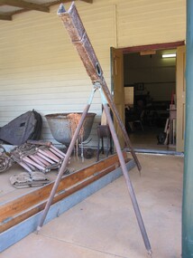 Parks Victoria - Port Campbell Rocket Shed
Rocket launcher
Rocket equipment which has been used in various lifeboat and rocket stations on the Victorian Coast. It is unclear if this is the original rocket equipment from Port Campbell. This equipment, if not original has been used in rescue operations and is identical to the equipment that has been in use at Port Campbell from C.1890 onwards.Metal, brass and timber tripod structure with a channel or trough to support the rocket. It has a pendulum and dial to measure the height trajectory. Very long wooden box with hinged lid painted a green-grey colour with four brass hinges and two rusted metal hooks. -
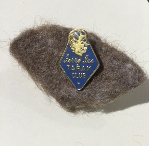 Mont De Lancey
Badge, GTV Channel 9, c1960's
The Tarax Show was an early Australian children’s TV program on GTV-9 in Melbourne running from 1957 to 1969. A favourite character of the show was the mischievous doll Gerry Gee and the Melbourne ventriloquist Ron Blaskett. Small blue and gold triangular enamel badge with the Gerry Gee ventriloquist doll face symbol in gold at the top. It is attached by a metal pin at the back onto a piece of brown felt. The Gerry Gee Tarax Club was formed 1960 - 1965 by GTV Channel 9.Gerry Gee TARAX CLUB with the doll face at the top. Small gold symbol at the bottom of the badge.television, children, gerry gee, club badges, membership badges, puppets -
Tatura Irrigation & Wartime Camps Museum
Carry Case, 1920
Used in conjunction with dumpy level, by Mr. Craven to survey agricultural land in the Goulburn Valley for the pruposes of setting out farm irrigation channels and check banksRectangular wooden box, divided into 5 sections with lid attached and closed with 2 metal fasteners on to 2 screws on the lid and key hole lock (no key). 2 leather straps with 2 buckles are attached by 2 metal bars, small screw driver and metal cap from telescope on dumpy level.carry case, dumpy level, craven b, tatura, surveying, irrigation, terrestrial -
Glenelg Shire Council Cultural Collection
Souvenir - Stubby Holder, n.d
Neoprene stubby holder, cylindrical, open top; yellow outside, black print, black depiction of Gordon Hotel.Front: 'GORDON HOTEL PUB TAB 63 BENTINCK STREET SKY CHANNEL PORTLAND, VIC KENO Ph: (03) 5523 1121 TATT'S Fax: (03) 5523 5958' MEALS 7 DAYS ACCOMMODATION