Showing 11201 items matching "circa"
-
 Ringwood and District Historical Society
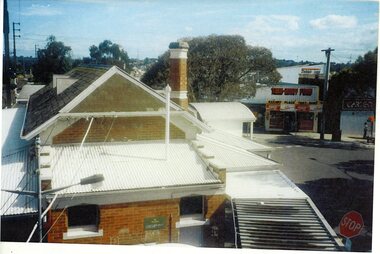
Photograph, Ringwood Railway Station before development- circa 2000
Coloured photograph"Written on back of photograph" Ringwood station before development. Roof view -
 Ringwood and District Historical Society
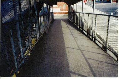
Photograph, Ringwood Railway Station before development- circa 2000
Coloured photograph"Written on back of photograph" Ringwood station before development. Ramp over track -
 Ringwood and District Historical Society
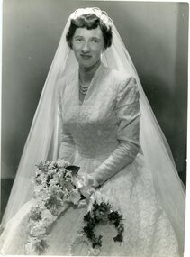
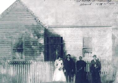
Photograph, The Ringwood Studio, Wedding of Miss P L Swifte of Boronia . circa 1960's
Black and white photograph"Written on back of photograph" 21st May Wedding of Miss P L Swifte of Olive Grove Boronia to Mr Lilley of Victoria Street East Ringwood. -
 Ringwood and District Historical Society
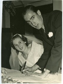
Photograph, Hall - Reid Weddiing -circa 1960's
Black and white photograph"Written on back of photograph" Hall - Reid Wedding -
 Ringwood and District Historical Society
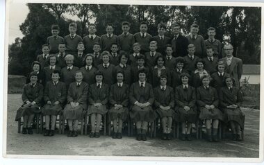
Photograph, Ringwood High School - Class photograph Circa 1960's
Black and white photograph"Written on back of photograph" List of student names -
 Ringwood and District Historical Society
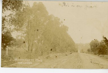
Photograph/Postcard, Warrandyte Road, Ringwood Circa 1900's
Sepia photograph/post card"Written on back of Post Card" Writings from a Cousin -
 Ringwood and District Historical Society
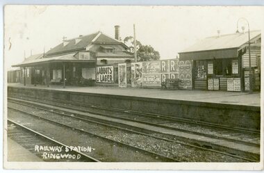
Photograph/Postcard, Ringwood Railway Station Circa 1940's
Black and white photograph/post card"Written on back of photograph" Writings between friends -
 Eltham District Historical Society Inc
Map, Geoff Braithwaite, Braithwaite ma0p of Eltham circa 1920
A3 photocopy of hand drawn map of Eltham created by Geoff Braithwaite (1914-2008) of his memory of the township about 1920. It includes names of streets and property owners. Folder of information on Geoff Braithwaite Includes A3 photocopy of hand drawn map of Eltham with coloured shading of Eltham in 1920s and 1930sharry gilham collection, eltham, 1920, geoff braithwaite, map, smart family cottage, eltham cemetery, flora caroline braithwaite (nee gamble), geoffrey braithwaite -
 Eltham District Historical Society Inc
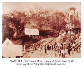
Work on paper (Sub-Item) - Photograph, The Union Mine, Diamond Creek circa 1900
The Union Mine operated until 1916.diamond creek, gold mine, miners, nillumbik historical society -
 Eltham District Historical Society Inc
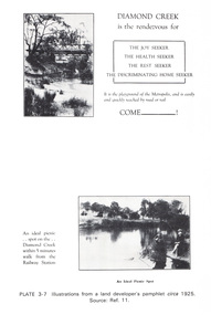
Work on paper (Sub-Item) - Photograph, Illustrations from a land developer's pamphlet promoting Diamond Creek, circa 1925
Photos illustrating the Diamond Creek with a bridge over it and two people sitting by the creek, one is fishing with text describing the kind of person who may like to come to the township. diamond creek, advertising, promotion, land development, real estate -
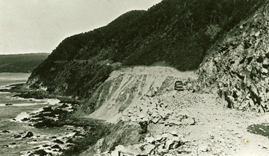
 Lorne Historical Society
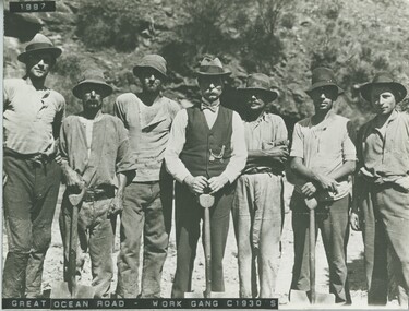
Photograph, Great Ocean Road Work gang. circa 1930's
Photograph showing 7 workmen with shovels.work-gang. 1930. shovels -
 Lorne Historical Society
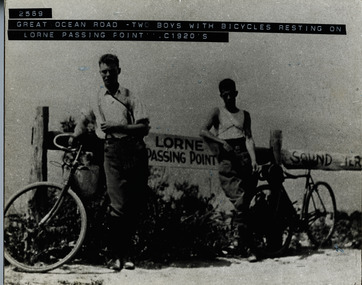
Photograph, Two boys with bicycles resting at Lorne Passing Point circa 1920
Photograph of two young men with bicycles leaning against post inscribed "Lorne Passing Point"g.o.r: circa-1920; bicycle-riders: lorne-passng-point -
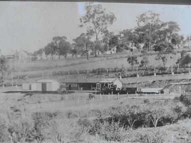
 Lorne Historical Society
Photograph, G.O.R Construction Cumberland circa 1920
Workmen with tractor, cement mixer G.O.R Cumberland Riverg.o.r.; cumberland, ; workmen-tractor-cement-mixer; -
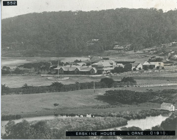 Lorne Historical Society
Photograph - Photograph Erskine House Lorne Circa 1910, Erskine House and Lorne circa 1910
View of Erskine House and Lorne Circ 1900lorne, erskine house -
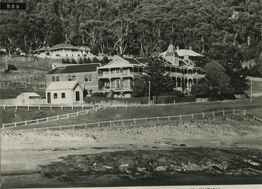 Lorne Historical Society
Photograph - Photograph of a Rose Series Picture Postcard, The Rose Series 2133, The Pacific Hotel Circa 1920
Grand Pacific Hotel depicted on The Rose Series 2133 Postcard C. 1920rose series 2133, grand pacific, circa 1920 -
 Greensborough Historical Society
Photograph - Digital Image, Greensborough Station, circa 1923, 1923c
View of Greensborough Station, c1923.. Digital copy of black and white photographgreensborough station -
 Greensborough Historical Society
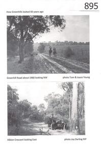
Photograph, Greenhills circa 1960, 1960c
The Greenhills area of Greensborough is now a suburban area. These photographs, taken in the 1960s, show it as open bush and farmland. Greenhills is designated a 'semi-bush precinct' by Banyule Council, due to its vegetation and large blocks of land.Copies of 4 black and white photographs.Captions identify each location and the photographer.greenhills, semi-bush precinct, tom young, joy darling, greenhill road, albion crescent -
 Greensborough Historical Society
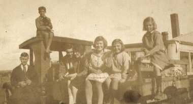
Photograph - Digital image, Barnett and Blackbourn circa 1922, 1922c
Members of the Barnett and Blackbourn families at rear of 122 Main Road Lower Plenty. On roof: Laurie Barnett. On ground left to right: Ferdinand Barnett, Ted and Jean Blackbourn, Myrtle, Marjory, Ivy Barnett. Photographs from the collection of Peter Blackbourn, a descendant of the Chapman Stock family. Annotations to photos by Peter Blackbourn.Digital copy of black and white photograph.peter blackbourn, barnett family, blackbourn family -
 Greensborough Historical Society
Photograph - Digital image, Lower Plenty Sunday School circa 1936-38, 1936-1938
Children at Lower Plenty Sunday School; the teacher came from Heidelberg. Photographs from the collection of Peter Blackbourn, a descendant of the Chapman Stock family. Annotations to photos by Peter Blackbourn.Digital copy of black and white photograph.peter blackbourn, lower plenty sunday school -
 Greensborough Historical Society
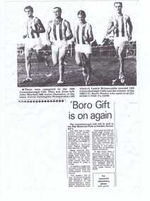
Newspaper Clipping, Greensborough Gift circa 1969, 1969c
News article about the Greensborough Gift of 1969.Digital copy of news clipping, black text and image.greensborough gift -
 Greensborough Historical Society
Photograph, Partington's Flat Greensborough Circa 1968, 1968_
Partington's Flat Greensborough was created in the 1950s when Heidelberg Council bought 12 acres from the Partington family to make the park. Fruit trees can be seen in this photograph. Gary Partington (on 2/2/2017) was hazy on the precise locale of the photo. It may have been a track from Willis Vale house going toward the Plenty River with maybe Marsh's Pine trees in the right background defining the border fence line of the Marsh Farm.Colour photographHandwritten on back "Partington's Flat Greensborough about 1968"alan partington, greensborough, partingtons flat, farms, landscapes, gardens -
 Greensborough Historical Society
Photograph - Digital image, Medhurst family at Booth Street Bendigo, circa 1899, 1899c
This photograph shows four people outside a house in Booth Street Bendigo.Digital copy of black and white photograph.medhurst -
 Greensborough Historical Society
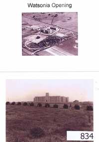
Photographs, Watsonia opening; Loyola seminary. Circa 1934, 01/08/1934
The Society of Jesus (Jesuits) opened the seminary in 1934. These photographs were part of the advertising for the opening ceremony. The Jesuit Order had a presence on the site from 1934 to 1974 where a house of formation and studies for the Society of Jesus was located (the current Old Loyola building purchased by the College in 2002). Loyola College Watsonia now occupies the site.1934 photographs showing the site before the residential development in the area.Four photographs and one photocopy. Aerial and ground views.loyola college, jesuits, loyola seminary -
 Greensborough Historical Society
Photograph - Digital image, John Gibson et al, Isabel Luxford circa 1940, 1940c
Isabel Luxford possibly early 1940s in Greensborough.Digital copy of black and white photograph. luxford family -
 Greensborough Historical Society
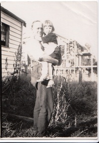
Photograph - Digital image, John Gibson et al, Jean Luxford in father Wallace's arms circa 1930, 1930c
Jean Luxford in father Wallace's arms with part built Poulter home behindDigital copy of black and white photograph. luxford family, poulter family -
 Greensborough Historical Society
Photograph - Digital image, John Gibson et al, Keith Luxford in backyard circa 1950, 1950_
Keith Luxford in backyard about 1950 with Cordner home right rear, Splatt home centre, Stopford home at left and Amiet property rear leftDigital copy of black and white photograph. luxford family, cordner family, splatt family, stopford family, amiet family -
 Greensborough Historical Society
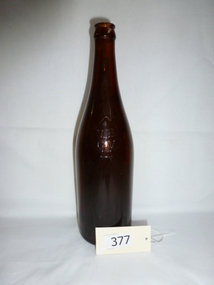
Bottle, MBCV brown beer bottle, circa 1930s, 1930s
Made as bitter ale container in the 1930s to 1940s, World War 11 era.Found near the former WW2 WAAAF base, north west of Greensborough.Brown glass bottle, 26 fluid ounce capacity. MBCV in small spade on shoulder, Carlton "C" on base.MBCV (Manufacturers Bottle Company of Victoria)beer bottle, mbcv, world war ii, glass, spade mark -
 Eltham District Historical Society Inc
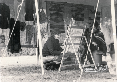
Photograph, Eltham Living and Learning Centre Open Day, tent in front of car park area, circa 1986, 1986c
Eltham Living and Learning Centre activities Black and white photographclasses, eltham living and learning centre -
 Warrnambool RSL Sub Branch
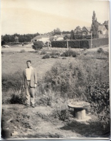
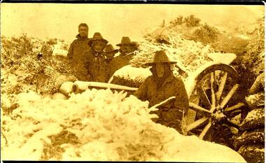
AWM collection, https://www.awm.gov.au/collection/P10427.022/, H visiting a gun crew on Gallipoli, circa 29 November 1915, following the snow-storm
snape collection -
 Ringwood and District Historical Society
Biography, Ringwood and District Historical Society, Interview notes - short biography on Miss Daisy Paddock, teacher at Ringwood State School, circa 1970s, c.1970s
Single page of notes/interview record of Miss Daisy Paddock, teacher at the Ringwood State School in Greenwood Avenue (now Federation Estate) - Interview write-up by Ringwood History Group.Transcript: "Miss Janet Daisy Paddock She was an extremely well-liked and well-regarded teacher at the old RW State School in Greenwood Ave (Now Federation Estate). She taught between the years of 1927 until 1941, then again after the war from 1951 until final retirement in 1961. In fact she was so liked that her former pupils formed "The 2997 Club" , which met in her honour every year for a meal (and, of course, their guest of honour). 2997 was the RW SS number. In some of her letters about early life in RW, she recalls the RW Mail being produced and printed in a small wooden building in Adelaide St. [Adelaide St is officially no longer on the RW map but it went from the highway nearly to Mullum Creek, between Melbourne St and Warrandyte Road.^ In fact there is an unmarked 100 metres of road that is on the west side of Officeworks that ends in a roundabout at the bottom of Eastland carpark. I don't believe it is exactly in the same position as the old Adelaide Street but it pretty close. That would put the old Mail office in the vicinity of the Maroondah Council service centre in Eastland.] She also recalls that there were nearly a dam on every corner. In fact, I recall in my 1950s/60s childhood that there were still many dams around. As I previously mentioned, with the RW-Mitcham claybelt, there wasn't much top soil and the orange clay is very fine, so when the banks of the dam get wet, it wass very slippery. I often remember playing around in those dams, as most boys did in those days. A friend and I spied an old bath used to water some horses so after some trial and errors we made it waterproof and fashioned a couple of paddles out of wooden fence pailings. The first launch in the local dam was fine and we managed to manouver through the bullrushes into the middle. The only thing that I forgot about was that I had a d<^ that went everywhere with me and, rather than bark from the bank, he swam over to us and tried to get aboard. Bath tubs are not known for their seaworthness and he tipped us all in the drink. Of course the bath sank like a rock. We scrambled on the bank and he added insult to injury when, as all dogs do, gave the usual shake and sprayed us with water. My mind often comes back to one dam right next to the Croydon pub - that provided water to the Magg's orchard - dug in the usual fashion on about 3 metres deep scraped in the local clay, it was at this dam in the early sixties that a young boy drowned. After that we were pretty careful around dams. Going back to Daisy's memories, she recalls that the kids often started late on Monday mornings as Monday was Market Day at RW. They used to watch the stock being herded into the yards and people getting off the steam trains. Her family home was at Gruyere and her father used to drive to RW market and stop midway at the Burnt Bridge hotel and rest the horses. [I suspect that he may have watered other things besides the horses.] They eventually moved to RW in Thanet St. Miss Paddock still remembers the old RW school at the corner of RW St and Whitehorse Road, it was very small so they built the new school in Greenwood Ave. RW had a population of around 2,(K)0 when Daisy became an Assistant Class Five. She used to walk through the open paddocks, surrounded by bush and orchards. She goes on to say that the bush was alive with wildlife and a natural playground for the children. Miss Paddock was a member of the Soroptomist Club in RW (equivalent to Rotary), active in the church and local community. At our archives, we have a plaque that grac^ the entrance to the school, naming it the Miss Daisy Paddock library, in honour of a great woman in our city."