Showing 19414 items
matching coast
-
 Lakes Entrance Historical Society
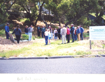
Photograph, John Street Rain Forest Revegetation Reserve, Lakes Entrance Victoria, 2000 c
Colour photograph of about 20 local residents listening to Bill Peel at the proposed John Street Rain Forest Revegetation Reserve John Street Lakes Entrance Victoriacoast, environment, people -
 Lakes Entrance Historical Society
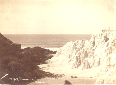
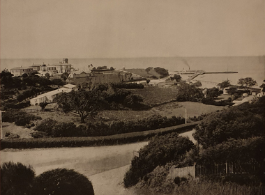
Photograph, A Davis Eden, Pinnacles Eden N.S.W, 1940 c
Sepia toned photograph showing a view of the ocean from the spectacular cliffs known as the Pinnacles Eden N.S.W.The Pinnacles Edencoast, ocean, topography -
 Flagstaff Hill Maritime Museum and Village
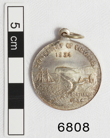
Medal - Commemorative, Centenary of Victoria, Melbourne and Portland, 1935
This commemorative medal celebrates a colonisation of two towns, now cities, in Victoria; Melbourne and Portland. The medal shows the significance placed on the colonisation of Victoria and the growth of the hundred year period. Medal, silver. with hole and ring at the top. Obverse: Sailing Ship, Coast, Boat on shore, 3 men. Reverse Colonial man on grass, river, city buildings on other river bank Medal commemorates the centenary of Victoria and Portland 1834 and Melbourne 1835. "CENTENARY OF VICTORIA 1934" & "PORTLAND 1834", "CENTENARY OF MELBOURNE 1935" & "1835" flagstaff hill, warrnambool, shipwrecked-coast, flagstaff-hill, flagstaff-hill-maritime-museum, maritime-museum, shipwreck-coast, flagstaff-hill-maritime-village, medal, centenary medal, centenary of victoria, centenary of melbourne, 1834-1934, 1835-1935, colonial, centenary of portland, colonisation of victoria -
 Glenelg Shire Council Cultural Collection
Booklet, Text Gilbert P. Whitley. Illustrated by Mary E. Soady, Solvol Fish Book, 1940-1950
Soft cover book, promotional item for Solvol soap. Describes life and habitats of 80 Australian fishes, includes colour illustrations. Covers, coloured depiction of typical fishing scene along N.S.W. coast. Front cover: young boy holding two fish. -
 Glenelg Shire Council Cultural Collection
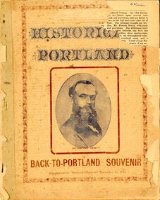
Booklet - Booklet - Historical Portland Souvenir, Victoria, Nov-22
Twenty-four page booklet 'HISTORICAL PORTLAND', a Back-to-Portland souvenir supplement to 'Portland Observer', November 16, 1922. Likeness of Edward Henty on front page, Portland Bay from Battery Point, and Portland coast view from Lighthouse Point, on back. -
 Lakes Entrance Historical Society
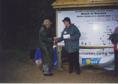
Photograph - Coastcare, Lakes Post Newspaper, 2000
Colour photograph Jack Whadcoat sign builder and Ann Guy Project Officer from the East Gippsland Arts and Recreation Access Group at the launch of signage and wheelchair access track at Lake Bunga Foreshore funded by Coast Action Coastcare. Lakes Entrance Victoria volunteering, clubs, recreation facilities -
 Orbost & District Historical Society
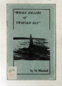
books, Whale Killers of Twofold Bay, circa 1960
Author, Mary Mitchell was the daughter of Charles Wellings early resident of Eden. Charles took many of the early photos of Eden while his brother, Henry, did the research on the Imlay Bros (very early settlers of Orbost) and early Twofold Bay settlers. Mary Wellings married Roy Mitchell of Lower Towamba. In Eden there are streets and a park named for both families.These books record the history of the whaling industry on the south coast of New South Wales.Two copies of a small thin ten page booklet with blue laminated covers. It has black print and a black photo of a whale tail on the front cover.It was written by Mary Mitchell. The book relates the history of whaling at Twofold Bay on the south coast of New South Wales.2116.1 - has a library sticker on the front cove - bottom left hand cornertwofold-bay whaling mitchell-mary welliings -
 Otway Districts Historical Society
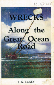
Book, Wrecks along the Great Ocean Road, 1974
Many fine ships were lost along Victoria's western coastline and evidence suggests a number of unidentified wrecks went down many years earlier.Wrecks along the Great Ocean Road. Shipwrecks of the west coast from Point Lonsdale to Portland. J.K. Loney. 4th ed. Dimboola (Vic); J.K. Loney; 1974. iii, 137 p.; illus, maps. Soft cover. ISBN 0 9599853 8 7shipwrecks; great ocean road; j.k. loney; west coast; strandings;portland; port fairy; warrnambool; point lonsdale; -
Port Melbourne Historical & Preservation Society
Document - Sinking of the hospital ship Centaur, 2010
16 loose pages (each individually numbered) regarding the sinking (by torpedo) of the "Centaur" hospital ship. The "Centaur " was sunk off the coast Cape Morton on 14 May 1943. 268 people died and 64 survived. The wreckage was found on 20 December 2009. World War IIreturned services league, rsl, war - world war ii, transport - shipping, martin pash, merchant navy -
 Ballarat Tramway Museum
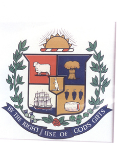
Photograph - Colour Photograph/s, 2007
Photographic reproduction of the original Coat of Arms of the City of Geelong and the city motto "By the right use of God's gifts", used from 1849 to 1981.On rear in ink "(7),", "WFS Collection", a "William Scott" address label. In writing "1849 to 1981" / The original coast of arms for Geelong. William F. Scott Collection / Geelong Historical Centre".trams, tramways, crests, coat of arms, city of ballaarat, city of ballarat -
 National Vietnam Veterans Museum (NVVM)
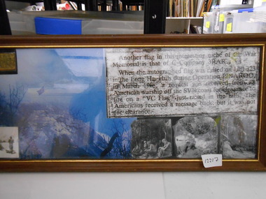
Photograph - Photograph, Collage, VC Flag
Framed Collage of C Company 3 RAR raised autographed Australian flag on Hill 323 in the Long Hai Hills during Operation Pinaroo in March 68. A request was received from an American Warship off the Coast to fire upon a newly raised "VC Flag". No clearance was givenc coy 3 rar, operation pinaroo, long hai hills, hill 323 -
 National Vietnam Veterans Museum (NVVM)
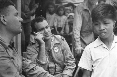
Photograph, Gibbons, Denis, Deformed Child
Denis Gibbons (1937 – 2011) Trained with the Australian Army, before travelling to Vietnam in January 1966, Denis stayed with the 1st Australian Task Force in Nui Dat working as a photographer. For almost five years Gibbons toured with nine Australian infantry battalions, posting compelling war images from within many combat zones before being flown out in late November 1970 after sustaining injuries. The images held within the National Vietnam Veterans Museum make up the Gibbons Collection. A black and white photograph of a RAAF Medical Officer assisted by an RAAF Medic assess a young Vietnamese boy born with his ears deformed, during a Medcap at Bong Son Island off the coast of Vung Tau. The boy was taken to Vung Tau where surgeons rectified his problemraaf medics, bong son, vung tau, gibbons collection catalogue, vietnamese children, raaf medical officer, medcap, wounded children, bong son island, denis gibbons -
 Queenscliffe Maritime Museum
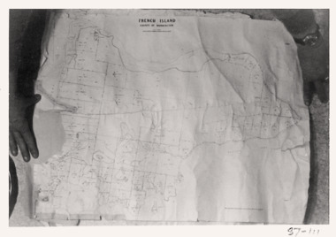
Map - French Island, County of Mornington, French Island map photographs x 2, c1987
Islands off Victorian coastFrench Island mapFrench Island map photographs x 2Reverse " Nil "french island -
 National Vietnam Veterans Museum (NVVM)
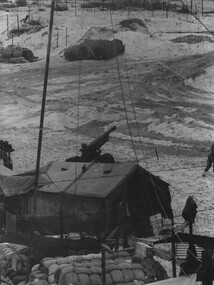
Photograph, Gibbons, Denis, Quiet Time
Denis Gibbons (1937 – 2011) Trained with the Australian Army, before travelling to Vietnam in January 1966, Denis stayed with the 1st Australian Task Force in Nui Dat working as a photographer. For almost five years Gibbons toured with nine Australian infantry battalions, posting compelling war images from within many combat zones before being flown out in late November 1970 after sustaining injuries. The images held within the National Vietnam Veterans Museum make up the Gibbons Collection. A black and white photograph of a quiet time, in a gun detachment area at an Australian Fire Support Base, in the sand dunes, on the coast, South East of the 1st Australian Task Force Base at Nui Dat, Phuoc Tuy Province, South Vietnam. The Battery was supporting Infantry in the area (circa June 1970).photograph, fire support base, 1st atf base, nui dat, phuoc tuy province, infantry, gibbons collection catalogue, photographer, vietnam war, denis gibbons, 105mm howitzer, nui thai vai mountains -
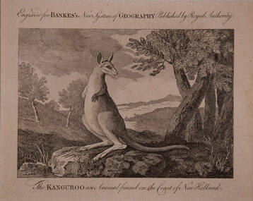 Bass Coast Shire Council - Robert Smith Collection
Artwork, other - The Kanguroo, Anonymous English
An animal found on the Coast of New Holland Engraving kangaroo -
Glenelg Shire Council Cultural Collection
Negative - Negative - Dutton's Lookout, Portland, c. 1934
Negative for black and white photograph. View from Dutton's Lookout, Portland, looking east. Ocean Pier, Railway Pier, Fishermen's Breakwater, Battery Point, Lawrence Rocks.duttons lookout, negative, portland, coast -
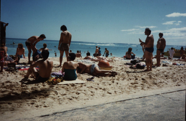 Federation University Historical Collection
Photograph - Photograph - Colour, Beach Scene, c1980, c1980s
Colour photograph of bathers on a beach, possibly in America. beach, bathers, holiday, coast -
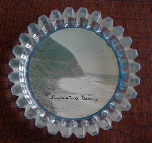 Victorian Interpretive Projects Inc.
Image of souvenir ware, Apollo Bay
Apollo Bay is located between Wye River and Cape Otway on Victoria's scenic coastal route, the Great Ocean Road. In the 1840s the Henty brothers established a whaling station at Point Bunbury on the western end of the bay. The bay was named by Captain Loutit in 1845 when he sheltered his vessel, the Apollo during a storm. (http://en.wikipedia.org/wiki/Apollo_Bay)A coloured picture of a coastline attached to a glass butter plate. The coastline is Cape Patton, Apollo Bay, Victoria"Apollo Bay"apollo bay, beach, coast, souvenir -
 Ballarat Heritage Services
Photograph - Colour, Clare Gervasoni, Looking Towards Port Fairy from Killarney Beach, Victoria, 2018, 26/12/2019
Colour photograph fron Killarney Beach, Victoria.killarney beach, coast, beach, port fairy -
 Ballarat Heritage Services
Image, Sorrento, on Port Phillip, c1918, c1918
Image of Sorento, Port Phillip.sorrento, port phillip, beach, coast -
 Lakes Entrance Historical Society
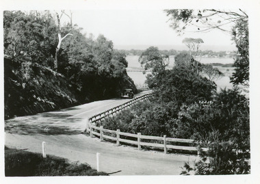
Postcard - Princes Highway Kalimna, 1940c
Plus 3 identical black and white|Plus 2 tinted, (one tinted copy has inscription, 'Jemmy's Point')Black and white small format postcard of the road as it winds around Jemmys Point. It shows a motor car travelling up the hill between the steep cliff of the road cutting and the post and rail guard fence. Glimpse of Bullock Island, lake and hummocks in distance. Lakes Entrance Victoriafences, roads and streets, transport, coast -
Lakes Entrance Historical Society
Book, Gippsland Heritage Journal, 1996
No 20 of a series contains articles on Boole Poole, Snake Island, Mental illness, Skyline Tours, Rev. Daniel Gunson, Trida School, Horse troughs all in Gippsland Victoria. Many photographs, copy of Lithograph of Hop pickers.agriculture, schools, tourism, coast -
 Lakes Entrance Historical Society
Photograph - Buaga, 2011
Colour photograph of scallop boat Buaja at sea, showing three men on deck working the dredge, at Lakes Entrance, Victoria.ships and shipping, fishing industry, coast, dredging -
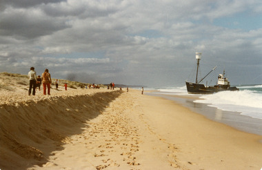
 Lakes Entrance Historical Society
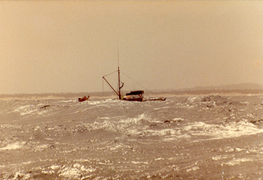
Photograph - Dageraad, 1981
Vessel stranded 26 April 1981Colour photograph of the fishing vessel Dagaraad aground on the ninety mile beach beside the entrance barships and shipping, fishing industry, coast, shipwrecks -
 Lakes Entrance Historical Society
Photograph - Dageraad, 1981
Vessel stranded 26 April 1981Colour photograph of the fishing vessel Dagaraad aground on the ninety mile beach beside the entrance barships and shipping, fishing industry, coast, shipwrecks -
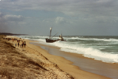 Lakes Entrance Historical Society
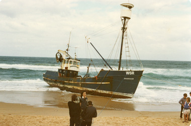
Photograph - Dageraad, 1981
Vessel stranded 26 April 1981Colour photograph of the fishing vessel Dagaraad aground on the ninety mile beach beside the entrance bar. Camera crew interviewing a lady on beach with vessel in background, two children also in photo. Lakes Entrance Victoriaships and shipping, fishing industry, coast, shipwrecks -
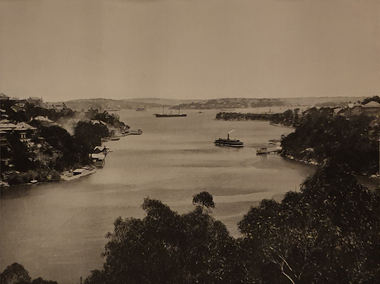 Ballarat Heritage Services
Photograph, Mosman Bay, New South Wales
Coastal scene at Mosmanmosman, sea, coast, ferry -
Lakes Entrance Historical Society
Book, Bird, Eric and Lennon, Jane, Making an Entrance- The Story of the artificial entrance to the Gippsland Lakes, 1989
Revised edition of an earlier publication 'The Entrance to the Gippsland Lakes'. Contains illustrations, Maps, Diagrams timed for the centenary of the opening of the artificial entrance at Lakes Entrance VictoriaRevised edition of an earlier publication 'The Entrance to the Gippsland Lakes'. Contains illustrations, Maps, Diagrams timed for the centenary of the opening of the artificial entrance at Lakes Entrance Victoriaexploration, coast, transport, civil engineering -
 Lakes Entrance Historical Society
Postcard - North Arm bridge Lakes Entrance Victoria c1930, 1930c
Black and white small format postcard showing the town, North Arm bridge, Cunninghame Arm, sand hummocks, taken from Mt Barkly / Jemmys Point. Lakes Entrance Victoriabridges, township, coast, waterways -
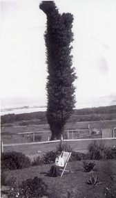 Lakes Entrance Historical Society
Photograph - The tree on Merrangbaur Hill, 1920c
Black and white photograph of The Tree on Merrangbaur Hill. This dead iron bark tree covered with vine, was for many years a landmark for vessels at sea. View of sand hummocks and Cunninghame Arm in background. Lady seated on deckchair in Merrangbaur House garden, Lakes Entrance Victoria.guesthouses, topography, coast, local history