Showing 3431 items
matching distance
-
 Wangaratta Historical Society
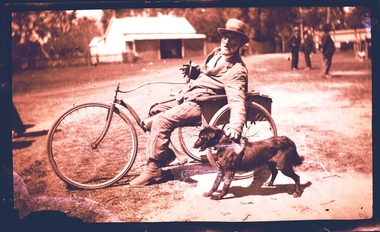
Three Wheeled Dog Cart, Three Wheeled Cart Pulled by Dog, Unknown
Mr Ernie Fitzgerald of Tarrawingee, traveled to Wangaratta, a distance of 14 Kilometres on Market days for his provisions. He was pulled along by his one of two dogs attached to a hand held leather strap (recounted by a witness who remembers Mr Fitzgerald's weekly visit to Wangaratta for supplies at The CoStore). This vehicle remains in possession of his family. This was an unique mode of transport in the 1930's, the witness was a child at the time and remembers Mr Fitzgerald and his dogs and the cart quite clearly. This is a unique mode of transport for the area, is documented and still in existence. WHS Inc were presented with 10,000 glass plate negative from Thelma & Vine Photographic Studios Murphy Street Wangaratta from the 1860's - 1950's. An example of a glass plate negative is featured above of Mr Ernie Fitzgerald of Tarrawingee who traveled to Wangaratta, a distance of 14 Kilometres on Market days for his provisions. He was pulled along by his one of two dogs attached to a hand held leather strap. (Recounted by a witness who remembers Mr Fitzgerald's weekly visit to Wangaratta for supplies). This vehicle remains in possession of his family. Unknownthree wheel steerable chair -
 Eltham District Historical Society Inc
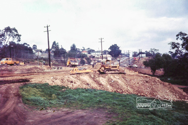
Photograph, Russell Yeoman, Main Road duplication roadworks between Bridge Street and Shire of Eltham offices, 1968, 1968
Viewed from the southern end of the Eltham Shire Office, Panther Place in centre distance and Bridge Street in distance running down from Main RoadDigital file only; created from original colour positive slide transparencystreets, main road, eltham shire office, bridge street, duplication, panther place, road construction, road widening, russell yeoman collection -
 Phillip Island and District Historical Society Inc.
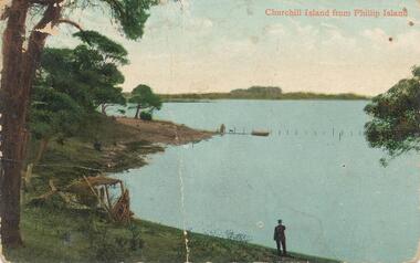
Photograph - Post Card, 1910's
One of 17 photographs donated by Olive BlameyColour postcard. Churchill Island in the distance taken from Phillip Island. Figure at water's edge. Figures, dog and boat in the centre. "Churchill Island from Phillip Island" Letter written by Marie of Everton Cowes to Millie addressed to Mrs H. Blamey, "Roslyn" The Parade Ascot Vale.churchill island, phillip island -
 Halls Gap & Grampians Historical Society
Photograph - B/W, C 1940s (?)
Photo shows an unsealed section of Grampians Rd. near Jimmy's Creek. The sharp profile of Mt Frederick can be seen in the distance.access routes, roads -
 Halls Gap & Grampians Historical Society
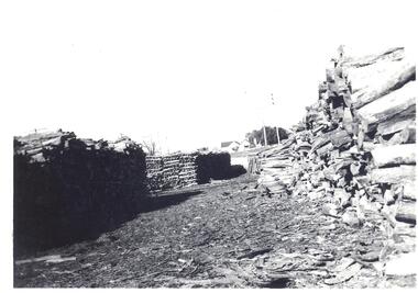
Photograph - B/W
Reverse----- Stacks of wattle bark bundlesBlack and White photo showing stacks of bundled wattle bark ready for transporting to mill. Weather board house in far distance.Reverse----- Stacks of wattle bark bundlestimber industries, wattlebark stripping -
 Ringwood and District Historical Society
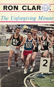
Book, The Unforgiving Minute (Ron Clarke) - Alan Trengove
Ron Clarke, among the greatest distance runners the world has seen, reveals the secrets behind his achievements to Alan Trengove -
 Benalla Art Gallery
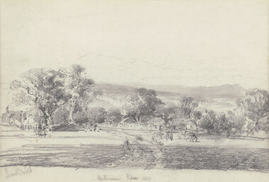
Drawing, Louis BUVELOT, Melbourne Kew (Yarra Glen), 1869
Born: Morges, Vaud, Switzerland 1814; Lived and worked: Brazil 1835-1852; Arrived: Melbourne, Victoria, Australia 1865; Died: Melbourne, Victoria, Australia, 1888ColonialLedger Gift, 1987Rural landscape with two animals beside a track leading towards buildings and outbuildings surrounded by trees with hills in distance. Timber frame.Recto: Signed "Louis Buvelot" in grey pencil in l.l.c of composition; Titled and dated 'Melbourne Kew 1869' in grey pencil in lower centre of compositiondrawing, landscape, figures, trees, colonial, road, animals -
 Tatura Irrigation & Wartime Camps Museum
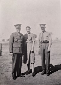
Photograph, Melrose, Tackeberry and Blight, Original 1942, copy 1989
WW2 Internment Camp 1 Tatura. Army staff and Nursing staff. Major Blight, Officer in Command of all the Tatura Camps (r), A.A.N.S. Sister Melrose; Colonel Tackeberry, Officer in Charge Camp 1 Tatura. 1942.Black and white photograph of two men and a lady, all in Army uniform. Post to the left side and trees in far distance behind. a.a.n.s., sister melrose, major blight, colonel tackeberry, internment camps -
 Tatura Irrigation & Wartime Camps Museum
Photograph, New Fence Styles - Irrigation Channels, 1957
Taken by the photographer for Victoria State Rivers and Water Supply Commission.Large black and white photograph Concrete "fence" styles - One male worker handling sample in mid-distance, right of centre.Below photo: "New Fence Styles to enable easy access onto Commission Channel Reserves."irrigation, victoria state rivers and water supply commission, channel maintenance -
 Robin Boyd Foundation
Slide, Robin Boyd, 1970
Robin Boyd was appointed Exhibits Architect for the Australian Pavilion at Expo ‘70 in Osaka and travelled to Osaka several times in 1969-1970. Boyd designed the innovative Space Tube, which had over 25 exhibition boxes, projecting from it. Amongst the topics covered were Australian scientific innovation (including brain research, immunology, Antarctic research, Snowy Mountains Hydro-Electric Power Scheme, rainmaking, and the night sky), Australian sport, house interiors, car manufacturing, Australian music and art, and Japanese-Australian relations.Colour slide in a mount. Festival Plaza and the Tower of the Sun (in middle distance), Expo '70, Osaka, Japan. (Architect: Taro Okamoto.)Made in Australia / 1 / MAY 70M3expo 70, osaka, robin boyd, slide -
 Hume City Civic Collection
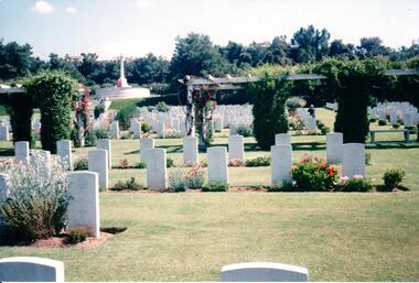
Photograph
Further information needed about this photograph.A coloured photograph of a war cemetery with garden beds around the headstones and an arbor in the middle distance. A raised cross is overlooking the cemetery area.KALOMBABE COM. WAR CEMETERY/ BEAUTIFULLY KEPTwar graves, war cemeteries, kalombabe commonwealth war cemetery, george evans collection -
 Hume City Civic Collection
Photograph, c 1978
On 4th August 1978 the construction of the Goonawarra Estate commenced. The estate was formerly known as the Goonawarra Farm and overlooked the Sunbury Township and the Jacksons Creek Valley. Plans for the development included a golf course, houses and community and recreational facilities. The golf course opened in 1980 and the housing construction continued throughout the last two decades of the twentieth century and into the twenty first century.A coloured photograph of the reflecting pool at the entrance of the Goonawarra Golf Club. The surrounding area has been landscaped and a display home is in the distance.goonawarra golf club, goonawarra farm, goonawarra housing estate, housing developments, sharkey, robert b., kilkenny homes, australian ideas homes pty.ltd., glamor homes, craftsmen homes., villa bella homes, george evans collection -
 Stawell Historical Society Inc
Slide, Ian McCann, Lake Bellfield base, 1960's
Colour Slide, showing the Base of Lake Bellfield, with two people in the mid distance, and more on the far wall. Also with three vechiles.grampians -
 Mt Dandenong & District Historical Society Inc.
Photograph
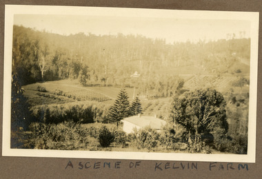
Most likely a scene of 'Mt Calvin', the homestead built by John William (Willie) Richardson for his wife Jeanie Green of Wandin. The house was built c1898 The Rowse family purchased the house and 60 acres when Willie and Jeanie Richardson with their 3 children moved to Brisbane. The Rowse family farmed the 60 acres for 35 years and the house was demolished in 1938. The photograph is from the album of Ivy May Child. Ivy May Child (1910 – 1989) was the daughter of Arthur Edward (Ted) Child (1878 – 1964) and Ethel May Madden (1888 – 1970). Ted Child was the son of Matthew Francis Child (1839 – 1933) and Martha Jeeves (1857 – 1926). He was the grandson of one of the early pioneers Francis Child. Ivy grew up on the family property on Childs Road and took many photographs. Most of these are glued into her photo album. The album covered the years from c1927 – 1932. Ivy married Henry William Burgess (1906 – 1968) in 1944. The photographs remain in their original state in the album with individual copies made. Black and white photograph with a house in the foreground looking over cultivated fields with treed hills in the background. A building is visible in the centre in the distance.Written below the photograph in the album" A SCENE OF KELVIN FARMmt calvin, kelvin farm, calvin farm, richardson, rowse, jeanie richardson, john william richardson, willie richardson -
 Mt Dandenong & District Historical Society Inc.
Photograph
The photograph is from the album of Ivy Child and shows a view across the Kalorama Valley. Ivy May Child (1910 – 1989) was the daughter of Arthur Edward (Ted) Child (1878 – 1964) and Ethel May Madden (1888 – 1970). Ted Child was the son of Matthew Francis Child (1839 – 1933) and Martha Jeeves (1857 – 1926). He was the grandson of one of the early pioneers Francis Child. Ivy grew up on the family property on Childs Road and took many photographs. Most of these are glued into her photo album. The album covered the years from c1927 – 1932. Ivy married Henry William Burgess (1906 – 1968) in 1944. The photographs remain in their original state in the album with individual copies made. Black and white photograph with bare trees in the foreground and a cleared area beyond with several homes visible. Bush in the distance runs into the hills.kalorama valley, kalorama, valley -
 South Gippsland Shire Council
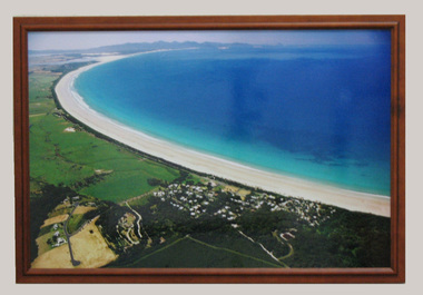
Photograph, Framed, 2003
Framed colour photograph featuring an aerial view of Waratah Bay, the beach and Sandy Point . Wilsons Promontory can be seen in the distance. -
 Kew Historical Society Inc
Photograph - Mother and child at the Yarra River, Kew, 1950s
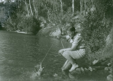
Canoeing on the River Yarra was a recreational traditional pastime for the people of Kew and Melbourne since settlement in the 1830s. Later in the century, canoes were frequently hired from boathouses.Print enlargement. Woman beside river holding a piece of string. Child swimming in Yarra. Canoe in distance beside bank with passengers.Reverse: "M Holmes"recreation -- canoeing, yarra river -- kew -
 Whitehorse Historical Society Inc.
Domestic object - Serviette Ring
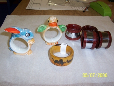
Part of|Mrs J. Lattins collection.Wooden serviette/napkin ring from Jerusalem featuring a camel and a man carrying something on his head with sand dunes in the distance.Jerusalemdomestic items, table setting -
 Lakes Entrance Historical Society
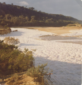
Photograph - Lake Bunga, Marie Fish, 1987c
Also three other colour phoptographs of foam at entrance and on lake after severe storm in June July 1978 numbers 03847.1, 03847.2, 03847.3 size 9 x 8.5 cmColour photograph showing foam across the open entrance after a severe storm, timbered hill in distance, Lake Bunga Victoriatopography, waterways -
 Lakes Entrance Historical Society
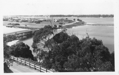
Postcard - North Arm bridge Lakes Entrance Victoria, 1950c
North Arm Bridge Lakes Entrance. (on back holidays 1951)Also 1x tinted photographic postcard identical scene 01162-2 good conditionBlack and white postcard of the North Arm bridge, lakes and western section of township, sand hummocks in distance. Lakes Entrance Victoriabridges, township -
 Lakes Entrance Historical Society
Photograph - Lake Bunga, 1920 c
Black and white photograph of Lake Bunga looking upstream from entrance with remains of old tramline in distance Lake Bunga Victoria waterways, topography -
 Falls Creek Historical Society
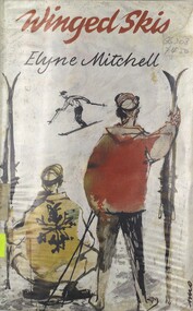
Book - Winged Skis, Elyne Mitchell, 1964
A novel written by Elyne Mitchell, a prodigious Australian author who wrote more than 30 books based around life in the High Country of Victoria. Her most widely know were the Silver Brumby series of 13 books published in more than 40 countries. In 1988 she received the Medal of the Order of Australia for services to literature. She write 26 novels as well as 10 non-fiction publications. Elyne Mitchell passed away on 4th March 2002 in Corryong, Victoria "Winged Skis" was her sixth novel. When Barry Mitchell discovers the track of a lone skier he is tempted to follow the tracks, but there are plenty of other things to do, like work hard for his exams, and learn to ski with his new friend Michael Hastings. Barry means to learn to be the perfect skier and spend his future life with the beauty of the mountains.This book of 247 pages includes illustrations and maps. The front cover features an illustration of two skiers looking at another skier in the distance.fictionA novel written by Elyne Mitchell, a prodigious Australian author who wrote more than 30 books based around life in the High Country of Victoria. Her most widely know were the Silver Brumby series of 13 books published in more than 40 countries. In 1988 she received the Medal of the Order of Australia for services to literature. She write 26 novels as well as 10 non-fiction publications. Elyne Mitchell passed away on 4th March 2002 in Corryong, Victoria "Winged Skis" was her sixth novel. When Barry Mitchell discovers the track of a lone skier he is tempted to follow the tracks, but there are plenty of other things to do, like work hard for his exams, and learn to ski with his new friend Michael Hastings. Barry means to learn to be the perfect skier and spend his future life with the beauty of the mountains.elyne mitchell, snowy mountains, juvenile literature australia -
 Lakes Entrance Historical Society
Postcard - Snowy River, Marlo Victoria, 1905 c
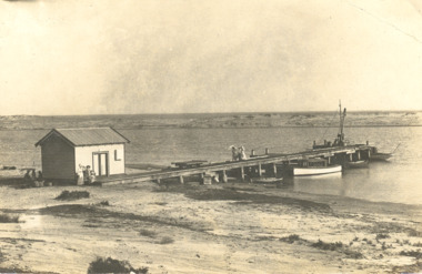
Black and white postcard of the wharf and goods shed, boats moored at jetty, sand dunes in distance at Marlo on the Snowy River Victoriawaterways, boats and boating, rivers -
 Clunes Museum
Photograph
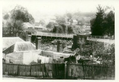
PHOTOGRAPH TAKEN LOOKING DOWNSTREAM TULLAROOP CREEK, ABOUT 1900. GOVERNMENT BRIDGE IN FOREGROUND, JULILEE BRIDGE IN MIDDLE DISTANCE, PORT PHILLIP MINE POPPET HED IN DISTANCE..1 ORIGINAL PHOTOGRAPH OF GOVERNMENT BRIDGE AND JUBILEE BRIDGE. TAKEN FROM CREEK PARADE. THE GOVERNMENT BRIDGE WAS BUILT CIRCA 1900. .2 ENLARGED PHOTOCOPY IN HANDWRITING : LOOKING DOWN-STREAM TULLAROOP CREEKABOUT 1900 GOVERMENT BRIDGE IN FOREGROUND JUBILEE BRIDGE IN THE MIDDLEbridges, jubilee bridge, goverment bridge -
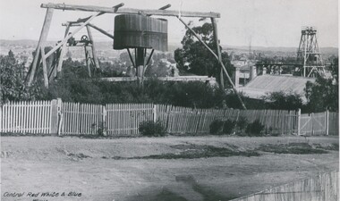 Bendigo Historical Society Inc.
Photograph - CENTRAL RED, WHITE AND BLUE BLUE MINE
black and white photo: whim , wooden wheel and frame; poppet legs at right, poppet legs at left centre distance. And at right of whim centre distance. Picket fence across front. 'Central Red White and Blue Whim' printed on bottom left corner. Written on back Eadies Whim & Central Blue - poppet legsorganization, business, central red, white and blue mine -
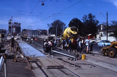 Melbourne Tram Museum
Slide, Keith Kings, 10/10/1968 12:00:00 AM
35mm Kodak white cardboard colour slide by Keith Kings of 10/10/1968 of the concreting of the track to connect St Kilda Road into the junction further to the south and Wellington St replacement - Queensway. Note the temporary tram stop. Note the overhead trucks in the distance. The Junction Hotel in the far distance. See Keith's slide notes.Keith Kings stamp and number "41-30" and exposure details. In ink "St Kilda Jtn Bypass works - temporary junction in St Kilda Rd, south of new junction, replaced by new track, 1050am Sunday.trams, tramways, st kilda junction, fitzroy st, st kilda rd, trackwork, high st, tram stops -
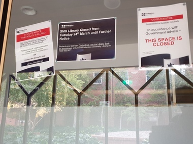 Federation University Historical Collection
Photograph - Colour, Federation University SMB Campus library Covid 19 Lockdown Notices, 2020, 23/04/2020
On 12 January, the World Health Organization (WHO) confirmed that a novel coronavirus was the cause of a respiratory illness in a cluster of people in Wuhan City, Hubei Province, China, who had initially come to the attention of the WHO on 31 December 2019. On 3 March, the Reserve Bank of Australia became the first central bank to cut interest rates in response to the outbreak. Official interest rates were cut by 0.25% (25 base points) to a record low of 0.5%. On 12 March, the Federal Government announced a A$17.6 billion stimulus package, the first since the 2008 GFC. he package consists of multiple parts, a one-off A$750 payment to around 6.5 million welfare recipients as early as 31 March 2020, small business assistance with 700,000 grants up to $25,000 and a 50% wage subsidy for 120,000 apprenticies or trainees for up to 9 months, 1 billion to support economically impacted sectors, regions and communities, and $700 million to increase tax write off and $3.2 billion to support short-term small and medium-sized business investment. On 16 March, Premier Dan Andrews and Minister for Health Jenny Mikakos declared a state of emergency for Victoria for at least four weeks. On 19 March, the Reserve Bank again cut interest rates by a further 0.25% to 0.25%, the lowest in Australian history. On 22 March, the government announced a second stimulus package of A$66bn, increasing the amount of total financial package offered to A$89bn. This included several new measures like doubling income support for individuals on Jobseeker's allowance, granting A$100,000 to small and medium-sized businesses and A$715 million to Australian airports and airlines. It also allowed individuals affected by the outbreak to access up to A$10,000 of their superannuation during 2019–2020 and also being able to take an additional same amount for the next year. on the same day Victorian Premier Daniel Andrews announced on 22 March that the state will bring the school holiday forwards to 24 March from 27 March. On 30 March, the Australian Federal Government announced a $130 billion "JobKeeper" wage subsidy program offering to pay employers up to $1500 a fortnight per full-time, part-time or casual employee that has worked for that business for over a year. For a business to be eligible, they must have lost 30% of turnover after 1 March of annual revenue up to and including $1 billion. For businesses with a revenue of over $1 billion, turnover must have decreased by 50%. Businesses are then required by law to pay the subsidy to their staff, in lieu of their usual wages. This response came after the enormous job losses seen just a week prior when an estimated 1 million Australians lost their jobs. This massive loss in jobs caused the myGov website to crash and lines out of Centrelink offices to run hundreds of metres long.The program was backdated to 1 March, to aim at reemploying the many people who had just lost their jobs in the weeks before. Businesses would receive the JobKeeper subsidy for six months. On 2 April, the number of cases in Victoria exceeded 1,000, including over 100 healthcare workers. On 5 April, New South Wales Police launched a criminal investigation into whether the operator of Ruby Princess, Carnival Australia, broke the Biosecurity Act 2015 (Cwth) and New South Wales state laws, by deliberately concealing COVID-19 cases. On 6 April, the Department of Health revealed that 2,432 people recovered from the infection as the federal government started reporting recovery statistics. This is more than a third from the official number reported so far, Deputy Chief Medical Officer Professor Paul Kelly stating, "I think it is important. Firstly it really reinforces that message, which is a true one, that most people who get this disease do recover”. The day before, at 3pm, it was announced that 2,315 of the 5,687 confirmed coronavirus cases had recovered. May 2020 - An outbreak in Victoria at a meatworks that was later revealed to be Cedar Meats was announced on 02 May with eight cases. By 8 May, the cluster of cases linked to Cedar Meats in Victoria was 71, consisting of at least 57 workers and 13 close contacts, including a nurse, aged care worker and high school student. The number had increased to 75 by 9 May, 88 by 13 May, and 90 by 14 May. On 9 May, two Victorian cases were announced to be related to McDonald's Fawkner. By 18 May, this had increased to 12 cases, and on that day it was revealed that a delivery driver had tested positive, prompting the closing for cleaning of 12 more McDonald's locations: Melton East, Laverton North, Yallambie, Taylors Lakes, Campbellfield, Sunbury, Hoppers Crossing, Riverdale Village, Sandown, Calder Highway Northbound/Outbound, Calder Highway Southbound/Inbound, and BP Rockbank Service Centre Outbound. On 15 May, South Australia became the second jurisdiction, after the ACT, to be free of any active cases, however on 26 May, a woman returning from overseas who was granted exemption into South Australia from her hotel quarantine in Victoria tested positive for COVID-19. This was the first new case in 19 days for the state.[101] On 4 June, it was announced that the woman had recovered and the state was free of any active cases once again.[102] On 17 May, Victoria announced two further business sites had been shut down due to a suspected case at each. Domino's Pizza in Fairfield has been shut for two weeks, and mattress manufacturer The Comfort Group in Deer Park was closed from Friday 15 May to at least Wednesday 20 May. On 6 June, both New South Wales and Victoria reported no new cases for the previous 24 hours, with only Queensland and Western Australia reporting one new case each, the lowest national total since February. Western Australia also announced two old cases. However, the new case in Queensland was linked to the Rydges on Swanston cluster in Melbourne when a man who travelled from Melbourne to Brisbane on Virgin flight VA313 on 1 June tested positive.Colour photographs of closure signs on the E.J Tippett Library due to the Covid-19 Pandemic and associated lock down and social distancing requirements.covid-19, corona virus, pandemic, social distancing, ballarat school of mines, e.j. tippett library, lock down -
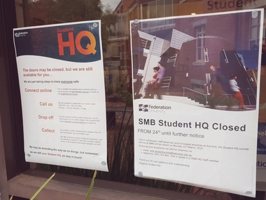 Federation University Historical Collection
Photograph - Colour, Federation University SMB Campus Student HQ Covid 19 Closure Notices, 2020, 23/04/2020
On 12 January, the World Health Organization (WHO) confirmed that a novel coronavirus was the cause of a respiratory illness in a cluster of people in Wuhan City, Hubei Province, China, who had initially come to the attention of the WHO on 31 December 2019. On 3 March, the Reserve Bank of Australia became the first central bank to cut interest rates in response to the outbreak. Official interest rates were cut by 0.25% (25 base points) to a record low of 0.5%. On 12 March, the Federal Government announced a A$17.6 billion stimulus package, the first since the 2008 GFC. he package consists of multiple parts, a one-off A$750 payment to around 6.5 million welfare recipients as early as 31 March 2020, small business assistance with 700,000 grants up to $25,000 and a 50% wage subsidy for 120,000 apprenticies or trainees for up to 9 months, 1 billion to support economically impacted sectors, regions and communities, and $700 million to increase tax write off and $3.2 billion to support short-term small and medium-sized business investment. On 16 March, Premier Dan Andrews and Minister for Health Jenny Mikakos declared a state of emergency for Victoria for at least four weeks. On 19 March, the Reserve Bank again cut interest rates by a further 0.25% to 0.25%, the lowest in Australian history. On 22 March, the government announced a second stimulus package of A$66bn, increasing the amount of total financial package offered to A$89bn. This included several new measures like doubling income support for individuals on Jobseeker's allowance, granting A$100,000 to small and medium-sized businesses and A$715 million to Australian airports and airlines. It also allowed individuals affected by the outbreak to access up to A$10,000 of their superannuation during 2019–2020 and also being able to take an additional same amount for the next year. on the same day Victorian Premier Daniel Andrews announced on 22 March that the state will bring the school holiday forwards to 24 March from 27 March. On 30 March, the Australian Federal Government announced a $130 billion "JobKeeper" wage subsidy program offering to pay employers up to $1500 a fortnight per full-time, part-time or casual employee that has worked for that business for over a year. For a business to be eligible, they must have lost 30% of turnover after 1 March of annual revenue up to and including $1 billion. For businesses with a revenue of over $1 billion, turnover must have decreased by 50%. Businesses are then required by law to pay the subsidy to their staff, in lieu of their usual wages. This response came after the enormous job losses seen just a week prior when an estimated 1 million Australians lost their jobs. This massive loss in jobs caused the myGov website to crash and lines out of Centrelink offices to run hundreds of metres long.The program was backdated to 1 March, to aim at reemploying the many people who had just lost their jobs in the weeks before. Businesses would receive the JobKeeper subsidy for six months. On 2 April, the number of cases in Victoria exceeded 1,000, including over 100 healthcare workers. On 5 April, New South Wales Police launched a criminal investigation into whether the operator of Ruby Princess, Carnival Australia, broke the Biosecurity Act 2015 (Cwth) and New South Wales state laws, by deliberately concealing COVID-19 cases. On 6 April, the Department of Health revealed that 2,432 people recovered from the infection as the federal government started reporting recovery statistics. This is more than a third from the official number reported so far, Deputy Chief Medical Officer Professor Paul Kelly stating, "I think it is important. Firstly it really reinforces that message, which is a true one, that most people who get this disease do recover”. The day before, at 3pm, it was announced that 2,315 of the 5,687 confirmed coronavirus cases had recovered. May 2020 - An outbreak in Victoria at a meatworks that was later revealed to be Cedar Meats was announced on 02 May with eight cases. By 8 May, the cluster of cases linked to Cedar Meats in Victoria was 71, consisting of at least 57 workers and 13 close contacts, including a nurse, aged care worker and high school student. The number had increased to 75 by 9 May, 88 by 13 May, and 90 by 14 May. On 9 May, two Victorian cases were announced to be related to McDonald's Fawkner. By 18 May, this had increased to 12 cases, and on that day it was revealed that a delivery driver had tested positive, prompting the closing for cleaning of 12 more McDonald's locations: Melton East, Laverton North, Yallambie, Taylors Lakes, Campbellfield, Sunbury, Hoppers Crossing, Riverdale Village, Sandown, Calder Highway Northbound/Outbound, Calder Highway Southbound/Inbound, and BP Rockbank Service Centre Outbound. On 15 May, South Australia became the second jurisdiction, after the ACT, to be free of any active cases, however on 26 May, a woman returning from overseas who was granted exemption into South Australia from her hotel quarantine in Victoria tested positive for COVID-19. This was the first new case in 19 days for the state.[101] On 4 June, it was announced that the woman had recovered and the state was free of any active cases once again.[102] On 17 May, Victoria announced two further business sites had been shut down due to a suspected case at each. Domino's Pizza in Fairfield has been shut for two weeks, and mattress manufacturer The Comfort Group in Deer Park was closed from Friday 15 May to at least Wednesday 20 May. On 6 June, both New South Wales and Victoria reported no new cases for the previous 24 hours, with only Queensland and Western Australia reporting one new case each, the lowest national total since February. Western Australia also announced two old cases. However, the new case in Queensland was linked to the Rydges on Swanston cluster in Melbourne when a man who travelled from Melbourne to Brisbane on Virgin flight VA313 on 1 June tested positive.Colour photographs of closure signs on the E.J Tippett Library due to the Covid-19 Pandemic and associated lock down and social distancing requirements.covid-19, corona virus, pandemic, social distancing, ballarat school of mines, e.j. tippett library, lock down -
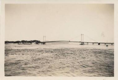 Phillip Island and District Historical Society Inc.
Photograph, 1940
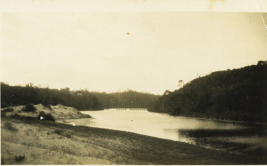
Taken by Miss Edith Elms 1940 and donated by her via Chrisy Northcote.Long distance view of Suspension Bridge 1940 showing long approach on right hand side with piers or jetties, middle background left.local history, photography, photographs, suspension bridge, san remo, phillip island, sepia photograph, bridges -
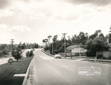 Eltham District Historical Society Inc
Photograph, Main Road, Eltham
Black and white photograph, looking from near Bridge street with D. Lyons house on right and the old Shire offices on the left in the distance.a.r warren, timber yard, bridge street, d lyons, houses, buildings, shire of eltham