Showing 1371 items
matching east side
-
 Ballarat Tramway Museum
Photograph - Black & White Photograph/s, Charles Rudd, c1890
... with buildings on the north east side of Sturt St. as well. Has a number... is travelling east to Grenville St. on the south side of Sturt St ...Black and white print from the State Library of Victoria, June 1999 of a horse tram crossing the intersection of Sturt and Lydiard Street Ballarat c1890. Tram is travelling east to Grenville St. on the south side of Sturt St. (wrong side these days). Has the Ballarat Post Office building in the background with buildings on the north east side of Sturt St. as well. Has a number of horse drawn cabs in photo and women in white clothing holding umbrellas over their head indicating a hot day. In the right hand side of the photo is the statue of poet Robert Burns. Has number "530" in the bottom left hand corner of photograph. State Library Multimedia Source Catalogue gives the photographer as Charles Rudd, 1849 to 1901, date of photo 1889-1891. Copy made Oct. 2001 for the "gold, Gold GOLD" temporary exhibition - colour laser print onto card, with Velcro dots on rear. Stored in box D1 (Display Box) 02/2003. State Library Permission required to reproduce the photo.On rear in pencil in bottom left hand corner "Copy of H39358/10" and in centre along bottom edge "Reproduction Rights Reserved - Copied by State Library of Victoria".trams, tramways, sturt st, lydiard st, horse trams, post office, two way traffic -
 Ballarat Tramway Museum
Slide - 35mm slide/s set of 7, Noel Simons, 1972
... destination of "Rly Station". Has buildings on the east side... on the east side of Mitchell St. in the background. 1212.3 - No. 7 ...Set of 7 transparencies undated on PAKON mounts - appear to be early 1970's. 1212.1 - No. 18 about to enter the Long Gully loop with ESSO service station on the right hand side. 1212.2 - No. 6 in Mitchell Street bound for Charing Cross. Tram has destination of "Rly Station". Has buildings on the east side of Mitchell St. in the background. 1212.3 - No. 7 (North Bendigo) and 29 (Golden Square) crossing. Actual location? 1212.4 - "No 6 showing 'SPECIAL' at Eaglehawk terminus. Has the Foodland store and Fruit shop in the background. 1212.5 - No. 19 at Eaglehawk terminus, on the extension to the normal Eaglehawk terminus. Tram has showing 'Eaglehawk'. Tram has two SEC roof ads. 1212.6 - No. 25 and another Bogie car at Quarry Hill terminus on last day. 1212.7 - No. 18 and 29 at Quarry Hill terminus. No.. 18 showing 'Quarry Hill' - has two SEC roof ads 'Electric Cooking - Matchless' and 'Everything's fine in my all electric kitchen' and No. 29 has a briquettes roof ad.Information typed onto a white label stuck on the slide. 1212.1 - "No. 18 at Long Gully" 1212.2 - "No. 6 in Mitchell Street." 1212.3 - "7 and 29 Lake View Hotel" 1212.4 - "No. 6 at Eaglehawk" 1212.5 - "No. 19 at Eaglehawk Term." 1212.6 - "Last cars Quarry Hill." 1212.7 - "18 & 29 Quarry Hill"tramways, trams, bendigo, long gully, mitchell st., eaglehawk, quarry hill, last tram, tram 6, tram 7, tram 18, tram 19, tram 25, tram 29 -
 Melbourne Tram Museum
Photograph - Set of 5 Black & White Photograph/s, Sutcliffe Pty Ltd, c1924
... of vehicles in the view. Looking south on the east side... with a number of vehicles in the view. Looking south on the east side ...Set of five Photographs, Black and White, of St Kilda Road, with works about to commence to convert the cable tram to electric trams. .1 - Overhead pole holes being dug in the one of the central plantations - pole and a Furphy water cart alongside. A cable tram is passing at speed. Note the scale of the houses opposite and the number of side walk superintendents! .2 - View of St Kilda Road with a few motor cars and one cable tram. Looking south on the Sth Melb. side. .3 - ditto, view of cable tram track, poles laid out on the central plantation, note the street lights. About seven cable trams in the view. Look south towards St Kilda Junction. The Junction hotel is in the view. .4 - similar photo, but further north. Cable trailer 74 in the view. .5 - View of St Kilda Road, vehicle road with a number of vehicles in the view. Looking south on the east side of the roadway. Photos Print and photograph by Sutcliffe of Cromwell buildings 366a Bourke St. Melbourne.In ink and pencil on the rear: .1 - "M&MTB H-60, Kew Depot `1920's (E45 in shed)" and the photographers stamp. .2 - "MMTB St Kilda Road about 1924" and in pencil "Tramway poles erected, pole not removed? Sth Melb side, looking south along motor track" .3 - As above - and in pencil - Tramway poles not erected - ????" .4 - As above with notes in pencil. .5 - As above with notes in pencil. About 1924 KSK print number SA932 to SA936.trams, tramways, st kilda rd, cable trams, conversion, trackwork, overhead, construction, tram 74 -
 Bendigo Historical Society Inc.
Document - LONG GULLY HISTORY GROUP COLLECTION: PART OF SANDHURST ROLL
... street by street and also listed East or West side or North... and occupation. Names are listed street by street and also listed East ...Copies of part of the Sandhurst Roll approx 1850's. Copies of pages 23, 24, 31, 32, 33, 34, 37, 38, 51, 52, 53 and 54. Pages contain the name of the resident and occupation. Names are listed street by street and also listed East or West side or North or South side.bendigo, history, long gully history group, the long gully history group - part of sandhurst roll -
 Port Melbourne Historical & Preservation Society
Photograph - Various photos related to John James GILCHRIST, John Gilcrist, 1940s - 1950s
... .12 - Photo of Edwards Park .13 - East side of house at 16... McCormack Street .12 - Photo of Edwards Park .13 - East side ...From John Gilcrist via Janet Bolitho13 photos from John GILCHRIST showing his father, John James GILCHRIST, at Station Pier and Princes Pier, a view from the Shrine of Remembrance, Centenary Bridge, and his father and mother, Eileen Mary GILCHRIST at their home at 16 McCormack Street Port Melbourne .01 - Princes Pier, Taroona, Port Hobart .02 - View from Shrine overlooking Albert Park Lake .03 - Between piers .04 - Princes Pier at night .05 - From Station Pier West finger pier .06 - House at 16 McCormack Street. (No. 12 McCormack Street also shown) .07 - Centenary Bridge1949-50 .08 - Outside 16 McCormack Street, showing Singer car. (Nos. 22, 24 & 26 McCormack Street also shown) .09 - John and Eileen Gilcrist in backyard .10 - South side of house at 16 McCormack Street .11 - South side of house at 16 McCormack Street .12 - Photo of Edwards Park .13 - East side of house at 16 McCormack Street Refer also to hand drawn plan of house and outbuildings at catalogue no. 2763piers and wharves - station pier, piers and wharves - princes pier, built environment, transport - roads, mccormack street, john gilchrist, john james gilchrist, mary eileen gilchrist -
 Bendigo Historical Society Inc.
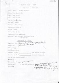
Document - DIAMOND HILL RESIDENTS 1955 AND 1920'S
... road. Brookfield lived in the big storehouse on the east side.... Brookfield lived in the big storehouse on the east side of the road ...BHS CollectionTyped 2 page document detailing the residents who lived at Diamond Hill in late 1920's, 1955 and 1981. Names include: Bush, James, market gardener Busyh, Mrs Elizabeth Day, Mrs Ellen Guild, Mrs Dorothy Holiday, James, Hocking, Mrs Rebecca Richards, David H Riley, James, Rower, Miss Sopghie Rushmeyer, Mrs Gertrude Weseloh, Mrs Augusta, Post Mistress Residents in 1920's Ändrews, Mary 9grandmother of Mrs Crawford, McIvor Road, Tweo sisters and their brother are Bill Rowe and ophy Rower. Le Clare, Miss Deason, Zephyr Mulqueen,Mrs Peter, Deason, Leaflet, Mulqueen, Mrs Ruityh Mrs and Miss Mabel Budgte Bidstrip Teasedale, Brookfield, Schrunck Andy Brookfield lived in the tent on the new road. Brookfield lived in the big storehouse on the east side of the road Dempster Bush Herbel, Miss Rose ( Mrs Luke Murphy) Dean, Herman Erwin, Andy Holidays ( 3 families) Wescloh, ( partly indecipherable) Augusta ( post mistress) Mrs Day Schilling, Roy Rushmeyer. (Ruschmeyer) 1981: Bush Rushmeyerbendigo, mining, diamond hill -
 The Beechworth Burke Museum
Photograph, 1960s
... and is a view across the lake from the east side, the photo was taken... and is a view across the lake from the east side, the photo was taken ...This photograph was taken in the 1960s at Lake Sambell and is a view across the lake from the east side, the photo was taken during a period of improvements to the lake and surrounding area. Lake Sambell is an artificial lake that was created on the site of the old Rocky Mountain Mining Company workings and was officially opened by Minister for Lands, Mr Baily, on October 5, 1928. The disused and unattractive remains of the mine were converted into a recreational area intended for swimming, boating, and fishing. The lake is named after Mr L.H. Sambell, shire engineer and secretary of the Forward Beechworth Committee, who advocated for the enhancement of Beechworth into a tourist destination and was central to the planning and establishment of the lake. Funding for the project was raised through both competition funds and donations. Since the construction in 1928 several engineering issues have arisen. In 1939 the water levels were low, and the lake was considered both an eyesore and ‘mudhole’, Beechworth Shire Council sort funding to raise the height of the lake six feet to improve the quality of water. Throughout the 1940s the Beechworth Swimming Club sort to address the structural engineering issues and improve swimming facilities at the lake. R.E. Carter, similar to L.H. Sambell, was a shire engineer who advocated the importance of positioning Beechworth as a tourist destination. Carter held the position of shire engineer from 1954-63 and organised many improvements to the Lake Sambell area including the caravan park in 1959, the lake swimming pool in 1961, water skiing and boating facilities, and increased the lake surface area in 1964. These improvements to the lake also reflect an increase in leisure time and access to travel during a period of post-war prosperity in Australia during the 1950s and 60s. This photograph is of historical significance as it documents Lake Sambell in the 1960s after a series of enhancements to the lake area to improve its appearance and usability for both the people of Beechworth and tourists. It is also of social significance in providing an insight into the increase in leisure time and access to travel during a period of post-war prosperity. Black and white rectangle photograph printed on photographic paper and unmounted.Reverse: 3534 C798lake sambell, l.h. sambell, r.e. carter, rocky mountain mining company, forward beechworth committee, beechworth swimming club, wallace park lake sambell development scheme, lake sambell caravan park, beechworth 1960s, lake sambell swimming pool, lake sambell boating, lake sambell fishing, swimming, boating, water skiing, fishing, post-war prosperity, minister of lands, artificial lake, open cut sluice mine, lake -
 Ringwood and District Historical Society
Photograph, Maroondah Highway East, Ringwood- 1870. Sandy Creek, now Ringwood Lake
... below large photograph: "Main St looking east. Right hand side... at Ringwood" Typed below large photograph: "Main St looking east ...3 photographs (2 large black and white, 2 small- 1 black and white, 1 sepia) Written on all photographs, "View at Ringwood" Typed below large photograph: "Main St looking east. Right hand side of gully now Ringwood Lake. Written on back of sepia print: "1870, Sandy Creek now Ringwood Lake" -
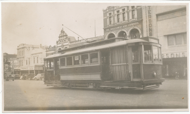
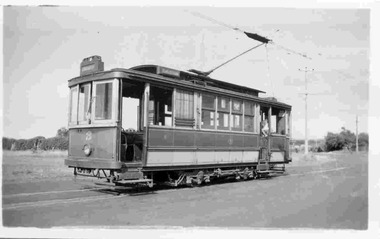
 Ballarat Tramway Museum
Photograph - Black & White Photograph/s, George Netherway, 1937
... , south side, east of Lydiard St. Has tram, overhead truck... in Sturt St, south side, east of Lydiard St. Has tram, overhead ...Copy photograph of a small photograph contained within item Reg. No. 587. Photograph showing track relaying in Sturt St, south side, east of Lydiard St. Has tram, overhead truck and compressor? working off overhead in photograph. Shows buildings in Sturt St. in background. Caption on 587 is "Lower Sturt St. S.side"trams, tramways, ballarat, rehabilitation, sturt st. -
 Ballarat Tramway Museum
Photograph - Digital image, 11/04/1944 12:00:00 AM
... of a photograph of No. 23 in Sturt St parking loop south side east end... Ballarat tram No. 23 in 1944 and the Sturt St east end south side ...Yields information about Ballarat tram No. 23 in 1944 and the Sturt St east end south side streetscape.Digital image from the Wal Jack Ballarat Album of a photograph of No. 23 in Sturt St parking loop south side east end with the Paterson's store, Ballarat Gas Co and Thomas' Tarax bar in the background. On the left hand edge is the tower truck. Dated 11-4-1944. See image i2 for rear of photograph. On rear of photograph in ink "Ballarat Tramways No. 23 (ex Adelaide "A" 69) on parking loop, Sturt St Ballarat 11-4-44" and "R. Pearson Photo" in bottom right hand corner.trams, tramways, sturt st, city loop, tram 23 -
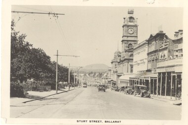
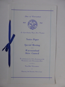 Warrnambool and District Historical Society Inc.
Document, Collett and Bain, Notice of meeting Warrnambool Shire, 1963
... . The Warrnambool shire covers the area on north east and western sides... the area on north east and western sides of the city of Warrnambool ...This booklet commemorates the 100th anniversary of the proclamation of the Shire of Warrnambool. The original proclamation was read from the Government gazette 13/12/1863 Pg 2958. This follows from being proclaimed a roads district in 1854 which was then partly portioned and proclaimed the Municipal district in 1855. Portion of the shire was again annexed to the city in 1955. The Warrnambool shire covers the area on north east and western sides of the city of Warrnambool covering approximately 600 square miles and has a rich history of farming and dairy products. A program which commemorates 100 years of the shire of Warrnambool. It contains a comprehensive list of councillors who served during that time.White light card cover with royal blue text and tied with royal blue ribbon.Pale blue vertical lines. Shire crest with dates either side at top centre of page.Back cover has list of councillors names who have served from 1863 up to 1963. Photographs in green tinge inside front and back covers. 8 pages. Cr Cyril Geoffery Boyle. Thursday 12th December 1963.Mr Robert Burke, Cr C S Brown, Cr C G Boyle, A F Ponting,The Honourable Murray Porter, Hon R W Mack, Cr J Pascoe, Mr J W Crawley, Mr L Crawley, J Wm Crawley, Jnr, R L Crawleywarrnambool,, warrnambool shire, cr c g boyle, warrnambool shire 1863, warrnambool shire 1963 -
 Eltham District Historical Society Inc
Photograph, Fay Bridge, Remains of apple orchard near the Diamond Creek, Wattle Glen, 11 October 2018
... on the VHD page) and the barn walls are on the north and to the east... on the VHD page) and the barn walls are on the north and to the east ...The newly constructed Diamond Creek Trail from Diamond Creek to Wattle Glen completed in February 2021 winds past these apple trees that possibly lined the entrance to the Greenhills property From Jean Verso, Nillumbik Historical Society, 15 April 2021 William Wandless Herbert bought the surrounding 100 acres in 1852. He was a native of Northumberland and the Scottish Borders who arrived in Melbourne in 1847. The house on the top of the mound would have been built not long after he bought the land; the farm was named "Greenhills". He married Elizabeth Wilson, daughter of John Wilson who had been in Diamond Creek since about 1846. Their first child was born in 1854 so there would be some form of dwelling from about that time. They had eight children who all survived to a good age. His will describes the house as part stone and part wood and of four rooms. Nillumbik Historical Society (NHS) believe it was one of the earliest if not the earliest house, in this part of the district. The remains of the stone house foundations are on top of the mound (photos on the VHD page) and the barn walls are on the north and to the east side of the mound. NHS is not sure how much or which part of the surrounding area was covered by the barns but they were large enough to hold dances after the race meetings that were held in the late 1880's on the adjacent creek flats. It would make sense with the lay of the land that they covered some of the ground to the north and east and used for farm storage, packing sheds for their apple and pear orchards and also for supporting the Nillumbik Gold Mine the family worked to the north up the gully. The path that comes down the gully and runs into the trail goes past the mine site which was on the west side of the gully a couple of hundred metres up from the flats. Heritage Victoria link for the site - https://vhd.heritagecouncil.vic.gov.au/places/12203fay bridge collection, 2018-10-11, diamond creek, diamond creek trail, elizabeth wilson, greenhills, wattle glen, william wandless herbert, apple trees -
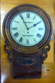 Kew Historical Society Inc
Functional object, H Newman, Boxed Wall Clock, 19th Century
... and watchmaker. East side between Denmark Street and Cotham Road. ... and watchmaker. East side between Denmark Street and Cotham Road. roy ...DEATH OF MR. H. NEWMAN. Widespread regret will be felt at the announcement of the death of Mr Henry Newman, an old colonist and a member of firm of Newman and Sons Proprietary Limited, jewellers, which occurred at his residence, "Sadova," William street, on Saturday, at the age of 89 years. Mr Newman who was born at Riga, in Russia, went to England when a lad, became naturalised, and emigrated to Victoria 61 years ago. He tried his fortune at Ballarat but soon afterwards returned to Melbourne, and began business as a jeweller, on a site in Collins street that is now occupied by Scott's Hotel. A few years later Mr Newman went back to England, where he was married. On his return to Victoria again he resumed his jewellery business in Elizabeth street opposite the General Post-office. An interesting fact in connection with his business is that his first journeyman watchmaker was Mr. Thomas Gaunt, the founder of the firm of Messrs. T. Gaunt & Co. Five years ago Mr. Newman retired from the business, which has since been carried on by his two elder sons. Although he took no active part in public affairs, Mr Newman was held in high regard on account of his business integrity, sterling personal worth. and the unostentatious way in which he did good. His vitality, even in his later years, was wonderful. On four occasions he met with accidents, having been twice knocked down by motorcars and twice by trams, without having sustained injury. A widow and grown up family of four sons and four daughters survive him. The Age Monday 27 October 1913, page 9. Roy Cronin 156 High Street Kew Jeweller and watchmaker. East side between Denmark Street and Cotham Road. Wood, enamel, brass and glass wall clock, the movement made by H Newman of Collins Street, Melbourne. A small label on the interior records the name R. Cronin, 156 High St, Kew, 1/7/20. It is unclear whether Cronin, a watchmaker and jeweller may have repaired or sold the clock. The clock (broken) is housed in a steel box.roy cronin - watchmaker - jeweller - kew (vic), h newman - melbourne (vic) - collins street - jeweller - clockmaker -
 Melton City Libraries
Photograph, Denominational Church and School, Unknown
... Denominational Church and School on the east side of Sherwin Street... Denominational Church and School on the east side of Sherwin Street ...Presbyterian Church Melton Background: A Combined Denominational Church and School was established in Melton by Protestants from the Presbyterian, Episcopalian, Wesleyan and Baptists denominations. A wooden church was built on the flat area east of the Toolam Toolern Creek. A photo of this church shows the buildings with small houses nearby. In the background the bluestone Presbyterian Church built in 1867 can be seen to the north on Yuille and Sherwin street. The flat area beside the road to Ballarat was subject to flooding and the site was eventually abandoned for a settlement. By the latter part of the 1860s the Church of England and Wesleyan bluestone churches were also being erected in the centre of the township of Melton. The commercial centre developed in High Street from Smith to Palmerston Street. Township of Melton Crown Grants Issued Under Common Law refers to the site of the Combined Denominational Church and School on the east side of Sherwin Street on the corner of Pyke Street. Section 4 Allotments 1 and 10 situated on the corner of Pyke, Bryan and Sherwin Street. The early map has the name of Thomas Cridge on this site. The area known Common (flat) remained open level ground with some cottages and buildings and a milk cooler in the 1930s, Granny Watts house “Lynch Cottage was moved in 1964. Sherwin Street was used until the 1960s with the open area being the used for playing golf. Alterations to the flat occurred when the golf course added to the height and removed the Sherwin Street access. The greens were developed and the height of ground altered the vista across Common. The first Presbyterian Minister in the district was the Reverend Alexander McNicol an advanced student and an experienced missionary from Glasgow, arriving in Melbourne in 1850. He was ordained on the 8th of June and was called to the Bacchus Marsh and Mount Macedon district. On the 1st of May 1851 he was called to Geelong and returned to Bacchus Marsh on February 1856 remaining until July 1859. Group of people in front of the church and school.churches, local identities, education -
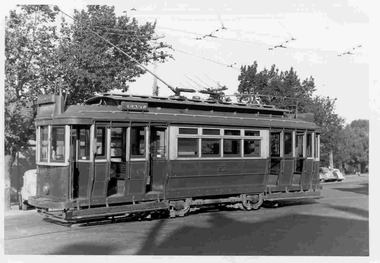 Ballarat Tramway Museum
Photograph - Black & White Photograph/s, Keith Kings, 7/01/1956 12:00:00 AM
... destination of "East" on the side. Keith Kings No. Q(u)(8... destination of "East" on the side. Keith Kings No. Q(u)(8 ...Black and White photograph contained with Reg. Item 1902 - Photo Album from Keith Kings to Les Denmead 1970. Photograph of SEC Geelong, No 23 outside the depot, 7/1/1956. Tram has destination of "East" on the side. Keith Kings No. Q(u)(8) Scanning: i - image file, p - presentation file, b - back of photograph.Stamp in top left hand corner and handwritten number with "K.S. Kings No. Q(u)(8) Copyright reserved". In blue ink "Geelong / No. 23, "unaltered" Pengelley car / outside Depot / 7/1/56".trams, tramways, geelong, depot, tram 23 -
 Ballarat Tramway Museum
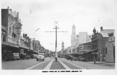
Postcard, Murray Views, "Murray Views No. 27 Ryrie Street Geelong Vic", early 1950s
... looking east from the west side of Yarra Street. A tram can... looking east from the west side of Yarra Street. A tram can ...Postcard produced by Murray View of Gympie, of Ryrie St looking east from the west side of Yarra Street. A tram can be seen turning at Moorabool St. In the view are the Geelong Theatre, Cox, the T&G building, Preston Hotel and H F Richardson live stock sale and a taxis sign. Also shows the wood centre of the road poles.Yields information about the view of Moorabool St at Ryrie St early 1950s.Black and white Postcard divided back, unused. Card No. 27tramways, trams, geelong, ryrie st -
 Eltham District Historical Society Inc
Photograph, Fay Bridge, Ruins beside the Diamond Creek at Wattle Glen, 13 October 2016
... and to the east side of the mound. NHS is not sure how much or which part... and to the east side of the mound. NHS is not sure how much or which part ...The newly constructed Diamond Creek Trail from Diamond Creek to Wattle Glen completed in February 2021 winds around these ruins just pass the high transmission power lines near Herberts Lane and Collard Drive From Jean Verso, Nillumbik Historical Society, 15 April 2021 William Wandless Herbert bought the surrounding 100 acres in 1852. He was a native of Northumberland and the Scottish Borders who arrived in Melbourne in 1847. The house on the top of the mound would have been built not long after he bought the land; the farm was named "Greenhills". He married Elizabeth Wilson, daughter of John Wilson who had been in Diamond Creek since about 1846. Their first child was born in 1854 so there would be some form of dwelling from about that time. They had eight children who all survived to a good age. His will describes the house as part stone and part wood and of four rooms. Nillumbik Historical Society (NHS) believe it was one of the earliest if not the earliest house, in this part of the district. The remains of the stone house foundations are on top of the mound (photos on the VHD page) and the barn walls are on the north and to the east side of the mound. NHS is not sure how much or which part of the surrounding area was covered by the barns but they were large enough to hold dances after the race meetings that were held in the late 1880's on the adjacent creek flats. It would make sense with the lay of the land that they covered some of the ground to the north and east and used for farm storage, packing sheds for their apple and pear orchards and also for supporting the Nillumbik Gold Mine the family worked to the north up the gully. The path that comes down the gully and runs into the trail goes past the mine site which was on the west side of the gully a couple of hundred metres up from the flats. Heritage Victoria link for the site - https://vhd.heritagecouncil.vic.gov.au/places/12203fay bridge collection, 2016-10-13, diamond creek, diamond creek trail, ruins, wattle glen, william wandless herbert, greenhills, elizabeth wilson -
 Ballarat Tramway Museum
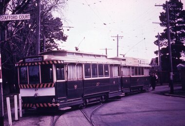
Slide - 35mm slide/s - set of 7, Noel Simons, 1970's
... St. Shows the retaining wall for the cutting on the east... St. Shows the retaining wall for the cutting on the east side ...Set of 7 transparencies taken undated (appear to be 1970 or 71) on PAKON mounts. Also possibly copy slides as quality is poorish. 1175.1 - No. 27 has derailed at Depot, across Wendouree Parade, and No. 33 appears to be about to try and tow it back on. Wendouree Parade totally blocked. Adjacent pole has tram stop sign and has "Stafford Court" street sign mounted on it. 1175.2 - No. 43 at corner of Drummond St. South and Dana Street, with destination Lydiard St. North. 1175.3 - No. 42 (Mt Pleasant) and 21 (Gardens via Sturt St. West) crossing at Gardens Loop. 1175.4 - No. 42 bound for Lydiard St. Nth at intersection with Macarthur St. Shows the retaining wall for the cutting on the east side of Lydiard St. Nth. 1175.5 - No. 43 at corner of Lydiard St and Sturt St., at city terminus showing "Special" and tram 35 adjacent to Post Office in Lydiard St. Nth. Photo shows the small tram stop pole at this location and Post Office building. 1175.6 - No. 39 and 26 and 27 at the Mt Pleasant terminus. Near closure as a bus stop sign has been positioned on the west side of the road. No. 39 showing destination of "Gardens via Sturt St. West" 1175.7 - Nos 21 and 34 crossing at the Grant St. loop in Barkly St. 21 has destination of Mt Pleasant, while 34, - Gardens via Sturt St. West"All information on typed small white labels, on the top of the slides using black ink. 1175.1 - "27 derailed and 33 at depot" 1175.2 - "43 at cnr Drummond & Dana Sts" 1175.3 - "21 and 42 Gardens Terminus" 1175.4 - "42 at cnr Macarthur & Lydiard" 1175.5 - "43 & 35 at Post Office" 1175.6 - "39, 26 and 27 at Mt Pleasant" 1175.7 - "21 & 34 at Grant St"tramways, trams, wendouree parade, depot, accidents, derailments, drummond st. sth, gardens loop, post office, mt pleasant, grant st., tram 21, tram 26, tram 27, tram 33, tram 35, tram 42, tram 43 -
 Ballarat Tramway Museum
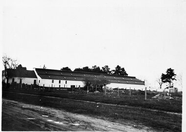
Photograph - B&W print of donated negative - set of 5, State Electricity Commission of Victoria (SECV), c1936
... . on the western side. Shows the whole length of the buildings. 1350.2.... 1350.5 - Office, lockers etc. buildings on east side of depot ...Yields information about the depot and environs during the reconstruction of the Ballarat tramways and the vacant land to the west of the depotSet of 5 Black and white photo prints from collected negatives of the SEC Ballarat depot building, during refurbishment by the SEC during the mid 1935/1936, taken at the same time as Reg Item 1349. 1350.1 - Depot buildings from Gregory St. on the western side. Shows the whole length of the buildings. 1350.2 - Western side of depot buildings from Gregory St. end, looking towards Wendouree Parade. 1350.3 - Eastern side of depot building from Gregory St. end. 1350.4 - Western side of depot building from Wendouree Parade - shows yard on side which was to become the tennis court. 1350.5 - Office, lockers etc. buildings on east side of depot, from Wendouree Parade, Shows the 'Bundy' clock. A motor bike is parked against the wall. 2nd copy held of 1350.1, 1350.2 and 1350.3 - ex moveable display boards. Colour photocopies laminated of these photographs on display 6/2000 at 02-02-06. Copy 3 - of all above photos - large format prints (203H x 253W) - added 28/7/2007, ex Alan Bradley holding of prints, received 5/2007. See also Reg Item 3902 for a mounted set of these photographs along with that of Reg Item. 1349. High res scans of negatives changed over 13/5/2020.tramways, trams, wendouree parade, sec depot, rehabilitation, depot offices -
 Ballarat Tramway Museum
Photograph - Black & White Photograph/s, Keith Kings, Feb. 1951
... destination of "Chilwell" at the front and "East" on the side... destination of "Chilwell" at the front and "East" on the side ...Black and White photograph contained with Reg. Item 1902 - Photo Album from Keith Kings to Les Denmead 1970. Photograph of SEC Geelong, No 3 at East terminus, Feb. 1951. Tram has destination of "Chilwell" at the front and "East" on the side. No buildings in the background of the photo. Keith Kings No. E(q)(3) Scanning: i - image file, p - presentation file, b - back of photograph.Stamp in top left hand corner and handwritten number with "K.S. Kings No. E(q)(3) Copyright reserved". In blue ink "Geelong / No. 3, as converted for "one-man" operation / East Terminus 2/51".trams, tramways, geelong, east, tram 3 -
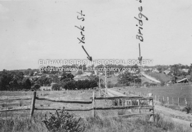 Eltham District Historical Society Inc
Album - Photograph, J.A. McDonald, Eltham-Diamond Creek Road, 21 Oct. 1953
... intersection of Silver Street at Brisbane Street looking east... intersection of Silver Street at Brisbane Street looking east ...Diamond Street Bridge 21st October, 1953 (showing York St., Bridge St., and Brisbane St in immediate foreground) View from intersection of Silver Street at Brisbane Street looking east. On the far side of Brisbane Street is the site of present-day Bunnings store. At the visible end of Brisbane Street where it turns right it then became Susan Street but today continues to the intersection with Bridge Street.Record of various Shire of Eltham infrastructure works undertaken during the period of 1952-1962 involving bridge and road reconstruction projects, sometimes with Eltham Shire Council Project Reference numbers quoted. It was during this period that a number of significant improvements were made to roads and new bridges constructed within the shire that remain in place as of present day (2022). In many situations, the photos provide a tangible visible record of infrastructure that existed throughout the early days of the Shire. The album was put together by or under the direction of the Shire Engineer, J.A. McDonald.infrastructure, road construction, shire of eltham, 1953-10-21, bridge construction, brisbane street, silver street, susan street, york street -
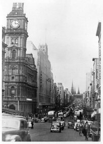 Melbourne Tram Museum
Photograph - Black and White - Bourke St early 1950s
... Photograph, from a publication, of Bourke St looking east... Photograph, from a publication, of Bourke St looking east from ...Photograph, from a publication, of Bourke St looking east from the south side between Queen and Elizabeth Streets. The cable tram tracks can be seen in the street pavement. Has many double deck and some single deck buses. Very busy and congested traffic scene between Elizabeth and Swanston Streets. In the view are the General Post Office, the Myer Store, Foys, Parliament House and London Stores.Yields information about Bourke Street prior to conversion to electric trams.Black and white photograph of Bourke St looking east early 1950'stramways, mmtb, buses, double deck buses, bourke street, cable trams, traffic -
 Ballarat Tramway Museum
Photograph - Digital image, 1930
... of a postcard - titled "Sturt St Ballarat", looking east along the south... Ballarat", looking east along the south side of Sturt St from ...Yields information the buildings, buildings and scene in Sturt St looking East from Doveton St.Digital image from the Wal Jack Ballarat Album of a postcard - titled "Sturt St Ballarat", looking east along the south side of Sturt St from Dawson St. Tram in the far distance. Has a number of motor vehicles in the photograph. No details of the manufacturer on the back of the photograph - see image i2.trams, tramways, esco, sturt st, dawson st -
 Ballarat Tramway Museum
Photograph - Colour Photograph/s - set of 25, Neville Gower, 7/02/1997 12:00:00 AM
... - Power pole east side of Ripon St North between Mair and Sturt... - ditto 1652.11 - Power pole east side of Ripon St North between ...Group of twenty five photographs taken on 7/2/1997 of some power poles around Ballarat that still carry the paintwork, faded and worn, of the SEC tramway system tram stops. 1652.1 - North East corner of Drummond Street South and Sebastopol St. 1652.2 - ditto 1652.3 - North east corner of Drummond St. South and La Trobe St. - with bus stop sign 1652.4 - ditto 1652.5 - North corner of Drummond St. South and Skipton St. 1652.6 - ditto 1652.7 - North east corner of Ripon St. North and Sturt St with King Chicken and Seafood shop in the background. 1652.8 - ditto looking down Sturt St. 1652.9 - South West corner of Ripon St. North and Sussex Streets 1652.10 - ditto 1652.11 - Power pole east side of Ripon St North between Mair and Sturt Streets 1652.12 - South west corner of Mair and Ripon North Streets 1652.13 - ditto 1652.14 - North East corner of Mair and Ripon Streets 1652.15 - ditto 1652.16 - ditto 1652.17 - North west corner of Burbank and Macarthur St 1652.18 - ditto 1652.19 - North east corner of Drummond St. North and Webster St. 1652.20 - ditto 1652.21 - Powerlines between Doveton and Dawson in Sturt St. 1652.22 - South corners of Sturt and Doveton Streets 1652.23 - ditto 1652.24 - ditto 1652.25 - ditto Negatives and envelope for the prints with the Reg Item 1652 sheet in documents folder. Photo folder with handwritten notes and negatives with Catalogue Worksheet.tram stops, drummond st., ripon st, sturt st -
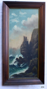 Flagstaff Hill Maritime Museum and Village
Painting - Oil painting, W. Langley-Taylor, Cape Schank [Schanck], Late 19th to early 20th century
... , which is on the east side of Port Phillip Bay. It includes..., Victoria, which is on the east side of Port Phillip Bay ...This painting is one of a pair of large paintings by W. Langley-Taylor in our collection. Currently, no further information has been found about the artist but research is ongoing. The subjects of these paintings are seascapes of notable areas of the coast on each side of Port Phillip Bay, south of Melbourne, Victoria. The subject of this painting is Cape Schanck, Victoria, which is on the east side of Port Phillip Bay. It includes the Cape Schanck Lighthouse and its Flagstaff. The Cape Schanck Lighthouse was built in 1859 and is the second of Victoria’s coastal lights. It is 21 metres tall and made from limestone. Unusually, its stairway is made from stone rather than wrought iron. Gilded tours are available to explain its use and significance to visitors. The lighthouse keepers at Cape Schanck kept records of the ships that sailed past them along Bass Strait; ship’s names, direction, time and date and so on. The details would also be passed on to shipping agencies, Harbour Masters and newspapers, which published Arrivals and Departures into and out of shipping ports such as Port Phillip Bay and the Port of Melbourne. INSCRIPTIONS “Mrs M Irby” (and on the Eagle Rock, Warrnambool, painting “980/Regency”) The inscription “Mrs M Irby” is on the back of both paintings but the significance of the inscription has not yet been discovered. Perhaps she was connected with the ship or shipping company “Irby”. A ship named “Irby”, built in Merseyside, Liverpool in 1881 by R & J Evans, Birkenhead. It was a four-masted iron ship built for the White Star Line. Henry Wilson Hewitt bought her in 1882, then later she was owned by Chadwick & Pritchard. In 1888 she was registered under the Irby Ship Co. Ltd. (trading as J. Joyce) in Liverpool. In 1912 Galgate Co. Ltd owned her. She traded between London, England and Australia, and is recorded as being in Melbourne and Hobart. In 1919 the Irby was destroyed by a mine when on her way to England. Or perhaps her name and the inscription in pencil “980/Regency” on the Eagle Rock Warrnambool, painting could be a delivery address for the paintings, perhaps an apartment in a hotel. NOTE: The artist’s spelling of the title “Cape Schank, Vic.” is incorrect. The location in this painting is named Cape Schanck. This painting is significant geographically for its representation of the coastal scenery of Victoria, Australia. It is also significant as one of a pair of paintings of seascape, one at sites each side of Port Phillip Bay. The painting is significant historically as an example of late 19th and early 20th methods and materials used to construct a painting’s frame. Painting oil on board in a dark wooden frame, portrait orientation. Seascape of coast with cliffs, lighthouse and flagstaff, flying birds, high waves breaking onto rocks, blue sky with clouds. The title is painted on lower left corner and the Victorian artist, W. Langley-Taylor, has signed his name on lower right. The inscription on back is handwritten script in red crayon or thick red pencil. The board is held in place inside the timber frame with small, dark metal tacks around all sides. Metal eyes join the wire to the frame. Small round, dark metal nail heads are dispersed around the frame and there is a change of colour on both the board and the wood of the frame. Painted on front “W.LANGLEY-TAYLOR.” and “CAPE SCHANK, VIC.” [NOTE: correct spelling is Schanck] Handwritten on back “Mrs. M. Irby” flagstaff hill, warrnambool, shipwrecked coast, flagstaff hill maritime museum, maritime museum, shipwreck coast, flagstaff hill maritime village, great ocean road, painting, oil painting, cape schanck painting, w. langley-taylor, wall decoration, seascape of victoria's coast, art, mrs m irby, victoria's coast, pair of paintings -
 Ruyton Girls' School
Photograph, Ruyton Girls' School, 1951
... , a dedicated Prefects Room was erected on the east side of the Ruyton..., a dedicated Prefects Room was erected on the east side of the Ruyton ...Depicted are four students who were the 1951 House Captains at Ruyton Girls' School. The photo is an official school portrait, taken outdoors in front of Henty House (formerly Tarring). In the background, we can see two bicycles. The girls are dressed in their school uniforms, comprising a knee-length check-print skirt, dark jumper, light-coloured collared buttoned blouse with a dark tie, wool blazer, stockings, and dark-coloured lace-up shoes. Two of the girls are standing, while the other two are seated on a small concrete plinth. The students have been identified, from left to right, as A. Dickinson (Lascelles), C. Kent (Anderson, H. Cole (Bromby), and E. Duff (Daniell). Student leadership commenced at Ruyton Girls' School in 1906 with the introduction of the prefect system. Prefects had numerous responsibilities—gate duty, grounds duty, classroom marking, assembly door watch, uniform monitoring, and even supervising student detention. In 1947, a dedicated Prefects Room was erected on the east side of the Ruyton Girls' School Assembly Room in Henty House. The prefects system was revised in 1968 with a new leadership structure: there would be a permanent School Captain, Vice Captain and School Sports Captain; six permanent prefects would be elected, and the rest of the Matriculation class would form committees. These included Library, Social Services, S.C.M., Editorial, and Music. In this way, it was thought "that each Matric girl would have a certain amount of responsibility." With this revised structure came a brand new Prefects' Study, located in a former classroom next to the Domestic Science building. Each prefect was allocated one book locker, one clothing locker, "a small share in the heater", plus a new shared lounge. The prefect system was updated again in 1974. All sixth formers would become prefects, or "school officials." This saw the sixth form divided into two halves: one group would be prefects for the first half of the year, then the second group would take the reigns in the latter half of the year. In October 2023, Ruyton announced a new collaborative leadership structure for captains, prefects and house leaders, which would see two students in each leadership role.The record has strong historic significance as it gives insight into the House system at Ruyton Girls' School. In the early 1920s, Ruyton was settling into its new home at Selbourne Road, Kew. At the time, students were arranged by their form (or year level) for lessons and other school activities. A collection of eight emblems and mottoes for each form group was published in the Ruytonian December 1922, although the genesis of each were left unexplained. With enrolments continually growing, Principal Miss Hilda Daniell felt a new basis of organisation would benefit students, giving them a broader outlook and something bigger to work for. She took inspiration from tradition and implemented a House system. The House system was adopted at Ruyton in September 1924 to "provide a new kind of co-operation and competition among the girls, especially in Sport." There were four houses, three of which were named after early Principals: Anderson, Bromby and Lascelles. There was also the School House, initially for boarders only. Some time after the publication of the Ruytonian in April 1928, the School House was renamed Daniell House, and had opened up to day girls. The account published by the newly formed Daniell House in the Ruytonian December 1928 reads, "we are rather bashful in presenting this account of our doings, for we are conscious of our newness. Our house has now the honour of being known as Daniell House." Four of the original eight form emblems were adopted by the new Houses, while the others were discarded. According to former teacher and author of the centenary history of Ruyton, Ms Majorie Theobald, the House system "gave a new focus for all competitive sport, which had previously been organised on a rather inequitable basis." The colours chosen for the Houses were cherry red for Anderson, royal blue for Bromby, gold for Lascelles, and pale blue for School (later Daniell). New students starting at Ruyton from Prep onwards are allocated to one of the Houses with consideration to family connections and balance of numbers. The record's significance is further enhanced by its strong provenance, having been produced by Ruyton Girls' School and donated to the Archives by a familial connection of a former notable student.Black and white rectangular photograph printed on matte photographic paper.Reverse: Caroline Kent / Mary Murray. / 11.12.51. / Ann Dickinson / RGS011/1951/0003ruyton girls' school, ruyton, students, school, senior school, girls school, kew, melbourne, school uniform, prefects, photograph, henry henty, henty house, marion henty, tarring -
 Eltham District Historical Society Inc
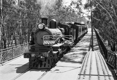
Photograph, VR Commissioner's Special train, steam locomotive D3-639 crossing the Echuca-Moama Road Rail Bridge over the Murray River from Moama, NSW to Echuca, Victoria, 1962
... pedestrian walkway was still on the east side at the time." "I... pedestrian walkway was still on the east side at the time." "I ...VR Commissioner's Special train, steam locomotive D3-639 crossing the Echuca-Moama Road Rail Bridge over the Murray River from Moama, NSW to Echuca, Victoria. Commissioner Edgar Henry Brownbill on footplate, 1962. Commissioner Edgar Henry Brownbill was in office 1957 to 1967. George Coop advises - "The train on the Eltham/Moama bridge is actually the Commissioner’s Special on one of its inspection tours of the VR rail system. This was a very grand special train with accommodation for the Commissioner and staff in carriages also used once for the Royal Train and other State purposes. You can just see the Commissioner of the day, dressed in his suit and wearing engine drivers gloves, standing in the loco cab doorway. A good ‘hands on’ impression is created amongst local staff if can be seen that the boss is no ‘desk jockjey’. The observation car on the back was originally made for the ’Spirit of Progress’. I climbed up onto the bridge iron plate work to get this view. It was safe enough as the cantilevered pedestrian walkway was still on the east side at the time." "I was resident in Echuca from Jan. ’59 to approx. May ’64. At that time the single Echuca/Moama bridge was a combined road/rail bridge. The rail gauge was 5’3” and still is, I believe, on the new bridge that sits just upstream of the old one. This rail line into NSW has always been 5’3" gauge because it has no connection with any NSW tracks. The old Echuca/Moama bridge, locally called the ‘Iron Bridge’ has, over years, undergone some structural changes. The two lattice iron hoops arcing over the roadway have been raised and lowered and changed design. Presently a pedestrian walkway is cantilevered off the west (or downstream) side of the bridge. It used to be on the eastern side. Guess changes went in when new rail bridge only was built on the eastern side as well." Image dated as c.1963 based on same image in Port of Echuca collection (possibly frame 32 of film) (print 19.5 x 24.5cm) On reverse in pencil: "Brown card" in black pen: "Commissioners special. F. Brown on Footplate. George C.L. Coop c1963". https://victoriancollections.net.au/items/59d575b921ea6e1278d78042 However based on frame no. 10, date set as 1962Digital TIFF file Scan of 35mm Ilford FP3 black and white negative transparencyd3-639, d3-class steam locomotive, echuca-moama road rail bridge, edgar henry brownbill, george coop collection, murray river, vr commissioner's special train -
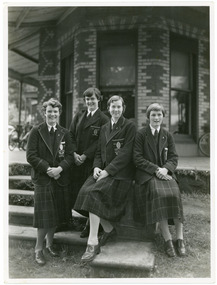
 Ruyton Girls' School
Photograph, Ruyton Girls' School, 1951
... was erected on the east side of the Ruyton Girls' School Assembly Room... was erected on the east side of the Ruyton Girls' School Assembly Room ...Depicted are nine Ruyton Girls' School prefects for the 1951 school year. The image is a formal school portrait taken outdoors on school grounds outside of Henty House (formerly Tarring). In the background, we can see three bicycles with cane baskets. The students are all dressed in knee-length check skirts, a dark jumper, light-coloured collared button-up blouse with a dark tie, wool blazers, and dark coloured shoes. Four girls are standing in the back row, and five are positioned in the front row. Students in the back row have been identified from left to right as M. Murray, B. Addison, T. Abson and H. Cole; in the front row, from left to right we can see S. Backhouse, J. Wigg (Vice Captain), F. Jacobs (Captain), E. Duff, and A. Dickinson. The same photograph appears in the Ruytonian 1951. Student leadership commenced at Ruyton Girls' School in 1906 with the introduction of the prefect system. Prefects had numerous responsibilities—gate duty, grounds duty, classroom marking, assembly door watch, uniform monitoring, and even supervising student detention. In 1947, a dedicated Prefects Room was erected on the east side of the Ruyton Girls' School Assembly Room in Henty House. The prefects system was revised in 1968 with a new leadership structure: there would be a permanent School Captain, Vice Captain and School Sports Captain; six permanent prefects would be elected, and the rest of the Matriculation class would form committees. These included Library, Social Services, S.C.M., Editorial, and Music. In this way, it was thought "that each Matric girl would have a certain amount of responsibility." With this revised structure came a brand new Prefects' Study, located in a former classroom next to the Domestic Science building. Each prefect was allocated one book locker, one clothing locker, "a small share in the heater", plus a new shared lounge. The prefect system was updated again in 1974. All sixth formers would become prefects, or "school officials." This saw the sixth form divided into two halves: one group would be prefects for the first half of the year, then the second group would take the reigns in the latter half of the year. In October 2023, Ruyton announced a new collaborative leadership structure for captains, prefects and house leaders, which would see two students in each leadership role.The record has strong historic significance as it depicts a former notable student, Helen Gordon (maiden name Cole), pictured third from the right in the front row. Helen started at Little Ruyton in Prep 1940 and finished Year 12 in 1952 as School Captain, Bromby Captain, Form Captain for Matric, Tennis Captain, Hockey Captain, Swimming Vice Captain, and an award for Best All-Round Girl. She also played baseball for Victoria. After finishing school, Helen went on to graduate from the University of Melbourne as a physiotherapist in 1956. Her first position at age 19 involved setting up clinics with the Victorian Health Department Poliomyelitis Rural division. Helen’s strong ties to Ruyton continued when she held the position of President of the Old Ruytonians’ Association from the start of 1966 to the end of 1967. In 2019, Helen received an Order of Australia Medal for service to community health as a physiotherapist. She was also the recipient of the 2022 Victorian Senior Achiever Award at Parliament House. Helen passed away in July 2023 at age 88. The record's significance is further enhanced by its strong provenance, having been produced by Ruyton Girls' School and donated to the Archives by a familial connection.Black and white rectangular photograph printed on matte photographic paper.Reverse: Felicity Jacobs / Judi Olsen / Ann Dickinson / Bev. Addison / RGS011/1951/0004 /ruyton girls' school, ruyton, students, school, senior school, girls school, kew, melbourne, school uniform, prefects, photograph, henry henty, henty house, marion henty, tarring -
 Whitehorse Historical Society Inc.
Photograph, Whitehorse Road, Mitcham, 2000
... East along North side of Whitehorse Road towards Mitcham Road... and white photograph - print and negative looking East along North ...Produced as one of a series of 24 prints commissioned by Nunawading & District Historical Society -|Theme: Intersections of Mitcham and Nunawading 2000/2001.|See also Series by P. Simmenauer on the same theme. Black and white photograph - print and negative looking East along North side of Whitehorse Road towards Mitcham Road intersection from corner of Station Street. Featured from L-R shops include Stan Russell Mens Clothing; Top floor Wing Chum Kung Fu Academy (Martial Art); Lower floor: Florist, Bryson Office Supplies, Mitcham Pharmacy and Medical Centre; Road sign - Mitcham Road - Vermont; across intersection - sign for 'Bristol Paints'.whitehorse road, mitcham, stan russell menswear, wing chum kung fu academy, florists, mitcham pharmacy, mitcham medical centre, bristol paints, bryson office supplies -
 Ballarat Tramway Museum
Newspaper, The Courier Ballarat, "Digging deep", 23/03/1972 12:00:00 AM
... in Sturt St. Photo taken looking east along the south side... in Sturt St. Photo taken looking east along the south side ...Newspaper clipping from The Courier, Ballarat, Thursday 23/3/1972 titled "Digging deep" with a photo showing the excavation of the former tram lines near the Drummond St intersection in Sturt St. Photo taken looking east along the south side of Drummond St. One of a large group of newspaper cuttings from John Bainbridge, 7/4/02.track removal, tram track removal, crb, sturt st