Showing 3482 items
matching english.
-
 Moorabbin Air Museum
Photograph (Item) - Folder of photographs of English Electric Canberra B3/45 aircraft airframe components Book 2 of 2
-
 Bayside Gallery - Bayside City Council Art & Heritage Collection
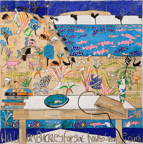
Painting - gouache, charcoal and book spines on collaged book pages on linen, Katherine Hattam, William Buckley forgot how to speak English, 2018-19
-
Moorabbin Air Museum
Book - History and photos of English Electric Aircraft and their predecessors, English Electric Aircraft and their predecessors, 1987
History and photos of English Electric Aircraft and their predecessorsJacket with Lightning jet and blue sky backgroundnon-fictionHistory and photos of English Electric Aircraft and their predecessors -
Moorabbin Air Museum
Model (Item) - Canberra Bomber [English Electric] scale 1:98
-
![Book, The Cambridge Australian English Style Guide / [by] Pam Peters, 1995](/media/collectors/550653872162f11fb04854aa/items/5d03421121ea7b0950474999/item-media/5d03423121ea7b0950478532/item-fit-380x285.jpg) Kew Historical Society Inc
Kew Historical Society IncBook, The Cambridge Australian English Style Guide / [by] Pam Peters, 1995
xiii, 848 penglish language - australia - style, writing - handbooks, english language - australia - usage -
![An account of the English colony in New South Wales : with remarks on the dispositions, customs, manners, &c. of the native inhabitants of that country, to which are added, some particulars of New Zealand / compiled, by permission, from the Mss. of Lieutenant-Governor King by David Collins [Volume 1]](/media/collectors/550653872162f11fb04854aa/items/575ba01ad0cdd1229c1f675d/item-media/57600f26d0cdd11990766530/item-fit-380x285.jpg) Kew Historical Society Inc
Kew Historical Society IncBook, State Libraries of South Australia, An account of the English colony in New South Wales : with remarks on the dispositions, customs, manners, &c. of the native inhabitants of that country, to which are added, some particulars of New Zealand (Vol.1), 1971
[Adelaide : Libraries Board of South Australia, 1971] 2 v. : maps (part col.), plates (part col.) ; 28 cm. Facsimile of: London : T. Cadell jun. and W. Davies, 1798. Includes an account of a voyage performed by Captain Flinders and Mr. Bass abstracted from the journal of Mr. Bass. Volume 1non-fictionnew south wales - descriptions and travel, new zealand - descriptions and travel -
![An account of the English colony in New South Wales : with remarks on the dispositions, customs, manners, &c. of the native inhabitants of that country, to which are added, some particulars of New Zealand / compiled, by permission, from the Mss. of Lieutenant-Governor King by David Collins [Volume 2]](/media/collectors/550653872162f11fb04854aa/items/575ba131d0cdd1229c1ff2b1/item-media/57600fbed0cdd1199076abab/item-fit-380x285.jpg) Kew Historical Society Inc
Kew Historical Society IncBook, Libraries Board of South Australia, An account of the English colony in New South Wales : with remarks on the dispositions, customs, manners, &c. of the native inhabitants of that country, to which are added, some particulars of New Zealand (Vol. 2)], 1971
[Adelaide : Libraries Board of South Australia, 1971] 2 v. : maps (part col.), plates (part col.) ; 28 cm. Australian Facsimile Editions No.76. Volume 2non-fictionnew south wales - descriptions and travel, new zealand - descriptions and travel -
RMIT GSBL Justice Smith Collection
Report, Legislation, legal rights and plain english, 1986
Discussion paper no. 1 August 1986ISBN: 0724142894law -- victoria -- language, legislation -- victoria, legal instruments -- victoria -
RMIT GSBL Justice Smith Collection
Report, Plain English and the law : report, 1987
Report volume only Report no. 9 Reprint 1990ISBN: 0724165616law -- victoria -- language, law -- language, bill drafting, legal composition -
 RMIT GSBL Justice Smith Collection
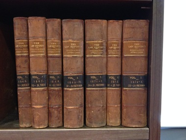
Journal series, Clark, C, The law reports : English and Irish appeal cases and claims of peerage before the House of Lords, 1866
Previous owners: T. H. Smith, T. W. SmithNo. of volumes: 7 Volume range: Vol. 1 (1866) - Vol. 7 (1874-1875) law reports; digests; etc. -- great britain, nobility -- claims, appellate procedure -- great britain -- cases -
RMIT GSBL Justice Smith Collection
Book, Guest, Anthony Gordon, Principles of the English law of contract and of agency in its relation to contract, 1959
Twenty-first editioncontracts, contracts -- great britain, agency (law) -- great britain -
RMIT GSBL Justice Smith Collection
Book, Stallybrass, W.T.S, Salmond's law of torts a treatise on the English law of liability for civil injuries, 1945
Previous owners: T. H. Smith, T. W. SmithTenth editiontorts -- great britain -
RMIT GSBL Justice Smith Collection
Book, Hall, Lacelot Edey, Possessory liens in English law, 1917
liens -- great britain -
RMIT GSBL Justice Smith Collection
Book, The Law Book Co. of Australasia Pty Ltd, Victorian company law and practice comprising the Companies Act 1983 (with which is incorporated the Companies Act 1983), comparative tables in regards to English, Australian (State) and New Zealand acts, annotations and explanations, together with regulations and forms, 1940
Previous owners: T. H. Smith, T. W. SmithFirst editioncorporation law -- victoria -
 Freemasons Victoria - Gordon Lodge, 99
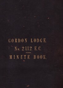
First Minute Book - Gordon Lodge 2112 E.C. (English Constitution)
The first Minute Book of the Gordon Lodge, which starts with the first meeting of local Freemasons desirous of founding a new lodge in the Essendon area was held at the Ascot Vale Hotel in July 1885. William Farquharson Lamonby was the driving force, financier and founder of the Gordon Lodge and when he wasn't present not a lot happened at those Ascot Vale Hotel meetings. -
Kew Historical Society Inc
Book, Brooke, Iris, English Children's Costume Since 1775, 1965
non-fictionchildren -- costume, costume -- great britain -
 Expression Australia
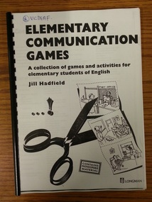
Book, Elementary Communication Games, A collection of games and activities for elementary students of English
By Jill Hadfield29.5cmHx21.5cmW, 96 pages -
 Heidelberg Theatre Company Inc..
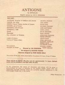
Program Photos Article, Antigone by Sophocles english version by Ian H. Robinson directed by Ian Robinson
1979, 193, heidelberg theatre company inc, directed by ian robinson -
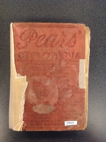 Stawell Historical Society Inc
Book, R. Clay & Sons - Great Britain, Pears Dictionary of the English Language
Mrs Florence Tangeystawell education -
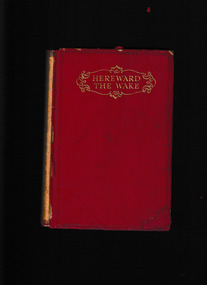 Mrs Aeneas Gunn Memorial Library
McMillan, Hereward the Wake : "Last of the English", 1928
Tells the story of Hereward, a historical Anglo-Saxon figure who led resistance against the Normans from a base in Ely surrounded by fen land.p.373.fictionTells the story of Hereward, a historical Anglo-Saxon figure who led resistance against the Normans from a base in Ely surrounded by fen land.england - fiction, norman england -
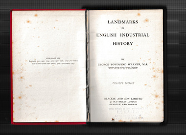 Mrs Aeneas Gunn Memorial Library
Book, Blackie, Landmarks in English industrial history, 1913
An economic history of Britain from the Norman times.Index, p.368.non-fictionAn economic history of Britain from the Norman times.great britain - economic history, industrial revolution -
 Mrs Aeneas Gunn Memorial Library
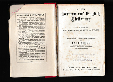
Book, A New German and English dictionary / compiled from the best authorities in both languages ; revised and considerably enlarge, 1909
A German, English dictionaryp.797., p.545 .non-fictionA German, English dictionarygerman language - dictionaries, english language - dictionaries -
 Mrs Aeneas Gunn Memorial Library
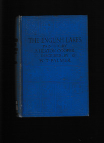
Book, A. and C. Black, The English lakes, 1925
A description of the English lakesIndex, ill, map, p.230.non-fictionA description of the English lakes english lakes - description, english lakes - travel -
 Mrs Aeneas Gunn Memorial Library
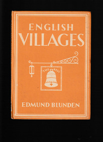
Book, Collins, English villages, 1942
An illustrated guide to English villagesIll, p.48.non-fictionAn illustrated guide to English villagesvillages - england, england - description and travel -
 Kilmore Historical Society
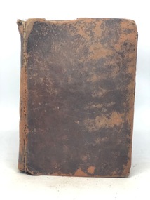
POCKET-DICTIONARY ENGLISH AND GERMAN, The New Pocket-Dictionary of the English and German Languages, 1800
Faded brown leather cover with damage to edges vi; 395 pages; 15cm Handwritten inscription on first page 'J Thorpe'kilmore mechanics institute library. -
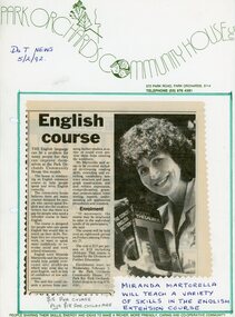 Park Orchards Community House
Photograph, English course at Park Orchards Community House, with Miranda Martorella. Doncaster and Templestowe News 5 February 1992
Unknown year -
Thompson's Foundry Band Inc. (Castlemaine)
Sheet Music, English Maiden, The
-
Thompson's Foundry Band Inc. (Castlemaine)
Sheet Music, Savoy English Medley
-
Thompson's Foundry Band Inc. (Castlemaine)
Sheet Music, Three English Pieces
-
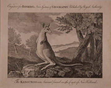 Bass Coast Shire Council - Robert Smith Collection
Artwork, other - The Kanguroo, Anonymous English
An animal found on the Coast of New Holland Engraving kangaroo