Showing 11902 items
matching geo-map
-
 Broadmeadows Historical Society & Museum
Map - Map of Australia, John Bartholomew & Son Ltd, Contour- coloured world map series: Australia, c. 1955
Printed 1955Quality Map in good condition, can be used for research purposesMap of Australia - Colour contoured - printed on cloth, scale 1:5,000,000australia, map, historical information, education -
 Lara RSL Sub Branch
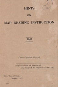
Booklet, Hints of Map Reading Instruction 1943, 00/08/43
Used to instruct the serviceman how to read and question learnt material about map reading. The map as a plan, as a reference point, a measurement of distance, a relief and direction in any situation Paper Booklet with 24 pages that have faded to a beige colour A5 in size ReservedFront page has the name of the booklet with added date 1943. Crown Copyright. Prepared under the direction of the Imperial General Staff The War Office August 1943 22307booklet, map instruction, 1943 -
 Orbost & District Historical Society
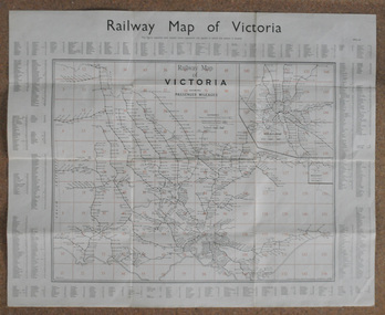
map, Railway Map of Victoria, 1.8.1965
The Bairnsdale-Orbost railway was opened in 1916 to serve the agricultural and timber industry. Because of the decline in traffic and heavy operating costs, the line was finally closed in August, 1987.This item is associated with the history of the Orbost-Bairnsdale railway line and therefore reflects the role that the rail line played in the social and economic history of Orbost.A large rectangular shaped paper map of all railway stations in Victoria. It is dated 1st August 1965. It is divided into grids. Stations are listed around the map. A key is provided and each station has a grid reference.map-railway victorian-railways -
4th/19th Prince of Wales's Light Horse Regiment Unit History Room
Maps, Major & Mrs Holt's Battle Map of Gallipoli, 2000
Brochure containing battle field maps of Gallipoli campaign. Designed as a guide for visitors97809585229662maps, gallipoli. holt -
4th/19th Prince of Wales's Light Horse Regiment Unit History Room
Booklet (4 copies), Hints on Map Reading Instruction 1943, Aug 1943
Soft covered booklet issued to help junior instructors in the teaching of map readingmap reading -
 Federation University Historical Collection
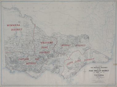
Plan, Map Showing the Pastoral Holdings of the Port Phillip District 1835-1851 Now Victoria, 1932, 1932
Another name for Pastoral Holdings is squatting runs. Information on Alfred Stephen Kenyon of the Historical Society of Victoria can be found at http://adb.anu.edu.au/biography/kenyon-alfred-stephen-6936/text12035 Map of Victoria showing the boundaries of the Port Phillip District (Victoria) pastoral boundaries. pastoral holdings, squatters, squatting, victoria, land, crown lands, a.s. kenyon, alfred stephen kenyon -
 Federation University Historical Collection
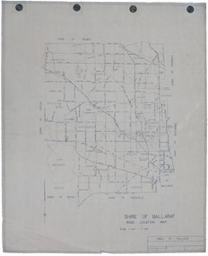
Map, Shire of Ballarat Road Location Map, 1968, 05/06/2014
White paper road location map. Scale 1 mile to 1 inchballarat, shire of ballarat, roads, dowling forest, lake burumbeet, lake learmonth, ascot, windermere, tourello -
Stawell Historical Society Inc
Map, Easton Johnstone, Map of Stawell Surveyed by Easton Johnstone 1872, 1872
Victoria Co Crushing Machine. St Georges Co Crushing machine. Wimmera Co Crushing Machine. Government Reservoir and Drainage. Sloan Street, Skene Street Mines. old Mine WorkingsA2 map of Stawell Reefs Area. Showing Crushing Machines & Title InfoSurveyed by Easton Johnstone Contract Surveyor. Photo-Lithographed at the Department of Lands & Survey. Melbourne By J Noone 9th May 1872mining -
Whitehorse Historical Society Inc.
Map, Map of Mont Albert, Box Hill, Surrey Hills and Blackburn, c 1933
Map of Box Hill and Surrounds, showing location of Box Hill Grammar School.Map of Box Hill and Surrounds, showing location of Box Hill Grammar School.Map of Box Hill and Surrounds, showing location of Box Hill Grammar School.maps, box hill grammar school -
Whitehorse Historical Society Inc.
Map, Broadbents map no 230, To and from Clifford Park, c1955
Map - To and From Clifford Park by Broadbents 1955 - 56 prepared for a scout jamboree.maps, eastern suburbs (melbourne), scout groups -
Whitehorse Historical Society Inc.
Map, Melbourne Metropolitan Planning Scheme. Map No 39, c1950
Map of central Melbourne showing planning zones with gardens and principal buildings marked.Map of central Melbourne showing planning zones with gardens and principal buildings marked.Map of central Melbourne showing planning zones with gardens and principal buildings marked.maps, city of melbourne, city of fitzroy, city of south melbourne, city of collingwood -
Whitehorse Historical Society Inc.
Map, Map of City of Nunawading, n.d
Hand drawn map of City of Nunawading showing heights above sea level.city of nunawading, maps -
 RMIT Design Archives
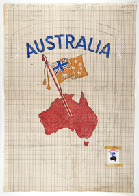
Mixed media - Drawings, Design for clothing label featuring map of Australia
Cash's first began manufacturing name tags, woven badges and woven labels in Australia in 1913, and since then countless Cash's labels have been sewn onto school and club jumpers. Point paper design featuring map and flag. Corresponding clothing label attachedtextile design, rmit design archives -
National Vietnam Veterans Museum (NVVM)
Photograph, Sketch of Battle Map, Ngok Tavak, Mary 1968
Captain John E D White, Australian Army Training Team in Vietnam (AATTV) took over command of 11 Mobile Strike Force (Mike Force) Company in Da Nang, Vietnam, in February 1968. He was 26 years old. The 2 NVA Division was moving from Laos into South Vietnam and his mission was to establish contact with the division and trace its movements south. In mid-March the company was air lifted to the Special Forces camp of Kham Duc, near the Laotian border. They used an old French Foreign Legion fort as a temporary base from which patrols could be sent out. White called it Ngok Tavak after a nearby mountain. Initially, patrols failed to find the enemy, but in late April a patrol clashed with the enemy. At the same time, White received intelligence that the NVA division was closing in. At night they could hear explosions in the distance heading toward them. White decided their best chance was to leave the fort and take to the jungle to adopt guerrilla tactics. However, in the meantime a platoon of United States Marine Corps artillery arrived bringing with them two howitzers and a stockpile of ammunition. To abandon the fort was to abandon the guns. White contacted Da Nang, explaining the predicament, and was ordered to remain where he was. A Civilian Irregular Defense Group (CIDG) platoon was sent to reinforce his numbers. This was a para military force comprised mainly of indigenous highlanders, trained by United States Special Forces. They also brought with them two mortars and their crews. At 3.15am on 10 May 1968 some members of the CIDG chose to assist the NVA to attack the fort instead of supporting Mike Force, and close hand to hand fighting followed, along with grenade attacks and heavy machine gun fire. Air support offered a brief respite from the NVA attack, and some NVA forces were pushed back outside the perimeter by counter attacks, but at 9am White contacted Da Nang to advise that his position was untenable. A second attack was imminent and they could not withstand it, so they would have to withdraw. The wounded were evacuated by helicopter (under orders from Major Mai, the NVA had not attacked the previous medical helicopters that collected the wounded under the cover of air strikes) and at 1pm the rest of the force evacuated east, into the jungle. The NVA did not notice their withdrawal, and continued mortar attacks on the fort for another ninety minutes. Seven kilometres from the fort White called for a helicopter withdrawal of his forces. The force was successfully lifted to Kham Duc and then Da Nang. (Credit AWM)Annotated hand-drawn map of the fort at Ngok Tavak, 10 May 1968.battle of ngok tavak, john white, battle map -
 Federation University Historical Collection
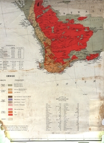
Map, Geological Map (Southern Western Australia), post 1880
Includes the routes of exploration, including E. Giles, A. W. Howitt, Burke & Wills, Hume & Hovell, Major Mitchell, A Forrest.A section of a map showing geology and routes of exploration. Southern Western Australia only geology, exploration, railways, electric telegraphs -
 The 5th/6th Battalion Royal Victoria Regiment Historical Collection
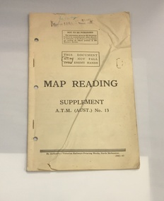
Booklet - Book, Map Reading No. 13 1942, 1942
Military guide to map readingBook made of yellowed paper with black print. It is bound by two staples and has three holes punched into the left side for storage in a ring binder. There is a crease that runs from the bottom left to the top right of the cover.wark vc club, military manuals, ww2, regimental property -
 Ringwood and District Historical Society
Photograph, Map of Melbourne & Vicinity - 1853. Survey of Port Phillip. Plan in Bonwick's "Settlement of Port Phillip"
Catalogue card reads, 'Map of Melbourne & Vicinity - 1853. Survey of Port Phillip. Plan in Bonwick's "Settlement of Port Phillip"'. -
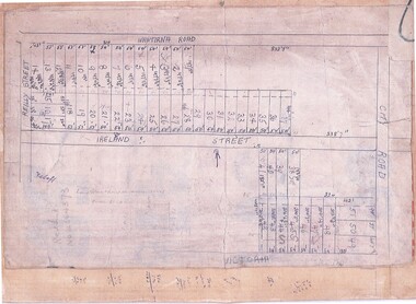 Ringwood and District Historical Society
Document, Subdivision Map (Undated) - Ringwood, Victoria
Hand-drawn copy of subdivision plan showing numbered residential allotments with property dimensions.Map includes Wantirna Road, Ireland Street, City Road and Victoria Street (later Regina Street), Ringwood, Victoria. -
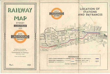 Ballarat Tramway Museum
Map, NSWGR, "Railway Map of Sydney Suburban and Underground" - 1939, 1939
Light card or Heavy paper. Colour map showing location of Sydney stations and entrances and where the trains ran. Issued as No.1. Title "Railway Map of Sydney Suburban and Underground" - 1939. Handle with care - both copies.trams, tramways, sydney, railway map, suburban and underground, trams -
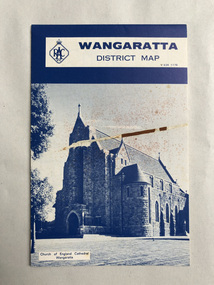 Robin Boyd Foundation
Map, RACV General Insurance, RACV Wangaratta District Map
District Map of Wangaratta and surrounding townshipswangaratta, victoria, map, beechworth, albury-wodonga, walsh st library -
Moorabbin Air Museum
Map (Item) - AAF Cloth Map- Southwest Pacific Area: Nos. 22,25 & 26
-
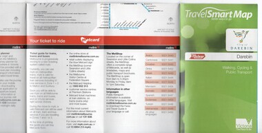 Melbourne Tram Museum
Map, Department of Transport, "TravelSmart Map - Darebin", Jun. 2010
Map - pocket - 28 fold - showing walking, cycling and public transport in the City of Darebin, using a Melway Map base along with public transport information, Metcard, cycling and walking groups. Produced by the Dept of Transport June 2010.trams, tramways, city of darebin, maps, public transport, metcard, metlink -
4th/19th Prince of Wales's Light Horse Regiment Unit History Room
Booklet, Capt W Stanley Lewis MSc, FRGS, Military Map Reading for the New Army, Feb 1941
Soft covered booklet covering various details of military maps and how to read them. Price Two shillings and six pencemanual, map reading -
Ringwood and District Historical Society
Map, Photocopy of Part of a map of Warrandyte -Yarra Valley area year unknown possibly c1930, c1930
Photocopy of Part of a map of Warrandyte -Yarra Valley area year unknown possibly c1930 -
Ringwood and District Historical Society
Map, Prepared by Commonwealth Section Imperial General Staff, Topographical map of Ringwood and surrounding areas dated 1-Aug-1935
Topographical map of Ringwood and surrounding areas dated 1-Aug-1935. Two copies.Ringwood Zone -
 National Vietnam Veterans Museum (NVVM)
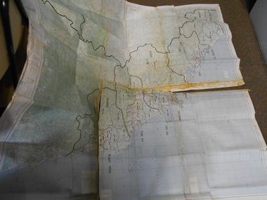
Map, Relief Map
Large scale map of Vietnam showing marked bounaries of provinces. Scale 1:250,000Series L500 Sheet NE 49-13 Edition 3-AMSmap, aattv -
Stawell Historical Society Inc
Map, CFA, Map of Stawell / deep Lead Fire of 31/12/2005, 2006
Fire Started from lightning strike near Deep Lead and Burned on New years Eve with nasty North Wind, Southerly to Black range, Then Easterly towards Great western. Fire Subduded by Rain Event on 2/1/2006.Laminated Coloured Map of Stawell / Deep Lead 4/1/2006 with Fire Perimeters.CFA GIS Services Community Services -
Whitehorse Historical Society Inc.
Map, Map of the City of Nunawading, c1960, c1960
Map of the City of Nunawading prepared by Drake & Co, Real Estate Agents in about 1960.city of nunawading, drake & co, maps -
Whitehorse Historical Society Inc.
Map, Map of East and South eastern suburbs of Melbourne, 1930s
Map of suburbs of Melbourne from Kew to Ringwood and South Morang Station to East Oakleigh.Map of suburbs of Melbourne from Kew to Ringwood and South Morang Station to East Oakleigh.Map of suburbs of Melbourne from Kew to Ringwood and South Morang Station to East Oakleigh.blackburn, mitcham, hawthorn, box hill, doncaster, templestowe -
Whitehorse Historical Society Inc.
Document, Map of Orchards, 1922
1922 Map of orchards in the City of Nunawading, coloured green. This is a magnified localised view of ND66orchardists, orchards, blackburn, mitcham, tunstall, vermont, east burwood, tally ho