Showing 359 items matching "geological society"
-
 Bendigo Historical Society Inc.
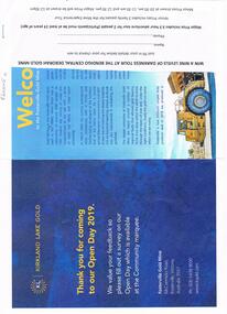
Document - FOSTERVILLE GOLD MINE COLLECTION: OPEN DAY 2019
Two page document for Kirkland Lake Gold Open day 2019. Open Day activities include: bus tours, technical services display, geology, exploration, processing, community and environment display, minerals council of Australia, Swick drilling, Central Deborah Gold Mine, Face painting, Goldfields Re-vegetation, Delecca's hire equipment, MacMahon underground mining services, Sandvik, and ISH24 safety specialists. Map of 'Fosterville Gold Mine Site Map' with activities highlighted. Fosterville is Victoria's larges gold producer and in 2918 a records 356,230 ounces at an average grade of 24.9 g per tonne. The mine has over 600 full time employees in 2019. Entry for '9 levels of darkness' tour at Central Deborah Mine attached.bendigo, mining, fosterville gold mine -
 Bendigo Historical Society Inc.
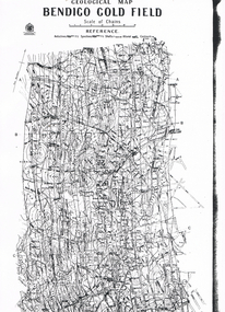
Map - LONG GULLY HISTORY GROUP COLLECTION: GEOLOGICAL MAP - BENDIGO GOLD FIELD
Copy of a Geological Map of the Bendigo Gold Field. Map shows Lines of Reef, Anticlines, Synclines, Shafts, Alluvial Contours Gullies and some street names. Copy is hard to read. There are two pages.bendigo, history, long gully history group, the long gully history group - geological map - bendigo gold field, mines department, h herman, lightning hill line, hustlers line, derby line, paddy's gully line, garden gully line, deborah line, sheepshead line, new chum line, nell gwynne line, british and foreign line, napoleon line, carshalton line, thistle line, christmas line, lancashire line -
 Bendigo Historical Society Inc.
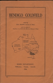
Book - BENDIGO GOLDFIELD
booklet, 51 pages. 'Bendigo Goldfield' issued by Geo Brown, Secretary for Mines. Mines Department 1936. Contains information on the geology of the Bendigo goldfield and major lines of reef and mines. Map of goldfield showing reef lines and mines attached to back cover.bendigo, mining, bendigo goldfield -
 Bendigo Historical Society Inc.
Map - GEOLOGICAL MAP OF BENDIGO GOLD FIELD
Two framed laminated maps (a,b) of Bendigo goldfield reef lines, map (b) is a continuation of the reef lines in map (a). On map(a) written in black on top: 'Geological Map, Bendigo Gold Field', Scale of chains, anticlines, synclines, shafts, alluvial and contours marked. Map (b) is continuation of (a). Written on the bottom RH corner of map: 'Prepared in 1923 in the Bendigo Office Mines Department under the direction of H. Herman, Director of Geological Surveys, from surveys by H.S. Whitelaw, Fiield Geologist, assisted by E.S. Usher & J. J. Moore. Re-issued in 1936.'H. Herman, Director of Geological Surveys, from surveys by H.S. Whitelaw, Fiield Geologist, assisted by E.S. Usher & J. J. Moore. Re-issued in 1936.'bendigo, mining, geological map. -
Bendigo Historical Society Inc.
Map - RAYWOOD GOLD FIELD MAP, 1902
Map. Raywood Gold Field Map. Linen backed map of Raywood and Neilborough Township and surrounds showing the location of varying underground workings. Surveyed by H S Whitelaw 1/6/02. It shows underground workings from The Perseverance Party and moreshed and Party and underground workings on the Old Pioneer Reef. Mentions the Parish of Yallook, Parish of Neilborough, Yarraberb, Mushroom Flat, Murray Valley Plain, Eaglehawk and Kerang Railway, Green Hill, Doughboy, Redmond's Gully, Pickpocket Lead, Raywood Lead, Inglewood Lead, Shaw's Road, Nuggety Shaft, Barkly Shaft, Maori Bendmap, gold field map, raywood gold field map, neilborough, h s whitelaw, geological survey of victoria bulletin no 12 plate 11 -
 Bendigo Historical Society Inc.
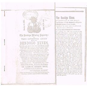
Document - THE BENDIGO MINING REGISTRY
Photocopy of The Bendigo Mining Registry or True Investors guide to all the Bendigo Mines in 1851 and up to 1883. Contains an original poem, Index, names and addresses of Legal Managers, names of Companies and Mining Managers, and reference page to a description of every mine in Bendigo, with length, size, depth, machinery, dividends, capital, number of shares, paid-up, and historical and scientific sketches - past and present - of the main situations. Twelve Lines of Reefs. The Gold Problem Scare Solved. Success of Deep Sinking. E - W & N. S. Parallelograms.document, gold, bendigo mines 1851 - 1883, the bendigo mining registry, r a murray, hay kirkwood, wm welch, district survey office, geological survey of victoria -
 Bendigo Historical Society Inc.
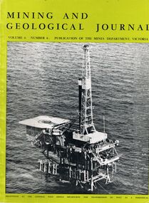
Document - MCCOLL, RANKIN AND STANISTREET COLLECTION: MINING AND GEOLOGICAL JOURNAL, 1970
McColl Rankin & Stanistreet, Mining and Geological Journal, Vol 6, No 6, contains articles on mining.organization, business, industrial, mccoll rankin & stanistreet, mining & geological journal -
Bendigo Historical Society Inc.
Map - GEOLOGICAL MAP BENDIGO GOLDFIELD, See above
Map: Geological map of the Bendigo Goldfield comprising 2 sheets , Numbered 9358a and 9358b. Prepared in 1923 re-issued in 1936map, bendigo, geological, geological map, bendigo goldfield -
 Bendigo Historical Society Inc.
Document - FOR NEWSLETTER - ACTIVITIES DURING OCTOBER
handwritten account of activities during October. Mentions taking bus groups to various locations and a visit to the Kangaroo Flat Technical School where the students had made a model of a mine and workings.document, for newsletter - activities during october, mr a llewellyn, south australian rural youth group, east meadows primary school, victoria hill, the central deborah mine, council of adult education geology group, mr wyn williams, bendigo institute of technology, kangaroo flat technical school, a richardson -
 Stawell Historical Society Inc
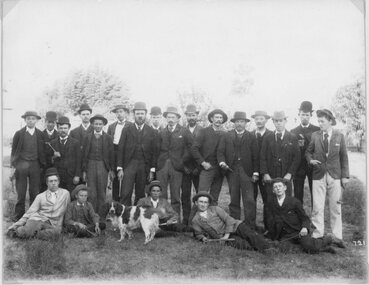
Photograph, School of Mines Stawell - Student Group on an excursion
School of Mines Stawell - Student Group. Note Geology picks probably on excursion.stawell education -
Stawell Historical Society Inc
Book - School Book, The Austral Geography for class VI
Dulcie Baily Born Stawell 1919 Married Murris Trickey 1941 School Book Grade 6Blue Fabric, Card, paperDulcie Bailey PRICE 1/- The AUSTRAL GEOGRAPHY FOR CLASS VI. By J.W. Gregory D,Sc., F.R.S. ?? Professor of of Geology in teh University of Melbourne Melbourne Christchurch, Wellington, Durbin, ?? & London Whitcombe & Thomas Limited All Rights Reserved. J.W. Gregory D.Sc F.R.S. education, primary school -
Stawell Historical Society Inc
Book - Science, The Natural History of Western Victoria, 1974
Reports from Symposium of Australian Insitutes of Agricultural Science, held in Horsham 1971. 8 chapters, 7 of science 8th extracts from Stapylton's Journal of Western Victoria, when travlling with Major Mitchell. Contains fold out Maps & photos. 1) Geology & Geomorphology 2) Soils 3) Vegitation 4) Birds 6) Aborigines 7) the first hundred years of agricultural development 8) The Journal of Granville William Chetwynd StapyltonSoft Yellow Cover and Black with Black taped spineBarry Clugston -
 Stawell Historical Society Inc
Book, Agnes Giberne, The World’s Foundation or Geology for Beginners, 1900
Harvard College Stawell Awarded to Margaret Telfordstawell education -
Stawell Historical Society Inc
Geological specimen - Mining, Broken Dimond Drill Pieces
Used to drill through the red Iron stone - reefs end of Stawell. Found along Darlington Road after drilling to erect a Power Pole 2X Cylindrical Broken used Dimond Drill - Core Samples, Basalt - granite -
Stawell Historical Society Inc
Map, Department of Mines Victoria, Alluvial Map Stawell Region, 1870's
c1870 Coloured map showing Black Range North to Stawell and Illawarra. Shows geological layout.Department Mines Victoria 1952/G/2 mining, gold, map -
Stawell Historical Society Inc
Map, Stawell Gold Mine, Provisional Plan Wonga Area, c1980
c1980 Preliminary Provisional Reconnaissance Plan Showing Workings Above and Below water LevelWonga Area 1:1000 Base Geological Sheet mining, gold, map -
Stawell Historical Society Inc
Map, Western Mining Stawell, Germania Summary Plan & Geology Western Mining Corporation, September 1988
Germania Summary Plan & Geopogy Western Mining Corporation Stawell VicGermania Summary Plan & Geology 2003-566 1:1000 mining, gold, map -
Stawell Historical Society Inc
Map, Geological Survey Office, Sloanes & Scotchmans united Mine, December 1916
Sloane & Scotchman's Geological Survey Map 1916 Showing Underground DrivesGeological Survey Office Ballarat December 1916 mining, gold, map -
Stawell Historical Society Inc
Map, Gold Mines of Australia, Geological Plan Wonga Mine Area Stawell Investigation, 1950
Plans Showing Stawell Investment 1950Gold Mines of Australia Ltd mining, gold, map -
Stawell Historical Society Inc
Map, Gold Mines of Australia, Stawell Investment Geological Plan. Mine Area showing Mineshafts
The Reefs Mine shaft locationsGold Mines of Australia Ltd mining, gold, map -
Whitehorse Historical Society Inc.
Map, Melbourne Geological Map, 1937
Geological Map of Melbourne & Suburbs.Geological Map of Melbourne & Suburbs. Scale: 40 chains to 1 inch with inset 10 miles to 1 inch. Includes Municipal and Parish boundaries, railways and stations, electric tramways, cable tramways, Post Offices and State schools. Area bounded by Braybrook, Preston, Blackburn & Brighton. Printed on linen.Geological Map of Melbourne & Suburbs. melbourne, maps -
 Rutherglen Historical Society
Map, 1908
This is a map produced as part of a book entitled.. It is also stamped on the back in blue ink with an oval ring and the words North of England Institute. Newcastle. Mining & Meterolgical Faculty. Purchased on 23rd July 2017 by the Society after research by member Simon Killeen. Mining map of one of the first mines in Rutherglen area ( Chiltern West)Cream paper, black printing, rectangle with a drawingGeographical Survey of Victoria, Memoir, No6. Plate XX Plan of Underground Workings CHILTERN VALLEY CONSOLS MINE, RUTHERGLEN, PARISH OF CHILTERN WESTgold, rutherglen, mining, chiltern, underground mine map, geological survey, reef drives -
Southern Sherbrooke Historical Society Inc.
Information Folder - geology of Dandenong Ranges
Information folder containing items pertaining to the geology of the Dandenong Ranges, including material prepared by Betty Hotchin for a talk to the Kallista Tourism course. Contents:-/typescript, re. basic features/photocopy, "The Dandenongs volcano and settlement in its great forest" by John Lundy-Clarke, published by Lilydale and District Historical Society/2 maps, Dandenong Ranges/List of reference materialdandenong ranges, geology of dandenong ranges -
 Otway Districts Historical Society
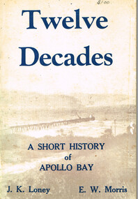
Book, Twelve Decades. J.K. Loney. E.W. Morris, c 1975
Twelve decades. A short history of Apollo Bay. J.K.Loney. E.W.Morris. 1st ed. J.K.Loney; Apollo Bay (Vic.); c 1975. 64 p.; illus. Soft cover.twelve decades; j.k.loney; e.w.morris; apollo bay; history; geology; shipping; names; war service; -
 Otway Districts Historical Society
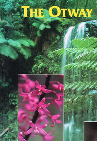
Book, Yaugher Print, The Otway Ranges, 1998
Flora and fauna found through the Otway Ranges interspersed with historical references from aboriginal occupation to the present day.The Otway Ranges.Trevor Pescott. 1st ed. Belmont (Vic); Yaugher Print; 1998. 112 p.; illus, map, bibliography. Soft cover. ISBN 0 9586562 1 5otway ranges; natural history; description; travel; geology; timber; -
 Otway Districts Historical Society
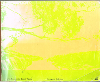
Book, Land Conservation Council, Report on the Corangamite Study Area, May 1976
The Report describes and assesses the natural resources of public land in the Corangamite study area, and provides a factual basis on which members of the community may base their submissions to the Council.Report on the Corangamite study area. Land Conservation Council. Melbourne; Land Conservation Council; May 1976. x, 310 p.; illus, maps (separate). Soft cover.land conservation council; corangamite; geology; physiography; climate; water resources; soils; vegetation; fauna; -
 Bendigo Historical Society Inc.
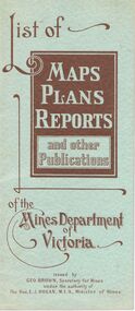
Document - LIST OF MAPS, PLANS, REPORTS PUBLISHED BY MINES DEPARTMENT VICTORIA 1938
Blue booklet, on front ' List of Maps, Plans, Reports and other publications of the Mines Department of Victoria. Issued by Geo Brown Secretary for Mines under the authority of The Hon. E.J. Hogan, MLA, Minister of Mines. Booklet contains list of publications of geological reports, maps etc for Ararat, Ballarat, Beechworth, Bendigo, Castlemaine, Gippsland, Maryborough.Geo Brown, Secretary for Mines under the authority of The Hon.E.J. Hogan, M.L.A. Minister of Mines.organisation, government, geological maps list -
 Bendigo Historical Society Inc.
Document - REEFS AND SPURS ON BENDIGO GOLDFIELD
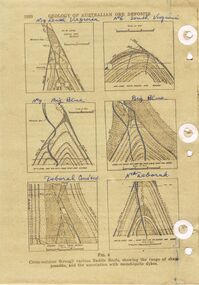
Three pages of information (copied ) regarding reefs and spurs on Bendigo Goldfield. Page 1020 'Geology of Australian ore deposits', drawings labelled in blue biro: No 19 level Virginia Mine, No 6 level South Virginia; No 9 level, Big blue, Big Blue, Deborah Cons'ted ( consolidated?) North Deborah. On bottom ' cross sections through various saddle reefs, showing the range of shape possible, and the association with monchiquite dykes' Page 1021 ( cont) Virginia South Extended; 3000ft New Chum Rly; Catherine Reef, Spurs in Carlisle. On bottom ' Cross sections through a trough reef, 'double' saddle reef and spurry systems. Final page: mines listed and descriptions of workings: Golden Age, Johnson's Reef Extended, Golden Pyke, Constellation, Great Northern, Virginia, Specimen Hill United, New Argus, Clarence United, North Argus, South New Moon.bendigo, mining, reefs and spurs -
 Bendigo Historical Society Inc.
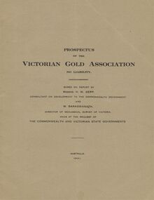
Document - MCCOLL, RANKIN AND STANISTREET COLLECTION: VICTORIAN GOLD ASSOCIATION, 1931
Prospectus of the Victorian Gold Association N.L. Based on a report by Messrs H. W. Gepp Consultant on Development to the Commonwealth Government and W. Baragwanath, Director of the Geological Survey of Victoria. Dated 1931 This company was formed to investigate the Deborah Mine, The Central Nell Gwynne Mine and the Monument Hill Mine. 12 pages including maps and Transverse Sections of the MinesThe Commonwealth and Victorian State Governments. E. Whitehead & Co., Pty., Ltd Printers 21 Equitale Place, Melbourne, C1.gold, mining, prospectus, bendigo, gold mines, victorian gold associatian, deborah mine, central nell gwynne mine, monument hill mine. -
 Bendigo Historical Society Inc.
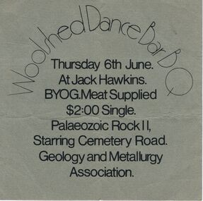
Document - PETER ELLIS COLLECTION: WOOLSHED DANCE BAR
Grey card for Woolshed Dance Bar B Q, Thursday 6th June. Palaeozoic Rock 11, Starring Cemetery Road. Geology and Metallurgy Association.entertainment, dance, bush dance, peter ellis collection, woolshed dance bar b q, jack hawkins, palaezoic rock 11, geology and metallurgy association