Showing 4549 items matching "historical maps"
-
 Eltham District Historical Society Inc
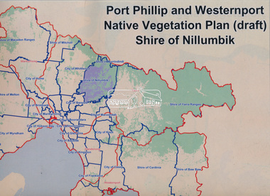
Book, Port Phillip and Westernport Native Vegetation Plan (draft), Shire of Nillumbik
Entire report available www.ppwema.vic.gov.au -
 Eltham District Historical Society Inc
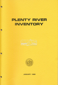
Book, Melbourne and Metropolitan Board of Works, Plenty River Inventory, 1986
The Melbourne and metropolitan Board of Works provided the lead agency role for implementing the Urban Waterways Program announced by the Victorian Government in February 1985. -
 Eltham District Historical Society Inc
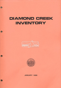
Book, Melbourne and Metropolitan Board of Works, Diamond Creek Inventory, January 1986
The Melbourne and metropolitan Board of Works provided the lead agency role for implementing the Urban Waterways Program announced by the Victorian Government in February 1985. -
 Eltham District Historical Society Inc
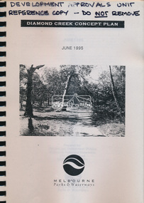
Book, Melbourne Parks & Waterways, Diamond Creek Concept Plan, June 1995
-
 Eltham District Historical Society Inc
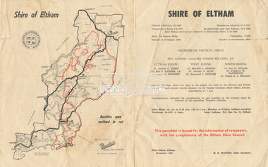
Document - Pamphlet, Shire of Eltham, December 1962
This pamphlet was issued for the information of ratepayers, with the compliments of the Eltham Shire Council. Subjects of information included: Shire statistics and history Members of Council 1962-63 Bushfires Dogs Rates Works Programme Shire Offices Town Planning Map of Shire of Eltham with Bushfire area outlined in redbushfires, charis pelling, charles m. a. pelling, councillors, dogs, eric dudley butler, eric percival harmer, franklin william nankervis, george l. cresp, leslie christopher docksey, m.b. watson, map, maxwell alexander spence, rates, raymond clive duncan, rodney d. quin, shire of eltham, shire offices, town planning, works programme -
 Eltham District Historical Society Inc
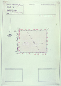
Slide - Photograph, Eltham Shire Council, Plan of Subdivision, Crown Allotment 8, Section 8A, Parish of Nillumbik,County of Evelyn, 1969
35mm colour positive transparency blue Agfacolour Service plastic mountC1, Pain, Sibbel and Carter, Research-Warrandyte Road, North Warrandyte, 4 August 1969carter, infrastructure, map, north warrandyte, pain, parish of nillumbik, plan of subdivision, planning, research-warrandyte road, sibbel, subdivison lots -
 Eltham District Historical Society Inc
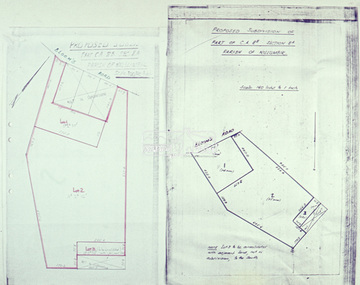
Slide - Photograph, Eltham Shire Council, Plan of Subdivision of Part of Crown Allotment 4, Section 2 at Kangaroo Ground, Parish of Nillumbik, County of Evelyn, 1969
35mm colour positive transparency blue Agfacolour Service plastic mountC6, Kimse, Kangaroo Ground-St Andrews Road, 4 August 1969infrastructure, kangaroo ground, kangaroo ground-st andrews rd, kimse, map, plan of subdivision, planning, subdivison lots -
 Eltham District Historical Society Inc
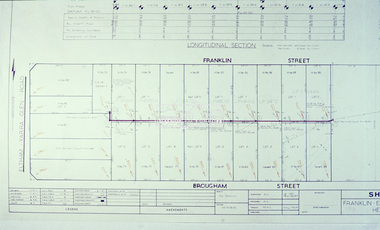
Slide - Photograph, Eltham Shire Council, EB 8 (b) Health Act Scheme, Franklin and Brougham streets, Eltham, 1969
35mm colour positive transparency blue Agfacolour Service plastic mountEB 8 (b) Health Act Scheme, 4 August 1969brougham steet, eltham, franklin street, infrastructure, map, planning, subdivison lots, health act scheme -
 Eltham District Historical Society Inc
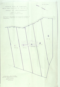
Slide - Photograph, Eltham Shire Council, Plan of Subdivision, Part of Crown Portion 3, Parish of Nillumbik, County of Bourke, 1969
35mm colour positive transparency blue Agfacolour Service plastic mountC5C, Delbridge, 4 lots, Rattray Road, 4 August 1969infrastructure, map, montmorency, planning, rattray road, subdivison lots, reichelt avenue -
 Eltham District Historical Society Inc
Slide - Photograph, Eltham Shire Council, Tentative plan of subdivision, part of Crown Allotment 22, Section B, Parish of Greensborough, County of Evelyn, 1969
35mm colour positive transparency blue Agfacolour Service plastic mountE11, N1069, Stogryn, Sub 'prop',infrastructure, map, planning, subdivison lots -
 Eltham District Historical Society Inc
Slide - Photograph, Eltham Shire Council, Proposed plan of subdivision, Mrs Du Lee, Warrandyte, 1969
35mm colour positive transparency blue Agfacolour Service plastic mountB2, Du Lee Subdivision, Research-Warrandyte Road, 4 August 1969infrastructure, map, planning, subdivison lots, du lee, glynns road, research-warrandyte road -
 Eltham District Historical Society Inc
Slide - Photograph, Eltham Shire Council, Proposed subdivision of Part of Crown Allotment 8B, Section 8A, Parish of Nillumbik, 1969
35mm colour positive transparency blue Agfacolour Service plastic mountE4, N0424, Stock subdivision, North Warrandyte, 4 August 1969infrastructure, map, planning, subdivison lots -
 Eltham District Historical Society Inc
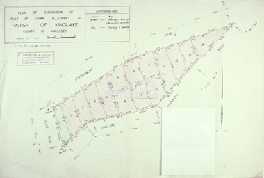
Slide - Photograph, Eltham Shire Council, Plan of subdivision of Part of Crown Allotment 41, Parish of Kinglake, County of Anglesey, 1969
35mm colour positive transparency blue Agfacolour Service plastic mountC8, N. Johnson, Kinglake-Glenburn Road, 4 August 1969infrastructure, map, planning, subdivison lots, n. johnson, kinglake-glenburn road, kinglake -
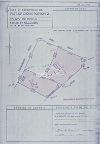
 Eltham District Historical Society Inc
Slide - Photograph, Eltham Shire Council, Plan of subdivision of Part of Crown Portion 2, Parish of Nillumbik, County of Evelyn, 1969
35mm colour positive transparency blue Agfacolour Service plastic mountC4, Warton, Panorama and Beleura, 4 August 1969infrastructure, map, planning, subdivison lots, beleura grove, old eltham road -
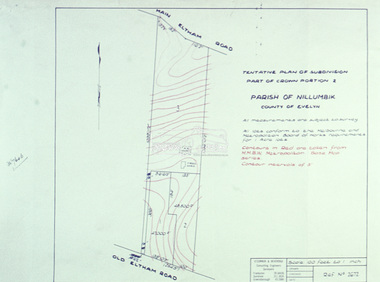 Eltham District Historical Society Inc
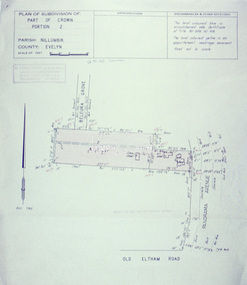
Slide - Photograph, Eltham Shire Council, Tentative Plan of Subdivision, Part of Crown Portion 2, Parish of Nillumbik, County of Evelyn, 1969
35mm colour positive transparency blue Agfacolour Service plastic mountB4, Fisher subdivision, Old Eltham Road and Main Road, 4 August 1969infrastructure, map, planning, subdivison lots, main road, old eltham road -
 Eltham District Historical Society Inc
Slide - Photograph, Eltham Shire Council, Tentative Plan of Subdivision, Part of Crown Allotment 20A and Part 20B, Parish of Nillumbik, County of Evelyn, 1969
35mm colour positive transparency blue Agfacolour Service plastic mountE2, N899, Young subdivision, Kangaroo Ground-Warrandyte Road, North Warrandyte, 4 August 1969infrastructure, map, planning, subdivison lots, kangaroo ground-warrandyte road, north warrandyte -
 Eltham District Historical Society Inc
Slide - Photograph, Eltham Shire Council, Proposed extension of Railway Road, Briar Hill, 1969
35mm colour positive transparency blue Agfacolour Service plastic mountA4, Railway Road intersection, 4 August 1969infrastructure, map, planning, subdivison lots, railway road, carter street bridge, para road, para road bridge, briar hill -
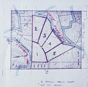 Eltham District Historical Society Inc
Slide - Photograph, Eltham Shire Council, Proposed subdivision of five approximately equal areas of 5 acres, Vol. 4061, Fol. 061, Overbank Road, North Warrandyte, 1969
35mm colour positive transparency blue Agfacolour Service plastic mountD4, 55341, Peck subdivision, Mount Pleasant Road, 4 August 1969infrastructure, map, planning, subdivison lots, overbank road, mount pleasant road, north warrandyte -
 Eltham District Historical Society Inc
Slide - Photograph, Eltham Shire Council, Plan of Subdivision, Part of Crown Allotments 5 & 6, Section 10, Parish of Nillumbik, County of Evelyn (Foster Road, Eltham East), 1969
35mm colour positive transparency blue Agfacolour Service plastic mountC5(a) DU (Vic) D/L Foster Road, Eltham East, 4 August 1969infrastructure, map, planning, subdivison lots, abersham court, ancona close, eltham east, floriston grove, foster road, frank street, gladwyn court -
 Eltham District Historical Society Inc
Slide - Photograph, Eltham Shire Council, Plan of Subdivision of Part of Crown Portion 2, Parish of Nillumbik, County of Evelyn, 1969
35mm colour positive transparency blue Agfacolour Service plastic mountC2, Grant of subdivision, Para and Glenauburn, 4 August 1969infrastructure, map, planning, subdivison lots, glenauburn road, para road -
 Eltham District Historical Society Inc
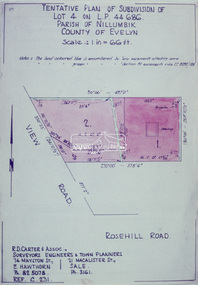
Slide - Photograph, Eltham Shire Council, Tentative Plan of Subdivision of Part of Lot 4 on L.P. 44 686, Parish of Nillumbik, County of Evelyn, 1969
35mm colour positive transparency blue Agfacolour Service plastic mountB3 Robinson prelim subdivision, View Road, 4 August 1969infrastructure, map, planning, subdivison lots, view road, rosehill road, lower plenty -
 Eltham District Historical Society Inc
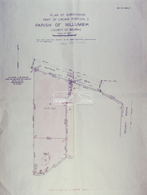
Slide - Photograph, Eltham Shire Council, Plan of Subdivision, Part of Crown Portion 3, Parish of Nillumbik, County of Bourke, 1969
35mm colour positive transparency blue Agfacolour Service plastic mountB3 Robinson prelim subdivision, View Road, 4 August 1969infrastructure, map, planning, subdivison lots, rattray road -
 Eltham District Historical Society Inc
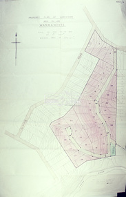
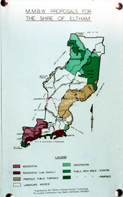
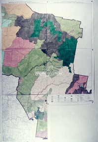
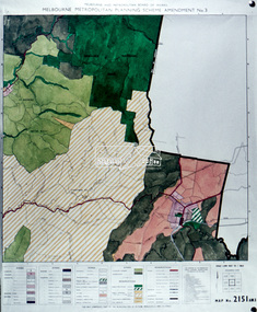
Slide - Photograph, Eltham Shire Council, Shire of Eltham, Melbourne Metropolitan Planning Scheme, Amendment No. 3, Melbourne and Metropolitan Board of Works, Apr 1972
35mm colour positive transparency blue Agfacolour Service plastic mountmap, melbourne metropolitan board of works, mmbw, planning proposals, shire of eltham, planning -
 Eltham District Historical Society Inc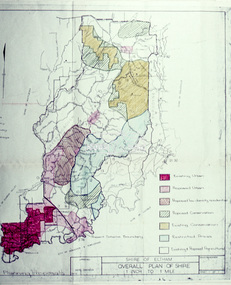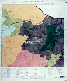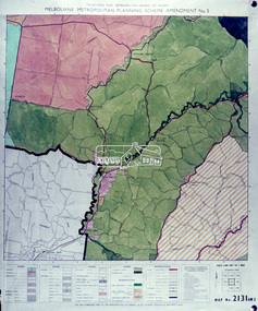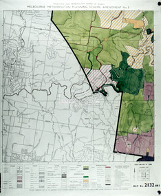
Slide - Photograph, Eltham Shire Council, Shire of Eltham, Melbourne Metropolitan Planning Scheme, Amendment No. 3, Melbourne and Metropolitan Board of Works, Apr 1972
35mm colour positive transparency blue Agfacolour Service plastic mountmap, melbourne metropolitan board of works, mmbw, planning proposals, shire of eltham, planning