Showing 716 items
matching land allotments
-
 Bendigo Historical Society Inc.
Document - H.A. & S.R. WILKINSON COLLECTION: CONTRACT OF SALE
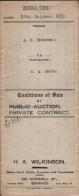
Conditions of sale by private contract dated 17th October, 1932 between A.G. McKenzie (seller) and G.A. Smith (buyer) for land situate No.39 Hill Street, Bendigo being residence area allotment 447 section K, together with weatherboard dwelling and all sundry.organization, business, h.a. & s.r wilkinson real estate -
 Bendigo Historical Society Inc.
Document - H.A. & S.R. WILKINSON COLLECTION: CONTRACT OF SALE
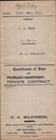
conditions of sale by private contract dated 15th May, 1933 between J.A. Nash (seller) and F.A. Stacpoole (buyer) for piece of land situate No.133 Sternberg Street,, and Skene Street, Bendigo being allotment 9 and 3 section 39C described in certificate of title volume 1361 folio 272162 and certificate of title volume 3263 folio 652414, together with 10-roomed brick and weatherboard dwelling and shop with street verandah, also gas stove, copper, troughs and bath. Also the complete stock and plant and goodwill of the vendor's butchering business carried on from above shop and premises. Price 1,150 pounds.organization, business, h.a. & s.r wilkinson real estate -
 Bendigo Historical Society Inc.
Document - H.A. & S.R. WILKINSON COLLECTION: CONTRACT OF SALE
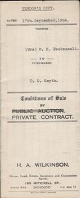
Conditions of sale by private contract dated 17th September, 1934 between Mrs. M.H. Beckensall (seller) and D.L. Smyth for land situate corner McIvor Road and Donovan, Bendigo being Crown allotment 1 section 93C described in Crown grant volume 265 folio 52937. Price 200 pounds. Vendor's copy.organization, business, h.a. & s.r wilkinson real estate -
 Bendigo Historical Society Inc.
Document - H.A. & S.R. WILKINSON COLLECTION: CONTRACT OF SALE
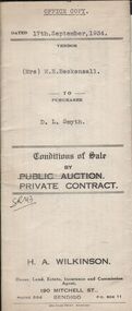
Conditions of sale by private contract dated 17th September, 1934 between Mrs. M.H. Beckensall (seller) and D.L. Smyth for land situate corner McIvor Road and Donovan, Bendigo being Crown allotment 1 section 93C described in Crown grant volume 265 folio 52937. Price 200 pounds. Office copy.organization, business, h.a. & s.r wilkinson real estate -
 Bendigo Historical Society Inc.
Document - H.A. & S.R. WILKINSON COLLECTION: CONTRACT OF SALE
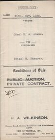
Conditions of sale by private contract dated 20th May, 1935 between Mrs. E.A. Adams (seller) and Miss M. Shearer (buyer) for land situate 43 Jackson Street, Long Gully being Crown allotment 181 section A and described in certificate of title volume 5564 folio 1112609, together with 4-roomed weatherboard dwelling and all sundry. Price 190 pounds. Also 2 receipts from City of Bendigo for rates.organization, business, h.a. & s.r wilkinson real estate -
 Bendigo Historical Society Inc.
Document - H.A. & S.R. WILKINSON COLLECTION: CONTRACT OF SALE
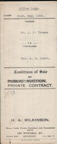
Conditions of sale by private contract dated 31st May, 1935 between Mr. E.T. Thomas (seller) and Mrs. A.M. Smyth for land, as fenced, situate corner Hargreaves and Wattle Streets, Bendigo, being Crown allotment 25 section 97C described in certificate of title volume 1662 folio 332318. Also land adjoining the above, together with 6-roomed weatherboard dwelling and all sundry. Price 435 pounds.organization, business, h.a. & s.r wilkinson real estate -
 Bendigo Historical Society Inc.
Document - H.A. & S.R. WILKINSON COLLECTION: CONTRACT OF SALE
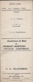
Conditions of sale by private contract dated 5th August, 1935 between E.T. Thomas (seller) and W.H. Stephenson (buyer) for land situate in Shipp Street, Bendigo being part of Crown allotment 308 section H, having a frontage of 66 feet to Shipp street by a depth of 155 feet 1 inch, being the south-western half of the said block. Price 135 pounds.organization, business, h.a. & s.r wilkinson real estate -
 Bendigo Historical Society Inc.
Document - H.A. & S.R. WILKINSON COLLECTION: CONTRACT OF SALE
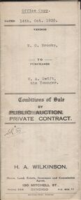
Conditions of sale by private contract dated 14th October, 1935 between W.G. Brooks (seller) and W.A. Swift the Younger (buyer) for land situate No. 293 King Street, Bendigo being Crown allotment 2 section 43A described in Crown grant volume 3020 folio 603887, together with weatherboard dwelling and all sundry. Also electric light fittings, bath, copper and troughs. Price 255 pounds.organization, business, h.a. & s.r wilkinson real estate -
 Bendigo Historical Society Inc.
Document - H.A & S.R. WILKINSON COLLECTION: CONTRACT OF SALE
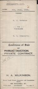
Conditions of sale by private contract dated 5th June, 1936 between W.J. McMahon (seller) and N.L. Svanosio (buyer) for land situate No. 64 Neale Street, Bendigo being parts of Crown allotments 200 and 201A section H, being the whole of the land remaining untransferred in certificate of title volume 4300 folio 859955, together with 5-roomed weatherboard dwelling and all sundry. Price 400 pounds.organization, business, h.a. & s.r wilkinson real estate -
 Bendigo Historical Society Inc.
Document - H.A. & S.R. WILKINSON COLLECTION: CONTRACT OF SALE
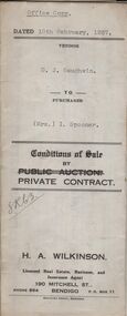
Conditions of sale by private contract dated 10th February, 1937 between D.J. Gaughwin (seller) and Mrs. I. Spooner (buyer) for land situate No. 27 Hamlet Street, Bendigo being Crown allotment 5 section 98C being land described in certificate of title volume 1681 folio 336040, together with 5-roomed weatherboard dwelling and all sundry. Also gas stove, all roller blinds, electric light fittings e globes, wire doors, wire screens and both heaters. Price 625 pounds.organization, business, h.a. & s.r wilkinson real estate -
 Bendigo Historical Society Inc.
Document - H.A. & S.R. WILKINSON COLLECTION: CONTRACT OF SALE
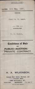
Conditions of sale by private contract dated 13th May, 1937 between Mrs. M.H. Amor (seller) and V.F. Sutch (buyer) for land situate Hayes Street, Bendigo being lot 2 on plan of subdivision, having a frontage of approx. 57 feet to Hayes Street, by a varying depth, being part of Crown allotment 510 section A. Price 60 pounds.organization, business, h.a. & s.r wilkinson real estate -
 Bendigo Historical Society Inc.
Document - H.A. & S.R. WILKINSON COLLECTION: CONTRACT OF SALE
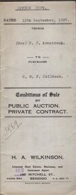
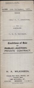
Conditions of sale by private contract dated 13th September, 1937 between Mrs. F.P. Armstrong (seller) and C.M.F. Skilbeck (buyer) for land situate 106 Thistle Street, Bendigo being part of Crown allotment 14 section 16B described in certificate of title volume 4386 folio 877150, together with 4-roomed weatherboard dwelling and all sundry. Price 300 pounds. Office copy.organization, business, h.a. & s.r wilkinson real estate -
 Bendigo Historical Society Inc.
Document - H.A. & S.R. WILKINSON COLLECTION: CONTRACT OF SALE
Conditions of sale by private contract dated 13th September, 1937 between Mrs. F.P. Armstrong (seller) and C.M.F. Skilbeck (buyer) for land situate 106 Thistle Street, Bendigo being part of Crown allotment 14 section 16B described in certificate of title volume 4386 folio 877150, together with 4-roomed weatherboard dwelling and all sundry. Price 300 pounds. Vendor's copy.organization, business, h.a. & s.r wilkinson real estate -
 Bendigo Historical Society Inc.
Document - H.A. & S.R. WILKINSON COLLECTION: CONTRACT OF SALE
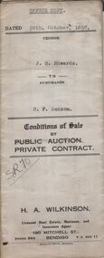
Conditions of sale by private contract dated 26th October, 1937 between J.B. Edwards (seller) and G.F. Sansom (buyer) for land situate ''Hazelbrae'' Corner Russell and Hamlet Streets, Bendigo and occupied by tenant, having a frontage of 82 feet 6 inches to Russell street by a depth of 68 feet 6 inches to Hamlet Street and being part of Crown allotment 22 section 74Cand described in certificate of title volume 3289 folio 657653, together with 5-roomed brick and weatherboard dwelling and all sundry.. Price 465 pounds.organization, business, h.a. & s.r wilkinson real estate -
 Bendigo Historical Society Inc.
Document - H.A. & S.R. WILKINSON COLLECTION: CONTRACT OF SALE
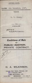
Conditions of sale by private contract dated 6th December, 1937 between R.D. Jones (seller) and Mrs. M.P. Simmons (buyer) for land situate in Thisle Street, Bendigo, being part of Crown allotment 17 section 17B described in conveyance no. 793, book 555, part of Crown allotment 18A described in certificate of title volume 6145 folio 1228836. Also the south eastern portion of allotment 18 section 17B described in residence area No. 7757. Price 120 pounds. Office copy.organization, business, h.a. & s.r wilkinson real estate -
 Bendigo Historical Society Inc.
Document - H.A. & S.R. WILKINSON COLLECTION: CONTRACT OF SALE
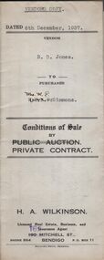
Conditions of sale by private contract dated 6th December, 1937 between R.D. Jones (seller) and Mrs. M.P. Simmons (buyer) for land situate in Thisle Street, Bendigo, being part of Crown allotment 17 section 17B described in conveyance no. 793, book 555, part of Crown allotment 18A described in certificate of title volume 6145 folio 1228836. Also the south eastern portion of allotment 18 section 17B described in residence area No. 7757. Price 120 pounds. Vendor's copy.organization, business, h.a. & s.r wilkinson real estate -
 Bendigo Historical Society Inc.
Document - H.A. & S.R. WILKINSON COLLECTION: CONTRACT OF SALE
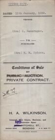
Conditions of sale by private contract dated 11th January, 1938 between Mrs. E. Banninger (seller) and Mrs. M.M. Spicer (buyer) for land situate in Wood Street, Long Gully, being Crown allotment 1 section P described in Crown grant volume 2129 folio 425693, together with 5-roomed weatherboard dwelling and all sundry, also bath, cement troughs and copper, wire doors, three venetian blinds, built in wardrobe, and vendor's interest in poultry pens built on land adjoining the above freehold, also all poultry and poultry farm equipment as per schedule on page 2. Price 550 pounds.organization, business, h.a. & s.r wilkinson real estate -
 Bendigo Historical Society Inc.
Document - H.A. & S.R. WILKINSON COOLLECTION COLLECTION: CONDITIONS OF SALE
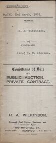
Conditions of sale by private contract dated 2nd March, 1939 between H.A. Wilkinson (seller) and Mrs. C.M. Stevens (buyer) for land situate No. 1 Carolin Street, Bendigo being part of Crown allotment 217 section H being land described in certificate of volume 6129 folio 1225728, together with 4-roomed weatherboard dwelling and all sundry. Also gas stove and all wire window screens. Price 650 pounds. Vendor's copy.organization, business, h.a. & s.r wilkinson real estate -
 Bendigo Historical Society Inc.
Document - H.A. & S.R. WILKINSON COLLECTION: CONTRACT OF SALE
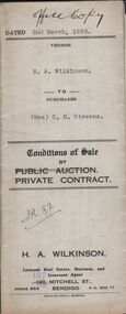
Conditions of sale by private contract dated 2nd March, 1939 between H.A. Wilkinson (seller) and Mrs. C.M. Stevens (buyer) for land situate No. 1 Carolin Street, Bendigo being part of Crown allotment 217 section H being land described in certificate of volume 6129 folio 1225728, together with 4-roomed weatherboard dwelling and all sundry. Also gas stove and all wire window screens. Price 650 pounds. Office copy.organization, business, h.a. & s.r wilkinson real estate -
 Bendigo Historical Society Inc.
Document - H.A. & S.R. WILKINSON COLLECTION: CONTRACT OF SALE
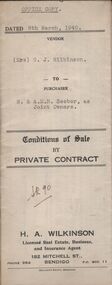
... , being Crown allotment 1 section 6A land described in certificate.... Wilkinson (seller) and R. and A.M.B. Seeber (buyers) for land ...Conditions of sale by private contract dated 8th March, 1940 between Mrs. G.J. Wilkinson (seller) and R. and A.M.B. Seeber (buyers) for land situate Panton Street, Golden Square, being Crown allotment 1 section 6A land described in certificate of title volume 3571 folio 750198, together with 5-roomed weatherboard dwelling and all sundry. Price 350 pounds.organization, business, h.a. & s.r wilkinson real estate -
 Bendigo Historical Society Inc.
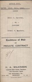
Document - H.A. & S.R. WILKINSON COLLECTION: CONTRACT OF SALE
... of Crown allotment 3 section77C land described in certificate.... Cattran (seller) and Miss V. Sanders (buyer) for land situate ...Conditions of sale by private contract dated 23rd July, 1940 between Mrs. I. Cattran (seller) and Miss V. Sanders (buyer) for land situate No.78 Olinda Street, Bendigo being part of Crown allotment 3 section77C land described in certificate of title volume 4701 folio 940052, together with 4-roomed weatherboard dwelling and all sundry. Price 272 pounds and 10 shillings.organization, business, h.a. & s.r wilkinson real estate -
 Bendigo Historical Society Inc.
Document - H.A. & S.R. WILKINSON COLLECTION: CONTRACT OF SALE
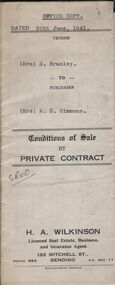
Conditions of sale by private contract dated 30th June, 1941 between Mrs. S. Bramley (seller) and Mrs. A.E. Simmons (buyer) for land situate Dillon Street, Long Gully, at present unoccupied being Crown allotment 497 section K described in certificate of title volume 3999 folio 799707. Also all the vendor's right title and interest in and to all that piece of land adjoining the above being land described in right to occupy residence area right No. 387, together with 5-roomed weatherboard dwelling and all sundry. Price 250 pounds.organization, business, h.a. & s.r wilkinson real estate -
 Bendigo Historical Society Inc.
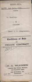
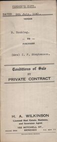
Document - H.A. & S.R. WILKINSON COLLECTION: CONTRACT OF SALE
... ) for land situate 25 Reginald Street, Bendigo being Crown allotment.... Hocking (seller) and Mrs. I.F. Stephenson (buyer) for land situate ...Conditions of sale by private contract dated 5th July, 1941 between B. Hocking (seller) and Mrs. I.F. Stephenson (buyer) for land situate 25 Reginald Street, Bendigo being Crown allotment 7 section 104C land described in certificate of title volume 2684 folio 536778, together with 5-roomed weatherboard dwelling and all sundry. Also all electric globes and shades, all wire doors and screens and ''Main'' gas stove connected in place of present gas stove. Price 400 pounds. This is the office copy, attached: copy of insurance policy and city of Bendigo rates notice and receipts of paymentsorganization, business, h.a. & s.r wilkinson real estate -
 Bendigo Historical Society Inc.
Document - H.A. & S.R. WILKINSON COLLECTION: CONTRACT OF SALE
... ) for land situate 25 Reginald Street, Bendigo being Crown allotment.... Hocking (seller) and Mrs. I.F. Stephenson (buyer) for land situate ...Conditions of sale by private contract dated 5th July, 1941 between B. Hocking (seller) and Mrs. I.F. Stephenson (buyer) for land situate 25 Reginald Street, Bendigo being Crown allotment 7 section 104C land described in certificate of title volume 2684 folio 536778, together with 5-roomed weatherboard dwelling and all sundry. Also all electric globes and shades, all wire doors and screens and ''Main'' gas stove connected in place of present gas stove. Price 400 pounds.organization, business, h.a. & s.r wilkinson real estate -
 Bendigo Historical Society Inc.
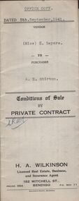
Document - H.A. & S.R. WILKINSON COLLECTION: CONDITIONS OF SALE
Conditions of sale by private contract dated 5th September, 1941 between Miss H. Sayers (seller) and A.E. Stirton (buyer) for land situate corner Violet and Pitt Streets, Bendigo, at present occupied by tenants, being Crown allotment 9A section 60 B land described in Crown grant volume 955 folio 190078, together with all buildings and erections on the said land. Subject to existing weekly tenancy. Price 200 pounds.organization, business, h.a. & s.r wilkinson real estate -
 Bendigo Historical Society Inc.
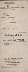
Document - H.A. & S.R. WILKINSON COLLECTION: CONTRACT OF SALE
... Square being Crown allotment 8a section 46B land described... allotment 8a section 46B land described in Crown grant volume 2325 ...Conditions of sale by private contract dated 23rd December, 1941 between L. Lazzari and Mrs. E. Lazzari (sellers) and Mrs. M.A. Smith (buyer) for land situate No. 18 Burn Street, Golden Square being Crown allotment 8a section 46B land described in Crown grant volume 2325 folio 464944, together with 5-roomed weatherboard dwelling and all sundry. Price 340 poundsorganization, business, h.a. & s.r wilkinson real estate -
 Bendigo Historical Society Inc.
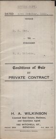
Document - H.A. & S.R. WILKINSON COLLECTION: CONTRACT OF SALE
Conditions of sale by private contract dated 19th October, 1942 between D.R. Hay (seller) and H.A. Stirton (buyer) for land situate corner Creek and Hamann Streets, Bendigo, having a frontage of 85 links to Hamann Street by a depth of 134 links to Creek Street and adjoining allotments 6 and 4, and described in right to occupy residence area title No. 5429, together with 4-roomed weatherboard dwelling and all sundry. Price 270 pounds.organization, business, h.a. & s.r wilkinson real estate -
 Bendigo Historical Society Inc.
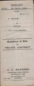
Document - H.A. & S.R. WILKINSON COLLECTION: CONTRACT OF SALE
Conditions of sale by private contract dated 1st March, 1944 between A. Wallace (seller) and R.J. & E. Shields (buyer) for land situate in Ellis Street, Kennington containing six acres being described in certificate of title volume 4983 folio 995671 section H and being Crown allotments 529,529A, 529B. Crown grant volume 6111 folio 1222194, crown allotments 530, 530A section H. Crown grant volume 6307 folio 1261328, Crown allotment 529F section H. Crown grant volume 6307 folio 1261329, Crown allotment 529C section H. Crown grant volume 6307 folio 1261293, crown allotment 529D section H. Crown grant volume 6307 folio 1261294 crown allotment 529E section H. Together with 6-roomed weatherboard dwelling and all sundry. Price 1,300 pounds.organization, business, h.a. & s.r wilkinson real estate -
 Bendigo Historical Society Inc.
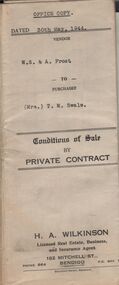
Document - H.A. & S.R. WILKINSON COLLECTION: CONTRACT OF SALE
Conditions of sale by private contract dated 30th May, 1944 between W.S. & A. Frost (sellers) and Mrs. T. M. Swale (buyer) for land situate No. 212 Queen Street, Bendigo being Crown allotment 2 section 139C described in certificate of title volume 4557 folio 911246, together with 5-roomed weatherboard dwelling and all sundry. Price 385 pounds. Also attached 6 receipt 2 issued by George Rasmussen, 2 by Langley & Son, 1 by J.S. Barker plus 1 Unknown for various materials.organization, business, h.a. & s.r wilkinson real estate -
 Bendigo Historical Society Inc.
Document - H.A. & S.R. WILKINSON COLLECTION: CONTRACT OF SALE
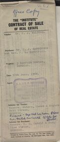
The Institute of Real Estate contract of sale dated 30th June, 1966 between Mr. C.J. Walters (seller) and Mr. C.J. Sandiford & Mrs. F.L. Sandiford (buyer) for land situate 3 Norfolk Street, Bendigo being part of Crown allotment 168, 311 and 312 section K described in certificate of title volume 6235 folio 960, together with all floor coverings, blinds, curtains and electric light fittings and shades. Price $7,000. Solicitors for vendor: Messrs. Watson, James & Rogers - Bull Street, Bendigo. Solicitor for purchaser: Messrs E.S. Cahill & Son - View Street, Bendigo.organization, business, h.a. & s.r wilkinson real estate