Showing 1290 items
matching lands
-
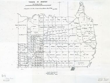 Whitehorse Historical Society Inc.
Map - Nunawading scaled Map, Nunawading, 1864
Parish plan of Nunawading, Lands Department, 1864, showing names of first purchasers of land. Copy also at NP215.parish of nunawading, land settlement, maps -
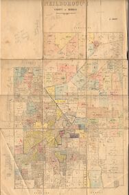 Bendigo Historical Society Inc.
Map - JACK FLYNN COLLECTION: NEILBOROUGH, 13/10/1927
Map: Parish of Neilborough, County of Bendigo. Parish plan.Photo Lithographed at the Department of Lands and Survey, Melbourne by W.J. Butsonmap, bendigo, parish plan, neilborough -
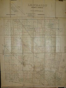 Bendigo Historical Society Inc.
Map - JACK FLYNN COLLECTION: LEICHARDT, 14/03/1`939
Map: Parish of Leichardt, County of Bendigo. Parish plan.Drawn and Reproduced at the Dept, of Lands and Survey, Melbourne, Victoria. 14.3.1939map, bendigo, parish plan, leichardt -
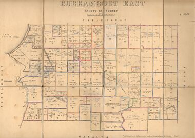 Bendigo Historical Society Inc.
Map - JACK FLYNN COLLECTION: BURRUMBOOT EAST, 21/12/1027
Map: Burrumboot East, County of Rodney. Parish plan.Photo Lithographed at the Department of Lands and Survey, Melbourne by W.J.Butson. 21.12.27map, rodney, parish plan, burrumboot east -
 Bendigo Historical Society Inc.
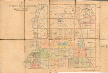
Map - JACK FLYNN COLLECTION: BRIDGEWATER, 6/10/1927
Map: Bridgewater , County of Bendigo. Parish plan.Photo Lithographed at the Department of Lands and Survey, Melbourne by W.J. Butson.map, bendigo, parish plan, bridgewater -
 Forests Commission Retired Personnel Association (FCRPA)
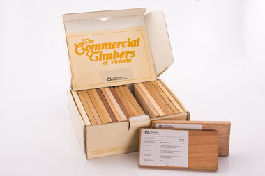
Commercial timbers of Victoria, Sample Box
Some decades ago a card sorting set for the identification and description of Australian timbers was developed for timber species which were available commercially and were in common usage, by the Commonwealth of Australia (CSIRO, Division of Forest Products) To complement and inform this national timber set each State or Territory developed reference timber sets of representative species. The Commercial Timbers of Victoria set was Victoria’s most recent (circa 1984) expression of this Victorian timber samples were sourced from logs selected by Forest Commission of Victoria (FCV) District Foresters and milled locally. Kiln drying and machining was carried out at timber producers Row, Web and Anderson, in Port Melbourne. Labeling and boxing was done by FCV Timber Inspectors, with box and booklet design and graphics handled in-house More recent timber samples were badged as Conservation Forests & Lands, reflecting historical government restructuring in the early 1980s Info: Simon MurphyProvided the public, industry (timber and associated), and educational facilities with a reference collection of notable Victorian timbers. Initially in a reduced format from 1940-50s, with boxed sets produced from 1981 until 1984A boxed set of timber samples representing the 20 tree species that were considered to be the most notable in Victoria. The set also includes an information booklet. Each timber specimen has information on species, occurrence, uses and physical properties Produced for sale by the the FCV and later by the Department of Conservation Forests and Lands. (CFL). forests commission victoria (fcv) -
 Bendigo Historical Society Inc.
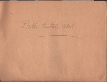
Document - MCCOLL, RANKIN AND STANISTREET COLLECTION: NORTH HUSTLERS GM CO, 19345/1940
Documents: folder contains - 1940 Lease applications for 11053 Bendigo, 1940 batch of 'Consent to the Inclusion of Certain Lands in a Mining lease', documents re: Mrs Highmore unlawfully occupying Crown Lands, application for Mining Lease, list - application for shares. North Hustlers Gold Mine Company.MCCOLL RANKIN AND STANSISTREETorganization, business, gold mining - legal, mccoll rankin and stansistreet, north hustlers gold mine company -
 Bendigo Historical Society Inc.
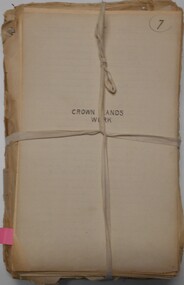
Document - CROWN LAND TRACINGS, BENDIGO, 1890 - 1910
Document: Crown land tracings, dark buff coloured foolscap paper tied with white tape. On front ' Crown Lands tracings 1890 - 1910'. Contains applications for crown lands, City of Bendigo, 1890 - 1910 including list of allotments, names of persons, locality and tracings of land referred to.crown land tracings, bendigo, sandhurst, land sales, crown land -
 Port Melbourne Historical & Preservation Society
Letter - Lands & Survey Office re permission to use land for football ground, 13 May 1880
Letter from Lands & Survey Office granting permission for use of land as per tracing sheet for football ground, 1880sport - australian rules football, sport - recreational grounds, peter gallienne grut, port melbourne football club, pmfc -
 Bendigo Historical Society Inc.
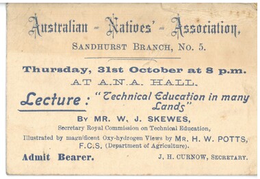
Document - HAMILTON COLLECTION: TICKET TO LECTURE, Early 1900s
Document. Ticket to Admit Bearer to a Lecture at the ANA Hall 31st October. ''Technical Education in Many Lands'', by Mr W.J.Skewes.performing arts, elocution, ticket to lecture -
 Bendigo Historical Society Inc.
Document - MCCOLL, RANKIN AND STANISTREET COLLECTION: APPLICATION FOR MINING LEASE/INCLUSION OF LANDS IN MINING LEASE, 1930's
Documents: 14 copies of application for a mining lease, 3 copies of consent to the inclusion of certain lands in a mining lease ( 1928 ).Secretary by the Mines. State Public Offices, Treasury Gardens, Melbourneorganization, mining, lease documents ( blank ), mccoll, rankin and stanistreet: lease application -
Whitehorse Historical Society Inc.
Document, Annual Report, 1968
Annual Report of the Place Names Committee of Victoria for the year ended 30 June 1968. Department of Crown Lands and Survey.Annual Report of the Place Names Committee of Victoria for the year ended 30 June 1968. Department of Crown Lands and Survey.Annual Report of the Place Names Committee of Victoria for the year ended 30 June 1968. Department of Crown Lands and Survey.crown lands, victorian government, victoria. place names committee -
 Falls Creek Historical Society
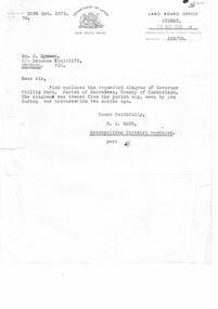
Letter - Letter Re Diagram Of Governor Phillip Park, Parish Of Narrabeen
Bob Hymans Collection Bob (Herman) Hymans (a former member of the Royal Netherlands Navy) was born in Bloemendaal, Holland on 30th September 1922. During World War II he fought against the Japanese in the Dutch East Indies (now Indonesia) and was imprisoned in Changi and on the Burma Railway. After gaining qualifications as a Ski Instructor, Bob arrived in Falls Creek in July 1950. Working as an Instructor and Supervisor at Bogong Lodge, Bob decided his future was in accommodation. He was successful in negotiating an indenture for land from the State Electricity Commission (SEC). It took Bob two years to build his Grand Coeur Chalet but, tragically, it was burned down in August 1961. Bob also built the first Chairlift in Australia. This was a single chairlift and the structure was built from wooden electricity poles. He was constantly full of new ideas and proposals for the village. Bob Hymans died on 7th July 2007. This Collection of documents and letters tells the story of Bob's endeavours to develop Falls Creek into the ski village it is today.This letter is significant because it reflects the desire for Bob Hymans to consider projects outside of Falls Creek.A letter from Department of Lands, New South Wales accompanying a diagram of Governor Phillip Park. Plans are no longer available.falls creek administration, governor phillip park -
 Marysville & District Historical Society
Map (Item) - Tourist Map, Tourists Resorts' Committee, Tourist's Map of Healesville Marysville and Warburton Districts, 13.10.1925
A tourist map for Healesville, Marysville and Warburton that was produced by the Tourists Resorts' Committee. This map was produced in 1925.A tourist map for Healesville, Marysville and Warburton that was produced by the Tourists Resorts' Committee.Photo Lithographed at the Department of Lands and Survey, Melbourne by W.J. Butson./ 13.10.25healesville, marysville, warburton, victoria, tourists resorts' committee, ben cairn, mount donna buang, the black's spur, the acheron valley, narbethong, launching place, tourist information, tourism, map, tourist map -
 Bendigo Historical Society Inc.
Map - JACK FLYNN COLLECTION: VILLAGE OF BETLEY, 30/06/1874
Map: Village of Betley, on the Bet Bet Creek, Parish of Dunolly. Parish plan.Photo Lithographed at the Department of Lands and Survey Melbourne by J. Noone 30.6.74map, gladstone, village, betley, bet bet creek, dunolly -
 Bendigo Historical Society Inc.
Map - JACK FLYNN COLLECTION: BAMAWM, 19/08/1924
Map: Parish of Bamawm, County of Bendigo. Parish plan.Photo Lithographed at the Department of Lands and Survey, Melbourne by W.J. Butson. 19.8.24map, bendigo, parish plan, bamawm -
 Bendigo Historical Society Inc.
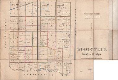
Map - JACK FLYNN COLLECTION: WOODSTOCK, 27/03/75
Map: Parish of Woodstock , County of Bendigo. Parish plan.Photo-Lithographed at the Department of Lands and Survey Melbourne by J. Noone. 27.3.79map, bendigo, parish plan, woodstock -
Stawell Historical Society Inc
Archive - Finance, Land Titles, Incorporation Papers
North Western Woollen Mills Pty. Ltd.PaperCrown Lands Titles Geoge V, George VI, Elizabeth IIfinance -
Stawell Historical Society Inc
Map, Lexington County of Borong 1910, 1910
Parish to the North East of MoystonA2 Parish mapPhoto Lithographed at the Department of Lands and Survey. Melbourne by T.F. McGauran 5.12.10survey -
Stawell Historical Society Inc
Map, T.F. McGauran, William Couty of Borong 1891, 1891
Stawell Water Supply Reserve. Grampians State Forest. Dairy Creek, Fyans Creek, Barney's Creek, Bovine Creek, Glasstree Creek, Stoney Creek. Stawell Water Supply Aquaduct Fkuming Tunnel.A2 Parish Map of Willam Inculdin Stawell Water Supply Reserve and Creeks. Marked in redPhoto Lithographed at the Department of Lands and Survey Melbourne. By T.F. McGauran 20.07.91 water supply survey -
Stawell Historical Society Inc
Map, T.F. McGauran, Winjallock County of Kara Kara, 1900
Noth of Navarre and BarkleyA2 Map0f Parish of Kara Kara.Photo Lithographed and the department of Lands & Survey, Melbourne by T.F. McCauran 22.10.00survey -
 Bacchus Marsh & District Historical Society
Map, Parwan Parish Map, County of Grant, 1909
A single page paper map showing the map for the Parish of Parwan in the County of Grant. A cadastral map showing parish boundaries and land ownership. The map is pasted into a bound volume containing 76 maps or plans in total. High resolution digital image stored on BMDHS computer network. Photo-lithographed at the Department of Lands and Survey, Melbourne by T.F. McGauran, 7.7.09. bacchus marsh region parish plans, parwan parish maps, parwan parish plan -
 Bacchus Marsh & District Historical Society
Map, Trentham Parish Map 1905 Copy 1
A single page paper map showing the map for the Parish of Trentham in the Counties of Dalhousie and Bourke. A cadastral map showing parish boundaries and land ownership. The map is pasted into a bound volume containing 76 maps or plans in total. High resolution digital image stored on BMDHS computer network. Photo-lithographed at the Department of Lands and Survey, Melbourne by T.F. McGauran 22.3.05 trentham parish maps, trentham parish plan, bacchus marsh region parish plans -
 Bacchus Marsh & District Historical Society
Map, Blackwood Parish Map, County of Bourke, 1892
A single page paper map showing the map for the Parish of Blackwood in the County of Bourke. A cadastral map showing parish boundaries and land ownership. The map is pasted into a bound volume containing 76 maps or plans in total. High resolution digital image stored on BMDHS computer network. Photo-lithographed at the Department of Lands and Survey, Melbourne by T.F. McGauran 14.7.92bacchus marsh region parish plans, blackwood parish plan, blackwood parish maps -
 Bacchus Marsh & District Historical Society
Map, Blackwood Parish Map, County of Bourke, 1905
A single page paper map showing the map for the Parish of Blackwood in the County of Bourke. A cadastral map showing parish boundaries and land ownership. The map is pasted into a bound volume containing 76 maps or plans in total. High resolution digital image stored on BMDHS computer network. Photo-lithographed at the Department of Lands and Survey, Melbourne by T.F. McGauran 21.7.05bacchus marsh region parish plans, blackwood parish plan, blackwood parish maps -
 Bacchus Marsh & District Historical Society
Map, Myrniong Parish Map, County of Bourke, 1882
A single page paper map showing the map for the Parish of Myrniong in the County of Bourke. A cadastral map showing parish boundaries and land ownership. The map is pasted into a bound volume containing 76 maps or plans in total. High resolution digital image stored on BMDHS computer network. Photo-lithographed at the Department of Lands and Survey, Melbourne by J. Noone, 17.7.82myrniong parish plan, myrniong parish maps, bacchus marsh region parish plans -
 Bacchus Marsh & District Historical Society
Map, Parish of Yangardook, County of Bourke 1876
The parish of Yangardook lies directly north of the township of Melton. The locality of Toolern Vale lies in the centre of this parish. A single page paper map showing the plan for the Parish of Yangardook in the in the County of Bourke. Scale 40 chains to 1 inch. The map is pasted into a bound volume containing 76 maps or plans in total. High resolution digital image stored on BMDHS computer network. Photo lithographed at the Department of Lands and Survey, Melbourne by J. Noone, 1.8.76yangardook parish maps, toolern vale victoria maps -
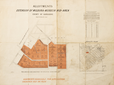 Merbein District Historical Society
Map - Allotments Extension of Mildura-Merbein Mid-Area, Allotments available, 23 November 1920
Allotments available to Discharged Soldiers Discharged Soldier's Settlement Act Historic Large map, folded in 4, coloured map of Merbein indicating allotments available and locality plan. Scale 10 chain to 1 inchPhoto-Lithographed at Department of lands Survey, Melbourne J. Butson 23.11.20discharged soldiers, ww1, soldier settlement, irrigation -
Port Melbourne Historical & Preservation Society
Letter - Department of Lands and Survey granting land for temporary reserve, 18 Mar 1860
Handwritten letter from Dept of Lands and Survey granting Crown land for temporary reserve as site for abattoirs 18 March 1861local government - borough of sandridge, industry - noxious, department of lands and surveys, clement hodgkinson