Showing 5329 items
matching levelling
-
 Bendigo Historical Society Inc.
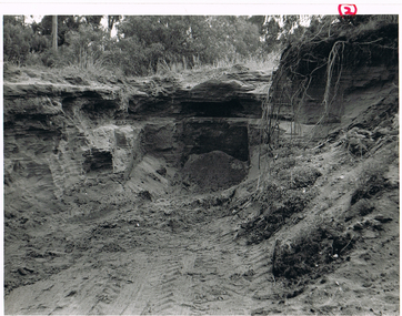
Photograph - MCCOLL, RANKIN AND STANISTREET COLLECTION: VIEW OF EXCAVATION
Black and white photo of a view of excavation into sandy heap below ground level. Possibly battery sands of Monument Hill Gold Mine, Bendigo.photograph, landscape, mullock and sandy heap. -
 Stawell Historical Society Inc
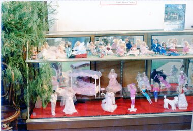
Photograph, Display of Dolls
Colour Photograph of a display of dolls in a two tier glass cabinet, the lower level the dools appear to be various Barbis Dolls. There is a chair to the left of the cabinetdolls -
 Whitehorse Historical Society Inc.
Article, More Trees face the Chop, 2016
Whitehorse councillors have granted seven more permits for the Level Crossing Removal Authority to chop down trees in Blackburn backyards despite protests.Whitehorse councillors have granted seven more permits for the Level Crossing Removal Authority to chop down trees in Blackburn backyards despite protests.Whitehorse councillors have granted seven more permits for the Level Crossing Removal Authority to chop down trees in Blackburn backyards despite protests.level crossing removal authority, trees, blackburn -
 Ballarat Heritage Services
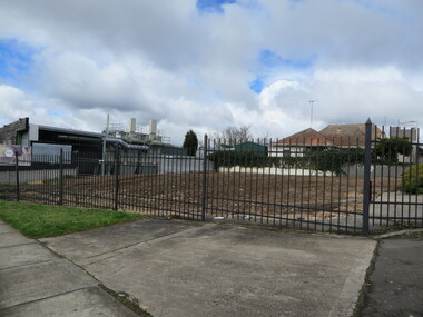
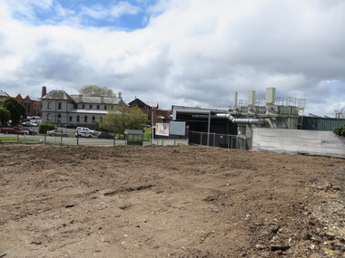
Photograph - Colour, Vacant Lot on the Corner of Armstrong Street South and Grant Street, Ballarat, 2017, 15/09/2017
Colour photograph of a vacant block. It had formerly been Leading Edge Computer which burnt down in 2016. The building was leveled in September 2017.armstrong street south, vacant black, grant street -
 Ballarat Heritage Services
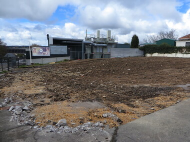
Photograph - Colour, Vacant Lot on the Corner of Armstrong Street South and Grant Street, Ballarat, 2017, 15/09/2017
Colour photograph of a vacant block. It had formerly been Leading Edge Computer which burnt down in 2016. The building was leveled in September 2017.armstrong street south, ballarat -
 Ballarat Heritage Services
Photograph - Colour, Vacant Lot on the Corner of Armstrong Street South and Grant Street, Ballarat, 2017, 15/09/2017
Colour photograph of a vacant block. It had formerly been Leading Edge Computer which burnt down in 2016. The building was leveled in September 2017.lamp, anderson and ritchie -
 Ballarat Heritage Services
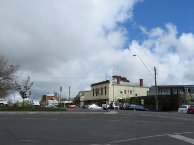
Photograph - Colour, Skipton Street, Ballarat Looking Towards the Mellow Hotel, 2017, 15/09/2017
Colour photograph of a vacant block. It had formerly been Leading Edge Computer which burnt down in 2016. The building was leveled in September 2017.lamp, anderson and ritchie -
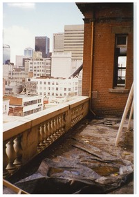
 Queen Victoria Women's Centre
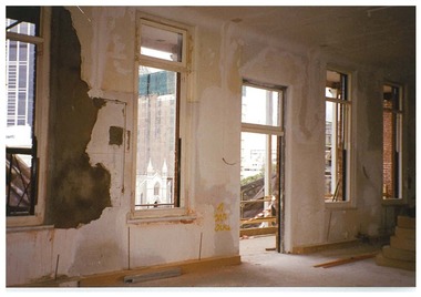
Photograph, c.1995/1996
Colour photograph. Level four in the Victoria room facing north west looking towards the veranda, no glass in windows. Taken during the restoration inspection.building construction, historic buildings -
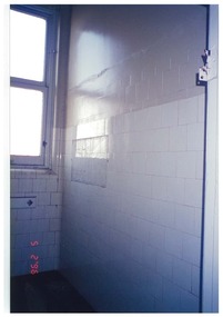
 Queen Victoria Women's Centre
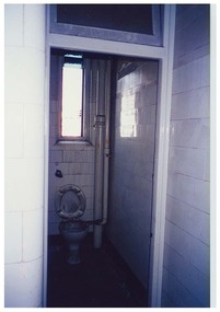
Photograph, c.1996
Colour photograph. Taken from south eastern corridor Level one a toilet cubicle in the building during restoration in what is in 2015 the archive room. historic buildings, building construction, photographs -
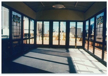
 Queen Victoria Women's Centre
Photograph, c. February 1996
Colour photograph. Taken on level 3 eastern balcony of the QVWC building facing south towards where in 2015 CASA house has their offices. historic buildings, cultural structures and establishments -
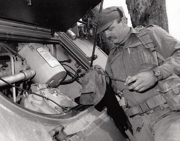 8th/13th Victorian Mounted Rifles Regimental Collection
Photograph - Collihole LRV
On 1 April 1991, ‘A’ Squadron 8/13 Victorian Mounted Rifles linked with 4/19 Prince of Wales’s Light Horse Regiment to form a new regiment of two squadrons: VMR Squadron and PWLH Squadron. The 4/19 Prince of Wales’s Light Horse title was retained, but the VMR Squadron continued to wear the VMR hat badge.Black and white photograph of Corporal K. Collihole, VMR squadron 4/19 Prince of Wales Light Horse checking noil level in vehicle.military -, vmr, vehicle, uniform, collihole -
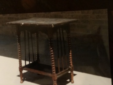 Mont De Lancey
Table
Owned by Moira BurgiTall corner table with bottom shelf and decorative carved legs. Has three wooden bars between top and bottom levels at each side.tables -
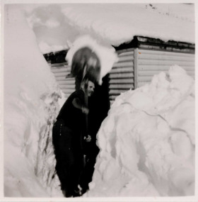 Falls Creek Historical Society
Photograph - Bogong, 1953
This photo is part of the Fred Griffith Photographic Collection documenting his time with the Australian Alpine Club and the formation of the Albury Ski Club. Frederick Charles “Fred” Griffith was born in Albury, NSW on 2 March 1910. Educated in Albury and Geelong Grammar. Beginning in 1927 he spent many years working first as a jackeroo and on a range of prominent pastoral and merino stud properties in NSW and Queensland. In 1935 he repurchased his former family property “Toonallook", Bowna, NSW and developed it to be the largest Romney Marsh stud in the world, exporting rams to Argentina. He introduced many innovative practices on his property including rabbit control measures and aerial crop dusting. He was an active member of the Albury Show Society and in 1949 established the Albury Sheep Show. Fred was also the Albury representative on the Graziers’ Association Council for over 30 years. He became a life member of both the Albury and Commercial Clubs. Fred’s greatest hobby was snow skiing. His first visit to the snow was to Kosciusko in 1919. The Albury Ski Club was formed in 1935 and Fred was an inaugural member. In 1949 they were granted a site at Falls Creek to build their own lodge. Fred guaranteed the Club for finance from the Bank of NSW. The first portion of the prefabricated building was constructed in Albury. It was transported to Falls Creek on the back of Fred’s truck and erected in one day. This was the bathroom section and the rest was completed in 1950. The original lodge was burned down in 1952 and a new one built the following year. In 1955, Fred also built the Bowna Lodge for his family in partnership with David Fairbairn. He became head of the North Eastern District Skiing Association (N.E.D.S.A.) and successfully applied to run the Australian Ski Championships. Fred also inaugurated children’s races at Falls Creek and ran them for about 20 years. He also formed the company “Falls Creek Ski Tows”. In 1956 Fred along with a group of key people selected the site for Thredbo Village. Fred and his brother sold Toonallook in sections between 1951 and 1974. He moved to Albury and set up as a landscape gardener and fencing contractor. After a serious work accident, Fred retired in 1985 and moved to Rosebud, Victoria where he died on 19 August 1992.Black and white square photograph of man shovelling snow with high levels of snow either side of him and a hut behind. There is snow on the roof of the hut. Stamped - SUPER / G & D . SERVICE Pencil - 61bogong, falls creek, snow, snowfields -
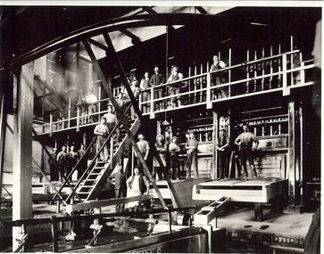 Bendigo Historical Society Inc.
Photograph - GOLD MINE BATTERY
Black and white photograph : 233 workers at goldmine battery. Stampers in background, 10 workers on the boxes, amalgamation in foreground. Eleven workers on upper level.mine, gold, miners underground., mines and mining, goldmine, miners, goldmine, battery, stampers, mining -
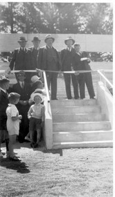 Linton and District Historical Society Inc
Photograph, Linton Recreation Reserve : Grandstand opening 1939
Sepia photograph of a group of men in suits and hats standing behind a barrier at the top of a short flight of steps, with children and others standing on ground level."This snap was taken about 1939 or so Linton Recreation Reserve Grandstand".linton recreation reserve, grandstand opening -
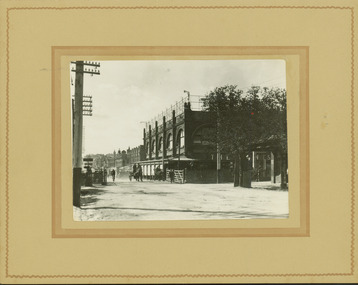 Kew Historical Society Inc
Photograph - Railway level crossing in Glenferrie Road, Glenferrie, E.J. Dower, c.1912
One of a series of photographs, taken by Edgar James Dower in the second decade of the twentieth century. Born and raised in Olinda, his family later moved to Surrey Hills. He worked as an adult as a clerk in the city office of the Metropolitan Gas Company, and in his role as a 'collector', he was able to photograph scenes including the construction of tramlines and associated buildings in Kew, Hawthorn, Camberwell and Surrey Hills. Later he established a real estate agency with his brother - the E.J. Dower Real Estate Agency, Dandenong Office.The image is an historically significant record of the development of transport infrastructure which was used to connect Victorians in the first two decades of the twentieth century. This development resulted from increases in population and the consequent extension of Melbourne's suburbs. The photographs, both individually and collectively, richly detail the labour of workers and the tools and machinery used to create and extend Melbourne's public transport network in the years preceding and during World War 1.Digital copy of an original mounted photograph showing Glenferrie Road Hawthorn, looking north towards the old railway level crossing that existed before the line was elevated on a bridge over Glenferrie Road. "The Don Store" at right is immediately behind the old railway level crossing. The tree and shops at left before the crossing were to be removed / demolished as part of the realignment of the train tracks.Annotated verso: "1914 [deleted]/1913 / Glenferrie Road showing railway gates / Taken just before the commencement of the regrading of railway line to Camberwell".theme --- travelling by tram, theme -- connecting victorians by transport and communications, glenferrie road -- hawthorn (vic.), railways -- hawthorn, the don store -- hawthorn (vic.) -
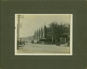 Kew Historical Society Inc
Photograph - Railway level crossing in Glenferrie Road, Glenferrie, E.J. Dower, 1912
One of a series of photographs, taken by Edgar James Dower in the second decade of the twentieth century. Born and raised in Olinda, his family later moved to Surrey Hills. He worked as an adult as a clerk in the city office of the Metropolitan Gas Company, and in his role as a 'collector', he was able to photograph scenes including the construction of tramlines and associated buildings in Kew, Hawthorn, Camberwell and Surrey Hills. Later he established a real estate agency with his brother - the E.J. Dower Real Estate Agency, Dandenong Office.The image is an historically significant record of the development of transport infrastructure which was used to connect Victorians in the first two decades of the twentieth century. This development resulted from increases in population and the consequent extension of Melbourne's suburbs. The photographs, both individually and collectively, richly detail the labour of workers and the tools and machinery used to create and extend Melbourne's public transport network in the years preceding and during World War 1.Digital copy of an original mounted photograph showing Glenferrie Road Hawthorn, looking north towards the old railway level crossing that existed before the line was elevated on a bridge over Glenferrie Road. "The Don Store" at right is immediately behind the old railway level crossing. The tree and shops at left before the crossing were to be removed / demolished as part of the realignment of the train tracks.Annotated verso: "Glenferrie Road, Glenferrie, showing railway gates and Walker's Store / Taken prior to the construction of electric tramline and the regrading of Camberwell Railway Line / Taken by E.J. Dower about 1912".theme --- travelling by tram, theme -- connecting victorians by transport and communications, glenferrie road -- hawthorn (vic.), railways -- hawthorn, the don store -- hawthorn (vic.) -
 Bendigo Historical Society Inc.
Document - DRAINAGE PROBLEMS - NEW CHUM MINES DRAINAGE PROBLEMS 1910
Handwritten extract from the Bendigo Advertiser 20/8/1910 Page 8. ''New Chum Mines. Unwatering of the deep levels is being carried on as expeditionsly as was expected by the authorities. In the last four days, the water has only been lowered 14 feet at the Victoria Quartz Mine. The water stood at the 3,226 feet level yesterday. The slow progress being made this week is no doubt due to the large quantity in the workings at some of the levels.'' From the Bendigo Advertiser 27/8/1910 Page 9. ''New Chum Mines. Very slow progress being made. At Victoria Quartz, the water was lowered 32 feet for the week, and is now at 3258 feet. New Chum Railway lowered the water 17 feet and the present level of the water is at 1796 feet. The Lazarus are raising water from 2157 feet. The water has ceased flowing into the New Chum and Victoria through the connecting level with the Lazarus Mine at about 2,500 feet. As the Victoria Quartz is down 4,614 feet, there is still a considerable quantity of water to get out before sinking of the shaft can be resumed.''document, gold, drainage problems, drainage problems, new chum mines drainage problems 1910, bendigo advertiser 20/8/1910 page 8 & 27/8/1910 page 9, new chum mines, victoria quartz, new chum railway, lazarus, new chum and victoria -
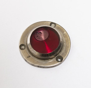 Lorne Historical Society
Tool - Cirkut Panoramic Camera Number 5 spirit level
Used in William Anderson’s Cirkut Panoramic Camera. Silver colored metal disc with circular glass cylinder containing red leveling fluid. The base has three holes to put pins in to attach it to the cameracamera, william anderson, -
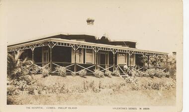 Phillip Island and District Historical Society Inc.
Photograph, Valentine's, First Warley Hospital, Cowes, 1920's
From Jessie Smith's collection. Original Warley Hospital opened in 1923.First Warley Hospital. White fret work verandah head and large white crosses verandah railings. Steps down to ground level centre right.The Hospital, Cowes, Phillip Island. Valentine Series M4909local history, photographs, historic, hospital, cowes phillip island, sepia photograph, public buildings, cowes., jessie smith collection, stan mcfee -
Federation University Historical Collection
Reports, Ballarat Technical School Reports: John Bainbridge, 1974, 1974
John Bainbridge's report indicate that he was in Form 4G1. The "G" indicates that he was doing general subjects. These included English, Social Studies, Mathematics 1, Science 1, as well as Graphics, metal fabrication, Auto Practices and Electical Practices. His reports indicate he had a good degree of understanding and ability. There were reports written at the end of each term. At this time there were only three terms each year. The four term year was introduced into Victorian schools in 1987.Printed subject sheets for teachers to complete on appropriate sections. Section for level of ability to be marked, space for individual comments. Separate sheets stapled together in folder.School name. Subject teacher's signature on each page -
Glenelg Shire Council Cultural Collection
Photograph - Photograph - Main Breakwater construction, Portland, n.d
Port of Portland Authorityport of portland archives, main breakwater, construction, portland harbour, harbour development -
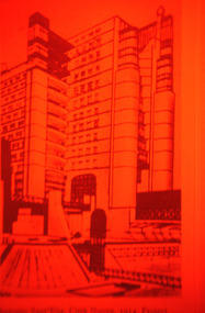 Robin Boyd Foundation
Slide, Robin Boyd, 1967
Colour slide in a mount. Drawing by Antonio Sant’Elia. Housing with external lifts and connection systems to different street levels from La Città Nuova, 1914Made in Australia / 22 / JUN 67M1 / Encircled 1A (Handwritten)slide, robin boyd -
 Queen Victoria Women's Centre
Photograph, c.1995/1996
Colour photograph. From level 3 balcony facing sotuh west over Lonsdale street towards Swanston street. Taken during restoration inspection. historic buildings, building construction -
 Queen Victoria Women's Centre
Photograph, 5 February 1996
Colour photograph. Level one south eastern corridor looking into where in 2015 is a doorway at the wall and where is the archive room. Taken during restoration inspection.historic buildings, building construction -
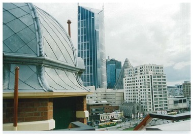
 Queen Victoria Women's Centre
Photograph, c.February 1997
Colour photograph. From level five atrium after completion of renovation works. Taken from the north of the Atrium facing south over Lonsdale street. historic buildings, cultural structures and establishments -
 Queen Victoria Women's Centre
Photograph, c. February 1997
Colour photograph. From rooftop level five. Taken on north west of floor facing towards Swanston street, Melbourne Central and little Lonsdale street. photograph, historical building, cultural structures and establishments -
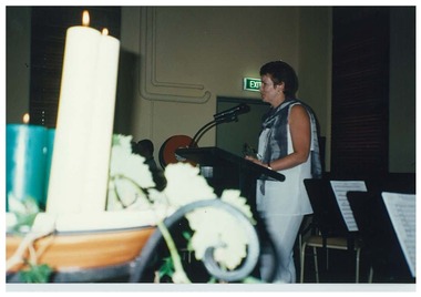 Queen Victoria Women's Centre
Photograph, c. early 1997
Colour photograph. Shilling Fund launch. Janet England, Chair of Trust, addressing the audience. Level four Victoria room QVWC building. Candles in foreground.fundraising events, official events, historic buildings, charitable organisations -
Canterbury History Group
Photograph - Canterbury Railway Station, c1966
Workmen demolishing level crossing on Canterbury Road [1966]. Two storey shops on the right now demolished, one of these was Andrews Antiques. Black and white photographcanterbury, canterbury road, canterbury railway station, railway crossings, andrews antiques -
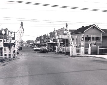 City of Kingston
Photograph - Black and white, Public Transport Corporation, c. 1960
This image is part of a larger collection of images from the Public Transport Corporation displaying train stations and streetscapes in what is now the City of Kingston.Black and white photograph of level crossing at McKinnon railway station with crossing gates open. The image also provides a streetscape which includes businesses and signage.Stamped in blue ink on reverse: COPYRIGHT / Public Transport Corporation / For re-ordering photographs / Please quote negative No PR4762 / Enquiries C/- PTC Photographic Unit / Telephone switchboard 619 111mckinnon, suburbs, railway station, streetscape, shopping strip