Showing 1482 items
matching looking east
-
 Federation University Historical Collection
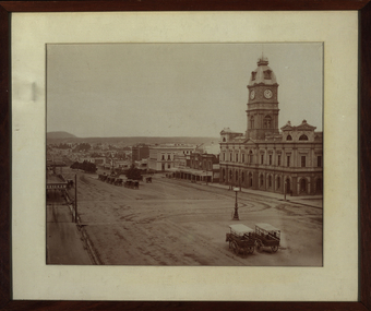
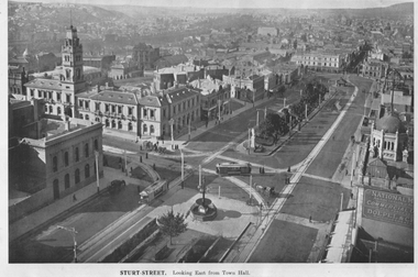
Photograph - Black and White Photograph, Sturt Street Ballarat - Looking East, 1872
... Sturt Street Ballarat - Looking East ... on the right hand side. Sturt Street Ballarat - Looking East Photograph ...Framed black and white photograph of Sturt Street Ballarat showing the Ballarat Town Hall on the right hand side. ballarat, ballarat townscape, ballarat streetscape, ballarat town hall, architecture, tower, carriage, horse, lamp, bluestone, william bardwell, fotobiennale, mount warrenheip -
 Ringwood and District Historical Society
Photograph, Maroondah Highway West, Ringwood- 1969. Looking east from Heatherdale Road
... Maroondah Highway West, Ringwood- 1969. Looking east from..., Ringwood- 1969. Looking east from Heatherdale Road. Photograph ...Black and white photographWritten on back of photograph: "May 1969. Eastern view from corner of Maroondah Highway and Heatherdale Road." -
 Ringwood and District Historical Society
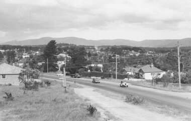
Photograph, Maroondah Highway West, Ringwood- c1940's. Looking east from Heatherdale Road
... Maroondah Highway West, Ringwood- c1940's. Looking east... Maroondah Highway West, Ringwood- c1940's. Looking east from ...Black and white photographWritten on back of photograph: "See booklet- 'Welcome to Ringwood' 1948/1949".(Which shows identical image on front cover). -
 Ringwood and District Historical Society
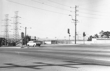
Photograph, Maroondah Highway West, Ringwood- 1969. Looking east from Heatherdale Road
... Maroondah Highway West, Ringwood- 1969. Looking east from...- 1969. Looking east from Heatherdale Road. Photograph ...Black and white photographWritten on back of photograph: "May 1969" Image shows pylons for high voltage power lines. -
 Ringwood and District Historical Society
Photograph, Maroondah Highway West, Ringwood- 1969. Looking east from Heatherdale Road
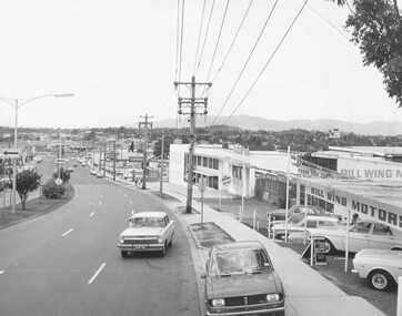
... Maroondah Highway West, Ringwood- 1969. Looking east from..., Ringwood- 1969. Looking east from Heatherdale Road. Photograph ...Black and white photographImage taken from front of 'Bill Wing Motors'. -
 Ringwood and District Historical Society
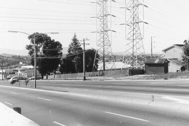
Photograph, Maroondah Highway West, Ringwood- 1969. Looking east from Heatherdale Road
... Maroondah Highway West, Ringwood- 1969. Looking east from...: "May 1969" Maroondah Highway West, Ringwood- 1969. Looking east ...Written on back of photograph: "May 1969" -
 Ringwood and District Historical Society
Photograph, Maroondah Highway West, Ringwood- 1969. Looking east from near Heatherdale Road
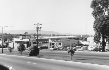
... Maroondah Highway West, Ringwood- 1969. Looking east from... West, Ringwood- 1969. Looking east from near Heatherdale Road ...Black and white photographWritten on back of photograph: "May 1969" Image shows 'Bill Patterson Motors' used car yard, and 'Lowline Caravans'. -
 Ringwood and District Historical Society
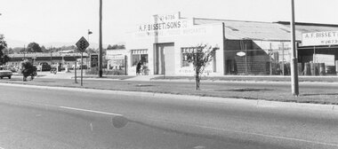
Photograph, Maroondah Highway West, Ringwood- 1969. Looking east from near E. Hassett & Sons
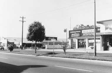
... Maroondah Highway West, Ringwood- 1969. Looking east from... West, Ringwood- 1969. Looking east from near E. Hassett & Sons ...Black and white photographWritten on back of photograph: "May 1969". Image also shows 'A. F. Bisset & Sons', and 'Heatherdale Pharmacy'. -
 Ringwood and District Historical Society
Photograph, Maroondah Highway West, Ringwood-1969. Looking east from A. F. Bisset & Sons
... Maroondah Highway West, Ringwood-1969. Looking east from A..., Ringwood-1969. Looking east from A. F. Bisset & Sons. Photograph ...Black and white photographWritten on back of photograph: "May 1969" -
 Ringwood and District Historical Society
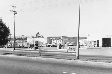
Photograph, Maroondah Highway West, Ringwood- 1969. Looking east from near New Street
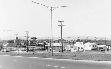
... Maroondah Highway West, Ringwood- 1969. Looking east from..., Ringwood- 1969. Looking east from near New Street. Photograph ...Black and white photographWritten on back of photograph: "May 1969". Image shows Mazda showrooms and Mobil Service Station. -
 Ringwood and District Historical Society
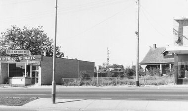
Photograph, Maroondah Highway West, Ringwood- 1969. Looking east from near Wantirna Road
... Maroondah Highway West, Ringwood- 1969. Looking east from..., Ringwood- 1969. Looking east from near Wantirna Road. Photograph ...Black and white photographWritten on back of photograph: "May 1969". Image shows 'Bank of New South Wales' on south side of highway. -
 Ringwood and District Historical Society
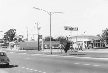
Photograph, Maroondah Highway West, Ringwood- 1969. Looking east near Wantirna Road
... Maroondah Highway West, Ringwood- 1969. Looking east near..., Ringwood- 1969. Looking east near Wantirna Road. Photograph ...Black and white photographWritten on back of photograph: "May 1969". Image shows 'Seaboard Finance', and 'Shell Service Station'. -
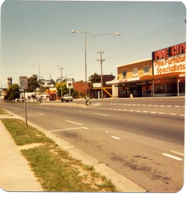 Ringwood and District Historical Society
Photograph, Pine City and Ringwood Arcade (88 Maroondah Hwy) looking East c1979
... Pine City and Ringwood Arcade (88 Maroondah Hwy) looking... Hwy) looking East c1979 Photograph ...Colour photograph taken by Richard Carter, c1979 -
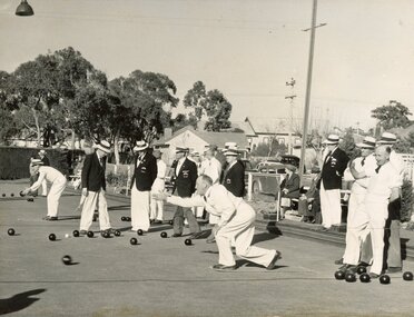 Ringwood and District Historical Society
Photograph, Ringwood Bowls Club - Opening day in the 1953-54 season at the Miles Avenue green, looking East, showing bowlers competing on the green
... the Miles Avenue green, looking East, showing bowlers... green, looking East, showing bowlers competing on the green ...Black and white photograph"Written on back of photograph" Opening Day, 1953-54. -
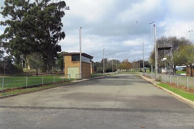 Stawell Historical Society Inc
Photograph, Fire Brigade Training Track at North Park 2015 Looking East
... Fire Brigade Training Track at North Park 2015 Looking East... 2015 Looking East Photograph ...Fire Brigade Training Track – North Park - 2015Colour Photograph of bitumen track used for fire fighting training. Looking weststawell -
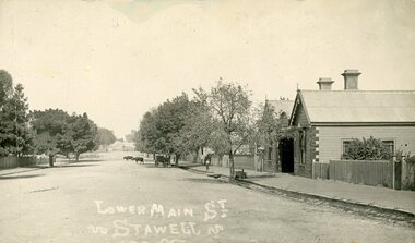 Stawell Historical Society Inc
Photograph, Lower Main Street Stawell. c1905 Looking East towards Railway Line. railway Hotel on Right
... Lower Main Street Stawell. c1905 Looking East towards... Hotel on Right. Lower Main Street Stawell. c1905 Looking East ...Lower Main Street. with Railway Hotel on Right. c1905.Postcard. Lower Main Street. Two Bullocks in teh distance, A Carriage under a tree on the right side of Main Street, and a child on the footpath. Railway Hotel on Right.LOwer Main St.stawell transport streetscape -
 Stawell Historical Society Inc
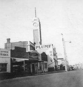
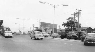
Photograph, Main Street Stawell looking East c1950
... Main Street Stawell looking East c1950... Street Stawell looking East c1950 Photograph ...Main street scene, 1950's vehicle parked in street on right. "Plume" building is McClure's Main St Stawell. Town Hall clock tower in center. H L. Rasmussen Pianos & Players shop at center, McClure's Garage. stawell shops businesses streetscape -
 Malmsbury Historical Society
Photograph (Item), Malmsbury Station Looking East, Malmsbury ca1980
... Malmsbury Station Looking East, Malmsbury ca1980...-ranges Buildings - Malmsbury Station Malmsbury Station Looking ...Buildings - Malmsbury Station -
 City of Ballarat Libraries
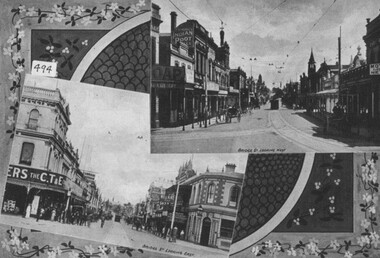
Photograph - Card Box Photographs, Views looking east and west along Bridge Street, Ballarat c1915
... Views looking east and west along Bridge Street, Ballarat... homecoming Views looking east and west along Bridge Street, Ballarat ...East and west views along Bridge Street. Buildings along the streets include Cowdell Tonner & Ellis and the Bucks Head Hotel. This comes from the Ballarat Homecoming publication.bridge street, ballarat, streetscape, buildings, cowdell tonner & ellis, bucks head hotel, public, commerical, hotel, ballarat homecoming -
 Ballarat Heritage Services
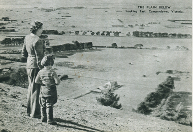
Image - Black and White, Camperdown Looking East, c1950, c1950
... Camperdown Looking East, c1950..., Victoria. Camperdown Looking East, c1950 Image - Black and White ...A women and a child stand on a high vantage point and look over the the countryside around Camperdown, Victoria.camperdown -
 Inverloch Historical Society
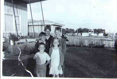
000866 - Photograph - 1952 - Inverloch - five children in front of house - 37 Bayview Ave looking east towards Corsair Ave - from Hazel Swift
... front of house - 37 Bayview Ave looking east towards Corsair Ave... children in front of house - 37 Bayview Ave looking east towards ... -
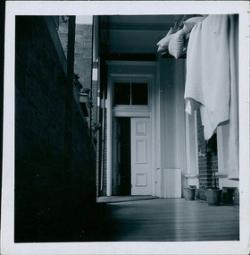 Department of Health and Human Services
Photograph, Bedding being aired on the North verandah, looking East, on the ground floor of the Ballarat Base Hospital, photo take on 13/02/1959 - 4 of 4 photos - Regional & District Hospital Collection - Department of Health & Human Services (DHHS)
... Bedding being aired on the North verandah, looking East, on..., looking East, on the ground floor of the Ballarat Base Hospital ...Photo is part of the Department of Health, Building & Services Division, Facilities Development - Hospitals - Photographic Inventory -
 Ballarat Tramway Museum
Photograph - Illustration, "Sturt Street looking east from Town Hall", c1907
... "Sturt Street looking east from Town Hall"... a magazine or publication "Sturt Street looking east from Town Hall ...The illustration looks northeast from Town Hall overlooking the intersection of Sturt and Lydiard Streets, towards Black Hill and Grenville St. Has two ESCo trams in view, both with roof-mounted destinations, Post Office, and the Grenville St shelter. C1907. Has the National Mutual building in the bottom right-hand corner advertising Commercial Unity and Doepel & Co.Yields information about the intersection of Sturt and Lydiard Streets and associated buildings.Illustration cut from a magazine or publicationballarat, illustrations, post office, sturt st, lydiard st, esco -
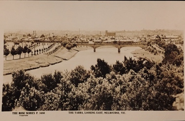 Kew Historical Society Inc
Postcard, Rose Stereograph Company, The Yarra Looking East, Melbourne, Vic
... The Yarra Looking East, Melbourne, Vic. ... Looking East, Melbourne, Vic. Postcard Rose Stereograph Company ...One of a number of 'real photo' and commercial postcards created by or owned by members of the Christian and Washfold families of Kew. The postcards are part of a larger collection of photographs, postcards and publications donated to the collection in May 2021.View of Melbourne on the horizon, looking in an easterly direction along the River Yarra. A State Library of Victoria catalogue record says ‘Elevated view along Yarra River, trees in foreground, line of saplings along both banks of the river, bridge in background (possibly Johnson Street Bridge)’. This may be incorrect.The Rose Series P. 3480yarra river -- melbourne, postcards -- yarra river, the rose series postcards, christian-washfold collection -
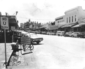 Stawell Historical Society Inc
Photograph, Upper Main Street Looking East when closed for construction of Pedestrian Mall 1978
... Upper Main Street Looking East when closed for construction... Looking East when closed for construction of Pedestrian Mall 1978 ...Main Street with Closure Warning Sign 1978 from Post Office Corner.stawell business streetscape -
 Surrey Hills Historical Society Collection
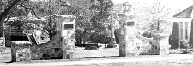
Photograph, View of Surrey Gardens looking east from Union Road
... View of Surrey Gardens looking east from Union Road... can be seen. View of Surrey Gardens looking east from Union ...The 2 cannons in the gardens were acquired by Mr Arthur Brookes, popularly known as 'Empire Brookes'. They were from a British vessel used during the Crimean War and were originally placed in the grounds of the Guildford Road Recreation Oval. The Dimmick Gateway was erected in 1950 by the citizens of Camberwell in memory of Cr William Dimmick, JP, Mayor of Camberwell, 1935-1936 and a Councillor from 1934-1947. There is a photo of him in Mayoral robes in the City of Boroondara Library Service collection. Cr Dimmick was commonly called Roy.Black and white photo of the Dimmick Gateway in Surrey Gardens. The gateway is built as if it was designed to have a fence attached but there is none. There are 2 tall central pillars and an arched bridge to 2 smaller pillars. It appears to be constructed from a variegated slate material. There is a light on the top of each of the tall pillars and also a plaque. To the RHS of the photo is part of the Surrey Shrine, skirted by 2 cypress trees. A canon and the Memorial Cross can be seen between the gateway pillars and to the LHS of the photo the wooden bandstand can be seen.dimmick gateway, surrey gardens, surrey shrine, boer war, bandstand, parks and reserves, cr william dimmick, roy dimmick -
 Linton and District Historical Society Inc
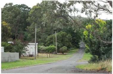
Photograph, Looking East, Clyde Street, Linton, 2014
... Looking East, Clyde Street, Linton, 2014 ... cement-sheet building, the Telstra exchange at Linton. Looking ...From 1898 until the 1940s, the 'Grenville Standard' newspaper building was located approximately where the Telstra building is. The RSL hall was afterwards on this site, until it also was demolished in 1996.Colour photograph which shows a tree-lined road. On the left is a small cement-sheet building, the Telstra exchange at Linton.clyde street linton, site of grenville standard building linton, site of rsl hall linton -
 Clunes Museum
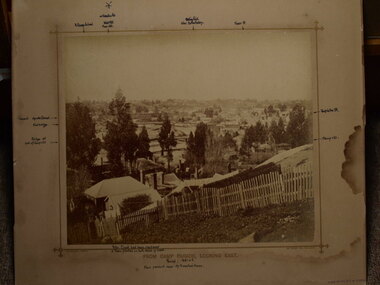
photograph, FROM CAMP PARADE, LOOKING EAST
... FROM CAMP PARADE, LOOKING EAST... FROM CAMP PARADE, LOOKING EAST photograph PHOTOGRAPH ...PHOTOGRAPH OF CLUNES TOWNSHIP - FRASER STREET FROM CREEK PARADE, CLUNES. C1876 .1 BLACK AND WHITE MOUNTED ON CARDBOARDF .2 BLACK AND WHITE PHOTO PRINT .3 BLACK AND WHITE PHOTO PRINT .4 BLACK AND WHITE PHOTO PRINT .5 BLACK AND WHITE PHOTO PRINT .6 BLACK AND WHITE PHOTO PRINT .7 SMALL BLACK AND WHITE PHOTO PRINT .8 SMALL BLACK AND WHITE PHOTO PRINT .9 SMALL BLACK AND WHITE PHOTO PRINT .10 B LACK AND WHITE PHOTO PRINT .11 SEPIA MOUNTED PHOTO WITH POINTS OF INTEREST WRITTEN ON MOUNTING .12 SEPIA MOUNTED PHOTOlocal history, photography, photographs, clunes township -
 Ringwood and District Historical Society
Photograph, Edwin G. Adamson A.R.P.S, Maroondah Highway Central, Ringwood. Looking east from Ringwood Street 1963. (Eastland Litigation Photo), May 1963
... Maroondah Highway Central, Ringwood. Looking east from... Maroondah Highway Central, Ringwood. Looking east from Ringwood ...This series of SS0380 photos are part of the "Eastland Litigation" launched in 1962 by the Whitehorse Traders Co-operative Association (WTCA), against the Ringwood Council's Interim Development Order of 1960. WTCA sought "orders from the Supreme Court of Victoria that the planning scheme was invalid" - See "The Eastland Litigation" chapter in "From Horse Shoes to High Heels - Ringwood Shopping Centre and Eastland 1858-2008" by Richard Carter, Bounce Books 2009.Black and white photographWritten on back of photograph: "Photo showing cars parked and travelling along M'dah Hway" Stamped on back of photograph, 'Edwin G. Adamson...May 63'. -
Merbein District Historical Society
Photograph, Merbein Township- Looking east towards Pumping Station, 1936
... Merbein Township- Looking east towards Pumping Station... Merbein Township- Looking east towards Pumping Station Photograph ...river avenue (taken from water tower), chaffey park tennis courts