Showing 3152 items matching "miles"
-
 Bendigo Military Museum
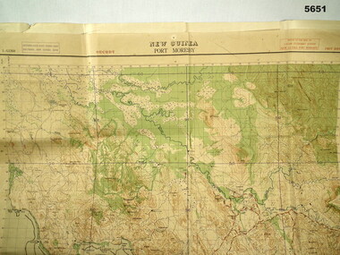
Map - MAP, PORT MORESBY 1943, 2/1st Aust Army TOPO SVY Coy, March 1943
In the collection re Capt R.A. Hanson VX111070, refer cat No 5646.3P for his service details.Map, Port Moresby area, colour, detailed, scale 1" - 1 mile, first Edition.In red, "1:63360 Standard series New Guinea, Port Moresby"map, new guinea, port moresby -
 Ringwood and District Historical Society
Envelope, Packet: Ringwood Thrip Investigation League Report 1932, c.1932
Thrip - Letter and report from the Victorian Fruit Marketing Assoc. +Additional Keywords: Miles / Aird -
 Otway Districts Historical Society
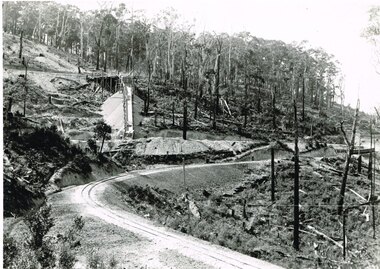
Photograph, Beechy: At 10 mile creek, 1900
At 10 mile creek (Water Tanks) during the building of the Colac-Beech Forest railway in 1900.colac; beech forest; railway; 10 mile creek; water tanks; -
 Otway Districts Historical Society
Photograph, Victorian Railways, Gellibrand ballast pit siding, c.1902
In 1902 a ballast siding was opened 4 km south of Gellibrand to provide materials for track construction. A spur siding with a capacity for six trucks was cut into the side of a slope. Above this was erected a loading bin and chute. The stone proved to be of durable quality so the siding continued after 1902 for periodic track re-ballasting works. The points were set for the main line and spiked shut when the siding was not in use. By the mid-1920s the Victorian Railways found it more economic to use ballast from Penshurst, so the siding was closed by 1925 and the rails lifted.B/W. Gellibrand ballast pit siding at 19 miles (30.6 km) south of Colac. gellibrand; gellibrand siding; railways; -
Canterbury History Group
Document - "Hazeldene" land title, 1932
Certificate of title of" Hazeldene" dated 12 December 1932 Transfer to Annie and Frederick Miles Dankscanterbury, balwyn road, "hazeldene", danks family, certificates -
Port Melbourne Historical & Preservation Society
Audio - Architectural development, Miles Lewis, John Kirby, 26 Aug 2013
Miles Lewis talks on architectural development and building trends in historical geographical areas. Duration 50'11"built environment, miles lewis, architecture -
 Lakes Entrance Historical Society
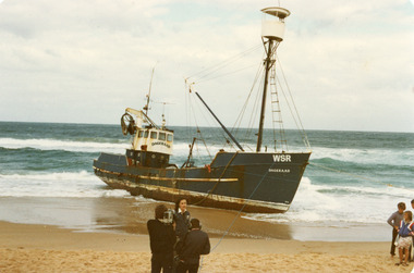
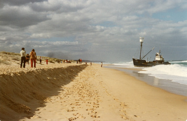
Photograph - Dageraad, 1981
Vessel stranded 26 April 1981Colour photograph of the fishing vessel Dagaraad aground on the ninety mile beach beside the entrance barships and shipping, fishing industry, coast, shipwrecks -
 Lakes Entrance Historical Society
Photograph - Dageraad, 1981
Vessel stranded 26 April 1981Colour photograph of the fishing vessel Dagaraad aground on the ninety mile beach beside the entrance barships and shipping, fishing industry, coast, shipwrecks -
 Lakes Entrance Historical Society
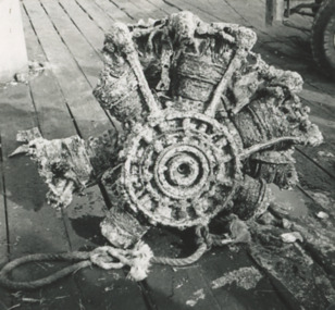
Photograph - Aircraft engine found by fishing boat Anne Liese Lakes Entrance 1993
part of an aircraft engine dredged up from the ocean floor four nautical miles west of the Entrance by fishing boat Anne Liese, skipper Matt Jenkins pictured on Eastern Wharf Lakes Entrance Victoria 1993 Also black and white photograph of two adults and three children watching activities of the fishing fleet at the wharf Black and white photograph of part of an aircraft engine dredged up from the ocean floor four nautical miles west of the Entrance by fishing boat Anne Liese, skipper Matt Jenkins pictured on Eastern Wharf Lakes Entrance Victoria. Also black and white photograph of two adults and three children watching activities of the fishing fleet at the wharf 1993 boats and boating, aircraft, discovery -
Bendigo Historical Society Inc.
Map - CAMPBELL COLLECTION: BENDIGO AND DISTRICT MAPS, 8-2-29
Map. Bagshot, Parishes of Wellsford, Ellesmere, and Bagshot. Huntly 4 miles, Fosterville 3 miles. Total area 5037 acres, Prepared in W.P.B. from A.C.L and D.B. Plans, by W.J.Galbraith 8-2-29. (number 382 in map cupboard 1).W.J.Galbraithmap, bendigo, agricultural lands -
 Bendigo Military Museum
Map - Australian Topographical Survey NAGAMBIE SW Sheet, 1 inch:1 Mile, NW portion Plane Table Field sheet 1921, Australian Survey Corps, 1921
This is a coloured reproduction print of an original Plane Table compilation map sheet of Nagambie area 1inch to 1 Mile scale compiled by Sgt Jack Cullen Australian Survey Corps 30 September 1921. Jack was one of the foundation members of the Australian Survey Corps. Of particular interest is the fact that this is a heighted compilation with contouring (required for Military use) as many early maps were purely planimetric. A table on the right hand side details the number of days that it took to produce the compilation. The reverse side of this print is a copy of the Tallarook plane table South East field sheet.Reprinted coloured Image of Australian Topographical Survey NAGAMBIE SW Sheet,1 inch:1 Mile, NW portion hand drawn Plane Table Field sheet. Includes an itemized summary of work, signed by Sgt J Cullen Australian Survey Corps September1921.royal australian survey corps, rasvy, fortuna, army survey regiment, army svy regt, asr -
Ringwood and District Historical Society
Programmes, Ringwood Silver Jubilee Celebrations 1924-1929: Program, Dec-49
Programme produced for the Ringwood Silver Jubilee Celebrations 1924-1929 held in the Town Hall, Ringwood on 15-Dec-1949 at 8 p.m. MR A.T. Miles, first mayor of the borough and Cr. J.K. McCaskill, the only sitting councillor from the original council of 1924 were present and spoke.Programme produced for the Ringwood Silver Jubilee Celebrations 1924-1929 held in the Town Hall, Ringwood on 15-Dec-1949 at 8 p.m. MR A.T. Miles, first mayor of the borough and Cr. J.K. McCaskill, the only sitting councillor from the original council of 1924 were present and spoke.; The programme is cream coloured bi-fold with blue printing with the Borough crest on the front. -
Greensborough Historical Society
Map, Victoria: Yan Yean, prep. by Australian Section of Imperial General Staff, 1935
Part of 1:63,360 series of survey mapsColour copy from original. Scale: 1: 63,360 (1 inch to 1 mile) 2 copiesRev. 1930 by Australian Survey Corps using RAAF Air Photos. yan yean -
Glenelg Shire Council Cultural Collection
Map, 1885
Significant collection relating to the social history across the shire.Map, Victoria. Skeleton map of Telegraph Circuits and Railways 1885. Scale 16 miles to 1 inch.map, skeleton map, telegraph, railways, 1885, 1880s -
Whitehorse Historical Society Inc.
Pamphlet - Newsletter, Urban design framework, 2010
City of Whitehorse Bulletin No.3 featuring a vision for Mega Mile (West) and the Blackburn Neighbourhood Activity Centre.City of Whitehorse Bulletin No.3 featuring a vision for Mega Mile (West) and the Blackburn Neighbourhood Activity Centre.City of Whitehorse Bulletin No.3 featuring a vision for Mega Mile (West) and the Blackburn Neighbourhood Activity Centre.blackburn neighbourhood activity centre, city of whitehorse, mega mile (west) -
 Lakes Entrance Historical Society
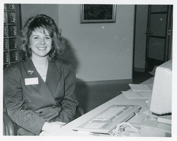
Photograph - Tambo Shire Office, Lakes Post Newspaper, 1993
Black and White Photograph of Amanda Miles Customer Service officer 1993 Tambo Shire Gippsland Victoriamuincipal history -
 Bendigo Historical Society Inc.
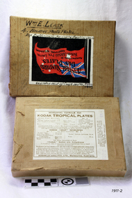
Document - ERROL BOVAIRD COLLECTION: DODGE LUBRICATION CHART
Fold out Lubrication Chart for Dodge Brothers Motor Vehicles. Printed in the U.S.A. on cream paper with black card measuring 21.1 x 14.0 for backing when it is folded. Chart has picture of the chassis, engine and wheels and is colour coded. Green for 500 miles or less, Blue for 1000 miles, red for 2000 miles and black for season. Each lubrication point has a circle where it is situated and a line to the name and which oil or grease.document, john bovaird collection - dodge lubrication chart, dodge brothers -
 Victorian Harness Racing Heritage Collection at Lord's Raceway Bendigo
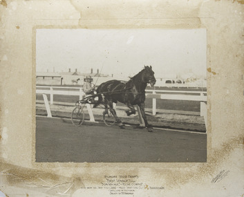
Photograph - Mounted photo, Sutcliffe & Akers, Belmont Stud Farm's, First Voyage, 1915
First Voyage won the first £200 2 mile Trotting Cups in successions, contested in Victoria, driven by T HardmanLarge rectangular black and white photo of horse and driver mounted on cream paper.Centered at the bottom: Belmont Stud Farm's / "First Voyage" (Imp) / "Bon Voyage," - "Elsie Downs" / Who won the first two (£200) 2 mile trotting cups in succession / Contested in Victoria / Driven by T.R. Hardman Bottom right corner: Sutcliffe & Akers / Cromwell Bldgs / 366A Bourke St / Melbournetrotting, first voyage, belmont stud farms, bon voyage, elsie downs, t.r. hardman, brian glasheen -
 Bendigo Historical Society Inc.
Photograph - BENDIGO ADVERTISER COLLECTION: ATHLETICS
Black and white photograph, athletics, close-up photograph of Anne Cross who is a 5 Time winner of the Dragon 12 Mile Open Bendigo Advertiser description: 4/4 AH Dragon Mile Open Womens winner Anne Cross 5 time winnerrecreations, sports, athletics, anne cross. -
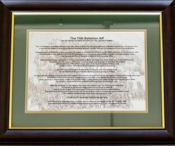 Lara RSL Sub Branch
Picture, The 11th Battalion AIF at Cheops
Details of the famous 11 Battalion photo posing on the Cheops Pyramid at Mena 10 miles from Cairo. Also includes a brief history of the Battalion campaigns. Background watermark of the photo of troops on the pyramid. The Battalion returned to Australia at the end of war and was disbanded on 6th of February 1919. Awarded a Kings colour for its service.Famous photo of the 11th Battalion (800 men) posing on the Cheops Pyramid on the 10th of January 1915.Rectangular framed print which describes the famous photo of the 11th AIF Battalion posing on the cheops pyramid (Catalogue item 807)Printed details of the famous 11 Battalion photo posing on the Cheops Pyramid at Mena 10 miles from Cairo. Also includes a brief history of the Battalion campaigns. Background watermark of the photo of troops on the pyramid11th battalion cairo cheops blackboy hill cheops cairo egypt ypres somme -
Stawell Historical Society Inc
Map - Electoral Map, Federal Government, map of Commonwealth Electoral Division of Wimmera 1949, 1949
Electoral MapMap overprinted with Electoral Divisions in Red. Description of Division of Wimmera Scale in Miles. Commonwealth of Australia State of Victoriagovernment -
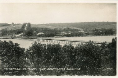 Lakes Entrance Historical Society
Postcard - Footbridge, No14 Bulmer HD, 1940c
1 same image 6.5x10.5 valentine Series donated by Keith West|1 other similar image 6.5 x 10.5|1 other similar image 9 x 14|1 other similar postcard, message on back in Spares BoxBlack and white small format postcard of the footbridge across the Cunninghame Arm, which is the access to the southern shore and ocean beach from the town. Lakes Entrance VictoriaFootbridge to Ninety Mile Beach, Lakes Entrance bridges, waterways, township -
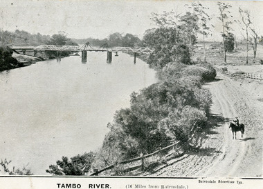 Lakes Entrance Historical Society
Postcard - Bridges, 1906
First timber road bridge over the Tambo River at Swan Reach officially opened 20 December 1905, after which punt was removed to BairnsdaleBlack and white postcard of the lifting bridge over the Tambo River at Swan Reach, Victoria. Man on horse standing on dirt road to Metung beside the river. Punt previously used to cross river visible against western bank of river.Tambo River (16 miles from Bairnsdale)bridges, waterways -
Glenelg Shire Council Cultural Collection
Negative - Negative - Sapling Creek, Nelson, Victoria, c. 1936
Transparency for black and white photo. Entrance to the scrub near Sapling Creek, 7 miles from Nelson Vic -
 Flagstaff Hill Maritime Museum and Village
Photographic Plates
Photographic negative plates of the Buttermere 600 miles west of Cape Horn Feb 4 1887. Box of 4 flagstaff hill, warrnambool, shipwrecked-coast, flagstaff-hill, flagstaff-hill-maritime-museum, maritime-museum, shipwreck-coast, flagstaff-hill-maritime-village, photographic negative plates, photographic, negative plates -
 Ringwood and District Historical Society
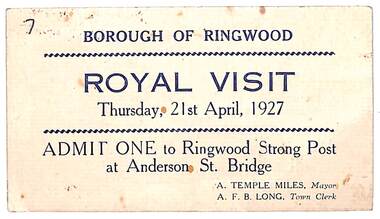
Card, Royal Visit 21st April 1927. Admission Ticket to Ringwood Strong Post at Anderson St. Bridge
Buff coloured ticket issued by A.T. Miles Mayor and A.F.B. Long, Town Clerk, Borough of Ringwood, Victoria. -
 Clunes Museum
Photograph
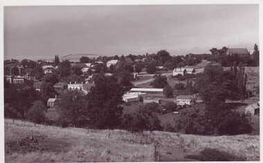
BLACK & WHITE PANORAMIC VIEW OF CLUNES TAKEN FROM SCENIC ROAD LOOKING TOWARDS TWO MILE HILLlocal history, photography, photographs, clunes township -
 Moorabbin Air Museum
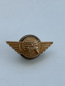
Badge (Item) - United Airlines 100,000 Mile Club Member Lapel Pin
-
 The 5th/6th Battalion Royal Victoria Regiment Historical Collection
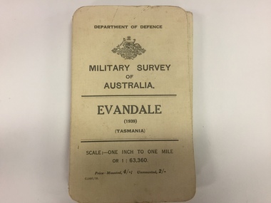
Map, Military Survey of Australia. Evandale (1939) (Tasmania), 1939
Fabric backed colour map, with card cover that folds into a small book. Scale one inch= one mile.military, survey, map, tasmania, ww2, wark vc club -
 Clunes Museum
Photograph
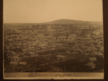
BLACK & WHITE PHOTOGRAPH - MOUNTED - GENERAL VIEW OF CLUNES IN THE EARLY 1860'S , LOOKING TO TWO MILE HILL.local history, photography, photographs, clunes landscape