Showing 670 items matching "mine shaft"
-
 Bendigo Historical Society Inc.
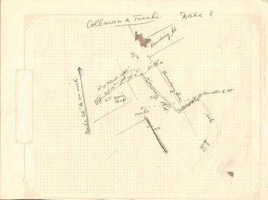
Document - COLLMAN & TACCHE - MAP
Hand drawn map on heavyweight decorated graph paper. Map has parts of Mt. Korong Rd. and Dowding St. drawn in. Broken line drawn from Lansells C & T to Iron Pin. Further away another line drawn from C & T Main Shaft to a point 67 ft 10 in. away, then 78 ft 10 in away, then another point 60 ft 3.5 in away. No date on drawing. Drawn on decorated graph paper, Lawson Series printed by Lawson & Bray (Sales) 58 Margaret Street, Sydney.mine, gold, collman & tacche, collman & tacche, map, lansells c & t, mt korong rd, dowding st. -
 Bendigo Historical Society Inc.
Document - CENTRAL RED, WHITE AND BLUE MINE - NOTES ON THE CENTRAL RED, WHITE AND BLUE MINE
Seven pages of hand written notes on the Central Red, White and Blue Mine. Information on how the mine was obtained and geological information. Initialled AR.mine, gold, central red, white and blue mine, central red, white and blue mine, notes on the central red, white and blue mine, lansell's little 180, eadie's, sheepshead reef, mr g w lansell, central blue, cr t c pryor, delbridge (manning's) shaft, garden gully line, hustlers line, ar -
 Bendigo Historical Society Inc.
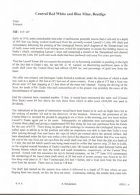
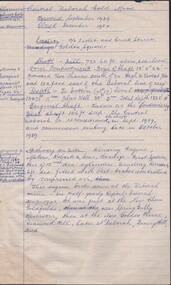
Document - CENTRAL RED, WHITE AND BLUE MINE - LOCALITY AND PLANT OF THE CENTRAL RED, WHITE AND BLUE MINE
... Sheepshead Line of Reef Flying Fox Delbridge or Mannings Shaft Mines ...Three typed copies of notes on the Central Red, White and Blue Mine. Notes give locality, plant, gold produced and where the gold was obtained from. One copy has 'Typed at Mines Dept' written at the top and has a correction in the locality area. It is signed by A Richardson.mine, gold, central red, white and blue mine, central red, white and blue mine, locality and plant of the central red, white and blue mine, sheepshead line of reef, flying fox, delbridge or mannings shaft, mines dept. booklet 'bendigo goldfield' 1936, annals of bendigo mining sections 1910 - 1936, a richardson -
 Bendigo Historical Society Inc.
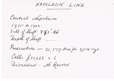
Document - CENTRAL NAPOLEON MINE - NOTES ON CENTRAL NAPOLEON MINE
Hand written notes on cream paper. Years from 1935 to1942. Lists the Sill of Shaft depth, Production and Calls.mine, gold, central napoleon mine, central napoleon mine, napoleon line -
 Bendigo Historical Society Inc.
Document - CENTRAL DEBORAH GOLD MINE - HISTORY OF CENTRAL DEBORAH GOLD MINE 1939 - 1954
4 typed pages of the history of the Central Deborah Gold Mine from 1939 to 1954. Mentions the start of mining at this site and Victor Pabst, who in 1917 recommended that the shaft be deepened. His advice was not acted on for another twenty-two years. Also mentioned is the geology and Method of Mining.mine, gold, central deborah gold mine, central deborah gold mine, history of central deborah gold mine, geology of the central deborah gold mine, method of mining -
 Bendigo Historical Society Inc.
Document - CENTRAL DEBORAH GOLD MINE - NOTES ON CENTRAL DEBORAH GOLD MINE
2 copies of notes on the Central Deborah Gold Mine, 1 hand written and 1 carbon copy. Notes include Locality, the Shaft and it's depth, the Original Shaft and a Winding Engine which had been at several other sites.mine, gold, central deborah gold mine, central deborah gold mine, notes on central deborah gold mine, winding engine, roberts & sons, new chum goldfields, new golden fleece, deborah -
 Bendigo Historical Society Inc.
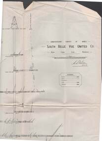
Map - STRUGNELL COLLECTION: UNDERGROUND SURVEY OF MINES, BENDIGO, 29-3-01
Map, Underground Survey of Mines, Bendigo, South Belle Vue United Co.,New Chum Line.Transverse Section. Signed H.S.Whitelaw29.3.01 Drawing appears to show samples of connecting horizontal shafts with their respective mineral contentsH.S.Whitelawmap, bendigo, south belle vue united co.. -
 Bendigo Historical Society Inc.
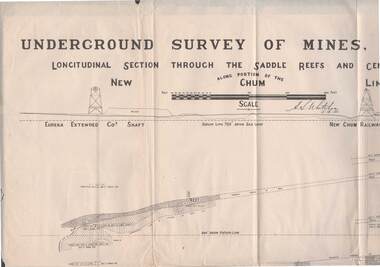
Map - STRUGNELL COLLECTION: NEW CHUM LINE OF REEF, 5/4/01
Map, Along portion of the New Chum Line, Underground Survey of Mines, Bendigo, Longitudinal Section through the Saddle Reefs and Centre Country. Eureka Extended Co's shaft, New Chum Railway Co's shaft. Surveyed under the supervision of H.Herman, B.C.E., F.G.S., Acting Government Geologist.H.S.Whitelowmap, bendigo, new chum line -
 Bendigo Historical Society Inc.
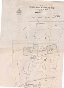
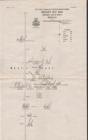
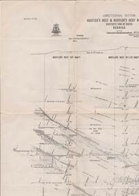
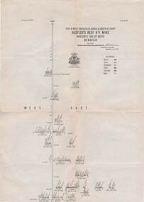
Map - STRUGNELL COLLECTION: HUSTLER'S LINE OF REEFS, BENDIGO, September 1913
Map, Hustler's Line of Reefs, Hustler's Royal Reserve No. 2 Mine, Bendigo.Plate No. V (5).. Great Extended Hustler's Lease, Imperial Hustler's, Hustler's Royal Reserve No. 2 Park & Main Shafts, Fortuna Hustler's Lease.Bulletin No 33 Signed H.A.Whitelaw Underground survey Office Bendigo September 1913Underground Survey Office, Bendigo.map, bendigo, hustler's royal reserve no. 2 mine* -
 Bendigo Historical Society Inc.
Map - STRUGNELL COLLECTION: HUSTLER'S LINE OF REEFS, BENDIGO, September 1913
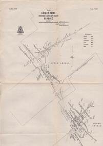
Map, Hustler's Line of Reefs, Comet Mine, Bendigo Plan.Plate No.XX1V (24). Map, Bulletin No 33 Signed H.A.Whitelaw Underground survey Office Bendigo September 1913 Drawing shows upper and lower levels and appears to show samples of connecting horizontal shafts with their respective mineral contentsUnderground Survey Office, Bendigo.map, bendigo, comet mine -
 Bendigo Historical Society Inc.
Map - STRUGNELL COLLECTION: HUSTLER'S LINE OF REEFS, BENDIGO, September 1913
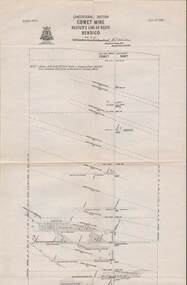
Map, Hustler's Line of Reefs, Comet Mine, Longitudinal Section.Plate No.XXV1 (26).Bulletin No 33 Signed H.A.Whitelaw Underground survey Office Bendigo September 1913 Drawing shows the vertical shaft descending to over 1692 feetUnderground Survey Office, Bendigo.map, bendigo, comet mine -
 Bendigo Historical Society Inc.
Map - STRUGNELL COLLECTION: HUSTLER'S LINE OF REEFS, BENDIGO, September 1913
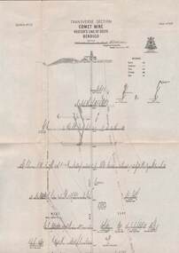
Map, Hustler's Line of Reefs, Comet Mine, Transverse Section, Plate No.XXV (25). Bulletin No 33 Signed H.A.Whitelaw. Drawing shows the vertical shaft descending to over 1692 feet and appears to show samples of connecting horizontal shafts with their respective mineral contentsUnderground Survey Office, Bendigo.map, bendigo, comet mine -
 Bendigo Historical Society Inc.
Map - STRUGNELL COLLECTION: HUSTLER'S LINE OF REEFS, BENDIGO, September 1913
Map, Hustler's Line of Reefs, Hustler's Reef Mine, East & West Cross-Cuts, North & South of Shaft. Plate No. X1X (19).Bulletin No 33 Signed H.A.Whitelaw. Drawing shows the vertical shaft descending to over 1296 feet and appears to show samples of connecting horizontal shafts with their respective mineral contentsUnderground Survey Office, Bendigo.map, bendigo, hustler's reef mine -
 Bendigo Historical Society Inc.
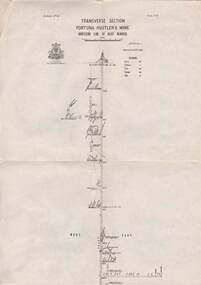
Map - STRUGNELL COLLECTION: HUSTLER'S LINE OF REEFS, BENDIGO, September 1913
Map, Hustler's Line of Reefs, Fortuna Hustler's Mine, Bendigo, Transverse Section. Plate Mo.111(3).Bulletin No 33 Signed H.A.Whitelaw. Drawing shows the vertical shaft descending to over 2228 feet and appears to show samples of connecting horizontal shafts with their respective mineral contentsUnderground Survey Office, Bendigo.map, bendigo, fortuna hustler's mine -
 Bendigo Historical Society Inc.
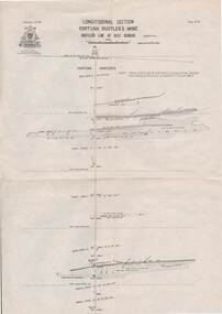
Map - STRUGNELL COLLECTION: HUSTLER'S LINE OF REEF, BENDIGO
Map, Hustler's Line of Reef, Bendigo, Fortuna Hustler's Mine, Longitudinal Section. Plate No. 1V (4). NOTE--- Plates 4,8,13,29,26 & 31 form a Longitudinal Section from Fortuna Hustler's to Hustler's Consols Mine.Bulletin No 33 Signed H.A.Whitelaw. Drawing shows the vertical shaft descending to over 2228 feetUnderground Survey Office, Bendigo.map, bendigo, fortuna hustler's mine -
 Bendigo Historical Society Inc.
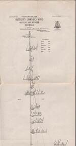
Map - STRUGNELL COLLECTION: HUSTLER'S LINE OF REEFS, September 1913
Map, Hustler's Line of Reefs, Hustler's Consols Mine, Transverse Section, Bendigo.Plate no. XXX111 (33).Bulletin No 33 Signed H.A.Whitelaw. Drawing shows the vertical shaft descending to over 1326 feet and appears to show samples of connecting horizontal shafts with their respective mineral contentsUnderground Survey Office, Bendigo.map, bendigo, hustler's consols mine -
 Bendigo Historical Society Inc.
Map - HUSTLER'S LINE OF REEFS, September 1913
Map, Hustler's Line of Reefs, Hustler's Reef & Hustler's Reef No. ! Mines, Bendigo, Longitudinal Section,Plate No.XX (20). NOTE-- Plates 4,8,13,20,26 & 31 form a Logitudinal Section from Fortuna Hustler's to Hustler's Consols Mine.Bulletin No 33 Signed H.A.Whitelaw. Drawing shows the vertical shaft descending to over 1601 feetUnderground Survey Office, Bendigo,map, bendigo, hustler's reef & hustler's reef 1 -
 Bendigo Historical Society Inc.
Map - STRUGNELL COLLECTION: HUSTLER'S LINE OF REEFS, September 1913
Map, Hustler's Line of Reefs, Hustler's Reef Mine, Transverse Section, Bendigo. Plate No. XV111 (18).Bulletin No 33 Signed, H.A.Whitelaw. Drawing shows the vertical shaft descending to over 2195 feet and appears to show samples of connecting horizontal shafts with their respective mineral contentsUnderground Survey Office, Bendigo.map, bendigo, hustler's reef mine -
 Bendigo Historical Society Inc.
Map - STRUGNELL COLLECTION: HUSTLER'S LINE OF REEF'S. HUSTLER'S REEF NO.1 MINE, September 1913
Map, Hustler's Line of Reefs, Hustler's Reef No. 1, Bendigo, East & West Cross-cuts, North & South of Shaft, Plate No.XX11 (22). Bulletin No 33 Signed H.A.Whitelaw. Drawing shows the vertical shaft descending to over 1229 feet and appears to show samples of connecting horizontal shafts with their respective mineral contentsUnderground Survey Office, Bendigo.map, bendigo, hustler's reef no.1 mine -
 Bendigo Historical Society Inc.
Map - STRUGNELL COLLECTION: HUSTLER'S LINE OF REEFS, September 1913
Map, Hustler's Line of Reefs, Hustler's Reef & Hustler's Reef No.1 Mines Plan.Plate No. XV1.(16) Sheet 2 .Bulletin No 33 Signed H.A.Whitelaw.Underground Survey Office, Bendigo, September,1913. Included is the emblem of the Geological Survey of Victoria. Drawing shows a plan view of reefs and shaft locations .Underground Survey Office, Bendigomap, bendigo, hustler's reef & hustler's reef 1 -
 Bendigo Historical Society Inc.
Map - STRUGNELL COLLECTION: HUSTLER'S LINE OF REEFS, September 1913
Map, Hustler's Line of Reefs, Hustler's Reef No.1 Mine Bendigo, Transverse Section.Plate No. XX1 (21).Bulletin No 33 Signed H.A.Whitelaw. Drawing shows the vertical shaft descending to over 1428 feet and appears to show samples of connecting horizontal shafts with their respective mineral contentsUnderground Survey Office, Bendigo.map, bendigo, hustler's reef no.1 mine -
 Bendigo Historical Society Inc.
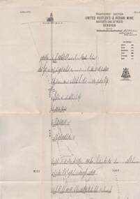
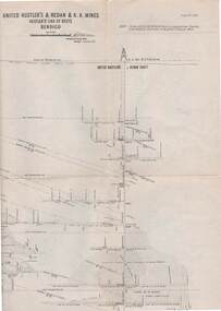
Map - STRUGNELL COLLECTION: UNITED HUSTLER'S & REDAN MINE, September 1913
Map, United Hustler's & Redan Mine, Transverse Section, Hustler's Line of Reefs, Bendigo. Plate No. XX1X (29).Bulletin No 33 Signed H.A.Whitelaw. Drawing shows the vertical shaft descending to over 1805 feet and appears to show samples of connecting horizontal shafts with their respective mineral contents. One level shows respective water levels .Underground Survey Officemap, bendigo, hustler's & redan mine -
 Bendigo Historical Society Inc.
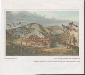
Painting - CAROL HOLSWORTH COLLECTION: 1970 NATIONAL BANK PAINTING 'UPPER SHAFT - PORT LINCOLN MINE 1848'
... 'UPPER SHAFT - PORT LINCOLN MINE 1848'...1970 NATIONAL BANK PAINTING REPRODUCTION Upper Shaft , Port... REPRODUCTION Upper Shaft , Port Lincoln Mine 1848 possibly painted ...1970 NATIONAL BANK PAINTING REPRODUCTION Upper Shaft , Port Lincoln Mine 1848 possibly painted by W.A. Cawthorne 1848 Below the picture title the words - Reproduced by the National Bank in 1970 from the watercolour in the Mitchell Library , Sydney , by permission of the Trustees.The centre of the picture shows mine workings four or five men are shown in the picture the rest of the area is undevelopedpainting, watercolour, gold diggers -
 Bendigo Historical Society Inc.
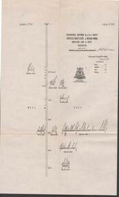
Map - STRUGNELL COLLECTION: UNITED HUSTLER'S & REDAN MINE, September 1913
... Map, Transverse Sections N. & S. Of shaft, United... Bendigo hustler's & redan mine Underground Survey Office, Bendigo ...Map, Transverse Sections N. & S. Of shaft, United Hustler's & Redan Mine, Hustler's Line of Reef, Bendigo. Plate No. XXX (30).Bulletin No 33 Signed H.A.Whitelaw. Drawing shows the vertical shaft descending to over 976 feet and appears to show samples of connecting horizontal shafts with their respective mineral contentsUnderground Survey Office, Bendigo.map, bendigo, hustler's & redan mine -
 Bendigo Historical Society Inc.
Map - STRUGNELL COLLECTION: UNITED HUSTLER'S & REDAN & K.K.MINES, September,1913
Map, United Hustler's & Redan & K.K.Mines, Hustler's Line of Reefs, Bendigo.Plat No.XXX1(31),. NOTE:- Plates 4,8,13,20,26,& 31 form a Longitudinal Section from Fortuna Hustler's to Hystler's Consols Mine. Bulletin 33.Signed H.A.Whitelaw. Drawing shows the vertical shafts descending to over 1932 feet and 1805 feet respectively .Underground Survey Office, Bendigo.map, bendigo, united hustler's, redan, k.k.mines -
 Bendigo Historical Society Inc.
Map - GEOLOGICAL MAP: BENDIGO GOLD FIELDS
GEOLOGICAL MAP - BENDIGO GOLD FIELDS - Donated by JOHN HORWOOD. Two geological maps of the Bendigo Gold fields. The maps display , reef lines, Hills, Dams and mine locations. Also Anticlines, sinclines, shafts, alluvial deposits, contours and gullys. All items are superimposed on a map of the major roads and streets of Bendigo. The maps were printed by The Victorian Minister for Mines in 1923 and re-issued in 1936. The maps have been specifically framed and donated to The Bendigo Historical Society Inc. in May 2015 for display at Specimen Cottage. John had been a student at The School of Mines- Bendigo and found them useful as a student living in Bendigo. Prior to being framed , the maps have been kept rolled up in his home. Accession Number 309/15 Were on Display at Specimen Cottage 2015 - 2020. After all items removed from SC to the BRAC in 2021 the framed maps could not be located. Search ongoing. BP 2.3.2023Victorian Minister of Minesgoldfields -
 Bendigo Historical Society Inc.
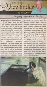
Newspaper - JACK PERRY COLLECTION: NEWSPAPER COLLAPSING SHAFTS IN MINES
... COLLAPSING SHAFTS IN MINES ...Newspaper article re collapsing shafts. Mentions Holdsworth, Eaglehawk Rd. intersection., Darling Street, Long Gully Creek, St. Lawrence Crt. Subsidences. Bendigo Bendigo Weekly 20.9.99person, individual, jack perry -
 Bendigo Historical Society Inc.
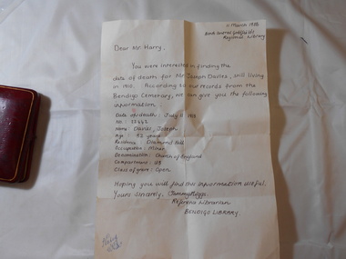
Medal - JOSEPH DAVIES COLLECTION: MEDAL 1909, 1909
Joseph Davies collection, bravery award medal awarded to Joseph Davies for an act of bravery in rescuing a fellow miner from a shaft of the Goldfields Consolidated mine Bendigo after an explosion on July 16th 1909. Circular medal with a blue and gold ribbon & pin clasp, showing 2 miners on one side and the word Courage, bust of Edward VII on other side, name Joseph Davies etched on rim. Encased in a red leather box with satin & velvet lining.trophies & awards, public events, bravery -
 Bendigo Historical Society Inc.
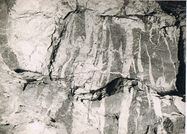
Photograph - MCCOLL, RANKIN AND STANISTREET COLLECTION: MONUMENT HILL MINE
Photograph. Black and white photo- ''Monument Hill Mine No. 688'' Level north and 40' N of shaft section.Detail picture of upper limit of Upper Roof showing development of quartz spurs and stringers and formation of ss inclusions 1'' approx 1'.photograph, landscape, monument hill mine -
 Bendigo Historical Society Inc.
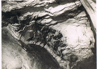
Photograph - MCCOLL, RANKIN AND STANISTREET COLLECTION: MONUMENT HILL MINE 655
Photograph. Black and white photo - Monument Hill Mine 655. Int stope below 640' level 150' south of shaft. Picture looking south at west side of Upper Roof.photograph, landscape, monument hill mine 655