Showing 1328 items
matching mount view
-
 Eltham District Historical Society Inc
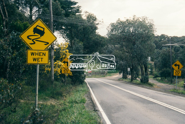
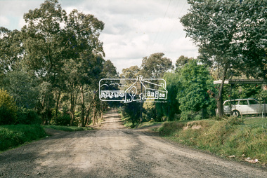
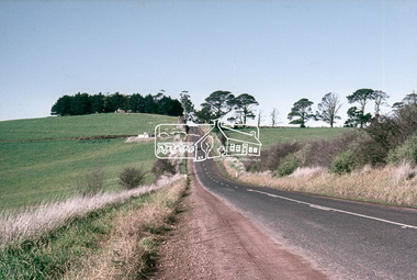
Slide - Photograph, Eltham-Yarra Glen Road, Research, c.Aug. 1990
Part of a presentation, "Roads and Byways of the Shire of Eltham", by Russell Yeoman to the 12 September 1990 Society meeting. Slides shown included copies of old photos and recent images ranging from the suburban streets of Eltham and Montmorency to the mountain roads of Kinglake. In the byways category are views of some iof the Shire's bicycle paths including then recently completed sections of the Main Yarra Trail at Lower Plenty.35mm colour positive transparency (1 of 37) Mount - Agfachrome Agfa CS System black 8 dotsinfrastructure, roads, research (vic.), cassells road, eltham-yarra glen road -
 Eltham District Historical Society Inc
Slide - Photograph, Eltham-Yarra Glen Road, Research, c.Aug. 1990
Part of a presentation, "Roads and Byways of the Shire of Eltham", by Russell Yeoman to the 12 September 1990 Society meeting. Slides shown included copies of old photos and recent images ranging from the suburban streets of Eltham and Montmorency to the mountain roads of Kinglake. In the byways category are views of some iof the Shire's bicycle paths including then recently completed sections of the Main Yarra Trail at Lower Plenty.35mm colour positive transparency (1 of 37) Mount - Agfachrome Agfa CS System black 8 dotsinfrastructure, roads, research (vic.), eltham-yarra glen road -
 Eltham District Historical Society Inc
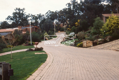
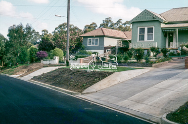
Slide - Photograph, Catherine Court, Eltham, c.Aug. 1990
Part of a presentation, "Roads and Byways of the Shire of Eltham", by Russell Yeoman to the 12 September 1990 Society meeting. Slides shown included copies of old photos and recent images ranging from the suburban streets of Eltham and Montmorency to the mountain roads of Kinglake. In the byways category are views of some iof the Shire's bicycle paths including then recently completed sections of the Main Yarra Trail at Lower Plenty.35mm colour positive transparency (1 of 37) Mount - Agfachrome Agfa CS System black 8 dotsinfrastructure, roads, catherine court, eltham -
 Eltham District Historical Society Inc
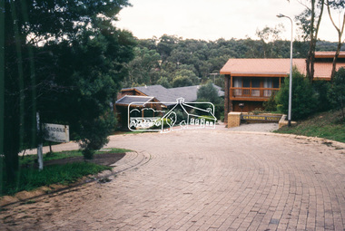
Slide - Photograph, Catherine Court, Eltham, c.Aug. 1990
Part of a presentation, "Roads and Byways of the Shire of Eltham", by Russell Yeoman to the 12 September 1990 Society meeting. Slides shown included copies of old photos and recent images ranging from the suburban streets of Eltham and Montmorency to the mountain roads of Kinglake. In the byways category are views of some iof the Shire's bicycle paths including then recently completed sections of the Main Yarra Trail at Lower Plenty.35mm colour positive transparency (1 of 37) Mount - Agfachrome Agfa CS System black 8 dotsinfrastructure, roads, catherine court, eltham -
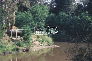
 Eltham District Historical Society Inc
Slide - Photograph, Viewing platform near the confluence of Diamond Creek and Yarra River, c.Nov. 2001
... River 35mm colour positive transparency Mount - Black and White ...Part of a slide show presentation "A Trip Down the Diamond Creek" by Russell Yeoman to the Eltham District Historical Society meeting of 14 Nov. 200135mm colour positive transparency Mount - Black and Whiteconfluence, diamond creek, yarra river -
 Eltham District Historical Society Inc
Slide - Photograph, Viewing platform near the confluence of Diamond Creek and Yarra River, c.Nov. 2001
... river 35mm colour positive transparency Mount - Black and White ...Part of a slide show presentation "A Trip Down the Diamond Creek" by Russell Yeoman to the Eltham District Historical Society meeting of 14 Nov. 200135mm colour positive transparency Mount - Black and Whiteconfluence, diamond creek, yarra river -
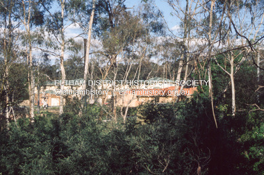 Eltham District Historical Society Inc
Slide - Photograph, Development either side of Railway Road viewed from across Railway Parade, Eltham, c.Nov. 2001
Part of a slide show presentation "A Trip Down the Diamond Creek" by Russell Yeoman to the Eltham District Historical Society meeting of 14 Nov. 200135mm colour positive transparency Mount - Black and Whiteeltham north, housing estate, railway parade, railway road, eltham -
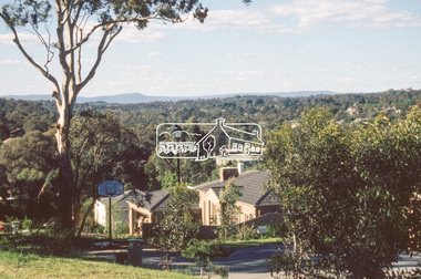 Eltham District Historical Society Inc
Slide - Photograph, Northeast view from near 68 Porter Street, Eltham, c.Nov. 2001
Part of a slide show presentation "A Trip Down the Diamond Creek" by Russell Yeoman to the Eltham District Historical Society meeting of 14 Nov. 200135mm colour positive transparency Mount - Black and Whiteeltham, porter street -
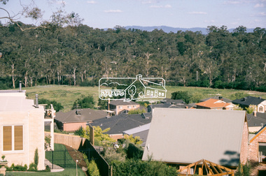 Eltham District Historical Society Inc
Slide - Photograph, Southeast view from near 60 Porter Street, Eltham, c.Nov. 2001
Part of a slide show presentation "A Trip Down the Diamond Creek" by Russell Yeoman to the Eltham District Historical Society meeting of 14 Nov. 200135mm colour positive transparency Mount - Black and Whiteeltham, porter street -
 Eltham District Historical Society Inc
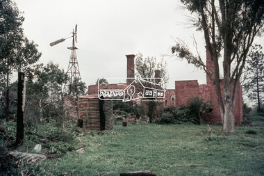
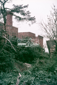
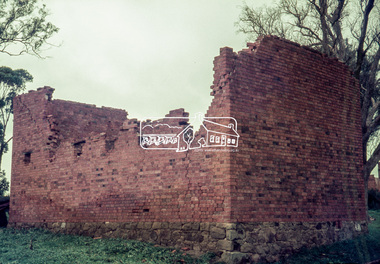
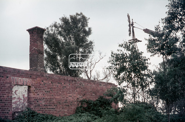
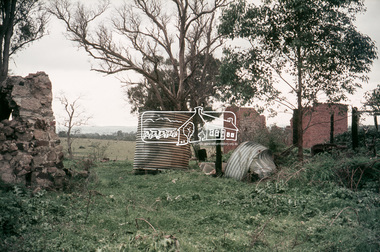
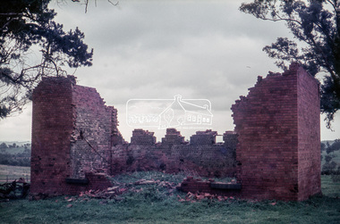
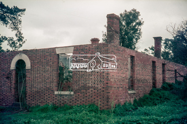
Work on paper (Sub-Item) - Photograph, The Kinglake escarpment. View from Bald Spur lookout across Arthurs Creek to Mount Sugarloaf, 1980
kinglake, blad spur, arthurs creek, mount sugarloaf -
 Eltham District Historical Society Inc
Photograph, Batter treatment, McFarlane Street, Montmorency, 1 July 1972, 1972
View looking at numbers 6 and 8 McFarlane Street35mm colour positive transparency blue Agfacolour Service plastic mounthouses, infrastructure, mcfarlane street, montmorency, streets -
 Eltham District Historical Society Inc
Photograph, Baldwin Avenue from Mountain View Road, Montmorency, c.1972, 1972c
Shire of Eltham road construction and realignment works on Baldwin Avenue, Lilicur Road and Price Avenue, Montmorency, c.197235mm colour positive transparency blue Agfacolour Service plastic mountbaldwin avenue, infrastructure, mountain view road, road construction -
 Eltham District Historical Society Inc
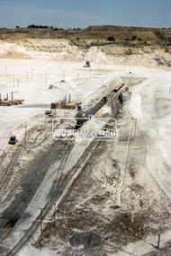
Photograph, Garratt locomotive in the limestone quarry, viewed from top edge, Fyansford Cement Works Railway, November 1962, 1962
Digital TIFF file Scan of 35mm Kodachrome colour positive transparency mounted in cardboard Kodachrome mountProcessing date FEB 64fyansford, fyansford cement works railway, garratt locomotive, george coop collection -
 Eltham District Historical Society Inc
Slide, "Kangaroo Hall" (c.1843-1969), Donaldsons Road, Kangaroo Ground, which was destroyed during the January 8, 1969 bushfire; c.1975, 1975c
Built by James and Isabella Donaldson at the centre of their 1 square mile property southwest of the present day Presbyterian Church. The Donaldsons first arrived in Port Phillip on 17 December 1841. Their first house was a bark hut which was replaced by this substantial brick home around the mid 1840s. James Donladson died 1856. Kangaroo Ground Presbyterian Church http://kgpc.pcvic.org.au/history-2.html Pictures of the farm and homestead (rented by Mr E. Hobson) were published in The Weekly Times, 18 March 1911, p27 1911 'MR. E. HOBSON'S FARM AT KANGAROO GROUND.', Weekly Times (Melbourne, Vic. : 1869 - 1954), 18 March, p. 27. , viewed 29 Feb 2020, http://nla.gov.au/nla.news-article222243528 A letter from Mr Hobson published in the following edition clarified that he only rented the property and that the owner was Mr John Donaldson of Sandringham 1911 'KANGAROO GROUND.', Weekly Times (Melbourne, Vic. : 1869 - 1954), 25 March, p. 47. , viewed 29 Feb 2020, http://nla.gov.au/nla.news-article22224117935 mm colour positive transparency Mount - Agfacolor Service (Blue)bushfire, donaldson home, donaldsons road, isabella donaldson, james donaldson, kangaroo ground, kangaroo hall, victorian bushfires - 1969 -
 Eltham District Historical Society Inc
Slide, View of Martin's house indicating its relationship to the gully, Bonds Road, Lower Plenty, 18 July 1972, 1972
... positive transparency Mount - Agfacolor Service (Blue) View ...Water drainage work undertaken by Eltham Shire Council in Bonds Road, Lower Plenty outside the Martin property opposite Montpelier Drive, July 1972 35 mm colour positive transparency Mount - Agfacolor Service (Blue)Bonds Road (Martin property) 12.10 pm 18.7.72bonds road, drainage works, eltham shire council, infrastructure, lower plenty, martin property, montpelier drive -
 Eltham District Historical Society Inc
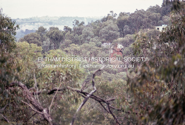
Slide, Shire of Eltham War Memorial Tower, Eltham-Yarra Glen Road, Kangaroo Ground, 24 Jul 1973
Looking east towards the tower across the western title of land purchased by Council 16 Feb. 1973 upon which the Moor-rul viewing platform and grasslands now stand.35 mm colour positive transparency Mount - Agfacolor Service (Blue)eltham-yarra glen road, kangaroo ground, shire of eltham war memorial, war memorial tower -
 Eltham District Historical Society Inc
Photograph, Michael Wood, Houses on Progress Road viewed from Glen Park Road, Eltham North, February 1970, 1970
Wood family home (1969-2011) pre and post construction by Knox and Hellemons Shows Wood family home on Progress Road in centre of field of viewKodachrome 35mm colour transparency in cardboard mount Processing date FEB70M6Inscribed in ink "Hoses on Progress Rd from Glen Park Rd, Eltham North 1970"alistair knox design, eltham north, hellemon, houses, progress road, glen park road -
 Eltham District Historical Society Inc
Photograph, Michael Wood, View south from 184 Progress Road to houses on Scenic Crescent, Eltham North, February 1970, 1970
... , houses, progress road, Scenic Crescent Inscribed in ink "View ...Wood family home (1969-2011) pre and post construction by Knox and HellemonsKodachrome 35mm colour transparency in cardboard mount Processing date FEB70M6Inscribed in ink "View south from 184 Progress to Scenic Crescent, Eltham North 1970"alistair knox design, eltham north, hellemon, houses, progress road, scenic crescent -
 Eltham District Historical Society Inc
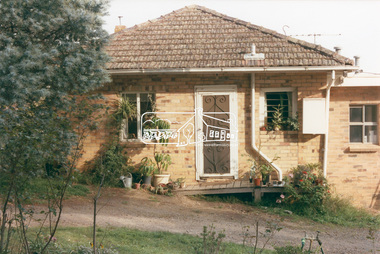
Photograph, 218 Pitt Street, Eltham, c.1985, 1985c
House was rented by Kim Tarpey between October 1983 and June 1985. It was one of the buildings originally part of Birds Orchard. Harold Bird was her landlord, a retired primary school teacher who, when she knew him was driving the mobile library bus. Her partner had him as a teacher at Montmorency Primary in grade 4. The house was next door to what is now a bushland reserve near the Pauline Toner Reserve. It was on the corner of Pitt and Arthur St - the driveway was near the roundabout and went off to the right of the driveway that now belongings to 220 Pitt street and which was bushland at the time. It was sold in 1985 and consequently demolished, a large house has replaced it. It was situated approximately where the front door of No. 218 is nowadays with the facade roughly in line with the now garage wall to the left of this front door.Digital file only - scanned from personal photo album on loan (27 images) List of images EDHS_04644-1.tif Kitchen window looking towards Eucalyptus Road, 218 Pitt Street, Eltham, c.1985 EDHS_04644-2.tif 218 Pitt Street, Eltham, c.1985 EDHS_04644-3.tif 218 Pitt Street, Eltham, c.1985 EDHS_04644-4.tif Kitchen looking towards Pitt Street Reserve, 218 Pitt Street, Eltham, c.1985 EDHS_04644-5.tif 218 Pitt Street, Eltham, c.1985 EDHS_04644-6.tif Bathroom walkway/laundry, 218 Pitt Street, Eltham, c.1985 EDHS_04644-7.tif 218 Pitt Street, Eltham, c.1985 EDHS_04644-8.tif 218 Pitt Street, Eltham, c.1985 EDHS_04644-9.tif 218 Pitt Street, Eltham, c.1985 EDHS_04644-10.tif 218 Pitt Street, Eltham, c.1985 EDHS_04644-11.tif 218 Pitt Street, Eltham, c.1985 EDHS_04644-12.tif 218 Pitt Street, Eltham, c.1985 EDHS_04644-13.tif 218 Pitt Street, Eltham, c.1985 EDHS_04644-14.tif 218 Pitt Street, Eltham, c.1985 EDHS_04644-15.tif 218 Pitt Street, Eltham, c.1985 EDHS_04644-16.tif 218 Pitt Street, Eltham, c.1985 EDHS_04644-17.tif Lounge window looking towards Mount Pleasant Road, 218 Pitt Street, Eltham, c.1985 EDHS_04644-18.tif Fire place in lounge, 218 Pitt Street, Eltham, c.1985 EDHS_04644-19.tif Fire place in lounge, 218 Pitt Street, Eltham, c.1985 EDHS_04644-20.tif View from lounge room window looking towards corner of Eucalyptus and Mount Pleasant roads, 218 Pitt Street, Eltham, c.1985 EDHS_04644-21.tif View from lounge room window looking towards corner of Eucalyptus and Mount Pleasant roads, 218 Pitt Street, Eltham, c.1985 EDHS_04644-22.tif View from lounge room looking towards Pitt Street and Wattle Grove, 218 Pitt Street, Eltham, c.1985 EDHS_04644-23.tif View from lounge room looking towards Pitt Street and Wattle Grove, 218 Pitt Street, Eltham, c.1985 EDHS_04644-24.tif 218 Pitt Street, Eltham, c.1985 EDHS_04644-25.tif Back garden showing previous tank stumps. There was a hole in the wall where a possum got through, 218 Pitt Street, Eltham, c.1985 EDHS_04644-26.tif View from back fence looking towards Pitt Street and Wattle Grove, 218 Pitt Street, Eltham, c.1985 EDHS_04644-27.tif View from back fence on to Eucalyptus Road. Pitt Street Reserve to the right, 18 Pitt Street, Eltham, c.1985218 pitt street, eltham, houses, birds orchard, harold bird, kim tarpey, eucalyptus road -
 Eltham District Historical Society Inc
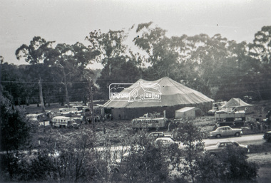
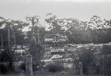
Slide - Photograph, Grace Mitchell, Ashtons Circus set up in Bremner's Reserve, Main Road, Eltham, c.1955
View from Grace Mitchell's shop at the corner of Mount Pleasant Road and Main Road. Grace Mitchell was probably best known for her Eltham shop at the corner of Mt Pleasant Road and Main Road. Grace's memories covered many local identities who were patrons of her shop between 1954 and 1971. From the elevated position of her shop and home Grace was able to view a varied passing parade of Eltham events from ERSILAC, Easter and Eltham Festival parades passing on their way to Eltham Lower Park, circuses in Wingrove Park (then Bremner’s Reserve), roadworks and other happenings. Bremner's Reserve was renamed Wingrove Park c.1970 This photo was from a series of images presented by Grace Mitchell at a Society talk 10 March 1993 on the theme of “My Eltham”.35mm Kodak 5052 TMX Black and White transparency, 1 strip, 6 frames Black and white print 17 x 25.4 cmashtons circus, bremner's flat, circus, grace mitchell, main road, mount pleasant road, wingrove park -
 Eltham District Historical Society Inc
Slide - Photograph, Grace Mitchell, Ashtons Circus set up in Bremner's Reserve, Main Road, Eltham, c.1955
View from Grace Mitchell's shop at the corner of Mount Pleasant Road and Main Road. Grace Mitchell was probably best known for her Eltham shop at the corner of Mt Pleasant Road and Main Road. Grace's memories covered many local identities who were patrons of her shop between 1954 and 1971. From the elevated position of her shop and home Grace was able to view a varied passing parade of Eltham events from ERSILAC, Easter and Eltham Festival parades passing on their way to Eltham Lower Park, circuses in Wingrove Park (then Bremner’s Reserve), roadworks and other happenings. Bremner's Reserve was renamed Wingrove Park c.1970 This photo was from a series of images presented by Grace Mitchell at a Society talk 10 March 1993 on the theme of “My Eltham”.35mm Kodak 5052 TMX Black and White transparency, 1 strip, 6 frames Black and white print 17 x 25.4 cmashtons circus, bremner's flat, circus, grace mitchell, main road, mount pleasant road, wingrove park