Showing 1005 items
matching navigational
-
 Wangaratta RSL Sub Branch
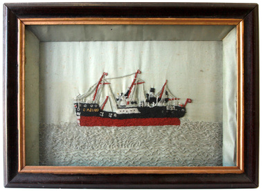
Booklet, The Takadaussie, August 1919
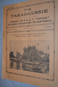
The Takadaussie - Journal of H.M.A.T "Takada" voyaging Devonpart to Australia - Souvenir Copy August 1919 Colombo Built in 1914 by the British India Steam Navigation Company originally for the Indian-chinese trade. The Takada was used as a hospital ship making numerous trips with sick and wounded soldiers. On the signing of the Armistice she made three trips carrying repatriated prisoners of war before transporting Australian troops home.Beige and black booklet with photograph of three primitive barges surrounded by ornate borderhmat takada, the takadaussie, troopship, ww1 -
 Queenscliffe Maritime Museum
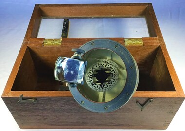
Equipment - Compass correctors, shadow pins and magnets
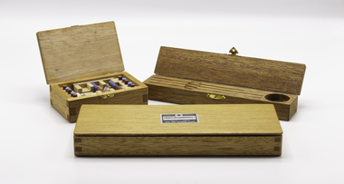
True North is at the centre of the north pole This is a fixed point at the top of the planet. The majority of our navigational charts are orientated so that they use true north as their reference point. This is because true north doesn’t move. Magnets don’t point towards true north however. They point toward magnetic north which is in a different geographical place. The difference in the angle between true north and magnetic north is call variation.Three wooden boxes containing magnetic compass quadrantal correctors, correcting magnets and shadow pins.Saura Keiki Seisakusho Co Ltdcompass, correcting magnets, magnetic variation -
 Bendigo Military Museum
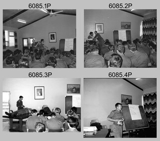
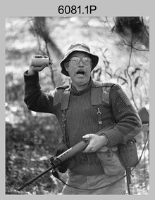
Photograph - Army Survey Regiment - Regimental Training, 1986
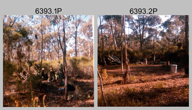
This is a set of 32 photographs of the Army Survey Regiment personnel undertaking military skills revision at Fortuna Villa, Bendigo (photos .29P to .32P) and most likely the Wellsford Forest in 1986. It is evident in the photo set they participated in lessons on the handling of the M30 Grenade and SLR Rifle at Fortuna before the field exercise. Other military skills such as first aid, navigation minor infantry tactics were probably included in the training.This is a set of 32 photographs of the Army Survey Regiment undertaking Regimental Training at Wellsford Forest and Fortuna Villa in 1986. The photographs were printed on photographic paper and are part of the Army Survey Regiment’s Collection. The photographs were scanned at 300 dpi. .1) - Photo, colour, 1986. Unidentified soldiers preparing their meal. .2) - Photo, colour, 1986. Hootchie accommodation. .3) - Photo, colour, 1986. Hootchie accommodation L to R: CPL Roger Pearson and unidentified soldier. .4) & .5) - Photo, colour, 1986. Unidentified personnel enjoying bush cricket. .6) - Photo, colour, 1986. Unidentified soldier with SLR rifle. .7) - Photo, colour, 1986. Unidentified soldiers enjoying a tea break. .8) - Photo, colour, 1986. Unidentified soldier on the shovel. .9) - Photo, colour, 1986. Unidentified soldiers preparing their meal. .10) - Photo, colour, 1986. Hootchie accommodation. .11) & .12) - Photo, colour, 1986. Unidentified soldiers undertaking training. .13) - Photo, colour, 1986. Hootchie accommodation, unidentified soldiers. .14) - Photo, colour, 1986. Unidentified soldier struggles to set-up their stretcher. .15) - Photo, colour, 1986, Unidentified soldier struggles to set-up their hootchie. .16) - Photo, colour, 1986. Unidentified soldiers undertaking training. .17) - Photo, colour, 1986. Hootchie accommodation. .18) - Photo, colour, 1986. SPR Dave Lawler takes a break. .19) & .20) - Photo, colour. 1986. Unidentified soldier tickles an echidna’s tummy. .21)- Photo, colour, 1986. Ablutions set-up. .22) & .23) - Photo, colour, 1986. Unidentified soldier’s hootchie accommodation. .24) - Photo, colour, 1986. Unidentified soldiers undertaking training. .25) to .28) - Photo, colour, 1986. Unidentified soldiers undertaking grenade training. .29) - Photo, colour, 1986. Unidentified soldiers taking a break from training at Fortuna. .30) to .32) - Photo, colour, 1986. Unidentified soldiers undertaking training at Fortuna..1P to .32P No personnel are identified. Some photographs are annotated ‘Regt Training 1986’royal australian survey corps, rasvy, army survey regiment, army svy regt, fortuna, asr -
 Moorabbin Air Museum
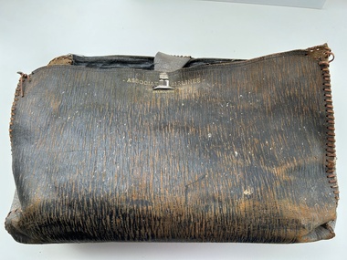
Accessory (Item) - Leather Satchel Marked With Associated Airlines - Melbourne
-
 National Communication Museum
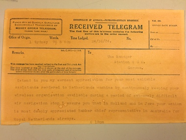
Document - Telegram, 24/10/1934
This telegram was sent from the Royal Netherlands Airways, Sydney, to the manager of ABC Radio Station 2CO, Corowa, New South Wales. This telegram relates to the 1934 London to Melbourne Air Race. The telegram records the Royal Netherlands Airways' thanks to ABC Radio 2CO radio staff for their efforts in broadcasting an emergency message to the residents of Albury after the Dutch airliner ‘Uiver’ became lost at night in bad weather. As requested local radio listeners drove their cars to the Albury racecourse and illuminated an emergency landing ground using their vehicle headlights. This allowed the lost airliner to land safely.This item relates to the London to Melbourne Air Race of 1934, a significant event that shaped Australia's history as it proved travelling to and from Australia could be done within a reasonable time by air, thereby making the country less isolated. Up to that time Australia was three weeks away from Europe by steam ship. The Air Race was dreamt up by the Lord Mayor of Melbourne, Harold Smith, to commemorate the centenary of Victoria's statehood and was sponsored by the Melbourne chocolate manufacturer Sir MacPherson Robertson. The Royal Netherlands Airways entered a Douglas DC2 plane 'Uiver' - the largest aircraft in the race, and the only one to carry passengers as well as crew, to show that a commercial passenger service to Australia was possible. But in the last leg of the race, the Uiver lost its way in an electrical storm over the Riverina town of Albury. Several communication methods were used to land the plane safely, including the signalling of the word "Albury" in Morse code using the town's street lights. Local ABC Radio station 2CO also made a call for locals to light up a makeshift landing strip for the plane at the town's racecourse. The plane landed safely and the next morning with the help of the townspeople who pulled it out of the mud, took off and finished the race in second place. The story of the Uiver points to the importance of communication in its various forms: two-way and broadcast radio, Morse, and light signals. The survival of the Uiver is a reflection of the ingenuity of Australian communications and the solutions that can be found through the sharing of ideas of information. The landing of the Uiver was an important moment in Albury's social history, as residents participated in the rescue of the plane and its passengers, helping the Uiver to continue on its journey and finish second in the Race. When the Uiver crashed in the Syrian Desert in December 1934, Albury residents contributed to a memorial which honoured those who were killed. Beige paper telegram printed with black ink and overwritten with typewriter. Telegram split into sections designating details of the telegram, details of the recipient and a space for the transmitted message. A small section of paper is missing from bottom left corner."Extend to you my warmest appreciation for your most valuable / assistance rendered to Netherlands machine by continuously keeping your / wireless organisation available during a period of extremely difficult / air navigation stop I assure you that in Holland and in Java your action / is most deeply appreciated Bakker chief representative in Australia for / Royal Netherlands airways. / 6 18pm"telegrams, telegraphic messages, communications, radio, uiver, royal netherlands airways, albury, london to melbourne air race, morse code -
 Bendigo Military Museum
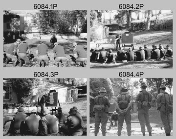
Photograph - Lithographic Squadron Regimental Training, Army Survey Regiment, Bendigo, 1989
This is a set of 24 photographs of Army Survey Regiment’s Lithographic Squadron personnel undertaking regimental training in an unknown location in April 1989. The purpose of the training was probably to provide personnel a practical knowledge of navigation and map reading, RATEL and Survival in the Field, vehicle camouflage, teamwork and leadership. The training did not include infantry and minor tactics due to the absence of weapons. Although these photos are not annotated other than the month and year, most personnel are positively identified.This is a set of 24 photographs of personnel from Lithographic Squadron, Army Survey Regiment, Fortuna, Bendigo, undergoing regimental training in April 1989. The photographs were on 35mm negative film and scanned at 96 dpi. They are part of the Army Survey Regiment’s Collection. .1) - Photo, black & white, 1989, background L to R: Frank Lenane, Bill Jones, foreground L to R: Gavin McLean, Colin Yeats, Peter Dillon. .2) - Photo, black & white, 1989, Rhys De Laine. .3) - Photo, black & white, 1989, L to R: Peter Breukel, Colin Yeats. .4) - Photo, black & white, 1989, L to R: Colin Yeats., Peter Dillon. .5) - Photo, black & white, 1989, L to R: Graeme Spong, Gavin McLean, unidentified (x2), Peter Breukel, Steve Burke, Bill Jones, Colin Yeats. .6) - Photo, black & white, 1989, L to R: Graeme Spong, Bill Jones, Colin Yeats, Peter Dillon, Peter Breukel, Steve Burke, Colin Yeats. .7) - Photo, black & white, 1989, L to R: Graeme Spong, Bill Jones, Colin Yeats, Peter Dillon, .8) - Photo, black & white, 1989, Colin Yeats. .9) - Photo, black & white, 1989, L to R: Gavin McLean, Colin Yeats. .10) - Photo, black & white, 1989, L to R: Steve Burke, Peter Breukel, Colin Yeats, unidentified. .11) - Photo, black & white, 1989, L to R: Steve Burke, Peter Breukel. .12) - Photo, black & white, 1989, L to R: Peter Breukel, Steve Burke. .13) - Photo, black & white, 1989, Craig Hersant. .14) - Photo, black & white, 1989, L to R: Rob Bogumil, Darren Maher, Paul Baker, Rob Jones, Shona Hastie, unidentified, Chad Hardwick. .15) - Photo, black & white, 1989, L to R: Chad Hardwick, unidentified, Rob Bogumil, Rob Jones, Darren Maher, unidentified, Paul Baker. .16) - Photo, black & white, 1989, L to R: Rob Bogumil, Darren Maher, Chad Hardwick, Rob Jones, unidentified (x2), Paul Baker. .17) to .22) - Photo, black & white, 1989, unidentified personnel applying camouflage to truck. Shona Hastie in truck, .23) - Photo, black & white, 1989, L to R: LT Dave Weston, LT Craig Hersant, Trevor Osborne, Bill Jones. .24) - Photo, black & white, 1989, L to R: Andrew Arman, unidentified, Peter Dillon, Steve Burke, Colin Yeats, Peter Breukel. No personnel are identified. Annotation dated April 1989.royal australian survey corps, rasvy, army survey regiment, army svy regt, fortuna, asr, litho -
 Mission to Seafarers Victoria
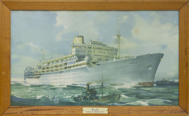
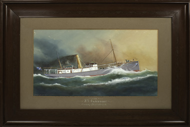
Print - Reproduction, Johnston, P&O 'Iberia' - 29,600 Tons, c.1960
SS Iberia was an ocean liner completed in 1954 for the Peninsular and Oriental Steam Navigation Company (P&O). Along withother liners, Iberia mainly provided passenger service between the United Kingdom and Australia. In the Annual Report 1954, Padre Oliver mentions: " Two fine new P & O ships made their maiden voyages during the year: "Arcadia" and "Iberia". In each case I was privileged to help to represent the Mission at the official luncheon."Marine artColour printed reproduction of a painting or lithograph print featuring 20th C passenger liner, hull and superstructure primarily painted white, under steam at sea. Small tug/fishing vessel in foreground. Larger steam ship on horizon. Print on plain board backing with plain mitred timber frame. Eyelet screws with wire.Printed signature lower right. 'JOHNSTON'iberia, passenger ship, p&o, marine painting, passenger ships, artwork-paintings, peninsular and oriental steam navigation company -
 Warrnambool and District Historical Society Inc.
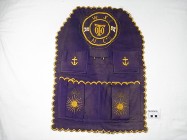
Textile - Work Apron, 1883-1899
The personal 'carry-all', a cloth apron like article was utilised by Thomas Hamilton Osborne in his work with the Warrnambool Steamship Navigation Company. He was Company manager in 1883 until its dissolution in 1899. Osborne wrote many articles on early Warrnambool, particularly maritime material under the name of " Sliding Gunter". When he died he was buried at sea off the breakwater.His sister Mrs Annabella Kell is thought to have made this article.This is a significant item as T.H.Osborne was a key figure in 19th Century Warrnambool history, particularly in maritime affairs. Six sided, scalloped edges, four pockets, two metal hooks, purple woven fabric with yellow and gold embroidery, lifebuoy outline with W.S.N.Co and THO initials embroidered and two flags. Machine sewing of pockets and tab to base apron.W.S.N.Co THO initials on top of each other Two metal hookswork apron, warrnambool steamship navigation company, wsnc, thomas hamilton tracey osborne, annabella kell, sliding gunter -
 Warrnambool and District Historical Society Inc.
Textile - Casino embroidery, S.S. Casino
The SS Casino was a coastal trader of 450 tons gross, 160.4 feet in length, built at Dundee for the Newcastle and Hunter Steam Navigation Company. It had saloon accommodation for 35 people, fore-cabin 25 and carried 300 tons (425 tonnes) of cargo.The Casino called at Warrnambool on 30th May 1882 while on her delivery voyage and narrowly escaped being dragged ashore by gale force winds. While the ship was in Warrnambool the directors of the Belfast and Koroit Steam Navigation Company bought the ship. It was used as a coastal steamer solely on the west coast of Victoria run from 1882. On the morning of 10th July 1932 an attempt was made to berth the ship at Apollo Bay in heavy seas. Captain Middleton decided to take the ship out into the bay and wait until the seas abated, not realising that the anchor used to steady the ship as she was being manoeuvred had pierced her hull. The ship was put about and headed to the beach, but sank. The captain and four crew members were swept off the deck, and though one crew member was rescued, four drowned. The beaded picture was made by Mary Wickham, the grandmother of the donor. This item has significance linking a piece of handcraft and a local ship from the late 19th century.It has significant artistic value. Hand worked embroidery of black, white, maroon, gold & clear glass beads on a background of white polished cotton. The embroidery is in a black painted wooden frame. It is backed by a sheet of "War Cry" 26th April 1896. "Casino" in gold beading on bow of ship.the casino ship, warrnambool casino, warrnambool shipwrecks -
 Flagstaff Hill Maritime Museum and Village
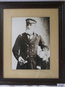
Photograph - Captain F Chapman SS Dawn
The Dawn steamship was a 522-ton coastal trader built in 1876 and it’s original captain Jones operated the vessel around the Victorian west coast from 1877 until 1898 for the Portland & Belfast Steam Navigation Co, the vessel was then owned in October 1885 by the renamed company, Belfast & Koroit Steam Navigation Co., until March 1896 when it’s ownership moved to W Howard Smith & Sons Ltd., This Melbourne company used the ship to service most ports around Australia. Captain F Chapman took over from captain Jones and served on the SS Dawn from 1898 until 1900 when he took command of the SS Casino operated by the Belfast & Koroit Shipping Company at Port Fairy and became the captain from 1900 until 1922 when he retired after twenty-two years becoming the ships longest-serving captain. Captain Roberts took over command until 1924 followed by captain Middleton until 1932 when the Casino was sunk off Apollo Bay and captain Middleton collapsed and died in the surf. Picture of a long serving sea captain connected with a significant ship that was involved in a significant historical incident prior to his taking command of the vessel also his long time association with Port Fairy's Belfast Steam Navigation Company until 1922.Photograph of Captain Chapman framedCaptain F Chapman SS Dawnflagstaff hill, warrnambool, shipwrecked-coast, flagstaff-hill, flagstaff-hill-maritime-museum, maritime-museum, shipwreck-coast, flagstaff-hill-maritime-village, photograph, captain chapman, ss dawn -
 Flagstaff Hill Maritime Museum and Village
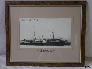
Photograph - SS Dawn
The SS Dawn steamship was a 522-ton coastal trader built in 1876 and it’s original captain Jones operated the vessel around the Victorian west coast from 1877 until 1898 for the Portland & Belfast Steam Navigation Co, the vessel was then owned in October 1885 by the renamed company, Belfast & Koroit Steam Navigation Co., until March 1896 when it’s ownership moved to W Howard Smith & Sons Ltd., This Melbourne company used the ship to service most ports around Australia. Captain F Chapman took over from captain Jones and served on the SS Dawn from 1898 until 1900 when he took command of the SS Casino operated by the Belfast & Koroit Shipping Company at Port Fairy and became the captain from 1900 until 1922 when he retired after twenty-two years becoming the ships longest-serving captain. Captain Roberts took over command until 1924 followed by captain Middleton until 1932 when the Casino was sunk off Apollo Bay and captain Middleton collapsed and died in the surf. Photograph of SS Dawn at Portland. Building in background Portland and Belfast Steamship CompanySS Dawnflagstaff hill, warrnambool, shipwrecked-coast, flagstaff-hill, flagstaff-hill-maritime-museum, maritime-museum, shipwreck-coast, flagstaff-hill-maritime-village -
 Flagstaff Hill Maritime Museum and Village
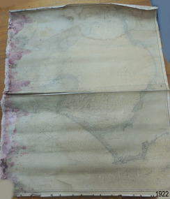
Document - Chart, Admiralty Office, Port Phillip, 1899
Accurate charts were imperative for sea farers to sail their vessels safely from one side of the world to another. The British Admiralty published many charts and updated them frequently. Specialists were employed to gather information such as depth soundings to give the navigator as many helps as possible. At regular intervals the charts had to be updated with the amount of adjustment needed to a compass to allow for magnetic variation.This chart is significant for its association with incoming and outgoin ships for trade and passengers in the late 19th century.Admiralty Chart of Port Phillip, Victoria, South Coast of Australia. It shows navigation buoys, lighthouses, tides and money other details. It was surveyed by Commander Henry L. Cox R.N. in 1864. Published by Admiralty August 19th 1865. Corrections were made by Staff Commander E.J. Stanley R.N. in 1874. The West Channel was surveyed b J.B. Mason , Engineer, in 1899. Published and cartographed in Admiralty, London, England in 1897, supervised by Capt G H Richards R N Hydrographer. Chart was updated in 1899. Sold by W D Potter Agent for Admiralty Charts 145 minorities.Printed: "Port Phillip" "Australia - South Coast, Victoria"flagstaff hill, warrnambool, maritime-museum, flagstaff hill maritime museum & village, shipwreck coast, chart, australia, south coast, port phillip, admiralty, 1899, navigation, cartography, cartographer -
 Warrnambool and District Historical Society Inc.
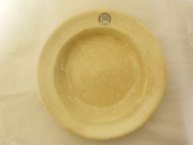
Plate (Belfast & Koroit S.N. Co.), Late 1920s
This plate was made by the Calyx Porcelain and Paint Company which was based in Western Australia and made china for commercial establishments from the 1920s to the 1990s when the company was then known as Australian Fine China. The plate was used by the Belfast and Koroit Steam Navigation Company based in Port Fairy. It was founded in 1882 and operated two ships, the Casino and the Bellinger, servicing the Western Ports between Melbourne and Portland. The Casino was wrecked at Apollo Bay in 1932. Later the company operated the ship, Dawn and survived as a shipping company until the late 1930s.This plate is of interest because it was used by the Belfast and Koroit Steam Navigation Company in the 1920s and 30s. This company was important in the maritime history of Warrnambool, especially in the transportation of potatoes from the Warrnambool region. The Casino, the most important ship operated by the Belfast and Koroit Steam Navigation Company, was also important as a passenger and cargo ship prominent in Warrnambool’s maritime historyThis is a circular-shaped cream soup bowl or dinner plate. On the edge of the plate there is a blue embedded stamp in the shape of a circle with the flag of the steamship company inside. On the base of the plate is the maker’s information in green print. The base of the plate is much crazed and discoloured‘Belfast & Koroit S.N. Co. Ltd.’ ‘Made in Australia, Calyx, W.A.’ belfast & koroit steam navigation company, history of warrnambool -
 Orbost & District Historical Society
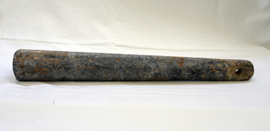
sounding lead, before 1871
This plummet came from S.S. Auckland which was wrecked at Beware Reef near Cape Conran in 1871. The S.S. Aukland was a two masted , iron screw steamer built by C. Mitchell & Co. in 1863 in Newcastle, England. It was owned by the Australasian Steam Navigation Company who modified it in Sydney. In May 1871, on a voyage from Melbourne to Sydney, it ran into breakers and struck Beware Reef. Conditions were foggy and there was a strong easterly current. All passengers and crew were rescued by the S.S. Macedon. (ref. Victorian Heritage Database)The S.S. Aucckland is archaelogically significant. Beware Reef Marine Sanctuary is located five kilometres south east of Cape Conran. On one side of the reef lie the remains of old shipwrecks, including the SS Auckland, a steamship wrecked on the reef in 1871.A tapered conical shaped piece of a lead, a plummet, used for measuring the depth of water.s.s.aukland beware-reef sounding-lead shipwreck -
 Port Fairy Historical Society Museum and Archives
Decorative object - Painting, F. I. Endeavour
For many years this painting hung in the offices of the Belfast & Koroit Steam Navigation Company in Port Fairy. It was painted by Arthur Victor Gregory (1867-1957), a water colourist and marine artist. It depicts the Fisheries Investigation Ship Endeavour, a trawler built to the specifications of the Commonwealth Government in 1909 to assist in identifying new fishing grounds in the seas around Australia. The Endeavour was lost in December 1914 between Macquarie Island and Hobart with the loss of all twenty-one men on board, including Harald Dannevig, the Commonwealth Director of Fisheries.A Painting of a forgotten ship and crew that were forerunners of investigating the reserves of fish in our oceans.A painting of the F. I. Endeavour in a wooden frame. Scroll work on frame.Front - The F. I. Endeavour crossing Bass's Straits A. V. Gregory 10 Reverse - Regal Patronage ?.8.1854 Arthur V. Gregory Marine ? Arthur V. Gregoryship, fishing, scientific, belfast & koroit steam navigation company, endeavour, macquarie island, hobart, harald dannevig -
 Vision Australia
Functional object - Object, Walking stick belonging to Tom Marks
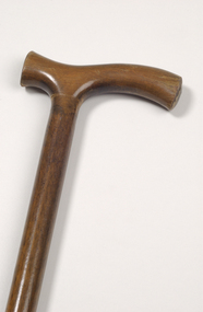
Wooden walking cane believed to have been owned and used by Tom Marks, one of the founding members for the Association for the Advancement of the Blind. He became President in 1900 and served again in the post from 1935 to 1937. Mr Marks's ability to network provided the Association with funds and advice for many years, and he was also fulfilled the position of Secretary for 23 years (1904-1927). This polished wooden walking stick is an example of how canes were not always painted white and could be utilised as both a navigational and support device.Wooden walking stick with black rubber tiptom marks, assistive devices, white cane -
 Nhill Aviation Heritage Centre
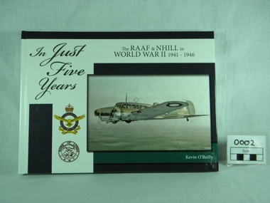
Book, K. O'Reilly, In Just Five Years - 1941 to 1946, Published 2009
Hardback,history of the RAAF & Nhill in World War II 1941 - 1946, written by Kevin O'Reilly. Front coloured white & blue, photo of Avro Anson Mk1 on front, with emblems of RAAF and Shire of Lowan. Reverse in simlilar colours, with cartoons and 8 small photos. Preface by Chris G Spence AO, Air Vice Marshal (Retd).history world war ii, raaf base nhill, 1941 1946, kevin o reilly, john clarkson, peter isaccson wing commander retd am dfc afc dfm, chris, spence, air vice marshal retd -
 Queenscliffe Maritime Museum
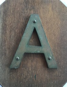
Sign - Metal letter A
The steamship, SS Australia, was built in Greenock, Scotland in 1892, for the P & O Steam Navigation Company. Australia was considered to be one of the most luxurious vessels afloat and she held the speed record from England to Australia at the time. On 21st June 1904, due to pilot error, the Australia hit the notorious Corsair Rock, part of the Point Nepean Reef, on the eastern side of Port Philip heads, opening a gaping 5 meter hole along her keel. Passengers and some of the crew were rescued by craft sent from Queenscliff.Relic from a significant wreck on Corsair Rock at Point NepeanMetal letter A mounted on timber board in front with salvage account on the backAccount of salvage of artefactsign, ships name, ss australia -
 Kew Historical Society Inc
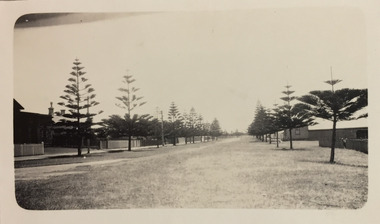
Photograph - Gipps Street, Port Fairy, c.1926
Henry Beater Christian (1886-1962) , was a descendant of one of the earliest settler families in Kew. Employed at the Kew Asylum as a 'public servant', he was a skilled amateur photographer, photographing numerous scenes in Kew and on his travels around Victoria. The majority of his photographs date from 1916 to 1929. His finest photographs are housed in two photograph albums. Digital copy of a photograph from page 23 of the 47-page photograph album containing 261 gelatinous silver images, loaned by Diane Washfold with permission given to digitise and hold a copy in our collection. In the 1920s, the photographer travelled throughout Victoria, including on the west coast from Port Campbell to Port Fairy. Trips were presumably made by train and by foot. Lynda Tieman and her team at the Port Fairy Historical Society have tentatively identified a number of Henry Christian's photographs of Port Fairy, of which this is one. The street pictured is Gipps Street, At the left is the Court House while the Belfast and Koroit Steam Navigation Company offices are on the righthenry beater christian (1886-1962), landscape photography, christian-washfold collection, photograph albums, port fairy (vic.), belfast and koroit steam navigation company, gipps street, court house -- port fairy (vic.) -
 Wodonga & District Historical Society Inc
Album - Hume Reservoir Australia Album - Dimensions of Hume Reservoir, Department of Public Works, N.S.W, 1927
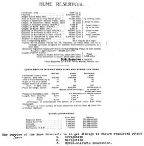
This set of photos is from a leather bound album bearing the inscription "HUME RESERVOIR AUSTRALIA" plus 'The Rt. Hon. L. C. M. S. Amery, P. C., M .P.' all inscribed in gold. It was presented to The Rt. Hon. L. C. M. S. Amery, P. C., M. P, Secretary of State for Dominion Affairs on the occasion of his visit to the Hume Reservoir on 2nd November 1927. This album is of local and national significance as it documents the planning and development of the Hume Reservoir up to 1927. It was the largest water reservoir in the British Empire. The album records the pioneering engineering work that went into its construction.Table outlining the Dimensions of the Hume Weir and comparisons with MAKWAR and BURRINJUCK DAMS, and some other comparisons. MAKWAR Dam is located on the Blue Nile about five miles south of Sennar and 175 miles south of Khartoum in Sudan. The construction of this dam started in 1922 and was completed in May 1925, while the British Empire colonised Sudan. It was officially opened on 21st January 1926. The BURRINJUCK DAM is situated in the upper catchment of the Murrumbidgee River, approximately 60 kms from Yass, N.S.W. It was built from 1907 to 1927 The stated purpose of the Hume Reservoir is to get storage to ensure regulated output for:- 1. Irrigation 2. Navigation 3. Hydro-electric Generation.hume reservoir australia, river murray waters scheme, hume dimensions -
 Bendigo Military Museum
Photograph - Army Survey Regiment - Regimental Training First Aid, 1985
This is a set of 14 photographs of Army Survey Regiment personnel undertaking the First Aid phase of regimental training held at Fortuna, Bendigo c1985. This was one of six objectives outlined in the administrative instruction – Exercise “City Soldier” accompanying these photos. The other objectives were weapons skills revision for SLR Rifle and M30 Grenade at Fortuna; RATEL and navigation at Wellsford Forest; and rifle shooting at Wellsford Rifle Range. Personnel from Air Survey, Cartographic, Lithographic and Headquarters Squadrons were reallocated to four training platoons for one week from 7th to 11th October 1985.This is a set of 14 photographs of the Army Survey Regiment undertaking first aid training, part of Regimental Training at Fortuna Villa, Bendigo. 1985. .1P to .8P are printed on photographic paper and scanned at 300 dpi. Photos .9P to .14P are on 35mm negative film and scanned at 96 dpi. They are part of the Army Survey Regiment’s Collection. .1) - Photo, black & white, 1985, L to R: WO1 Dick Manley – instructor, CPL Paul Davis. .2) - Photo, black & white, 1985, L to R: CPL Paul Davis, WO1 Dick Manley – instructor. .3) - Photo, black & white, 1985, L to R: WO2 Bill Kemp, – instructor, unidentified personnel. .4) - Photo, black & white, 1985, WO2 Bill Kemp, – instructor. .5) - Photo, black & white, 1985, L to R: CPL Dave Murphy, LT Carol Dunstan – instructor. .6) - Photo, black & white, 1985, L to R: SPR Wally Twidale, unidentified personnel. .7) - Photo, black & white, 1985, L to R: LT Carol Dunstan – instructor, SPR Viv (Hawkins) Doherty. .8) - Photo, black & white, 1985, unidentified WO2. .9) - Photo, black & white, 1985, L to R: WO1 Dick Manley – instructor, unidentified, LT Carol Dunstan – instructor. .10) - Photo, black & white, 1985, L to R: CPL Ken Peters, unidentified, SPR Viv (Hawkins) Doherty, unidentified (x3), LT Carol Dunstan – instructor in foreground, CPL Mick Minchin. .11) & .12) - Photo, black & white, 1985, WO2 Dave Miles with fake injured leg. .13) & .14) - Photo, black & white, 1985, unidentified officer– instructor, SPR Lorraine (Daly) Talbot-Smith..1P to .14P No personnel are identifiedroyal australian survey corps, rasvy, army survey regiment, army svy regt, fortuna, asr -
 Bendigo Military Museum
Photograph - Army Survey Regiment - Regimental Training Military Skills Revision, 1985
This is a set of 35 photographs of the Army Survey Regiment personnel undertaking military skills revision, at the Army Survey Regiment, Fortuna, Bendigo, 1985. They participated in lessons on the handling of the M30 Grenade and SLR Rifle. These lessons were part of the six objectives of regimental training outlined in the administrative instruction – Exercise “City Soldier” accompanying these photos. The other objectives were first aid at Fortuna, RATEL and navigation at Wellsford Forest; and rifle shooting at Wellsford Rifle Range. Personnel from Air Survey, Cartographic, Lithographic and Headquarters Squadrons were reallocated to four training platoons for one week from 7th to 11th October 1985.This is a set of 35 photographs of the Army Survey Regiment undertaking military skills revision, part of Regimental Training at Fortuna Villa 1985. Black & white photos .1P to .17P are printed on photographic paper and scanned at 300 dpi. Photos .18P to .35P are on 35mm negative film and scanned at 96 dpi. They are part of the Army Survey Regiment’s Collection. .1) - Photo, black & white, 1985, L to R: CPL Brian Fauth, unidentified (x2), SGT Dennis Learmonth - instructor, unidentified (x2). .2) - Photo, black & white, 1985, unidentified personnel, SGT Dennis Learmonth – instructor. .3) - Photo, black & white, 1985, unidentified personnel, SGT Dennis Learmonth – instructor. .4) - Photo, black & white, 1985, unidentified personnel, SGT Dennis Learmonth - instructor. .5) - Photo, black & white, 1985, unidentified personnel. .6) - Photo, black & white, 1985, unidentified personnel. .7) - Photo, black & white, 1985, L to R: SGT Dennis Learmonth – instructor, CPL Brian Fauth, SPR Viv (Hawkins) Doherty, CPL Ken Peters, CPL Megan (McBurney) Reynolds, CPL Mick ‘Buddha’ Ellis, unidentified, SPR Wally Twidale, unidentified personnel. .8) - Photo, black & white, 1985, L to R: unidentified personnel, LT Ossie Slade. .9) - Photo, black & white, 1985, L to R: unidentified personnel, CPL Greg Honan, SGT Don Williams, LCPL Bob Sheppard, unidentified personnel. .10) - Photo, black & white, 1985, L to R: unidentified personnel, SPR Bloxham, SPR Jason Wells, unidentified personnel, CPL Gillham, CPL Peter Imeson, unidentified. .11) - Photo, black & white, 1985, L to R: SPR Terry Winzar, unidentified, WO1 Noel ‘Nesty’ Coulthard, unidentified personnel. .12) - Photo, black & white, 1985, unidentified personnel. .13) - Photo, black & white, 1985, L to R: SSGT Tony Harder – UK Exchange Instructor, unidentified personnel, CPL Bob Thrower, unidentified, SPR Jim Humphrey, LCPL Bob Sheppard. .14) - Photo, black & white, 1985, L to R: unidentified personnel, CPL Mark Casey, SSGT Tony Harder – UK Exchange Instructor. .15) - Photo, black & white, 1985, L to R: unidentified, CPL Paul Richards, SPR John Keely, CPL Peter Johnson, unidentified, SSGT Tony Harder – UK Exchange Instructor, SPR Dave Wright, unidentified personnel. .16) - Photo, black & white, 1985, L to R: unidentified, WO2 Brian Partridge – Instructor, unidentified personnel. .17) - Photo, black & white, 1985, WO2 Brian Partridge – Instructor, unidentified personnel. Unidentified. .18) - Photo, black & white, 1985, CPL Lea-anne (Smallshaw) Shirley, CPL Megan (McBurney) Reynolds, SGT Dennis Learmonth – instructor. .19) - Photo, black & white, 1985, SSGT Steve Hansen – Instructor, from background tree L to R: SPR Dave Lawler, CPL Ken Peters, CPL Steve Burke, SPR Wally Twidale, CPL Dave Murphy, SPR Jim Walker. .20) - Photo, black & white, 1985, L to R: unidentified (x3), CPL Ian Nelson, CPL Eddy Jacobs, SPR Tracy (Parker) Ash, remainder unidentified. .21) - Photo, black & white, 1985, CPL Eddy Jacobs piggybacking SPR Jason Wells, remainder unidentified. .22) - Photo, black & white, 1985, CAPT Dave McLachlan piggybacking unidentified soldier. .23) - Photo, black & white, 1985, unidentified soldiers competing in leapfrog race. .24) - Photo, black & white, 1985, SPR Leah (Hoffman) Peppler throwing dummy hand grenade, SSGT Ian ‘Rock’ Thistleton – Instructor. .25) - Photo, black & white, 1985, unidentified soldiers’ basic pouches cleared by instructor at end of hand grenade lesson. .26) - Photo, black & white, 1985, unidentified soldier throwing dummy hand grenade. .27) - Photo, black & white, 1985, unidentified personnel with dummy hand grenades, SGT Dennis Learmonth – instructor. .28) - Photo, black & white, 1985, unidentified soldier throwing dummy hand grenade. .29) - Photo, black & white, 1985, unidentified personnel with dummy hand grenades, unidentified instructor. .30) - Photo, black & white, 1985, adjusting SLR rifle gas plugs L to R: unidentified, SPR John Keely, CPL Paul Richards, unidentified, CPL Peter Johnson, remaining personnel unidentified, unidentified instructor. .31) - Photo, black & white, 1985, L to R: unidentified (x6), SPR Dave Wright, unidentified, SPR Barry Hogan, CPL Lyall Camp, SSGT Tony Harder – UK Exchange Instructor, SPR Steve Coulson, CPL Mark Lander. .32) - Photo, black & white, 1985, SLR rifle lesson L to R: unidentified, CPL Gary Drummond, SSGT Steve Hansen – Instructor in background, CPL Peter Breukel, SPR Steve Burke, CPL Brian Fauth, remaining personnel unidentified. .33) to .35) - Photo, black & white, 1985, unidentified personnel during SLR rifle lesson..1P to .35P No personnel are identifiedroyal australian survey corps, rasvy, army survey regiment, army svy regt, fortuna, asr -
 Queenscliffe Maritime Museum
Functional object - Bottle
The Victoria Tower was lost on her maiden voyage from Liverpool to Melbourne on 17 October 1869/10/1869 after 85 days at sea. It was wrecked on Lonsdale Reef while approaching Port Phillip Heads. The 2,300 tons cargo contained general cargo, bottled beer, slates, iron pipes and hardware. It was owned by the White Star Line, T. Ismay. The Master of the vessel was Captain Kerr. The weather conditions were hazy, squally, thick and clearing at times. The cause was attributed to running ashore in thick weather and careless navigation. There were 34 passengers and 16 crew members on board all of whom survivied.A beer bottle with an attached sticker Victoria TowerMB, CV, Property of the Manufacturers Bottle Co of Victoria Pty Ltd. Underneath F 40shipwrecks, victoria tower, bottle -
 Queenscliffe Maritime Museum
Instrument - Bearing compass hand held
Formerly of Station Works, Wakering Road, Barking, Essex, Henry Browne & Son were important British compass makers. The company was founded in the nineteenth century in Barking and London. They were respected English instrument makers who made fine quality compasses, ships clocks, inclinometers, sextants and chandlery items for over 140 years. Their "Dead Beat" compass, which was well dampened to reduce oscillation, was fitted to many Allied ships during the Second World War. Sestrel was their famous Trade Mark brand. The company was sold to John Lilley & Gillie Ltd and SIRS Navigation, both UK companies, in 1993. Example of a hand held compass used in WWIIA Sestrel hand held bearing compass with wooden handle in own glass fronted, wooden container.Sestrel Henry Browne & Son Ltd Barking Londoncompass, navigation -
 Bendigo Military Museum
Photograph - Army Survey Regiment - Regimental Training at Wellsford Rifle Range, Bendigo, 1985
This is a set of seven photographs of Army Survey Regiment personnel undertaking live fire SLR rifle qualification training at Wellsford Rifle Range, Bendigo 1985. This was the last of six regimental training objectives outlined in the administrative instruction – Exercise “City Soldier” accompanying these photos. The other objectives were SLR rifle and M30 grenade handling revision, and first aid at Fortuna; and navigation and RATEL at Wellsford Forest. Personnel from Air Survey, Cartographic, Lithographic and Headquarters Squadrons were reallocated to four training platoons for one week from 7th to 11th October 1985. Rifle shooting at Wellsford Rifle Range occurred for two days at the end of the week.This is a set of seven photographs of the Army Survey Regiment undertaking live fire rifle qualification training at Wellsford Rifle Range, Bendigo, 1985. Black & white photos .1P to .5P are printed on photographic paper and scanned at 300 dpi. Photos .6P to .7P are on 35mm negative film and scanned at 96 dpi. They are part of the Army Survey Regiment’s Collection. .1) - Photo, black & white, 1985, unidentified personnel. .2) - Photo, black & white, 1985, unidentified personnel. .3) - Photo, black & white, 1985, unidentified personnel. .4) - Photo, black & white, 1985, MAJ Terry Edward. .5) - Photo, black & white, 1985, unidentified US Army Exchange officer. .6) & .7) - Photo, black & white, 1985, unidentified rifle range safety officer..1P to .7P – No personnel are identifiedroyal australian survey corps, rasvy, army survey regiment, army svy regt, fortuna, asr -
 Bendigo Military Museum
Photograph - Army Survey Regiment - Regimental Training Field Phase, c1986
This is a set of eight photographs of Army Survey Regiment personnel undertaking regimental training in the Wellsford Forest, Bendigo, c1986. The aim of the training was to provide personnel a practical knowledge of infantry and minor tactics at the section level, navigation and map reading, RATEL and Survival in the Field. According to administrative instructions accompanying these photos, Air Survey, Cartographic, Lithographic and Headquarters Squadrons trained separately for one week from April to June 1986. Annotations on the back of photos .1P to .8P indicate Headquarters Squadron’s 4 Section in the ‘Axedale’ Forest. *Note - The forest was incorrectly named – It was most likely the training was in the Wellsford Forest. Sections were established for the period of regimental training only. This is a set of eight photographs of the Army Survey Regiment undertaking regimental training in the Wellsford Forest, Bendigo. c1986. The photographs were printed on photographic paper and are part of the Army Survey Regiment’s Collection. The photographs were scanned at 300 dpi. .1) - Photo, black & white, c1986, SGT Bruce Wetzig. .2) - Photo, black & white, c1986, PTE Tony Seely. .3) - Photo, black & white, c1986, SGT Bill Claydon. .4) - Photo, black & white, c1986, SGT Bill Claydon. .5) - Photo, black & white, c1986, SGT Gregory Smith. .6) - Photo, black & white, c1986, unidentified personnel. .7) - Photo, black & white, c1986, unidentified personnel. .8) - Photo, black & white, c1986, Mack water tanker..1P to .5P – Personnel are identified .6 to .8P – No personnel are identified Annotated ‘4 Section, Headquarters Squadron Axedale Forest’royal australian survey corps, rasvy, army survey regiment, army svy regt, fortuna, asr -
 Flagstaff Hill Maritime Museum and Village
Functional object - Glass Lens, 1886-1908
This glass lens was recovered from the wreck of the Falls of Halladale. Its purpose is unknown but could have been a lamp or torch lens or even the lens from underwater equipment. The FALLS of HALLADALE 1886 - 1908- The sailing ship Falls of Halladale was an iron-hulled, four-masted barque, used as a bulk carrier of general cargo. She left New York in August 1908 bound for Melbourne and Sydney. In her hold was general cargo consisting of roof tiles, barbed wire, stoves, oil, benzene, and many other manufactured items. After three months at sea and close to her destination, a navigational error caused the Falls of Halladale to be wrecked on a reef off the Peterborough headland on the 15th of November, 1908. The captain and 29 crew members survived, but her cargo was largely lost, despite two salvage attempts in 1908-09 and 1910. The Court of Marine Inquiry in Melbourne ruled that the foundering of the ship was entirely due to Captain David Wood Thomson's navigational error, not too technical failure of the Clyde-built ship. The Falls of Halladale was built in1886 by Russell & Co., at Greenock shipyards on the River Clyde, Scotland for Wright, Breakenridge & Co of Glasgow. The ship had a sturdy construction built to carry maximum cargo and was able to maintain full sail in heavy gales, one of the last of the 'windjammers' that sailed the Trade Route. She and her sister ship, the Falls of Garry, were the first ships in the world to include fore and aft lifting bridges. The new raised catwalk-type decking allowed the crew to move above the deck in stormy conditions. This glass lens is significant for its association with the wreck of the sailing ship the Falls of Halladale. The Falls of Halladale shipwreck is listed on the Victorian Heritage (No. S255). She was one of the last ships to sail the Trade Routes from Europe and the Americas. Also of significance is that the vessel was one of the first ships to have fore and aft lifting bridges as a significant safety feature still in use on modern vessels today. The subject model is an example of an International Cargo Ship used during the 19th and early 20th centuries to transport goods around the world and represents aspects of Victoria’s shipping industry. Glass lens; transparent glass dome with flat base. Glass has bubbles and several concentric lines on the surface. There are light coloured encrustations on the surface. It was recovered from the wreck of the Falls of Halladale. flagstaff hill, warrnambool, flagstaff hill maritime museum and village, shipwreck coast, great ocean road, shipwreck artefact, falls of halladale, glass lens, glass cover, glass dome -
 National Vietnam Veterans Museum (NVVM)
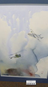
Painting, Jade & Possum Phuoc Tuy 1969, 2001
David Robson has had a lifelong association with aircraft. He started flying at the age of 16 and served for 21 years in the RAAF as a fighter pilot, test pilot and forward air controller (including a tour in Vietnam in the 0-2A). His hobby is painting, and he naturally turns to his own experiences and visual images to convey the wonders and beauty of flight, the camaraderie of the Services and ugliness of war.Original watercolour of USAF Cessna 0-2A supporting A/An Army Bell Helicopter in 1969 in Phuoc Tuy Province. Call sings Jade and Possum respectively. The scene portrayed in the watercolour is of a USAF Cessna 0-2A aircraft supporting an Australian Army Bell 47 helicopter in 1969. the team operated in Phuoc Tuy Province in support of the 1st australian Task Force. the 0-2A was a Forward Air Control aircraft flown by both USAF and RAAF pilips in this role. Jade 07 was the callsign reserved for a RAAF fighter pilot. As well as directing airstrikes in the Jad FAC gave top cover and navigational assistance to the Possum helicopter and , in return, the Possum provided very accurate BDA (Bomb Damage Assesment) following the airstrike.Signed by Artist David Robson 2001. cessna 0-2a, painting, phuoc tuy, david robson -
 Bendigo Military Museum
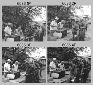
Photograph - Army Survey Regiment - Regimental Training BBQ, 1985
This is a set of 14 photographs of Army Survey Regiment personnel attending a BBQ lunch during regimental training, at the basketball/tennis court area of Fortuna Villa, Bendigo, 1985. There were six regimental training objectives outlined in the administrative instruction – Exercise “City Soldier” accompanying these photos. They were SLR rifle and M30 grenade revision, and first aid at Fortuna; RATEL and navigation at Wellsford Forest; and rifle shooting at Wellsford Rifle Range. Personnel from Air Survey, Cartographic, Lithographic and Headquarters Squadrons were reallocated to four training platoons for one week from 7th to 11th October 1985. Personnel were warned in for lunch on 10th and 11th of October 1985. This is a set of 14 photographs of Army Survey Regiment personnel attending a regimental training BBQ lunch at Fortuna Villa, Bendigo, 1985. .1P to .10P are printed on photographic paper and scanned at 300 dpi. Photos .11P to .14P are on 35mm negative film and scanned at 96 dpi. They are part of the Army Survey Regiment’s Collection. The photographs were printed on photographic paper and are part of the Army Survey Regiment’s Collection. .1) - Photo, black & white, 1985, L to R: unidentified personnel, PTE Evans, LCPL Brown - cooks, CAPT Laurie Newton, WO2 Brian Partridge, CAPT Danny Galbraith. MAJ Daryl Hockings CSM, unidentified personnel. .2) - Photo, black & white, 1985, L to R: unidentified personnel, PTE Evans, LCPL Brown - cooks, MAJ Mick Byrne, CAPT Bob Williams, unidentified, LT Doug Maxwell, WO2 Brian Partridge, CAPT Danny Galbraith. .3) - Photo, black & white, 1985, L to R: unidentified personnel, PTE Evans, LCPL Brown - cooks, CAPT Bob Williams, unidentified, LT Doug Maxwell, unidentified personnel. .4) - Photo, black & white, 1985, L to R: unidentified personnel, PTE Evans, LCPL Brown - cooks, LT Doug Maxwell, unidentified, CAPT John South, unidentified personnel. .5) - Photo, black & white, 1985, L to R: unidentified personnel, MAJ Terry Edwards - background, SGT Morris – cook. .6) - Photo, black & white, 1985, L to R: unidentified, CPL Gary Tremain, unidentified, MAJ Terry Edwards, 2LT Kathie Ryan – background. .7) - Photo, black & white, 1985, L to R: SGT Charlie Creedy, SGT Wally Chilcott, LT Carol Dunstan, 2LT Kathie Ryan, LT Ossie Slade. .8) - Photo, black & white, 1985, L to R: CPL Terry ‘TJ’ Wicker, unidentified personnel, SPR Roy Hicks, SPR Dave Wright, unidentified personnel. .9) - Photo, black & white, 1985, L to R: unidentified personnel, SGT Jeff Willey, SGT Wally Chilcott, CPL Gary Tremain. .10) - Photo, black & white, 1985, L to R: foreground - CPL Megan (McBurney) Reynolds, LCPL Bob Sheppard, CPL Bob Thrower, background - CPL Peter Breukel, WO1 Doug Arman, CPL Brian Johnson. .11) - Photo, black & white, 1985, L to R: RSM WO1 Bob Mason, PTE Evans, LCPL Brown - cooks, CAPT Danny Galbraith. .12) - Photo, black & white, 1985, L to R foreground: unidentified (x2), CPL Roy Hicks, CPL Megan (McBurney) Reynolds, unidentified (x2), CPL Peter Breukel, unidentified (x2), LT Ozzy Slade. .13) - Photo, black & white, 1985, L to R: LCPL Brown – cook, WO2 Brian Partridge, unidentified, WO2 John Hook, WO1 Bill Griggs, unidentified, CAPT Danny Galbraith, unidentified. .14) - Photo, black & white, 1985, L to R foreground: MAJ Kim Weston, CAPT Bob Williams, CAPT Danny Galbraith, unidentified, unidentified US Army Exchange officer..1P to .14P No personnel are identifiedroyal australian survey corps, rasvy, army survey regiment, army svy regt, fortuna, asr -
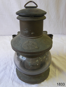 Flagstaff Hill Maritime Museum and Village
Functional object - Marine Lamp, James Paterson Lamp Manufacturer, 1880s to 1930s
The item is a kerosene marine ships lamp used onboard ships and smaller vessels for general lighting and navigation the subject lamp was made in Melbourne by a known maker James Paterson. The writer at this time cannot ascertain any significant historical information regarding the company or its founder, however lamps made by James Paterson of Melbourne are rare and regarded as collector's items and would command significant sale prices. All that is currently known is that the James Paterson Lamp manufacturing company were located at 30 Little Collins St Melbourne, and were active in Dec 1885 and in 1886 from newspaper articles of the time. Therefore the assumption is that the subject lamp was made in the late 19th to the first quarter of the 20th century.A significant item used in the marine industry on many ships, the company made kerosene lamps for other industries as well and was a well-known Melbourne based company in the late 19th and early part of the 20th centuries.Marine masthead copper ship's lamp with a handle at the top and holders at the side. It has a lamp glass and reflector mounted on a removable fuel tank. It was made in Melbourne by James Paterson.Stamped James Paterson Lamp Manufacturer 30 Little Collins St Melbourneflagstaff hill, warrnambool, flagstaff-hill-maritime-museum, maritime-museum, shipwreck-coast, flagstaff-hill-maritime-village, lamp, masthead brass ship's lamp, masthead lamp, james paterson, marine kerosene lamp