Showing 25249 items
matching north
-
 Whitehorse Historical Society Inc.
Document, History of the 7th Nunawading (1st North Blackburn) Scout Group, 1967
History of the 7th Nunawading (1st North Blackburn) Scout Group, formed in 1961.History of the 7th Nunawading (1st North Blackburn) Scout Group, formed in 1961.History of the 7th Nunawading (1st North Blackburn) Scout Group, formed in 1961.nunawading scout group, 7th, north blackburn scout group, 1st -
 Whitehorse Historical Society Inc.
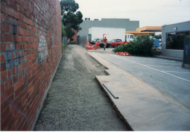
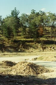
Photograph, Lane Reconstruction looking North towards Harrison Street, Mitcham, 1/06/1997 12:00:00 AM
Coloured photo of Lane Reconstruction looking North towards Harrison Street, Mitcham.harrison street, mitcham, mcdowall street -
 Whitehorse Historical Society Inc.
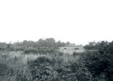
Photograph, Area North of Burwood Road near Dandenong Road, 1971
Black and White Photo of Area North of Burwood Road near Dandenong Road.to be entered -
 Whitehorse Historical Society Inc.
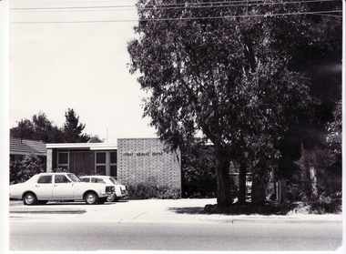
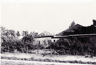
Photograph, North Blackburn Infant Welfare Centre, 1971
Blackburn and white photograph taken in 1971 of the North Blackburn Infant Welfare Centre.north blackburn infant welfare centre -
 Ballarat Heritage Services
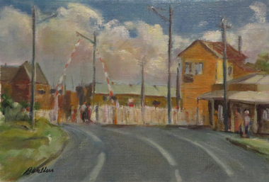
Artwork, Railway Gates at Humffray Street North, Ballarat, c2014
Photograph of an oil painting on paper of the railway gates at Humffray Street North, Ballarat.railway gates, ballarat railway, humffray street railway gates -
 Kew Historical Society Inc
Photograph, Floods in North Kew, 1934
Living with natural processes was frequently a challenge to early European settlers and later residents of what was in the 1850s administered by the Borondara Road Board. This was compounded by the area being bounded on three sides by rivers (Yarra River, Koonung Creek and Gardiner's Creek). In 1849, the historian James Bonwick recorded that "our district [Kew] suffered considerably. Mr Wade speaks of 80 acres, out of 100 acres of his cultivated paddock, covered by water." Newspapers continued to describe major flooding in Kew in 1863, 1869, 1878, 1880, 1889, 1891, 1916 and 1934. While the construction of the Upper Yarra dam in 1957 reduced the levels of flowing downstream, local and riverine floods continue.The Kew Historical Society's pictures and map collections testify to the impact of flooding in the district. They have historical importance in documenting the extent of flooding in the district and its affects on homes, services and recreation. Numerous photographs record flooding throughout the Twentieth Century.Floods in North Kew, 1934. Unidentified location on the Yarra Flood Plain at Kew.floods (kew) 1934, yarra river -
 Brimbank City Council Art Collection
Photograph, Robert Pointon, West Bank of the Kororoit Creek looking north, 1988
Local SceneHuntsman Chemical works, West Bank of the Kororoit Creek looking north - AR0019 -
 Brimbank City Council Art Collection
Photograph, Robert Pointon, Kororoit Creek looking North east, 1993
Local SceneKororoit Creek looking North east with the Albion explosive site in the background - AR0020 -
 Ballarat Heritage Services
Photograph, Ballarat looking North West from the Former Humffray Street Primary School, 12/91/2019
Ballarat looking North West from the Former Humffray Street Primary Schoolballarat, humffray street primary school, ballarat railway station, mair street -
 Ringwood and District Historical Society
Photograph, View north from Avery Court over valley of the golf course. North Ringwood 1981
Written on back of photograph, "24/8/81. View north from Avery Court over valley of the golf course. Tortice Drive passes the end of Avery Crt, 75 metres behind the camera". -
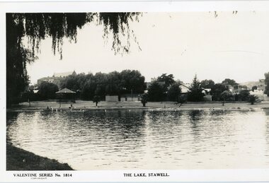 Stawell Historical Society Inc
Photograph, Cato Lake looking North Pre c 1930 -- Postcard
Post Card Valentine Series pre 1930. "The Lake" Stawell. The lake has been renamed and now called Cato Lake. This view is looking north and shows distant buildings of Stawell behind a line of trees. People can be seen enjoying the lake walking and swimming with a rotunda between the trees and the lake. Valentine Series post card of The Lake, Stawell looking north pre 1930's. The back of the Coffee Palace can be seen on the left back and the roof of the Anglican church can be seen above the trees. The other side to the right are houses in Florence Street. Along the lake are people walking and enjoying the waters edge swimming. A rotunda is to the left and the post card is framed by an overhanging willow tree. Valentine Series No 1814 The Lake, Stawell. Valentine Publishing Co. Melbourne & Sydney.stawell -
 Ringwood and District Historical Society
Photograph, Looking north down Werac Drive, North Ringwood with lake headwater's site behind light standard on left in February 1979
B552 N19 Part of a 51-photo record of the development of the "Kubis" Estate, Ringwood North, including road works to Debbie Place, Kubis Drive, Werac Drive, Manuelo Drive, Iluka Place and Glenvale Road. From the Jack Lundy Clarke collection. -
 Ringwood and District Historical Society
Photograph, Kubis Estate, North Ringwood in February 1978. The site of Loughnan's Lake seen from the north end of the wall. The rope tree was on the hillside on the left
E546 N2 Part of a 51-photo record of the development of the "Kubis" Estate, Ringwood North, including road works to Debbie Place, Kubis Drive, Werac Drive, Manuelo Drive, Iluka Place and Glenvale Road. From the Jack Lundy Clarke collection. -
 Ringwood and District Historical Society
Photograph, "Kubis Estate", North Ringwood, in April 1978. Looking north-east over Loughnan's Lake greatest width. The rope tree was on the slope in the centre. The spillway was on the near left of the image
E548 N17 Part of a 51-photo record of the development of the "Kubis" Estate, Ringwood North, including road works to Debbie Place, Kubis Drive, Werac Drive, Manuelo Drive, Iluka Place and Glenvale Road. From the Jack Lundy Clarke collection. -
Whitehorse Historical Society Inc.
Document, History of Blackburn North State School No 4715, c1970
Document re establishment of Blackburn North Primary School on 5 acres of land on the North Side of Springfield Road. Opened 5 April 1954 with initial enrolment of 237 pupils, also listing staff and school committee members.blackburn north primary school, primary schools, jenkins, p, cole, j -
 Ringwood and District Historical Society
Photograph, Looking north from between Werac and Kubis Drives, North Ringwood, in February 1978
E546 N3 Part of a 51-photo record of the development of the "Kubis" Estate, Ringwood North, including road works to Debbie Place, Kubis Drive, Werac Drive, Manuelo Drive, Iluka Place and Glenvale Road. From the Jack Lundy Clarke collection.51 -
Ringwood and District Historical Society
Documents, Ringwood and North Ringwood Community Fairs - documents 1995, 7-May-95
Group includes Ringwood Art Society and Norwood Park Centre, including promotions update.Documents about the organisation for the Ringwood and North Ringwood community fairs - May 1995. 10pp. -
Glenelg Shire Council Cultural Collection
Photograph, Refrigerated shipping containers on railway carriages at North Portland, n.d
Port of Portland Authority archives.Front: (no inscriptions) Back: (no inscriptions) -
Ringwood and District Historical Society
Envelope, Packet: Records of reports and accounts of Ellie Pullin Pre-School, Tortice Drive North Ringwood
Records of reports and accounts of Ellie Pullin Pre-School, Tortice Drive North Ringwood -
Whitehorse Historical Society Inc.
Book, Blackburn North Baptist Church, c1985
Blackburn North Baptist Church : a church that cares. History of the church written as a school assignmentBlackburn North Baptist Church : a church that cares. History of the church written as a school assignmentBlackburn North Baptist Church : a church that cares. History of the church written as a school assignmentblackburn north baptist church, school assignment -
 Whitehorse Historical Society Inc.
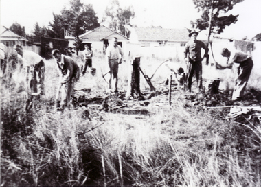
Photograph, North Blackburn Methodist Church, 1/05/1955 12:00:00 AM
Black and white photograph of the clearing of the site for the North Blackburn Methodist Church, May 1955.north blackburn methodist church, bird, neville -
 Whitehorse Historical Society Inc.
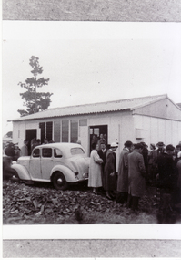
Photograph, North Blackburn Methodist Church, 1955
Black and white photograph of North Blackburn Methodist Church known as the 'Folding Church' in 1955.north blackburn methodist church, bird, neville, folding church -
 Whitehorse Historical Society Inc.
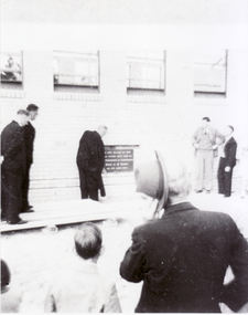
Photograph, North Blackburn Methodist Church, 1957
Black and white photograph of laying of foundation stone for the North Blackburn Methodist Church in 1957.north blackburn methodist church, bird, neville -
 Whitehorse Historical Society Inc.
Photograph - B/W Photograph, House in Blackburn North incorporating part of Slater's Perfume Distillery, 1/06/1969 12:00:00 AM
Black and white photo of House in Blackburn North incorporating part of Slater's Perfume Distillery.June 1969slater house, perfumery -
 Whitehorse Historical Society Inc.
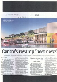
Article, North Blackburn Shopping Centre Revamp
North Blackburn Shopping Centre is awaiting council approval for a revamp costing $40 million.North Blackburn Shopping Centre is awaiting council approval for a revamp costing $40 million.North Blackburn Shopping Centre is awaiting council approval for a revamp costing $40 million.blackburn north shopping centre, city of whitehorse -
 Whitehorse Historical Society Inc.
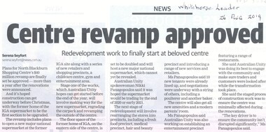
Article, North Blackburn Shopping Centre, 2019
Plans for the North Blackburn Shopping Centre's $40 million revamp are finally set to be approved.Plans for the North Blackburn Shopping Centre's $40 million revamp are finally set to be approved.Plans for the North Blackburn Shopping Centre's $40 million revamp are finally set to be approved.north blackburn square shopping centre, revamp -
 Whitehorse Historical Society Inc.
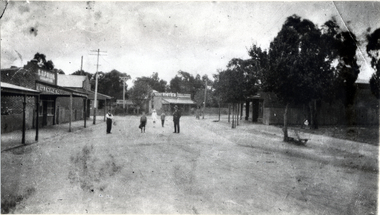
Photograph - Black and white photograph, Blackburn Road looking north from railway gates, 1920
Used by donor in 'Blackburn - a picturesque history'Black & white photo of Blackburn Road looking North from railway gates in Blackburnblackburn road blackburn, blackburn railway station -
 Ballarat Heritage Services
Photograph, Ballarat Looking North-east from the Town Hall Tower, 14/12/1895
Photograph published in the Australasian of Ballarat Looking North-east from the Town Hall Towerballarat, ballarat town hall, ballarat post office, ballarat railway station -
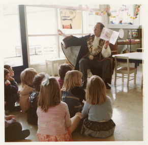 Ballarat Heritage Services
Photograph - Colour, City of Kew Mayor, Cr John H. Gervasoni at North Kew Kindergarten, c1972
Colour photograph of Mayor Cr Jack Gervasoni reading a story at NOrth Kew Kindergarten. north kew kindergarten, john hogan gervasoni, mayor, city of kew -
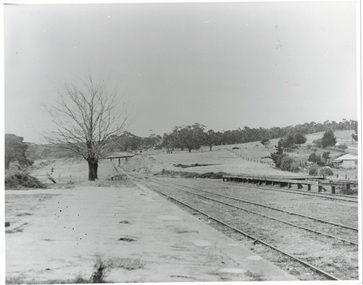 Buninyong & District Historical Society
Photograph - Photo of Original Photograph, Wal Larsen, B/W photo of Buninyong Railway Station platform, looking north, in June 1940, June 1940
Railway and surrounds in 1940.B/W photo of Buninyong Railway Station platform, looking north in June 1940buninyong, railway, bunny, cutting, station, platform