Showing 488 items matching "north avenue"
-
 Ringwood and District Historical Society
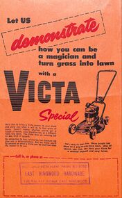
Document, An advertisement for the Victa Special mower from East Ringwood Hardware, accredited Victa Agent. 102 Railway Avenue, East Ringwood, WU 6092
-
 Ringwood and District Historical Society
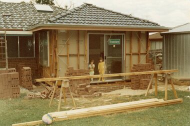
Photograph, Adding a room onto the Mitchell house at 168 Oban Road, North Ringwood in February 1979
Near the corner of Cormistom Road and Florence Avenue onto Oban Road. The house is still there today (2024).Taken by Roy J Mitchell -
 Ringwood and District Historical Society
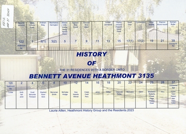
Book, History of Bennett Avenue Heathmont 3135, compiled by Laurie Allen, Heathmont History Group and the residents. 2023
Soft cover book of 31 pages with spiral wire spine.Cover depicts each residence number with corresponding owners name. -
 Ringwood and District Historical Society
Mixed media - Video, RDHS Guest Speaker Presentation - "Heathmont 2020 Highlights" - Gerry Robinson and Peter Le Get
Digitised video (1.11GB). Duration: 20 minutes. Recorded March, 2021. (Video is available for viewing at Ringwood & District Historical Society Archives by appointment)Presenters: Gerry Robinson and Peter Le Get of Heathmont History Group (HHG) look back over developments in the area over the previous year. HEATHMONT HIGHLIGHTS FOR 2020 Summary - "Of course for 2020 the Covid 19 virus dominated. Other finalists included roadworks on Bedford Road corner, new Wards for MCC and their elections, 100th birthday and death of Rita James, opening of Milk & Wine Co. café replacing Barclays, election of Kylie Spears as Mayor, closure of Heathmont Medical Centre, demolition of Miller homestead in Coven Avenue, final edition of Maroondah Leader local newspaper, opening of HE Parker Sports pavilion, 50 more bollard arts, and the ugliness of the former Anglican Church and other local sites." -
 Ringwood and District Historical Society
Mixed media - Video, RDHS Meeting Presentation - "The World of Joan Bilceaux" - Russ Haines
Digitised video (2.61GB). Duration: 61minutes. Recorded March, 2021 (Video is available for viewing at Ringwood & District Historical Society Archives by appointment)In this talk, Ringwood and District Historical Society President Russ Haines takes us through the early history of the Birt's Hill / Croydon Road area, the former locations of the Bilcock and Hardidge families. The Bilcock family had one of the early general stores in Kent Avenue and later moved to Toorak Avenue, Croydon. The father, David Bilcock was a talented film maker. His daughter, Joan Bilceaux, was a renown singer, model and actor, having varied the spelling of her surname as her chosen professional name. -
 Ringwood and District Historical Society
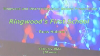
Mixed media - Video, RDHS Meeting Presentation - "Ringwood's First School" - Russ Haines
Digitised video (894MB). Duration: 20 minutes. Recorded February, 2023 (Video is available for viewing at Ringwood & District Historical Society Archives by appointment)As a follow up to the recent centenary celebrations of the 1921 Ringwood State School building in Greenwood Avenue, Ringwood and District Historical Society President Russ Haines presents this look back at the often overlooked earlier history of the village of Ringwood, including the establishment of Cass' School in 1874 on five acres of land between Dublin Road and Everard Road, becoming Ringwood's first school. -
 Ringwood and District Historical Society
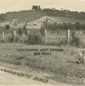
Document - Property Titles, Transfer of Land Act - "Pinemont", Ringwood, Victoria
Folder containing copies of LANDATA documents relating to "Pinemont", Panorama Avenue, Ringwood, Victoria, compiled for potential real estate sales background information purposes. Title Vol 965 Fol 923 Allotment 27B Parish of Warrandyte - James Forbes, dated 30th August, 1876. Title Vol 5236 Fol 1947157 Lots 294 and 370 on Plan of Subdivision no.11392 - Anthony Loughnan, dated 4th March, 1927. Title Vol 6415 Fol 1282937 Lot 294 on Plan of Subdivision no.11392 - Jessie McCracken Rothwell Woodard, dated 9th September, 1940. -
 Ringwood and District Historical Society
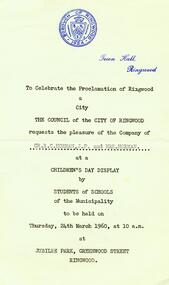
Photograph, Invitation to celebration of the proclamation of Ringwood as a City on 24th March 1960 at Jubilee Park, Greenwood Avenue - a Children's Day Display by students of schools of the municipality. To Cr RC Horman JP and Gwen Horman
Invitation to celebration of the proclamation of Ringwood as a City on 24th March 1960 at Jubilee Park, Greenwood Avenue - a Children's Day Display by students of schools of the municipality. To Cr RC Horman JP and Gwen Horman. All material is from Gwen Horman’s three albums that she owned. -
 Ringwood and District Historical Society
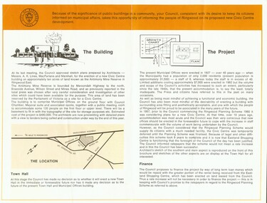
Photograph, City of Ringwood Council document (June 1968) highlighting new Civic Centre build in Braeside Avenue, Ringwood
City of Ringwood Council document (June 1968) highlighting new Civic Centre build in Braeside Avenue, Ringwood -
 Ringwood and District Historical Society
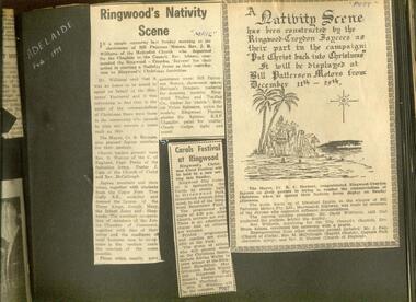
Newspaper, Rev. Williams of the Ringwood Methodist Church opens the nativity scene in Bill Paterson's Motors and Council's Carols in Greenwood Avenue Park
-
 Ringwood and District Historical Society
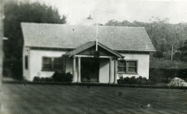
Photograph, Ringwood Bowling Club- New Clubrooms, 1931
Black and white photographRingwood Bowling Club- New Clubrooms at Miles Avenue, 1931. -
 Ringwood and District Historical Society
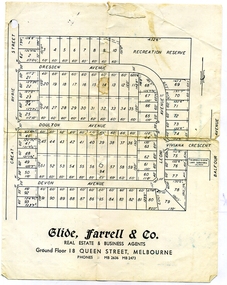
Document, Glen Turnbull, Land Sale Brochure - Heathmont Hills Estate - subdivision of Stan Wieland's Land (undated), 25/2/2008
Small brochure by Glide Farrell & Co, real estate and Business Agents, Melbourne advertising "93 Superb Building Blocks 3Mins Station & Shops", and "Sky-Line Views of Heathmont Hills Estate" , comprising lots in Dresden Ave, Doulton Ave, Devon Ave, Viviana Crescent, Leoni Avenue. -
 Ringwood and District Historical Society
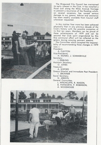
Photograph, Ringwood Bowling Club- Installation of flood wall along the Miles Avenue frontage, 1979
Black and white photographs (2)Photographs show volunteers constructing the flood wall along the Miles Avenue frontage. Text attached to photos includes names of Committee Members who accepted the responsibility of recommending changes in 1979 including the flood wall. -
 Ringwood and District Historical Society
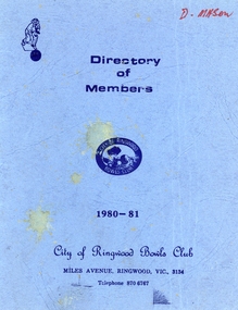
Booklet, Ringwood Bowls Club- Directory of Members, 1980-81
Blue coloured bookletOn front cover Directory of Members, 1980-1981 City of Ringwood Bowls Club Miles Avenue, Ringwood, Vic, 3134. Inside booklet is typed list of Members in alphabetical order with address and phone number. -
 Ringwood and District Historical Society
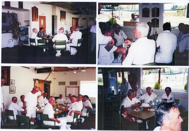
Photograph, Ringwood Bowls Club- Miscellaneous photographs at old Club in Miles Avenue and new Club in Laughnan Road, 1997 to 1999
Coloured photographs(34)Photographs include: Club personalities at old Club . Internal and external images of new Clubrooms and greens. Various team photographs. Final Premier Division 1999. Images 30210(a) to 30210(i). -
 Ringwood and District Historical Society
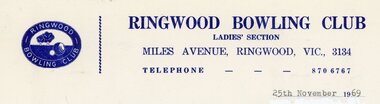
Document, Ringwood Bowls Club- Letterhead, Ringwood Bowling Club, Ladies Section, 1969
Copy of Letterhead.Ringwood Bowling Club Ladies Section Miles Avenue, Ringwood, Vic., 3134. Telephone: 870 6767. 25th November 1969 -
 Ringwood and District Historical Society
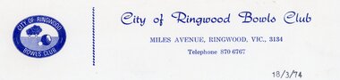
Document, Ringwood Bowls Club- Letterhead, City of Ringwood Bowls Club, 1974
Copy of Letterhead.City of Ringwood Bowls Club Miles Avenue, Ringwood, Vic., 3134. Telephone: 870 6767. 18/3/74. -
 Ringwood and District Historical Society
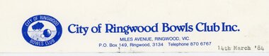
Document, Ringwood Bowls Club- Letterhead, City of Ringwood Bowls Club Inc., 1984
Copy of Letterhead.City of Ringwood Bowls Club Inc. Miles Avenue, Ringwood, Vic., 3134. P.O. Box 149, Ringwood, 3134. Telephone: 870 6767. 14th March, 1984. -
 Ringwood and District Historical Society
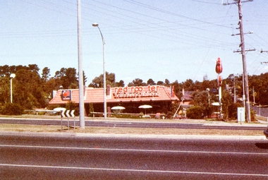
Photograph, Red Rooster Barbecued Chicken shop at the corner of Cutts Avenue and Maroondah Highway, east side in 1985
Photo taken by Marion Mitchell (nee Robinson) in 1985. The shop was often pranked by removing the "s" from rooster. -
 Ringwood and District Historical Society
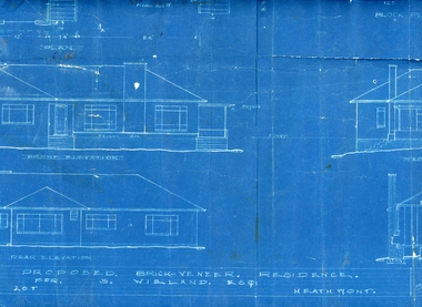
Plan, Architects plan for residence in Balfour Avenue, Heathmont for Stan Wieland , no date
Stanley Wieland took over the property called "Fairview" at the corner of Dickasons Road and Canterbury Road, Heathmont after his Father's death in 1945. He married Thelma Wilson in 1930. Their daughter Pat wrote the Wieland History with her husband Don Talbot.Architect's plan on heavy blue paper for residence at Balfour Avenue , Heathmont -
 Ringwood and District Historical Society
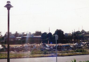
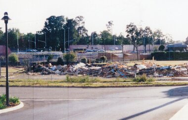
Photograph, Ringwood Bowls Club- Demolition of old Club and greens, 1997
Coloured photographPhotograph shows piled up rubbish of demolished building of old Club in Miles Avenue. -
 Ringwood and District Historical Society
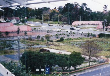
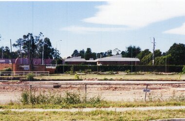
Photograph, Ringwood Bowls Club- Demolition of old Club and greens, 1997
Coloured photographPhotograph shows dug up greens of old Club in Miles Avenue. -
 Ringwood and District Historical Society
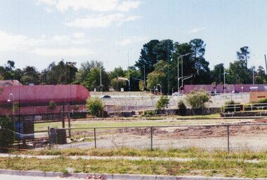
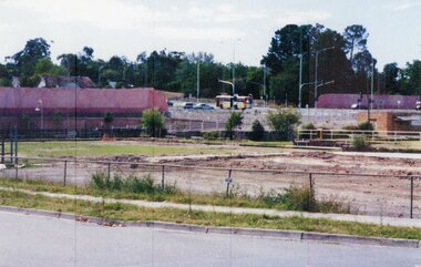
Photograph, Ringwood Bowls Club- Demolition of old Club and greens, 1993
Coloured photographPhotograph shows piled up rubbish of demolished building of old Club in Miles Avenue. -
 Ringwood and District Historical Society
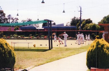
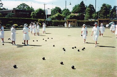
Photograph, Ringwood Bowls Club- Demolition of old Club and greens, 1993
Coloured photographPhotograph shows bowlers playing at old Club in Miles Avenue. -
 Ringwood and District Historical Society
Photograph, Ringwood Bowls Club- Demolition of old Club and greens, 1993
Coloured photographPhotograph shows remnants of demolished old Club in Miles Avenue. -
 Ringwood and District Historical Society
Photograph, Ringwood Bowls Club- Demolition of old Club and greens, 1993
Coloured photographPhotograph shows remnants of demolished old Club in Miles Avenue. -
 Ringwood and District Historical Society
Photograph, Ringwood Bowls Club- Demolition of old Club and greens, 1993
Coloured photographPhotograph shows remnants of demolished old Club in Miles Avenue. -
 Ringwood and District Historical Society
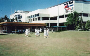
Photograph, Ringwood Bowls Club- Demolition of old Club and greens, 1993
Coloured photographPhotograph shows bowlers playing at old Club in Miles Avenue. -
 Ringwood and District Historical Society
Photograph, Ringwood Bowls Club- The last Ladies Pennant game at Miles Avenue, 1997
Coloured photographPhotograph shows ladies playing a game at Miles Avenue. -
 Ringwood and District Historical Society
Photograph, Ringwood Bowls Club- The last Ladies Pennant game at Miles Avenue, 1997
Coloured photographPhotograph shows ladies playing a game at Miles Avenue.