Showing 418 items
matching orchard district
-
 Ringwood and District Historical Society
Photograph, Rear of Jack Williams' orchard, Mullum Road - 1964
Written on backing sheet, "Rear Jack Williams' orchard, Mullum Road - 1964". -
 Ringwood and District Historical Society
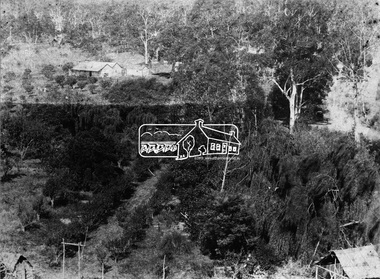
Photograph, Looking across remains of Frazer's orchard to state school, 1972
Updated Information from Bruce Frazer: This is Frazer's (not "Fraser") orchard, sold to A.V. Jennings Co. For housing development c1970. Address was "Alkoomi", Oban Rd. North Ringwood. State School 4120 was enclosed on its north & east sides by the orchard. Owned by Harold & Sylvia Frazer, 12 acres, growing mainly cherries plus plums & lemons. Photo was taken from neighbouring apple orchard (Williams) & shows street construction in the middle distance.Written on back of photograph, "Looking across remains of Fraser's orchard to state school, 1972". -
 Ringwood and District Historical Society
Photograph, Remains of Frazer's orchard, North Ringwood. State school on left - 1972
Updated Information from Bruce Frazer: This is Frazer's (not "Fraser") orchard, sold to A.V. Jennings Co. For housing development c1970. Address was "Alkoomi", Oban Rd. North Ringwood. State School 4120 was enclosed on its north & east sides by the orchard. Owned by Harold & Sylvia Frazer, 12 acres, growing mainly cherries plus plums & lemons. Photo was taken from neighbouring apple orchard (Williams) & shows street construction in the middle distance.Written on back of photograph, "Remains of [Fraser's] orchard. State school on left". -
 Ringwood and District Historical Society
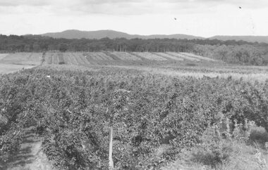
Photograph, View from Wonga Rd. over Mullum Rd. (centre) and beyond - 1946. Orchards: French, Vergers
"View from Wonga Rd. looking east towards Mullum Rd. 1946" and "Looking from Wonga Rd. over Mullum Rd. (centre) and beyond. Orchards: French, Vergers". -
 Ringwood and District Historical Society
Photograph, Panfield Estate 1960 (off Mullum Rd.) previously Vic. Hunter's Orchard
Typed below photograph, "Panfield Estate 1960 (off Mullum Rd.) previously Vic. Hunter's Orchard. 1960". "Panfield Ave. off Mullum Rd. to Wonga Rd." -
 Ringwood and District Historical Society
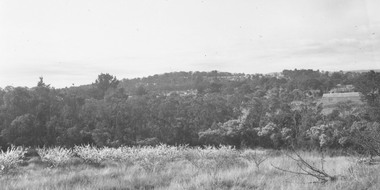
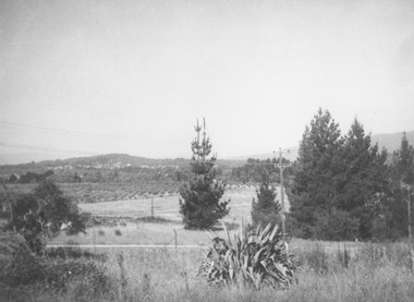
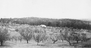
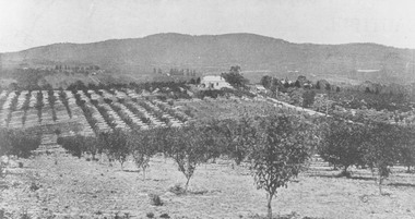
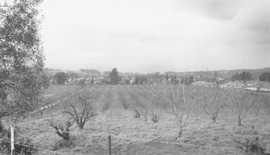
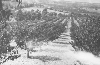
Photograph, Site of Norwood High School. Orchard leased by Peter Vergers, owned by Airds." Dated 1958
Black and white photograph of orchard in bloom. Settled area in mid ground with hills in background.Typed below photograph, "Site of Norwood High School. Orchard leased by Peter Vergers, owned by Airds." Dated 1958. -
 Ringwood and District Historical Society
Photograph, Site of William's Orchard, Mullum Rd. 1964
Written on backing sheet, "Site of William's Orchard, Mullum Rd. 1964". -
 Ringwood and District Historical Society
Photograph, Mr. F. Goulding's orchard. Looking across to Ringwood East from Wonga Rd. 1960
Typed below photograph, "Mr. F. Goulding's orchard. Looking across to Ringwood East from Wonga Rd. 1960". -
 Ringwood and District Historical Society
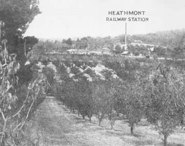
Photograph, Herman Pump's orchard looking towards Heathmont Railway Station 1927. Station and platform on left
Typed below photograph, "Herman Pump's orchard looking towards Heathmont Railway Station 1927. Station and platform on left". -
 Ringwood and District Historical Society
Photograph, Godbehear's orchard in Warrandyte Road North Ringwood, prior to subdivision. (undated)
Typed below photograph, "Godbehear's orchard prior to subdivision". -
 Ringwood and District Historical Society
Photograph, From Wonga Road, overlooking Jack Aird's orchard. (undated)
Typed below photograph, "From Wonga Road, overlooking Jack Aird's orchard". -
 Ringwood and District Historical Society
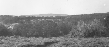
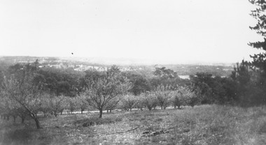
Photograph, Overlooking Heathmont from Pump's orchard - 1926
Black and white photograph of orchard. Housing in distance.Typed below photograph, "Overlooking Heathmont from Pump's orchard, 1926". -
 Ringwood and District Historical Society
Photograph, View of what was Heathmont township taken from about Royal Avenue looking at Mr. Herman Pump's orchard. Old bridge over Canterbury Road can be seen on left
Typed below photograph, "View of what was Heathmont township taken from about Royal Avenue looking at Mr. Herman Pump's orchard. Old bridge over Canterbury Road can be seen on left." -
 Ringwood and District Historical Society
Photograph, View from Canterbury Road/Balfour Avenue area overlooking Martell's orchard, Heathmont, 1929
Black and white photograph of orchard. House in middle range, mountains in background. Photograph appears to be reproduced from subdivisional brochure. Note inserted in sleeve reads, "It has been pointed out that the mountains are to the east and the view is looking south. This therefore is not a 'straight' photograph. House still exists in Eden Avenue at October, 1996".(3 copies).Typed below photograph, "Panoramic view taken on the estate". "View overlooking Martell's orchard, Heathmont, 1929". Taken from corner Canterbury Rd. and Balfour Ave. looking south. Dandenong Creek just beyond house. Washusen Rd. on right". Written on back of one of the copies, "Heathmont Station Estate 1922". "Station Street, Lisgoold St. Canterbury Rd. Vivienne Cres. Balfour Ave." -
 Ringwood and District Historical Society
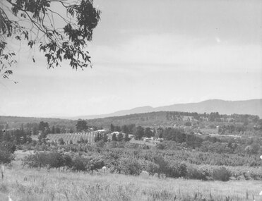
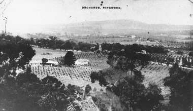
Photograph, View of Ringwood from Loughnans Hill. Pollards tank stand (centre) is on south side of Warrandyte Road. (Later location of Lauriston Crt.)
Black and white photograph looking down on orchards. House in centre of photograph, mountains in background. (3 copies)Written on back of one photograph, "Pollards tank stand" (centre) -
 Ringwood and District Historical Society
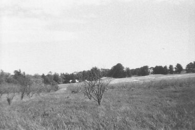
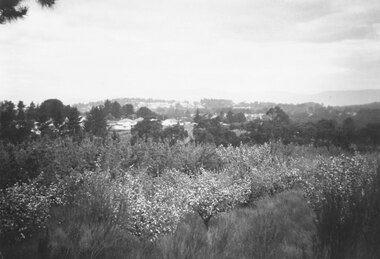
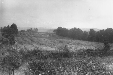
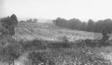
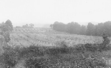
Photograph, John Vergers orchard Mullum Rd. Subdivided 1965
Black and white photograph of view looking across a paddock. Trees and hills in background.Typed below photograph, "John Vergers orchard Mullum Rd. Subdivided 1965". -
 Ringwood and District Historical Society
Photograph, John Vergers orchard in Mullum Rd. 1967
Written on backing sheet, "John Vergers orchard in Mullum Rd. 1967. -
 Ringwood and District Historical Society
Photograph, Godbehear's orchard - Warrandyte Rd. Prior to subdivision
Written on backing sheet, "Godbehear's orchard - Warrandyte Rd. Prior to subdivision". -
 Ringwood and District Historical Society
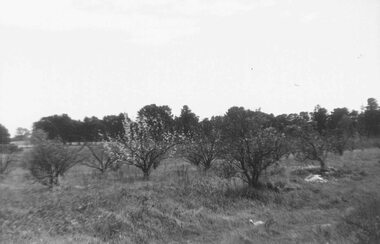
Photograph, Godbehear's orchard, Warrandyte Rd near Melview Drive area. 1960
Black and white photograph of orchard. Pine trees along back boarder. (3 copies - 1 small plus 2 enlargements). -
 Ringwood and District Historical Society
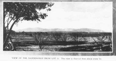
Photograph, Mullers orchard, Heathmont. Looking east from cnr. Canterbury and Dickasons Rds. "Charm View Estate" - 1926
Printed below photograph, "View of the Dandenongs from Lot 11. This view is observed from almost every lot". Written on back of a photograph, "Photo taken from sub. div. plan land sales. Charm View Estate, Heathmont, 1926?" Another copy reads, "Mullers orchard, Heathmont. Taken from cnr. Canterbury and Dickasons Rds. Looking east - 1926". -
 Ringwood and District Historical Society
Photograph, John Vergers orchard, Mullum Road - 1964
Typed below photograph, "John Vergers orchard, Mullum Road - 1964". -
 Ringwood and District Historical Society
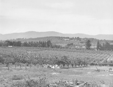
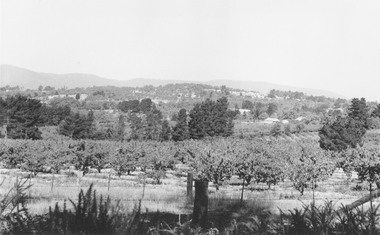
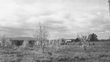
Photograph, Frank Pyke's apple orchard Ringwood. c1948/9
Black and white photographWritten on back of photograph- "Frank Pyke's apple orchard. See booklet 'Welcome to R/wood' 1948 or 1949. H. F. Pearson Mayor 1948 - 1949."agriculture -
 Ringwood and District Historical Society
Photograph, McKinley Orchard. Site of Norwood High School. c1920
Black and white photograph (3 copies)Written on back of one photograph- "McKinley Orchard. Site of Norwood High School. Taken from back of 18-20 Wonga Rd."agriculture -
 Ringwood and District Historical Society
Photograph, Kingswood Grove Estate, 1959. Formerly the orchard of Jack Godbehear
Catalogue card reads, "Kingswood Grove Estate, 1959. Formerly the orchard of Jack Godbehear. Photo taken from the bottom of Lot 5, corner Warrandyte Rd. and Roseband Ave." -
 Ringwood and District Historical Society
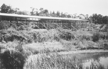
Photograph, Norwood High School - frame under construction
Written on back of photograph, "Norwood High. Built on orchard leased by Peter Vergers and owned by A. Aird, Wonga Road". -
 Marysville & District Historical Society
Photograph (Item) - Black and white photograph, Fernshaw, c1900
An early black and white photograph taken at Fernshaw.An early black and white photograph taken at Fernshaw. Fernshaw was a rural township 63 km north-east of Melbourne and 10 km north-east of Healesville. Situated on the Watts River, near where a log had fallen making a convenient crossing, Fernshaw was settled in the 1860s. It provided good country for orchards and berry growing. The location was at the foot of Blacks Spur, with Mounts Juliet and Mondah rising on either side, providing spectacular scenery. There were nearby fern gullies giving rise to the name – ‘shaw’ is old English for thicket or wood. By 1875 Fernshaw had a post office (1865), two hotels, a school (1871) and stores. It was famed for its beauty, attracting tourists. In 1886 the Melbourne and Metropolitan Board of Works began work on the Watts River water catchment scheme – later to become Maroondah – and the Board obtained approval for the catchment country to be reserved and kept free of settlement. This required the removal of the Fernshaw township, which was completed by about 1890. The area was described in the 1903 Australian handbook:ARMSTRONG COLLECTION 42 STATION STREET/ SANDRINGHAM 3191/ TEL. (03) 9521 5442/ IAN M.L. ARMSTRONG OAMfernshaw, healesville, watts river, orchard, berry orchard, blacks spur, black spur, mount juliet, mount mondah, maroondah dam, victoria -
 Eltham District Historical Society Inc
Photograph, Allwood, Hurstbridge, 1885
Allwood at Hurstbridge was named and first settled in 1837 by the Haley family. A house was built of one round of vertical slabs (red gum). Later it was the Hurst family home where Henry Hurst was shot by Burke the Bushranger on 4 October 1886. George Gray took over the property and the original home was eventually demolished. Gray, a fruit grower established an orchard and Allwood Nurseries which became a very successful business growing and exporting. This is probably around the time when this photo was taken where rows of fruit trees can be seen in the foreground. A house and associated buildings, possibly part of the nursery are behind. This photo forms part of a collection of photographs gathered by the Shire of Eltham for their centenary project book, "Pioneers and Painters: 100 years of the Shire of Eltham" by Alan Marshall (1971). The collection of over 500 images is held in partnership between Eltham District Historical Society and Yarra Plenty Regional Library (Eltham Library) and is now formally known as 'The Shire of Eltham Pioneers Photograph Collection.' It is significant in being the first community sourced collection representing the places and people of the Shire's first one hundred years.Digital imagesepp, shire of eltham pioneers photograph collection, diamond creek, hurstbridge, allwood, orchard -
 Eltham District Historical Society Inc
Negative - Photograph, Allwood, Hurstbridge, 1899
Allwood, Hurstbridge, 1899. Gray family in the garden in front of the Victorian style Allwood house with lace iron work on the verandah. Left to Right: - , - , William George Gray (3rd from left),. Frances Ellen Gray (nee Hurst) and William Hurst Gray (on lap). Carrie Sharp, Rob Sharp, Holmstrong. Frederick and Catherine Hurst relocated this Victorian style weatherboard home from an inner Melbourne suburb to its present site on their Allwood property. Mr Charles Verso, builder and farmer, reassembled and refurbished the home for the Hurst’s. In 1897 Frederick and Catherine’s daughter, Frances Ellen, married William (Bill) George Gray of Cottlesbridge and the newlyweds moved into the new house. Frederick and Catherine Hurst moved into a little cottage, ‘Mia Mia’, on the other side of the Diamond Creek. William and Frances Gray established Allwood Nursery and by 1900 most of the Allwood property was under orchard, largely apples, pears, cherry plums and peaches. They also developed an extensive nursery, growing seedling stock for supply to other local orchardists and the overseas market. Cross Ref: Sepp_1022 This photo forms part of a collection of photographs gathered by the Shire of Eltham for their centenary project book, "Pioneers and Painters: 100 years of the Shire of Eltham" by Alan Marshall (1971). The collection of over 500 images is held in partnership between Eltham District Historical Society and Yarra Plenty Regional Library (Eltham Library) and is now formally known as 'The Shire of Eltham Pioneers Photograph Collection.' It is significant in being the first community sourced collection representing the places and people of the Shire's first one hundred years.Digital image 4 x 5 inch B&W Negshire of eltham pioneers photograph collection, hurstbridge, allwood, carrie sharp, frances ellen gray (nee hurst), holmstrong, hurst family, rob sharp, william (bill) george gray, william hurst gray -
 Eltham District Historical Society Inc
Photograph, Diosma Road, Eltham, 15 October 1990, 15/10/1990
Colour photographinfrastructure, shire of eltham, streets, diosma road, eltham, stokes orchard estate -
 Eltham District Historical Society Inc
Photograph, Bettina Woodburn, Apted's Orchard, 864 Cottles Bridge-Strathewen Rd, Arthurs Creek, 28/05/1995
Autumn Excursion to St Andrews, Arthurs Creek and Strathewen, 28 May 1995.Colour photographactivities, apted's orchard, arthurs creek, cottles bridge-strathewen rd