Showing 2288 items matching "parishes"
-
 Bendigo Historical Society Inc.
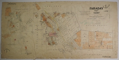
Map - FARADAY, 10/01/1879
Map: Parish of Faraday, County of Talbot. Parish plan. Draughtsman J T Thomson December 1877. Examined by J H Morgan 8/11/78map, talbot, parish plan, faraday, j. h. morgan, j. t. thomson -
 Linton and District Historical Society Inc
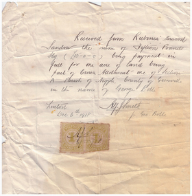
Receipt, Receipt for Payment for a Block of Land near Linton, 1918
Note that the block of land which was traded was not the block in Sussex Street, Linton on which the Sandows had a shop and house, but a block just outside the town boundary, near the Geelong Road (Linton-Naringhil Road). See map of Parish of Argyle for clarification.Photocopy of original handwritten receipt, which was for payment in full for a block of land situated just outside of Linton - Section A, Crown Allotment 1, Parish of Argyle. This land was purchased by Rubina (Ruby) Sandow from George Bolte in 1918. Receipt is for fifteen pounds, it is made out to "Rubinia Norwood Sandow" and is signed by Alf J. Smith, "for Geo. Bolte". Two Victorian Stamp Duty stamps are attached to the original document.rubina (ruby) sandow, george bolte, receipts, sale of land -
 Bendigo Historical Society Inc.
Map - JACK FLYNN COLLECTION: TARNAGULLA, 13/05/1922
Map: Parish of Tarnagulla . This Item is in very poor condition.By Authority, A. J. Mullen, Government Printer, Melbourne. Lithographed at the Department of Lands and Survey, Melbourne by W. J. Butsonmap, gladstone, parish plan, tarnagulla -
 Bendigo Historical Society Inc.
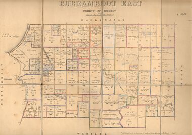
Map - JACK FLYNN COLLECTION: BURRUMBOOT EAST, 21/12/1027
Map: Burrumboot East, County of Rodney. Parish plan.Photo Lithographed at the Department of Lands and Survey, Melbourne by W.J.Butson. 21.12.27map, rodney, parish plan, burrumboot east -
 Bendigo Historical Society Inc.
Map - JACK FLYNN COLLECTION: ECHUCA NORTH, November 1953
Map: Echuca North, County of Rodney. Parish plan.By Authority: W.M. Houston, Government Printer. Drawn and Reproduced at the Dept., of Lands and Survey Melbourne, Victoria. November 1953map, rodney, parish plan, echuca north rodney -
 Bendigo Historical Society Inc.
Map - CITY OF SANDHURST SHEET NO.6, 25/04/1882
Map: City of Sandhurst sheet No. 6. Parish planmap, bendigo, parish plan, sandhurst -
 Robin Boyd Foundation
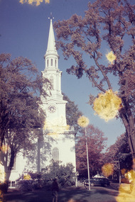
Slide, Robin Boyd, 1956-1957
Robin Boyd developed a close friendship with the founder of the Bauhaus in Weimar Germany, Walter Gropius, who had moved to the USA in the 1930s. Through this connection, Boyd was invited to be the Massachusetts Institute of Technology (MIT) Bemis Professor at the School in the North American academic year 1956-7. Robin and Patricia Boyd, with their youngest daughter Suzy, were based in Cambridge, Massachusetts for the year. Boyd gave some lectures at MIT and he was also invited to give lectures at many other universities, allowing him to travel widely within the USA, especially on the East Coast. This gave him the opportunity to meet architects like Frank Lloyd Wright, Eero Saarinen, Paul Rudolph and many others, and visit the offices of Skidmore, Owings and Merrill, and places like Taliesin and the General Motors Technical Center Detroit. On the way home, the Boyds visited London, Berlin, Paris and Le Corbusier’s Ronchamp Chapel in France.Colour slide in a mount. First Parish in Lexington, MAMade in USA / Patentedmit bemis professorship, mit, robin boyd, lexington, slide -
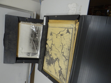 Brimbank City Council
2 x Black Folios
Old parish maps and photographs in two black folios. -
Stawell Historical Society Inc
Map, Parish of Stawell, North Ward & Big Hill etc
Shows Newington Co, Moonlight Co, St George Co, Victoria Co, Galatea Co Shows Tramline over Big Hill, Leviathan Co, Parish of Stawell, North Ward & Big Hill etcstawell -
 Bendigo Historical Society Inc.
Map - BOROUGH OF EAGLEHAWK SHEET 2, 9/12/1902
Map: Borough of Eaglehawk, sheet No. 2. Parish planmap, bendigo, parish plan, borough of eaglehawk -
 Bendigo Historical Society Inc.
Map - BOROUGH OF EAGLEHAWK SHEET 2, 9/12/1902
Map: Borough of Eaglehawk, Sheet No, 2. Parish planmap, bendigo, parish plan, borough of eaglehawk -
 Bendigo Historical Society Inc.
Map - BOROUGH OF EAGLEHAWK SHEET 3, Circa 1880's
Map: Borough of Eaglehawk , sheet No. 3. Parish planmap, bendigo, parish plan, `borough of eaglhawk -
 Bendigo Historical Society Inc.
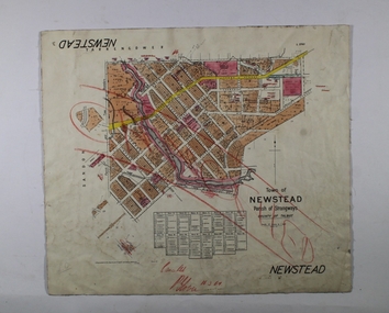
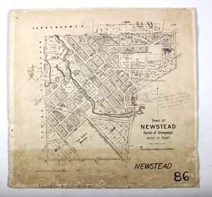
Map - NEWSTEAD, 1/11/1939
Map: Town of Newstead, Parish of Strangways, County of Talbotmap, talbot, township, newstead, parish of strangways, county of talbot -
 Bendigo Historical Society Inc.
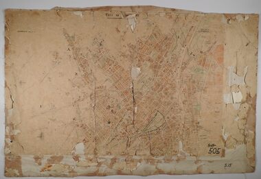
Map - SANDHURST SHEETS 1 AND 2, No date visible
Map: Sandhurst sheets 1 and 2. Parish planmap, bendigo, parish plan, sandhurst -
 Bendigo Historical Society Inc.
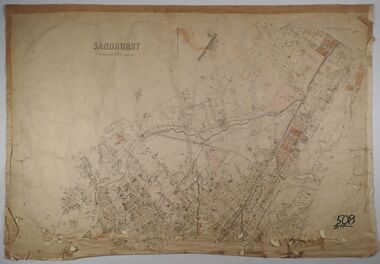
Map - SANDHURST, No date Visible
Map: Parish plan showing the Northern section of the Municipalitymap, bendigo, parish plan, sandhurst -
 Bendigo Historical Society Inc.
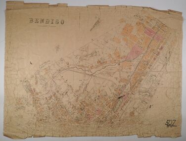
Map - BENDIGO, No date visible
Map: Parish plan showing the Northern section of the Municipalitymap, bendigo, parish plan, bendigo -
 Bendigo Historical Society Inc.
Map - NEWSTEAD, 15/10/1912
Map: Town of Newstead, Parish of Strangways, County of Talbotmap, talbot, township, newstead, county of talbot -
Stawell Historical Society Inc
Map, Township of Crowlands, Parish of Crowlands, County of Kara Kara, 1857
Township of Crowlands, Parish of Crowlands, County of Kara Kara stawell -
 Ringwood and District Historical Society
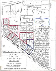
Map, The East Estate, Township of Ringwood, Victoria - 1927
Photocopied page - partial Parish map of Ringwood labeled The East Estate, showing street names and properties marked with names of individual owners or businesses.Page titled The East Estate by 1927 Part of Township of Ringwood, Parish of Ringwood, County of Mornington, Scale: Four Chains to One Inch. L.F. East blocks are marked by red outline. J. Blood blocks are marked by blue outline. Other names include B.C. Hutchinson & Co., The Victorian Brick & Ornamental Tile Coy., Ltd., The Ringwood Brickmaking Coy., Ltd., R. Davidson, J. Williamson, W.E. Bower, H. Jennings, G.J. Sims, J. Smallman, J. Horne, J. Lindsay, J. Kay, H. Unverhan, B.C. Hutchinson, M.A. Williamson, J.S. Woodworth, J. Price, C. Medew, S.W. Burchett, B.J. Hosking, D.J. Rogers, C. Wheeler, H. Frost, G.G. Miller, L. Winchcombe. Streets include Dublin Road, Illoura Road, Alexandra Road, and Bedford Road. -
![Map, [Coornmill land area available for leasing for grazing, Parish of Coornmill]. Circa 1904](/media/collectors/5e461d8021ea67224c82f2a1/items/677cde147f2053f3e5d277c3/item-media/677cdeea7f2053f3e5d27bb4/item-fit-380x285.jpg) Bacchus Marsh & District Historical Society
Bacchus Marsh & District Historical SocietyMap, [Coornmill land area available for leasing for grazing, Parish of Coornmill]. Circa 1904
This map shows an area of land north of Bacchus Marsh in the Larderderg State Park area known as the Parish of Coornmill.The map indicates an area of land which was to be made available by public tender for grazing leaseholders. The plan to do this was discussed in the Bacchus Marsh Express newspaper on the 16 July, 1904, page 2, column 7. The area reserved for grazing leases is identified by red lines on the map. The Express described the area available for grazing was 12,000 acres.A single page paper map showing an area of land in the Parish of Corrnmill to be made available for grazing leases. A photo lithographed Lands Department Map. No scale indicated. The map is pasted into a bound volume containing 76 maps or plans in total. High resolution digital image stored on BMDHS computer network. coornmill parish maps, lerderderg state park maps, agriculture bacchus marsh area -
Bendigo Historical Society Inc.
Map - LEICHARDT, 23/05/1875
Map: Parish of Leichardt, County of Bendigo. Parish plan (coloured). Attached plan in the top left hand corner marked 'Building Lots' (number 323 in map cupboard 1)map, bendigo, building lots, leichardt -
 Ringwood and District Historical Society
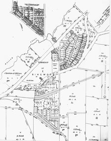
Photograph, Parish Map - Township of Ringwood - 1890
Written on backing sheet, 'SLV Parish Map Collection. Vol.67, Fol. 43, 1890'. Catalogue card reads, 'SLV Parish Map Collection 1890. (Township of Ringwood). -
 Ringwood and District Historical Society
Photograph, Circa 1855 Parish Map including Bulleen, Nunawading, and eventual site of Ringwood below blocks 23 & 24
Catalogue card reads, "C1858 Parish Map - Nunawading, Ringwood & Scoresby". -
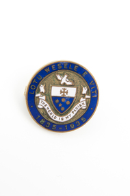 Uniting Church Archives - Synod of Victoria
Badge
Blue and white enamel badge commemorating the centenary of the Wesleyan church in Fiji"THE WORLD IS MY PARISH" "LOTU WESELE E VITI" "1835-1935"methodist church -
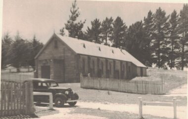 Linton and District Historical Society Inc
Photograph, The Parish Hall, Linton, 1937
Black and white photograph which has been printed as a postcard. Photograph shows a car in front of the Church of England Hall in Linton. An inscription on the back of the postcard gives the date as 1937 and also says that the car was owned by T. Nelson (probably Theo Nelson).On back of postcard: "Parish Hall / Linton / 1937 / T. Nelson's car".st paul's church of england linton, parish hall -
Glenelg Shire Council Cultural Collection
Photograph - Photograph - Sacred Heart Parish Church Casterton, c. 1963
SOURCED FROM CASTERTON TOWN HALL (FORMER SHIRE OF GLENELG) Sourced from Casterton Town Hall (Former Shire of Glenelg)Black and white photo, Sacred Heart Parish Church, CastertonBack: Black stamp '003826' -
Glenelg Shire Council Cultural Collection
Photograph - Photograph - Casterton, Victoria, c. 1963
SOURCED FROM CASTERTON TOWN HALL (FORMER SHIRE OF GLENELGBlack and white photo, Sacred Heart Parish Church, Casterton.Back: Black stamp '063826'tourism, postcard, photography -
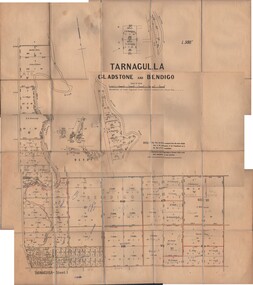 Bendigo Historical Society Inc.
Map - JACK FLYNN COLLECTION: TARNAGULLA SHEET 1, No date visible
Map: Parish of Tarnagulla Sheet 1, Counties of Gladstone and Bendigo.map, gladstone, parish plan, tarnagulla sheet 1 -
Bendigo Historical Society Inc.
Map - CITY OF SANDHURST RESURVEY SHEET NO. 3, 13/05/1881
Map: City of Sandhurst Resurvey sheet No. 3. Parish plan.map, bendigo, parish plan, sandhurst, resurvey -
Stawell Historical Society Inc
Map, Parish of Stawell, County of Borung, Stawell Township, Sheet 1, 1879
Parish of Stawell, County of Borung, Stawell Township, Sheet 1stawell