Showing 314 items matching "parks and environment"
-
 Glen Eira Historical Society
Album - Photograph Album, Beauville Estate Album, 2001
Originally labelled "Beauville Estate, Established 1936, Still Thriving 65 years on, 10th March 2001", the Beauville Estate Album contains colour photographs of houses in the Estate. They were taken around the time of the Beauville Estate’s 65th Heritage Celebration held on 10/03/2001 and donated to the Caulfield Historical Society shortly afterwards. Photographer Bev Baxter. Glen Eira’s Heritage Management Plan by Andrew Ward (1996) Vol 2 p78 states that by the end of 1934, the first 3 houses had been built in this housing estate.City of Glen Eira’s Heritage Management Plan Vol 2 p79 (p84 of the pdf version) – HO12 Beauville Estate and environs, Murrumbeena: The Beauville Historic Area is important at the State level as the first large housing estate undertaken by the AV Jennings Construction Co, later Jennings Group Limited, Victoria’s largest home builder. It is important also as a very early estate development incorporating a range of features other than houses and including made roads, shops and recreation facilities. In this respect it was the forerunner of the comprehensively planned housing estate of the post war era. The estate is distinguished by its aesthetic values, as is the earlier and comparable Hillcrest Estate, which are formed by a combination of restrained diversity in house styles, with the exception of no. 30 in the emerging International style, and by a landscaped garden environment.Colour photographs of house exteriors, as well as parks and tennis courts on the Beauville Estate. murrumbeena, houses, beauville avenue, architectural styles, 1930's, inter war style, a.v. jennings, av jennings, jennings, brick houses, beauville estate, murrumbeena road, lindsay avenue, gloucester court, dalny road, a v jennings construction co, beauville estate heritage area, glen eira city council, architectural features, plans, shops, residential development, tennis courts, housing estates, builders, building regulations, local government, commercial development, history, maps, photographs, commercial establishments, jennings group limited, land subdivision, gardens, beauville historic area, sir albert victor jennings -
Lakes Entrance Historical Society
Book, Parks Victoria Compiler, MacLeod Morass & Jones Bay Draft Management Plan 2003, 2003
... Parks Victoria Compiler ...A draft plan for the startegies to manage the Macleod Morass and Jones Bay Wildlife reservesenvironment, fauna, natural resources, restoration, vegetation -
 Lakes Entrance Historical Society
Photograph, Lakes Post Newspaper, Nyerimilang Park Kalimna West Victori, 1/04/1995 12:00:00 AM
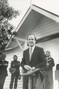
... Parks ...opening Gatehouse Shop at Nyerimilang Park Kalimna West Victoria. Nyerimilang Park under management of Parks Victoria, shop built and operated by Friends of Nyerimilang volunteersBlack and white photograph of Minister of Environment Mark Birrell parks, social history -
 Lakes Entrance Historical Society
Photograph, Lakes Post Newspaper, Victorian Coastal strategy draft plan for Eastern Beach Lakes Entrance Victoria, 1/12/1996 12:00:00 AM
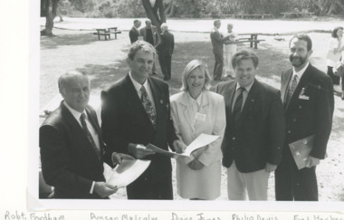
Black and white photograph of Robert Fordham,Chairman Vic Coastal Council, Duncan Malcolm, Diane James Acting Chairman Vic Coastal Council, Philip Davis Gippsland Province MLC, Fred Herbert Gippsland Coastal Council taken during launch of Victorian Coastal strategy draft plan for Eastern Beach taken in Lions Park Lakes Entrance Victoriacoast, environment, volunteering -
 Hymettus Cottage & Garden Ballarat
Work on paper - Bookmark
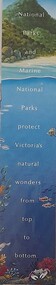
In a small populous state Victoria's National Parks are a vital link in Australia's network of National Parks and with large migrant intakes each year it is always vital to put these parks into the environment of these new residents and bookmark promotions through libraries and government agencies are an important way to do this.national parks, bookmarks -
 Wodonga & District Historical Society Inc
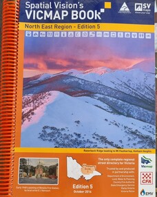
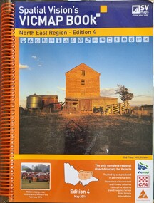
Book - Spatial Vision's VICMAP BOOK 2016 - Northeast Region, Spatial Vision Innovations Pty Ltd, 2016
This edition of Spatial Vision's VicMap Book North East Region was published in October 2016 and provides detailed topographic maps for the region. It was used by emergency services and various agencies, including the Country Fire Authority (CFA). It covers areas including Wodonga, Albury, Wangaratta, and beyond, including national parks and recreation areas. Text on the cover states that the volume is "Trusted by and produced in partnership with: Department of Environment, Land, Water & Planning, Country Fire Authority, State Emergency Service, Parks Victoria, Victoria Police".A spiral bound volume of 409 pages including colour topographic maps and illustrations of North East Victoria. The cover features a colour photo of Razorback Ridge leading to Mount Feathertop, Hotham Heights, Victoria. It also features an index map inside the front cover, a legend, road index, and locality index.This edition of Spatial Vision's VicMap Book North East Region was published in October 2016 and provides detailed topographic maps for the region. It was used by emergency services and various agencies, including the Country Fire Authority (CFA). It covers areas including Wodonga, Albury, Wangaratta, and beyond, including national parks and recreation areas. Text on the cover states that the volume is "Trusted by and produced in partnership with: Department of Environment, Land, Water & Planning, Country Fire Authority, State Emergency Service, Parks Victoria, Victoria Police".emergency management north east victoria, state emergency service, cfa wodonga -
 Wodonga & District Historical Society Inc
Book - Spatial Vision's VICMAP BOOK 2014 - North East Region
This edition of Spatial Vision's VicMap Book North East Region was published in May 2014 and provides detailed topographic maps for the region. It was used by emergency services and various agencies, including the Country Fire Authority (CFA). It covers areas including Wodonga, Albury, Wangaratta, and beyond, including national parks and recreation areas. Text on the cover states that the volume is "Trusted by and produced in partnership with: Department of Environment, Land, Water & Planning, Country Fire Authority, State Emergency Service, Parks Victoria, Victoria Police".A spiral bound volume of 409 pages including colour topographic maps and illustrations of North East Victoria. The cover features a colour photo of the old flour mill at Milawa, Victoria. It also features an index map inside the front cover, a legend, road index, and locality index.non-fictionThis edition of Spatial Vision's VicMap Book North East Region was published in May 2014 and provides detailed topographic maps for the region. It was used by emergency services and various agencies, including the Country Fire Authority (CFA). It covers areas including Wodonga, Albury, Wangaratta, and beyond, including national parks and recreation areas. Text on the cover states that the volume is "Trusted by and produced in partnership with: Department of Environment, Land, Water & Planning, Country Fire Authority, State Emergency Service, Parks Victoria, Victoria Police".emergency management north east victoria, cfa wodonga -
 Falls Creek Historical Society
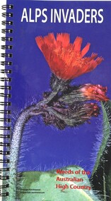
Book - Alps Invaders - Weeds of the Australian High Country, John Hosking, Geoff Sainty, Surrey Jacobs, 2006
The Australian Alps National Parks are relatively weed free compared with other environments that have been exploited by humans. By identifying weeds that pose the greatest threat to native vegetation, all users and visitors to these parks can assist park staff to locate weeds that require control. This identification guide has been produced for those concerned about weed invasions in these areas.A spiral volume of 62 pages including illustrations, a table of contents, map and index. The back cover includes logos of sponsors of the publication.The Australian Alps National Parks are relatively weed free compared with other environments that have been exploited by humans. By identifying weeds that pose the greatest threat to native vegetation, all users and visitors to these parks can assist park staff to locate weeds that require control. This identification guide has been produced for those concerned about weed invasions in these areas.alpine threats, australian environmental threats -
 Wooragee Landcare Group
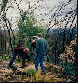
Photograph, 12th September 2004 or 15rh September 2004
This photograph was taken at Wooragee Landcare workshop (Quoll), field day in Mt Pilot park on Bush Recovery: After the Fires. This is part of the Biodiversity Month on September 2004. The Bush Recovery workshop was held on Sunday 12th September 2-4pm with Christine Watson, Sue Berwick and Natasha Schedvin, and another workshop on Wednesday, 15th September, 9am to 12 noon with local biologist Glen Johnson and botanists Gill Earl and Christine Watson. The topics involved in the training involved what species have returned, what species haven't, what recovery studies are being carried out, how are the barking owls and phascogales faring, and why is Mt Pilot important. The photograph shows L-R: Colin Payne; Jerry Alexander; Geoff Galbraith. Bush fires are common in Australia due to several reasons. One is due to the geographic spread of fire's seasons, secondly, the absence of El Nino conditions are also linked to fires. Climate change also affected Australia's hot and dry seasons. Australia's climate began warming since the 1970s. Human-induced fires also contributed to this increase in temperatures across the nation. Bush fires happened in Mt Pilot in 2003 but it has recovered well since. This makes Mt Pilot an important site to understand bushfire recovery. This photograph contributes to the scientific and historical records on bushfire recovery in Victoria. It creates a picture of Victorian community activities and efforts on biodiversity, climate change, and environmental care.Landscape coloured photograph printed on gloss paperReverse: WAN NA 0A2A0N0 NN2 0 163 / (No. 2)wooragee, wooragee landcare group, wooragee landcare, bush fires, bush recover, mt pilot, biodiversity month, botany, botanists, bush recovery, quoll, foxy, fox, forest, environment, climate change, bushfire recovery, bushfires, 2004 bushfire, field work, after the fires, fire, biodiversity -
Port Melbourne Historical & Preservation Society
Plan, Graeme Bentley Pty Ltd, Port Melbourne Foreshore Landscape Master Plan MP3 (A), February 1993
The Port Melbourne Foreshore Landscape Master Plan was created by Landscape Architectural firm of Graeme Bentley Pty Ltd for the City of Port Melbourne. MP3 (A) portrays the section of foreshore from Dow Street to Pickles Street. The plan proposed street tree planting along Beach Street and development of a park area opposite Johnson Street. The plan was not actioned.built environment - recreational facilities, beach street, port melbourne foreshore -
 Falls Creek Historical Society
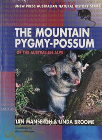
Book - The Mountain Pygmy Possum of the Australian Alps, Ian Mansergh & Linda Broome, 1994
The Mountain Pygmy possum or Burramys was known only from fossils until 1966, when the first living specimen was found hiding among fire wood at the University Ski Lodge on Mt Higginbotham, Victoria. The story of this species is a case study in conservation and ecology. Coming back from extinction, this tiny species is the only mammal restricted to the Australian Alps. It is found in Kosciusko National Park (NSW), and between Mt Bogong, Mt Higginbotham and at Mt Buller in Victoria. After years of patient research, the authors describe in this book everything that is known about the Burramys, from its physiology, mating habits and behaviour to how we can best manage and protect its habitat from human activities in the ski fields.A volume of 114 pages including 4 pages of coloured plates, maps and Illustrations by Katrina Sandiford. It was aimed at secondary students studying the geography of Alpine regions.non-fictionThe Mountain Pygmy possum or Burramys was known only from fossils until 1966, when the first living specimen was found hiding among fire wood at the University Ski Lodge on Mt Higginbotham, Victoria. The story of this species is a case study in conservation and ecology. Coming back from extinction, this tiny species is the only mammal restricted to the Australian Alps. It is found in Kosciusko National Park (NSW), and between Mt Bogong, Mt Higginbotham and at Mt Buller in Victoria. After years of patient research, the authors describe in this book everything that is known about the Burramys, from its physiology, mating habits and behaviour to how we can best manage and protect its habitat from human activities in the ski fields.environment victoria, australian endangered species, mountain pygmy possum -
 Falls Creek Historical Society
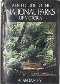
Book - A Field Guide to the National Parks of Victoria, Alan Fairley, January 1, 1982
... A Field Guide to the National Parks of Victoria ...This book serves as a comprehensive guide to reserves managed by the National Parks Service in Victoria, covering various aspects like history, geology, flora, fauna, and recreational activities. It divides Victoria into several parts, each with dedicated chapters for national parks, including detailed maps and entry points. Other reserves like State and coastal parks are grouped in a separate chapter. The content spans the diverse landscapes of Victoria, from Lower Glenelg to Burrowa Pine Mountain and the Alps to the desert, describing various types of soil, vegetation, animals, and natural beauty. It is intended for individuals who appreciate the outdoors, conservation, and bushwalking in the Australian bush.A volume of 363 pages 363 pages including 32 colour photos as well as illustrations and maps. It also includes a detailed index and bibliography. This book serves as a comprehensive guide to reserves managed by the National Parks Service in Victoria, covering various aspects like history, geology, flora, fauna, and recreational activities. It divides Victoria into several parts, each with dedicated chapters for national parks, including detailed maps and entry points. Other reserves like State and coastal parks are grouped in a separate chapter. The content spans the diverse landscapes of Victoria, from Lower Glenelg to Burrowa Pine Mountain and the Alps to the desert, describing various types of soil, vegetation, animals, and natural beauty. It is intended for individuals who appreciate the outdoors, conservation, and bushwalking in the Australian bush.national parks and reserves, environment victoria, national parks victoria guide -
Port Melbourne Historical & Preservation Society
Document, Rob YOUL et al, Notes and other material on the coal gas industry and Gasworks Park, July 2024
The spiral bound copy of the notes and photographs and story of the coal/gas industry and Gasworks Park was assembled by Rob YOUL and Judy Solomon between 2020 and 2024. gasworks park, built environment - industrial, industry gas & coal -
Port Melbourne Historical & Preservation Society
Book, "My Port Melbourne" Photographic competition July 2016, 25 Jul 2016
Made by John KIRBY and Margaret BRIDE from entries to "My Port Melbourne" photographic competition for July 25 2016 PMHPS general meeting."My Port Melbourne" Photographic competition July 2016. Blue folder with thumbnail photos on cover of the photographs inside. Index page of entrants and subjects followed by pages of text and accompanying image of images.built environment - civic, built environment - domestic, parks and gardens, west gate bridge, religion - roman catholic church (st josephs), war - world war ii, education - primary schools, workers, sport - cricket, barbara gardiner nee hegarty, ben piper, bernie mcphee, carmel pascolo, christine griffiths, david nicolas, david thompson, george tsingos, glen cosham, graham bride, helen barry, janet bolitho, jill dawson, jim power, john kirby, john may, joy phillips, margaret bride, natalie kobica, robyn blackmore, sue kidd, sue leong, suzy milburn, edward walter (ted) raven