Showing 10928 items matching "plan"
-
 Federation University Historical Collection
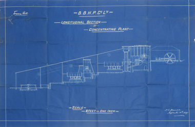
Plan, Blueprint B.B.H.P. Co Ltd Longitudinal Section of Concentrating Plant, 1895
Blueprint plan by H.L. Hancock blueprint, h. l. hancock, longitudinal section, concentrating plant, bhp -
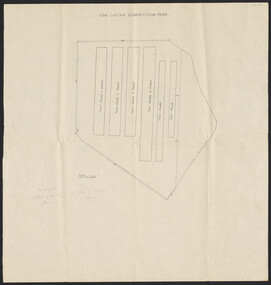
 Clunes Museum
Plan, Varley Bros, Proposed Turbine Creamery, 1894
Hand drawn plan on paperHandwritten in black ink: "These are the drawings referred to in our tender dated 7th September '94 for erection of creamery building at Glendaruel J Acrow *& Co. Contractorcreamery, turbines, plans, glendaruel, j bartram & son, varley bros -
Port Melbourne Historical & Preservation Society
Plan, Graeme Bentley Pty Ltd, Port Melbourne Foreshore Landscape Master Plan MP3 (A), February 1993
The Port Melbourne Foreshore Landscape Master Plan was created by Landscape Architectural firm of Graeme Bentley Pty Ltd for the City of Port Melbourne. MP3 (A) portrays the section of foreshore from Dow Street to Pickles Street. The plan proposed street tree planting along Beach Street and development of a park area opposite Johnson Street. The plan was not actioned.built environment - recreational facilities, beach street, port melbourne foreshore -
Port Melbourne Historical & Preservation Society
Plan, Graeme Bentley Pty Ltd, Port Melbourne Foreshore Landscape Master Plan MP1(A), February 1993
The Port Melbourne Foreshore Landscape Master Plan was created by Landscape Architectural firm of Graeme Bentley Pty Ltd for the City of Port Melbourne. MP1(A) portrays the section of foreshore from the former Port Melbourne Railway Station to Bay Street. The plan proposed extensive tree planting including Tasmanian native trees along Station Pier. The plan was not actioned.built environment - recreational facilities, beach street, port melbourne foreshore, station pier -
 Federation University Historical Collection
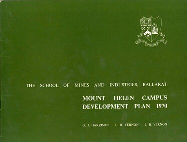
Book, Mount Helen campus Development Plan 1970, 1970
Green and white soft covered booklet of 48 pages. SMB Crest is on the front cover. The content include the Mt Helen site, site planning, student residences, sporting facilities, roads and parking, pedestrian circulation, engineering services, and landscaping. Illustrations include: Plan of Mt Helen Site (July 1969, existing buildings, Functional relationship, Roads and Parking, Pedestrian Circulation, engineering Services, Landscaping, Development Plan, Plan of Academic area, Library and union Courtyards, Birds Eye View of Academic Area from north-west, etc. the master plan projects student numbers.non-fictionuniversity of ballarat, ballarat institute of advanced education, mount helen, master plan, landscape, harrison, vernon, great hall, geoff harrison, john vernon, m.b. john, contour map, student accomodation, landscaping, development plan, campus plan -
 Kew Historical Society Inc
Plan - Subdivision Plan, Plan of Subdivision of Crown Portion 71, Parish of Boroondara LP12509, Vol.1678, Fol.335526, Before 1930
Prue Sanderson, in her groundbreaking ‘City of Kew Urban Conservation Study : Volume 2 - Development History’ (1988), summarised the periods of urban development and subdivisions of land in Kew. The periods that she identified included 1845-1880, 1880-1893, 1893-1921, 1921-1933, 1933-1943, and Post-War Development. These periods were selected as they represented periods of rapid growth or decline in urban development. An obvious starting point for Sanderson’s groupings involved population growth and the associated economic cycles. These cycles also highlighted urban expansion onto land that was predominantly rural, although in other cases it represented the decline and breakup of large estates. A number of the plans in the Kew Historical Society’s collection can also be found in other collections, such as those of the State Library of Victoria and the Boroondara Library Service. A number are however unique to the collection.Subdivision plans are historically important documents used as evidence of the growth of suburbs in Australia. They frequently provide information about when the land was sold on which a built structure was subsequently constructed as well as evidence relating to surveyors and real estate and financial agents. The numerous subdivision plans in the Kew Historical Society's collection represent working documents, ranging from the initial sketches made in planning a subdivision to printed plans on which auctioneers or agents listed the prices for which individual lots were sold. In a number of cases, the reverse of a subdivision plan in the collection includes a photograph of a house that was also for sale by the agent. These photographs provide significant heritage information relating house design and decoration, fencing and household gardens.The six lots on the south side of Macartney Avenue, between Macartney Avenue and Daniell Place were part of a subdivision that occurred before 1930. The subdivision plan is of interest in that the original name of Daniell Place was Brougham Place. On the Plan, it is noted that lots 5 and 6 (currently 10 and 12 Macartney Avenue) had been sold for £13 each. By November 1930, the new six-roomed villa built on 12 Macartney Avenue was offered for immediate sale at a ‘sacrifice price’. Any offer in reason would be considered, although a £350 deposit was required.subdivision plans - kew, mount street - kew, brougham street - kew , macartney avenue - kew -
 Flagstaff Hill Maritime Museum and Village
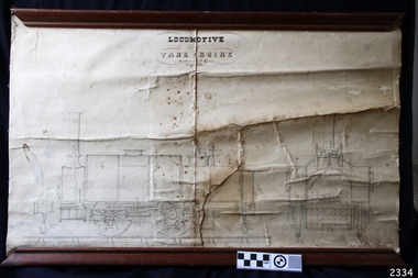
Plan
Plan of locomotive tank engine drawn by A. Kerr 1852. This plan is attached to canvas, and has wooden rails, top and bottom.flagstaff hill, warrnambool, shipwrecked-coast, flagstaff-hill, flagstaff-hill-maritime-museum, maritime-museum, shipwreck-coast, flagstaff-hill-maritime-village, locomotive tank engine, a. kerr -
University of Melbourne, Burnley Campus Archives
Plan, Concept Plan, Cross-Section Elevation, c. 1990
Plans for 2 different gardens by Amanda McLaurin (student). Scale 1:50.amanda mclaurin, concept plans, home garden design -
University of Melbourne, Burnley Campus Archives
Plan, Nick Moore, Landscape Plan 12 Tyne Street Final Design Assignment, 2005
Coloured plan by Nick Moore dated June 2005. Scale 1:100.nick moore, landscape design -
University of Melbourne, Burnley Campus Archives
Plan - Planting plan, 1993
Tracing paper plan by Lisa McKern, dated 11.11.1993. Scale 1:100.lisa mckern, planting plan -
University of Melbourne, Burnley Campus Archives
Plan (Item) - Coloured plan, laminated, Sewerage & Water Plan
-
Federation University Historical Collection
Booklet, Michael Taffe, Beaufort House Ballarat Conservation Plan, 2004
Michael Taffe undertook this Conservation Pan while completing an Bachelor of Arts (Honours) at the University of Melbourne in 2004.Forty five page conservation management plan for Beaufort House. Includes: * Dowling Forest Paris Plan * Plan of Drainagebeaufort house, student residences, student accomodation, certificate of title, dowling forest, henry cuthbert, archibald mckay, max mckay, beaufort street, cardigan street, stables, charles davernport cuthbert -
 University of Melbourne, Burnley Campus Archives
Plan, Horticultural Society of Victoria Plan of Gardens, Richmond, 1865
Plan on linen-backed paper of Burnley Gardens showing Yarra River, Swan St., railway, plan of west orchard and old garden sketched by hand in pencil. Inscription, "Presented to the Society, by A. Purchas C.E." Shows acreagesInscription, "Presented to the Society, by A. Purchas C.E." Oct 4th 1865"gardens, richmond, a. purchas, horticultural society of victoria -
University of Melbourne, Burnley Campus Archives
Plan, Horticultural Project Conservation and Management Plan Wombat Park, 1994
Photocopies of plan drawn by M. Gilbert of Survey Area C-G, with numbered plant list. (Miffy Gilbert's final thesis, 1994, Conservation Analysis & Management Plan Wombat Park Daylesford - see AGHS website)m. gilbert, wombat park, management plan, daylesford, gardens, plant list -
Lakes Entrance Historical Society
Book, Crocker Robyn and Associates, Gippsland Boating Coastal Action Plan, 2002
This action plan provides for an integrated approach to coastal planning in Gippsland.waterways, environment, tourism -
University of Melbourne, Burnley Campus Archives
Plan, Site plan 48 Barnard Grove Kew, 1995-1998
(1) Set of drawings - Folio 1995 by Meghan Bate includes Preliminary Plan 48 Barnard Grove Kew dated 1.6.95. (2) Tracing paper Site Plan. Scale 1:100. Unnamed. (3) Photocopy of Preliminary Plan of 'Hill Residence 48 Barnard Grove Kew' by Joanna Cutter, p3 of 4, dated 01.06.1998. Scale 1:100.kew, joanna cutter, meghan bate -
 University of Melbourne, Burnley Campus Archives
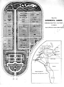
Plan - Photocopies and photograph, Plan of the Experimental Gardens, c. 1860
See B92.0633experimental, gardens, alfred lynch, plan -
 Kew Historical Society Inc
Map, MMBW, MMBW Plan No.39 Kew & Heidelberg, 1900-1910
The Melbourne and Metropolitan Board of Works (MMBW) was established by an act of the Victorian Parliament in 1890 to prepare for and to implement a sewerage and water reticulation system across what was then inner Melbourne, its surrounding and middle distance suburbs, including Kew. The MMBW was disbanded in 1991.The map collection of the Kew Historical Society has at its core the historic maps assembled and originally stored in the City Engineer's Department of the City of Kew. These include maps in a number of scales. The vast majority of maps were produced by the MMBW in the first two decades of the twentieth century, and are solid working maps, backed by linen for durability. These maps are historically significant to Kew, the City of Boroondara and to the history of the development of state utilities in Victoria. A number of the Kew maps have additional details added by former municipal officers, including the levels reached by various floods. As these were working documents, information was added to them long after the period of their initial production and distribution.Early map of part of the Borough of Kew, created in the first decade of the twentieth century, at a scale 160 ft to 1 inch. The map covers what was then the north western section of Kew, bordered on its north by Wills Street and the Kew Lunatic Asylum, in the west by the River Yarra [and the later added Yarra Boulevard] , by Princess Street in the East and Holroyd Street in the south. The map shows the extent of urban development by that time, prominent institutions and the outlines of built structures in the municipality. Contour lines were added in ink to the map at a later stage.MELBOURNE AND METROPOLITAN BOARD OF WORKS / PLAN NO. 39 / KEW & HEIDELBERGmelbourne & metropolitan board of works, mmbw maps, mmbw plans, borough of kew, cartography -
 Kew Historical Society Inc
Map, MMBW, MMBW Plan No.40 Collingwood & Kew, 1900-1910
The Melbourne and Metropolitan Board of Works (MMBW) was established by an act of the Victorian Parliament in 1890 to prepare for and to implement a sewerage and water reticulation system across what was then inner Melbourne, its surrounding and middle distance suburbs, including Kew. The MMBW was disbanded in 1991.The map collection of the Kew Historical Society has at its core the historic maps assembled and originally stored in the City Engineer's Department of the City of Kew. These include maps in a number of scales. The vast majority of maps were produced by the MMBW in the first two decades of the twentieth century, and are solid working maps, backed by linen for durability. These maps are historically significant to Kew, the City of Boroondara and to the history of the development of state utilities in Victoria. A number of the Kew maps have additional details added by former municipal officers, including the levels reached by various floods. As these were working documents, information was added to them long after the period of their initial production and distribution.Early map of part of the Borough of Kew, created in the first decade of the twentieth century, at a scale 160 ft to 1 inch. The map covers what was then the south western section of Kew, bordered on its north by Studley Park Road, in the west by Walmer Street and the River Yarra, by High Street South and Princess Street in the East and Barkers Road in the south. The map shows the extent of urban development by that time, prominent institutions and the outlines of built structures in the municipality. Contour lines and historic flood levels were added in ink to the map at a later stage.MELBOURNE AND METROPOLITAN BOARD OF WORKS / PLAN NO. 40 / COLLINGWOOD & KEWmelbourne & metropolitan board of works, mmbw maps, mmbw plans, borough of kew, cartography -
 Kew Historical Society Inc
Map, MMBW, MMBW Plan No.64 Kew & Heidelberg, 1900-1910
The Melbourne and Metropolitan Board of Works (MMBW) was established by an act of the Victorian Parliament in 1890 to prepare for and to implement a sewerage and water reticulation system across what was then inner Melbourne, its surrounding and middle distance suburbs, including Kew. The MMBW was disbanded in 1991.The map collection of the Kew Historical Society has at its core the historic maps assembled and originally stored in the City Engineer's Department of the City of Kew. These include maps in a number of scales. The vast majority of maps were produced by the MMBW in the first two decades of the twentieth century, and are solid working maps, backed by linen for durability. These maps are historically significant to Kew, the City of Boroondara and to the history of the development of state utilities in Victoria. A number of the Kew maps have additional details added by former municipal officers, including the levels reached by various floods. As these were working documents, information was added to them long after the period of their initial production and distribution.Early map of part of the Borough of Kew, created in the first decade of the twentieth century, at a scale 160 ft to 1 inch. The map covers what was then the northern most part of Kew, bordered on its north and west by the Yarra River, in the East by Connor's Creek and by the Asylum in the south. The map shows the extent of urban development by that time, prominent institutions and the outlines of built structures in the municipality. Contour lines and historic flood levels were added in ink to the map at a later stage.MELBOURNE AND METROPOLITAN BOARD OF WORKS / PLAN NO. 64 / KEW & HEIDELBERGmelbourne & metropolitan board of works, mmbw maps, mmbw plans, borough of kew, cartography -
 Kew Historical Society Inc
Map, MMBW, MMBW Plan No.65 Kew & Heidelberg, 1900-1910
The Melbourne and Metropolitan Board of Works (MMBW) was established by an act of the Victorian Parliament in 1890 to prepare for and to implement a sewerage and water reticulation system across what was then inner Melbourne, its surrounding and middle distance suburbs, including Kew. The MMBW was disbanded in 1991.The map collection of the Kew Historical Society has at its core the historic maps assembled and originally stored in the City Engineer's Department of the City of Kew. These include maps in a number of scales. The vast majority of maps were produced by the MMBW in the first two decades of the twentieth century, and are solid working maps, backed by linen for durability. These maps are historically significant to Kew, the City of Boroondara and to the history of the development of state utilities in Victoria. A number of the Kew maps have additional details added by former municipal officers, including the levels reached by various floods. As these were working documents, information was added to them long after the period of their initial production and distribution.Early map of part of the Borough of Kew, created in the first decade of the twentieth century, at a scale 160 ft to 1 inch. The map covers what was then the south central part of Kew, bordered on its north by Malmsbury Street, in the west by Florence Avenue, in the south by Barkers Road, and in the east by Princess Street. The map shows the extent of urban development by that time, prominent institutions and the outlines of built structures in the municipality. Contour lines were added in ink to the map at a later stage.MELBOURNE AND METROPOLITAN BOARD OF WORKS / PLAN NO. 65 / KEW & HEIDELBERGmelbourne & metropolitan board of works, mmbw maps, mmbw plans, borough of kew, cartography -
 Kew Historical Society Inc
Map, MMBW, MMBW Plan No.117 Heidelberg & Kew, 1900-1910
The Melbourne and Metropolitan Board of Works (MMBW) was established by an act of the Victorian Parliament in 1890 to prepare for and to implement a sewerage and water reticulation system across what was then inner Melbourne, its surrounding and middle distance suburbs, including Kew. The MMBW was disbanded in 1991.The map collection of the Kew Historical Society has at its core the historic maps assembled and originally stored in the City Engineer's Department of the City of Kew. These include maps in a number of scales. The vast majority of maps were produced by the MMBW in the first two decades of the twentieth century, and are solid working maps, backed by linen for durability. These maps are historically significant to Kew, the City of Boroondara and to the history of the development of state utilities in Victoria. A number of the Kew maps have additional details added by former municipal officers, including the levels reached by various floods. As these were working documents, information was added to them long after the period of their initial production and distribution.Early map of part of the Borough of Kew, created in the early twentieth century, at a scale 160 ft to 1 inch. The map covers what was then the north eastern part of Kew showing the natural landscape and limited development on the south side of the Yarra River. In the Kew section, south of the river, the land is occupied currently by the Greenacres and Kew Golf Clubs. The map shows the extent of urban development by that time and the outlines of the few built structures in the municipality. The height above sea level of all parts of the landscape are indicated numerically in feet. Contour lines and the levels of historic floods were added in ink to the map at a later stage. MELBOURNE AND METROPOLITAN BOARD OF WORKS / PLAN NO. 117 / HEIDELBERG & KEW melbourne & metropolitan board of works, mmbw maps, borough of kew, cartography, mmbw plan no. 117, kew (vic.) -- maps, heidelberg (vic.) -- maps -
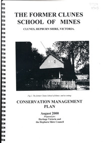 Federation University Historical Collection
Book, The Former School of Mines Clunes Conservation Management Plan, 2000, 08/2000
The Clunes School of Mines was a campus of the Ballarat School of Mines. The conservation plan was prepared for Hepburn Shire Council and Heritage Victoria to guide the future management of the former Clunes School of Mines in Service Street, Clunes, The building was opened in February 1892 as the Clunes branch of the Ballarat School of Mines, and ceased operating in June 1893.Spiral bound black and white copy of the Conservation Plan for the Clunes School of Mines. Contents include the history, chronology development, context of the building and site, current and past function of the building, original fabric, impact of later alterations, condition of the building, statement of significance, conservation action plan, caring for the site, collecting and keeping information, structural engineers Report, Department of Lands Survey 1955, Memorandum of Agreement 1956.ballarat school of mines, clunes school of mines, australian native association, ana, australian native association clunes branch, eygelaar inner spring mattress factory, clunes infant welfare centre, clunes angling club -
 Federation University Historical Collection
Plan, Proposed Additions to the Ballarat Gaol Gates
The Ballarat Gaol was closed in 1967, and became a part of the Ballarat School of Mines (now Federation University SMB Campus)Copies of plans of the gates a the Ballarat Gaol.ballarat gaol gates, plans, ballarat school of mines, ballarat gaol -
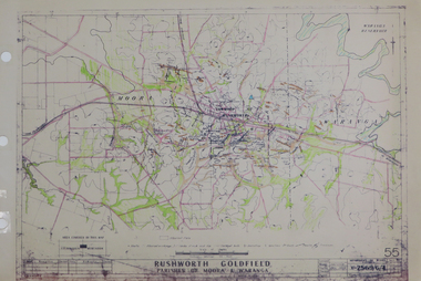 Federation University Historical Collection
Plan, Rushworth Goldfield: Parishes of Moora and Waranga, pre 1954
Printed plan on paper with hand colouringrushworth, moora, waranga -
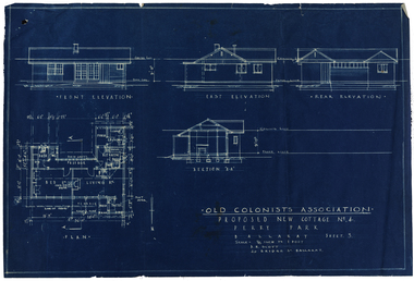 Old Colonists' Association of Ballarat Inc.
Plan, Old Colonists' Association Proposed New Cottages No. 4, Sheet 5, c1925
Blueline plan of the Old Colonists' Association. old colonists' association ballarat, charles anderson grove, retirement village, old colonists' association ballarat cottages -
University of Melbourne, Burnley Campus Archives
Plan, Michael Green, 46 Young Street Kew Garden Concept Plan, 2000
Tracing paper plan by Michael Green dated December 2000. Scale 1:50michael green, gardens, kew -
University of Melbourne, Burnley Campus Archives
Plan, "Invergowrie" Tree Survey Plan, 1989
Dyeline plan drawn by W. Klein. Numbered trees with position in garden. Dated 03.03.1989.invergowrie, w. klein -
 University of Melbourne, Burnley Campus Archives
Plan, Egg Laying Competition Pens, c. 1957
Plan of layout of the fowl sheds and coops.Handwritten on plan ,"on original 1. plan of existing fence. 2. plan of proposed fence." sheds, coops, egg laying, competitions -
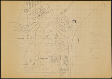 University of Melbourne, Burnley Campus Archives
Plan, Victorian College of Agriculture and Horticulture - Burnley Site Plan, 1986
Given to Archives by Jim Galea (Staff 1985-87).Prints and paper copies of plan of Burnley Campus by Fresco Color Group No 60 337-A dated February 1986. Scale 1:500. (1) 3 prints of the plan, 1 small, 2 larger (1 with legend and grid). (2) Tracing paper copy, no legend, no grid. (3) Paper copy, legend and grid, of Ornamental Garden Area. (4) "Drawing Orchard Site Plan," grid and legend printed, the rest hand drawn. (5) Film and paper copies without grid and legend. N.B. 11.0716, Further development of Plan. vcah, burnley, fresco color group, orchard, burnley gardens