Showing 659 items
matching plan of survey
-
 Federation University Historical Collection
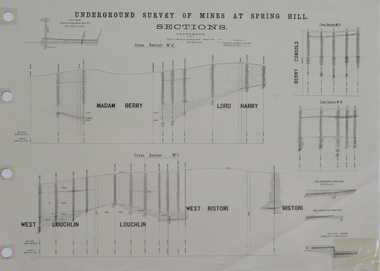
Plan, Underground Survey of Mines at Spring Hill Cross Section No 2, 1886
Plan printed by the Government Printing Office Melbourne, of underground survey at Spring Hill.underground survey, spring hill, steam litho government printing office -
 Federation University Historical Collection
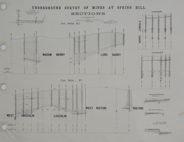
Plan, Underground Survey of Mines at Spring Hill Cross Section No 2, 1886
Plan printed by the Government Printing Office Melbourne, of underground survey at Spring Hill.underground survey, spring hill, steam litho government printing office -
 Federation University Historical Collection
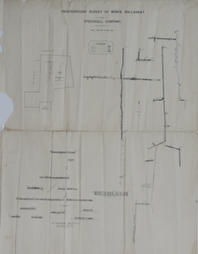
Plan, Underground Survey of Mines, Ballaarat, not dated
... of the Speedwell Company. Underground Survey of Mines, Ballaarat Plan Plan ...Printed transverse section of the Speedwell Company.underground survey, speedwell company -
 Federation University Historical Collection
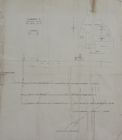
Plan, Llanberris Co. Transverse Section, not dated
Printed transverse section of the Llanberris Companyunderground survey, llanberris mine, llanberris co, ballarat -
 Federation University Historical Collection
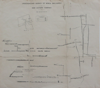
Plan, Underground Survey of Mines Ballaarat, New Victoria Company, not dated
Printed transverse section of the New Victoria Company.underground survey, new victoria company, transverse section, mining, plan -
 Federation University Historical Collection
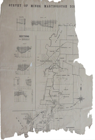
Plan, Survey of Mines, Maryborough District, not dated
... Survey of Mines, Maryborough District Plan Plan ...Maryborough is a Central Victorian town. Printed section of the Maryborough Districtmaryborough, carisbrook, majorca, horizontal sections, vertical sections, chalk's no 4, east kong meng, craigie -
 Federation University Historical Collection
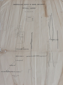
Plan, Underground Survey of Mines, Ballaarat, Britannia Company, not dated
Printed underground survey of the Britannia Companyunderground survey, britannia company, last chance company, transverse section -
 Federation University Historical Collection
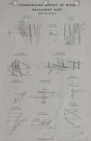
Plan, Underground Survey of Mines, Ballaarat East Sections, c1890
... underground survey ballaarat east mining Printed plan showing cross ...Printed plan showing cross sections of various mine shaftsplan, underground survey, ballaarat east, mining -
 Federation University Historical Collection
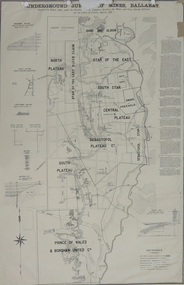
Plan, Underground Survey of Mines, Ballarat, 1887, 1887
... E.J. Barker Library (top floor) Mount Helen goldfields plan ...Printed plan with text down right side and black border, 4 holes top edge and repairsplan, underground survey, robert allen, w. langtree, prince of wales and bonshaw united, bonshaw, south plateau, north plateau, sebastopol plateau, sebastopol star, star of the east, south star, band and albion, owen's freehold, leigh river, yarrowee creek, robert allan, gay's freehold -
 Federation University Historical Collection
Report, Integrated Tourism Strategy Plan for the Goldfields Region of Victoria: Volume II: Appendices - Miscellaneous, 10/1995
Black plastic ring binding on an A4 report.goldfields of victoria, goldfields tourism, marketing, goldfields campaign, mining tourism, torusim, tourism strategy, ballarat, bendigo, avoca, maryborough, castlemaine, maldon, community survey -
Federation University Historical Collection
Report, Integrated Tourism Strategy Plan for the Goldfields Region of Victoria, 1994
Black ring binding on an A4 report.goldfields of victoria, goldfields tourism, marketing, goldfields campaign, mining tourism, torusim, tourism strategy, ballarat, bendigo, avoca, maryborough, castlemaine, maldon, community survey, michael pearlman, anastasia molloy, jack harvey, avoca -
Federation University Historical Collection
Report, Goldfields Regional Tourism Development Plan, c1997, 1997
White bound report with clear cover and black plastic ring bindinggoldfields of victoria, goldfields tourism, marketing, tourism, road transport, rail transportair transport, aboriginal cultural heritage, tourism victoria, surveys, applied tourism business project -
Federation University Historical Collection
Book, Jacobs Lewis Vines Architects and Conservation Planners, Historic Sites Survey: Ballarat Study Area, 1980, 1980
This survey was commissioned by the Land Conservation Council, Australian Heritage Commission and the Ministry for Conservation 114 page report on historic sites in the Ballarat region. It includes information on sites, a schexdule of sites, silte selection and designated areas (ie around towns)historic sites, ballarat, wendy jacobs, miles lewis, gary vines, berringa, buninyong, creswick, dunnstown, fiery creek, lal lal, langi logan, cathcart, mount cole, mount egerton, nerrina, gong gong, wombat state forest, railways, explorers routes, early roads, land conservation council, ausralian hertiage commission, department of planning, icomos (burra) charter, nigel lewis, richard aitken, freehold land, public land, langi ghiran, new jubille mine, birthday tunnel mine, pitfield plains, smythesdale, buninyong company, mount clear, mt clear, canadian gully, warrenheip distillery, thomas mitchell, waterloo, trawalla, beaufort, raglan, internment camps, forestry, mining, mining, mt egerton, mary hollick collection, jubilee mine, burra charter, historica areas data form, explorers, egerton company, black horse mine, mt egerton government battery, kaolin mines, anderson brothers, barkstead, anderson's tramway, clarkesdale, berry leads, birthday tunnel mine berringa, warrenheip, australasian company, mount mercer, lanvi-kal-kal, water race -
 Ringwood and District Historical Society
Newspaper, Scrapbook Clipping, Library Collection, Ringwood, Victoria, `
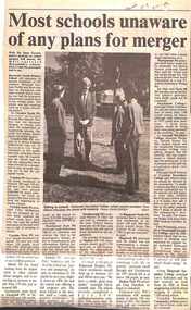
``Newspaper clipping from the "Mail" 5-11-96 P9. Most schools unaware of any plans for merger.Wih the State Government's position well known on school mergers, "The Mail" surveyed Maroondah's schools on the same subject. Most of the surveyed schools said they knew nothing of any planned mergers, or they did not wish to comment. No school said they were in favour of mergers in Maroondah. ` -
 Ringwood and District Historical Society
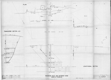
Plan - Department of Mines, Victoria, Ringwood Gold and Antimony Mine - 1921
Technical drawings of Antimony Mine - Plan view, Transverse Section view, and Longitudinal Section view. Includes Main Shaft, No.1 Level 184', No.2 Level 244', No.3 Level 304', No.4 Level 372'. Multiple copies, including copy with overlay of Civic Centre.Scale 40 feet to 1 inch. Surveyed 20-12-21. Traced 1-7-66. W-2568/B/1. -
 Ringwood and District Historical Society
Map, Plan of Country Lands in the Parishes of Nunawading Ringwood and Scoresby - circa 1855
Blueprint copy of Survey Map detailing original Selectors' names and property locations. List of Parish map references including property bearings, distances in Links, and markings on trees. Descriptive remarks include areas marked "Farmer's Common", "Poor soil thickly/moderately timbered with stringy bark", and location of water and firewood reserves."Surveyed and plotted by N.M. Bickford, Superintendant of Mr. Hodgkinson's Field Party". "The land comprised in this survey is of inferior quality, moderately undulating, and thickly wooded. It is watered by Dandenong Creek and Deep Creek." Inset map showing location of (*proposed) cemetery on southern corner of Lillydale Road from Melbourne and Sawmill Road, later Mount Dandenong Road. (*Cemetery did not eventuate.) -
 Ringwood and District Historical Society
Map, Plan of the Parish of Warrandyte County of Evelyn - 1841
Blueprint copy of Survey Map W27 detailing original Selectors' names and property locations between Yarra Yarra River (Warrandyte) and Mullum Mullum Creek (Ringwood). List of Parish map references including property bearings, distances in Links, and markings on trees. Pound Bend area of Warrandyte marked as Reserve For Aborigines. Descriptive remarks include areas marked "scrubby, flat, sandy soil". Several other references faded and illegible.(Map) by T.H. Nutt Feb 3 1841. -
 Ringwood and District Historical Society
Newspaper, Scrapbook Clipping, Library Collection, Ringwood, Victoria
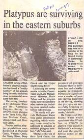
Newspaper Clipping from "The Post", 14 January 1997, Page 11, "Platypus are surviving in the eastern suburbs"'.A major survey of Melbourne's platypus population has found a "healthy number" of the animals living in creeks and rivers close to residential area in the outer east. Conservation and Land Management Minister, Marie Tehan, was present at the launching of the survey results, and spoke in detail about the results and the future planning and financial aid for the health of the Melbourne waterways. -
 City of Moorabbin Historical Society (Operating the Box Cottage Museum)
Buildings, Shingles Original Cottage c1850, c1850
The original small, pioneer cottage was built in the late 1840s to early1850s, by an unknown pioneer. It was located on part of a 30 Acre allotment that was originally part of Henry Dendy’s 'Special Survey Brighton' granted in 1841 (5120acres). There is a small display of external cladding shingles from the original pioneer cottage. Wooden shingles were usually thin (3⁄8 to 3⁄4 in or 10 to 19 mm), relatively narrow (3 to 8 in or 76 to 203 mm), of varying length (14 to 36 in or 360 to 910 mm), and almost always planed smooth. The traditional method for making wooden shingles was to rive - hand split - them from straight-grained knot-free sections of logs pre-cut to the desired length known as bolts. These bolts were quartered or split into wedges. A mallet and axe were used to split out thin pieces of wood. The wood species varied according to available local woods, but only the more durable inner section of the log was usually used. The softer sapwood generally was not used because it deteriorated quickly. Because hand-split shingles were somewhat irregular along the split surface, it was necessary to dress or plane the shingles to make them fit evenly on the roof. This reworking was necessary to provide a tight-fitting roof over typically open shingle lath or sheathing boards. These are the original shingles found on Box Cottage by L Lewis 1970 and used in the reconstruction in 19843 x wood Shingles used on roof of Box Cottage c 1850box cottage museum ormond, henry dendy special survey brighton 1841, brighton, moorabbin shire, parish of moorabbin, county of bourke,cottages, pioneers, ormond, colonial, mckinnon, dendy henry, box william, box elizabeth, reitman william, convicts, lewis timber co. ltd., deam h, museums, box alonzo, smith a, -
 City of Moorabbin Historical Society (Operating the Box Cottage Museum)
Photographs, x 4 Black & White, Whitmuir Hall / Killearnan / Bentleigh Club 1930, c1930
Whitmuir Hall was built 1850 using bricks hand -made from the clay of nearby Elster Creek. Early history of the 156 acre estate bounded by McKinnon, Centre, Thomas and Wheatley Roads is obscure. The gardens were laid out prior to 1850. Robert Gray Ford purchased 20 acres with mansion in 1872 for £ 1750 and it was valued at £ 25,000 in 1888 but sold after the Bank Crash 1890's for £ 5,000 in 1892. There were many owners over the years including Thomas Bent and in 1870 it was called 'Killearnan'. It is now is known as 'the Bentleigh Club and many original features have been restored and preserved . Whitmuir Hall, was a stately mansion built 1850 typical of the grandiose plans of successful early settlers. Stained glass Windows, furniture, imported from France and Italy have been preserved by the Bentleigh Club.4 of 13 Black & White photographs of Whitmuir Hall now Benleigh Club, Yawla St Bentleigh c 1930whitmuir hall, bentleigh club, killearnan, mansions, gold rush victoria, smith j l; smith mary ann, stanley helen, smith vic, smith harry redvers, chaff cutter, horse drawn carts, toll gates brighton, motor cars 1900, steam engines, early settlers, bentleigh, parish of moorabbin, city of moorabbin, county of bourke, moorabbin roads board, shire of moorabbin, henry dendy's special survey 1841, were j.b.; bent thomas, o'shannassy john, king richard, charman s, highett william, ormond francis, maynard -
 City of Moorabbin Historical Society (Operating the Box Cottage Museum)
Newsletter, City of Moorabbin Historical Society Jun 2010 pdf, June 2010
The City of Moorabbin Historical Society was formed c 1960 by a group of Moorabbin residents who were concerned that the history of the area should be preserved. A good response to a call for items related to the historical area of Moorabbin Shire brought donations of a wide variety of artefacts which are now preserved by the current members of CMHS at Box Cottage Museum . Helen Stanley, Secretary of CMHS, began producing a Newsletter for members in April 2007 to provide current information and well researched items of historical interest. Helen Stanley has produced a bi-monthly Newsletter, 2007 - 2013, for the members of the City of Moorabbin Historical Society that contains well researched interesting historical items, notification of upcoming events, current advice from Royal Australian Historical Society , Museums Australia Victoria and activities of Local Historical Societies. The Newsletter is an important record of the activities of the CMHS. Photocopied Plan of ‘Two Acre Village c1853’ and notes about the Colonial City Morgue Melbourne c1888 7 x A4 paper printed on 1 side Issue 17 of the bi-monthly, City of Moorabbin Historical Society Newsletter produced by Society member and Secretary, Mrs Helen Stanley in June 2010. Notice of meeting June 17th and recent death of Mrs May Curtis,CMHS member. June 5th , Robina Naughton, CMHS, represented Box Cottage at the 'Fun4over50s' expo at Moorabbin Town Hall. Mr Laurie Lewis donated the 'original water pump' from the first Box Cottage and has provided a list of the commercial properties around Box Cottage c 1900, as he remembers. An application to Glen Eira City Council for a Public Toilet at Box Cottage for visitors and volunteers. A volunteer has joined CMHS following our enrolment with 'Volunteering Glen Eira'. State Library of Victoria has approved CMHS for the 'Vicnet' program where Box Cottage Museum can be promoted. Helen provides a précis, of 4 A4 pages, describing ‘The City Morgue in Colonial Melbourne’ printed in Provenance Journal No3 November 2004.CITY of MOORABBIN HISTORICAL SOCIETY / JUNE 2010 NEWSLETTERcity of moorabbin historical society, stanley helen, curtis may, graham street mckinnon, curtis geoff, moorabbin town hall, lewis laurie, lewis grace, lewis timber pty. ltd., melbourne, moorabbin, brighton, cheltenham, ormond, bentleigh, market gardeners, pioneers, early settlers, moorabbin shire, box cottage museum, water pump, elster creek, volunteering glen eira, state library of victoria, vicnet, dendy henry, dendy’s special survey 1841, mclean n, box henry, joyce park ormond, city of moorabbin, box william, jasper road east brighton, melbourne city morgue, cooke simon, brown mwy andrew -
 City of Moorabbin Historical Society (Operating the Box Cottage Museum)
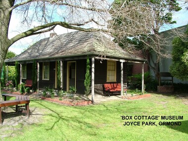
Photograph - ' Box Cottage' Reconstruction, c1841
The original small, pioneer cottage was built in the late 1840s to early1850s, by an unknown pioneer. It was located on part of a 30 Acre allotment that was originally part of Henry Dendy’s Special Survey granted in 1841. The doors and window sashes, (made of red deal joinery timber), as well as the brass locks and fittings, are from the original cottage, and were imported from England.The fire-place bricks are from the original cottage, and are sun-dried, (not kiln fired), and are hand-made. Convict marks can be seen on two bricks.There is a small display of external cladding shingles from the original pioneer cottage. These shingles were hand-split, and most likely made from locally collected timber The nails included in this display were used to fasten the shingles on the original cottage, and are also hand-made. The enamel nameplate, “Colonial”, on the wall of the cottage, was the name chosen for the original pioneer cottage when a later owner, Mr August Rietman and wife Frieda leased the property in around 1917. August purchased the property 1935 for 1200 Pounds approximately and resided there until 1953. In 1974 Mr Lewis, a timber specialist, found the dilapidated building on property he had recently purchased in Jasper Rd and suggested it be reconstructed and relocated. Moorabbin Council agreed and the Cottage was rebuilt just about 250 metres from its original site. The cost of the rebuild was met by 'Victoria's 150th Committee, plus a small grant from the City of Moorabbin, and Mr Laurie Lewis donated much of the timber for the reconstruction. Although 'Box Cottage' is a re-construction, it is an unique museum that, being located in the midst of a modern community in Ormond Victoria, can educate and demonstrate many aspects of the early settler’s way of life in Victoria. As such, it is an invaluable resource for students and all kinds of visitors. The original small, pioneer cottage was built in the late 1840s to1850s, by an unknown pioneer. It was located on part of a 30 Acre allotment that was originally part of Dendy’s Special Survey granted in 1841. The re-constructed pioneer cottage, named ‘Box Cottage’, is located only a matter of metres from the original pioneer cottage site, in Joyce Park, Jasper Road, Ormond, Victoria. The museum has copies of interesting Land Titles associated with the surrounding land, including the site of the original pioneer cottage, from Dendy’s time, and into the 1900s. ‘Box Cottage’ is named after the pioneers, William and Elizabeth Box, who resided in the original cottage from approximately 1865, until Elizabeth’s death in 1914.The re-constructed cottage plan has followed faithfully the original dimensions, and plan of the original pioneer cottage, and as many original items from that cottage’s long occupation have been incorporated. Convict marks on sun -dried, fire-place chimney bricks. Enamel nameplate 'Colonial' circa1915brighton, moorabbin, cottages, pioneers, ormond, colonial, mckinnon, dendy henry, box william, box elizabeth, convicts, rietman august, rietman frieda, rietman stefanie -
 City of Moorabbin Historical Society (Operating the Box Cottage Museum)
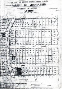
Flyer - Garfield Estate, Ormond
At the end of World War One, there was a renewed interest in residential land and a number of estates opened up in the Municipality of Moorabbin.Example of the progress of the Municipality of MoorabbinPhotocopy of the plan of the Garfield Estate, OrmondPart f Dendy's Crown Special Survey - parish of Moorabbin - County of Bourke - Garfield Estatedraper street, lord street, hudson street, blackshaw street, tucker road, ormond, mckinnon, real estate -
Bendigo Historical Society Inc.
Map - CAMPBELL COLLECTION: BENDIGO AND DISTRICT MAPS, 22-3-29
... Survey and Parish Plans. B.W.L.22-3-29 (number 389 in map... in W.P.B. fro Field Survey and Parish Plans. B.W.L.22-3-29 (number ...Map. Marong, Parishes of Marong, Lockwood and Mandurang, Scale 20 chains to 1 inch, Total area 5106 acres. Crusoe Reservoir & Viaduct and water race. Compiled in W.P.B. fro Field Survey and Parish Plans. B.W.L.22-3-29 (number 389 in map cupboard 1)B.W.L.map, bendigo, allotments -
Bendigo Historical Society Inc.
Map - CAMPBELL COLLECTION: BENDIGO & DISTRICT MAPS, 22-3 29
... Reservoir on right. Compiled in W.P.B. from Field Survey and Parish... Reservoir on right. Compiled in W.P.B. from Field Survey and Parish ...Map. Marong, Parishes of Marong, Lockwood and Mandurang. Scale 20 chains to an inch. Total area 5106 acres. Crusoe Reservoir on right. Compiled in W.P.B. from Field Survey and Parish Plans (number 373 in map cupboard 1)G.W.Lmap, bendigo, allotments -
Bendigo Historical Society Inc.
Map - CAMPBELL COLLECTION: BENDIGO AND DISTRICT MAPS
... . from Field Survey and Parish Plans. Crusoe Reservoir... in W.P.B. from Field Survey and Parish Plans. Crusoe Reservoir ...Map. Marong, Parishes of Marong, Lockwood and Mandurang. Scale 20 chains to an inch. Total 5106 acres. Compiled in W.P.B. from Field Survey and Parish Plans. Crusoe Reservoir to the right of map. (number 362 in map cupboard 1)map, bendigo, parish plan -
Bendigo Historical Society Inc.
Book - 'BULLETINS OF THE GEOLOGICAL SURVEY OF VICTORIA NO. 30'. THE PEARL AND HERCULES AND ENERGETIC MINES, BENDIGO, 1914
Bulletins of the Geological Survey of Victoria No. 30. The Pearl and Hercules and Energetic Mines, Bendigo, with plans and sections. By W. Baraganath Underground maps of the 4 (four) mines referred to in this book. Priced six pence Inscribed on the front cover: A. Richardson, 29 Harrison Street, Bendigo.Department of Mines. By W. Baraganathbendigo, mining, early history., mining, pearl, hercules and energetic mines. -
Bendigo Historical Society Inc.
Document - STRUCTURE OF BENDIGO GOLDFIELD BULLETIN NO. 47
Booklet, 36 pages, that describes the structure of the Bendigo Goldfield. Booklet is enclosed in an envelope. On front of booklet : 1923 Victoria, Department of Mines, Bulletins of the Geological Survey of Victoria, W. Baragwanath, Director. Structure of Bendigo Goldfield, by H. Herman, late Director of Geological Survey. Maps under catalogue number 3769 accompanied the booklet and are listed as 'plates' on the contents page. Plans and Sections to accompany Bulletin No 47, Structure of Bendigo Gold-Field, by H Herman, B.C.E., M.M.E., F.G.S., late Director of Geological Survey.Geological Survey of Victoriabendigo, gold mining, structure of goldfield, bendigo, goldfield, gold mining, geology -
Bendigo Historical Society Inc.
Map - HUSTLER'S & CHRISTMAS LINES OF REEFS - PLAN OF LINES OF SECTION OF REEFS
... Underground Survey of Mines Bendigo. Plan of Cross Section... Underground Survey of Mines Bendigo. Plan of Cross Section Lines ...Underground Survey of Mines Bendigo. Plan of Cross Section Lines Shewing Connections with Trigonometrical Stations and Base Lines. 13/3/99 Signed ? Stirling. Places and mines mentioned Speciman Hill, Tambour Major, Lansell's 180, Victory and Pandora, Great Extended Hustler's, Windmill Hill on Victoria Reef. Next part of map is a Plan of Lines of Section between the Hustler's and Christmas Lines of Reefs. 8/3/99. Signed ?. Transverse Section. Shows Tambour Major Co., near the Christmas Line of Reef, Crosscuts and their depth, geological features and stone encountered. Then shows Thistle Line, Charshalton Line, Napoleon Line, Nell Gwynne Line, New Chum Line, Lansell's No 180 with levels, depths and geological features. Drawing is continued in three parts to fit on paper. Lansell's East Shaft with levels and depths, geological features and stone encountered. Sheepshead Line, Old Shaft, Garden Gully Line, Victory and Pabndora Co with crosscuts, depths, geological features and stone encountered. Paddy's Gully Line, Derby Line, Millers Line, Hustler's Line, Great Extended Hustler's Co with levels, depths, geological features and stone encountered. A note beside a Saddle Reef: 360,000 pounds paid in dividends from this reef. Average ounces per ton gold noted where found. Reference Table for stone and geological features. Datum Line 700 feet above Sea Level Unscannedmining, parish map, hustler's & christmas lines of reefs, plan of lines of section of reefs, ? stirling, specimen hill, tambour major, lansell's 180, victory & pandora, great extended hustler's, windmill hill, victoria reef, tambour major co, christmas line, hustler's line, thistle line, carshalton line, napoleon line, nell gwynne line, new chum line, lansell's no 180, lansell's east shaft, sheepshead line, old shaft, garden gully line, paddy's gully line, derby line, miller's line, hustler's line, great extended hustler's co -
 Bendigo Historical Society Inc.
Document - HUSTLERS REEF - PLANS & SECTIONS TO ACCOMPANY BULLETIN NO 33
Pink page pasted onto cream card titled Plans and Sections to accompany Bulletin No 33. Hustler's Line of Reef, Bendigo by H S Whitelaw, by Authority: Albert J. Mullett, Government Printer, Melbourne. Plate No 1 to No 34. Mines mentioned: Fortuna Hustler's Mine, Hustler's Royal Reserve No 2 Mine, Hustler's Royal Reserve Mine Park Shaft, Great Extended Hustler's Mine, Hustler's Reef and Hustler's Reef No 1 Mines, Hustler's Reef Mine, Comet Mine, United Hustler's and Redan Mine, K. K. Mine, Hustler's Consols Mine, Fortuna Hustler's Mine. Department of Mines Geological Survey of Victoria 1914. Written on the back: Lightning Hill area to Summer Hill.document, hustlers reef, plans & sections to accompany bulletin no 33, geological survey of victoria, department of mines, hustler's line of reef, h s whitelaw, fortuna hustler's mine, hustler's royal reserve no 2 mine, hustler's royal reserve mine park shaft, great extended hustler's mine, hustler's reef mine, hustler's reef no 1 mine, comet mine, united hustler's mine, redan mine, k k mine, hustler's consols mine, fortuna hustler's mine, hustler's consols mine, albert j mullett, government printer melbourne