Showing 304 items matching "princes bridge, melbourne"
-
 Lakes Entrance Historical Society
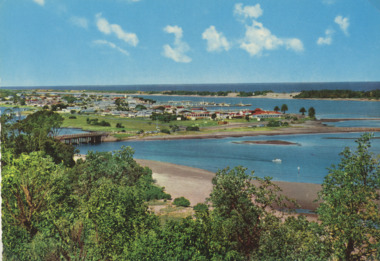
Postcard - Views of Lakes Entrance c1970, John Engelander and Co Melbourne, 1970 c
Princes Highway to town showing concrete bridge over North Arm . Also identical postcard with message on back in Spares boxColour postcard of view from Princes Highway to town showing concrete bridge over North Arm old toilet block opposite road to Bullock Island, Club Spit being formed, Hill 60 visible on outer barrier hummocks Lakes Entrance Victoriaroads and streets, township, waterways -
 Port Melbourne Historical & Preservation Society
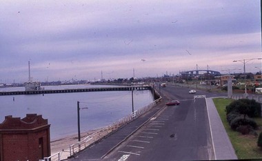
Photograph - Port Melbourne beach looking west towards West Gate bridge early 1980s
... Gate Bridge Piers and Wharves - Princes Pier Centenary Bridge ...Shows the land area to the right which was later redeveloped as Beacon CovePort Melbourne beach looking west towards West Gate bridge early 1980s. Princes Pier. Down ramp from Centenary Bridge. Circa early 1980sbuilt environment, built environment - west gate bridge, piers and wharves - princes pier, centenary bridge -
 Melbourne Tram Museum
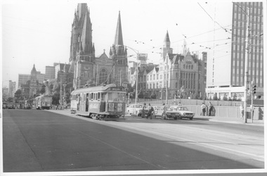
Photograph - W2 254 on Princes Bridge, c1970s
Photograph of W2 254 after crossing Princes Bridge approaching Flinders St with other trams ahead of it. The camera looks across the rail bridge towards St Paul's Cathedral with part of the Gas and Fuel Building at right. W2 254 is northbound to "Moreland route 15" and is fitted with the improved end lights added n the early 1970s. It is a warm sunny afternoon with several saloon windows open on 254 and pedestrians in shirt sleeves and bell-bottom trousers. Several southbound motor cars are stationary at the Batman Ave traffic lights.Yields information about Melbourne in 1970s Black and white print with no note on rearw2 class, 254, moreland, route 15, st paul's cathedral, princes bridge, flinders st, batman ave, gas and fuel building, bell-botom trousers -
 Port Melbourne Historical & Preservation Society
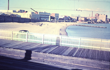
Photograph - Port Melbourne beach front from Station Pier, February, Marie Hillier, Feb 1960
Digital image taken from Station Pier, in February 1960, looking east along beachfront. Image shows part of Centenary Bridge; Swallow and Ariell buildings including chimney (since demolished); London Hotel; Princes St drain pier; Graham St gasometer in background; Sandridge Bay Towers; rotunda. Station pier shows raised pedestrian walkway, vehicle on lower level and rails that extend from station.built environment - commercial, built environment - industrial, natural environment - beaches and foreshore, piers and wharves - station pier, centenary bridge, london family hotel, band rotunda, swallow & ariell ltd, gasometer, sandridge towers, piers and wharves - miscellaneous