Showing 632 items
matching river st
-
 Man From Snowy River Museum operated by the Upper Murray Historical Society
Newspapers, Corryong Courier 1965, 1965
Social & Commercial History of DistrictSocial & Commercial History of DistrictNavy Blue Bound Copies - Jan 1965 to Dec 1965Gold Lettering local newspaper -
Man From Snowy River Museum operated by the Upper Murray Historical Society
Newspapers, Corryong Courier 1966, 1966
Social & Commercial History of DistrictSocial & Commercial History of DistrictNavy Blue Bound Copies - Jan 1966 to Dec 1966Gold Letteringlocal newspaper -
Man From Snowy River Museum operated by the Upper Murray Historical Society
Newspapers, Corryong Courier 1967, 1967
Social & Commercial History of DistrictSocial & Commercial History of DistrictNavy Blue Bound Copies - Jan 1967 to Dec 1967Gold Letteringlocal newspaper -
Man From Snowy River Museum operated by the Upper Murray Historical Society
Newspapers, Corryong Courier 1968, 1968
Social & Commercial History of DistrictSocial & Commercial History of DistrictNavy Blue Bound Copies - Jan 1968 to Dec 1968Gold Letteringlocal newspaper -
Tatura Irrigation & Wartime Camps Museum
Packing Slip Envelope, pre 1990
Spencer Street Railway Station now known as Southern Cross.Regular size envelope, brown paper. Meant to hold packing slip. Has reinforced hole for tying to parcels. Wording indicates to be used at State Rivers and Water Supply Commission store yards at South Melbourne for Government carrier to Spencer Street Railway Station.To SRWSC Spencer St Railway Station per Government courier to SR & WSC store yard Brady Street South Melbourne. On rear are instructions to carrier.spencer street railway station, srwsc -
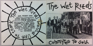 Williamstown High School
Committed to soul CD - 1993, Committed to soul, 1993
Band members: Anthony Bethell - bass guitar; Jamila Brogan - brass; Aicha Brogan - brass; Milisa Inglis - backing vocals; Steven Jones - guitar, brass, keyboard; Jeremy King - guitar; Finn Koren - keyboard; Timothy Miedecke - vocals, guitar, bass; Shaun Murray - brass; Samantha Simpson - vocals, drum; George Smpyrakis - brass; Deidre Waight - backing vocals. Also: Ian, Penny and Lex (horn arrangements) Aydin Abdullah (horn director) Colin Wiseman (photography.1 CD in jewel case. Includes playlist on the reverse and list of band members with black and white photograph inside the front cover. Produced by Milisa Inglis & Finn Koren. Engineered by Neil Gray at Trueform Studios. Made in Australia by Disctronics.See 2 images attached.music, williamstown high school, the wet reeds, committed to soul, mustang sally, destination anywhere, i feel good, take me to the river, chain of fools, shake your tailfeather, 1993 -
 Tatura Irrigation & Wartime Camps Museum
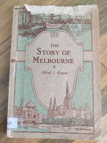
Book, The Story of Melbourne, 1934
Cream, pale green cover. Brown lettering. Sketches of early discovery scene and Yarra river, Flinders Street, Station and St. Paul's Cathedralthe story of melbourne, kenyon af, stewart f, tatura, victorian history, sir gengoult-smith -
 Robin Boyd Foundation
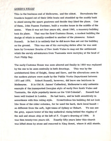
Document - Manuscript, Robin Boyd, Queen’s Wharf, 1966
Boyd takes a brief look at the oldest part of Melbourne, and the Customs House.Published as a chapter titled 'Customs House – Yarra River – Queen's Bridge' in The Book of Melbourne and Canberra, The Griffin Press, Adelaide 1966Typewritten (c copy), quarto, 1 pagecustoms house, melbourne, robert russell, old st james cathedral, robin boyd, manuscript -
 Robin Boyd Foundation
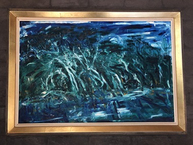
Painting, Kevin Connor, Metung, 1964
“Metung” by Kevin Connor was a birthday present from Robin Boyd to his wife Patricia circa 1964.Predominantly blue and green landscape of trees, sky and river.Signature and date on lower right.kevin connor, patricia boyd, robin boyd, walsh st artwork, ohm2022, ohm2022_26 -
 Robin Boyd Foundation
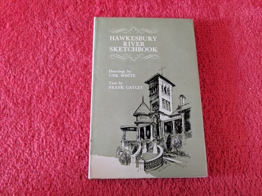
Book, Unk White, Hawkesbury River Sketchbook, 1970
Hardcover w/ Dust JacketDedication written inside front cover - "To Robin, 1971". Also, clipping dated 27/1/71 about Melbourne's Underground Rail Loop Authority citing the value of having Robin Boyd on the Authority.walsh st library -
 Robin Boyd Foundation
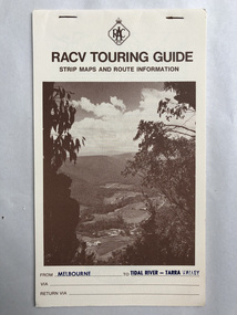
Pamphlet, RACV, Strip Maps Melbourne to Tidal River-Tarra Valley
walsh st library -
 Robin Boyd Foundation
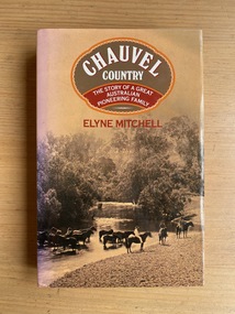
Book, Elyne Mitchell, Chauvel Country: The Story of a Great Australian Pioneering Family, 1983
Hardcover w/ Dust JacketDedication "To Dad", dated Christmas 1983australian biography, chauvel family, genealogy, family history, clarence river, tabulam, new south wales, walsh st library -
 Uniting Church Archives - Synod of Victoria
Photograph, St Philip's College Alice Springs - Principal Chris Tudor & Deputy Principal Chris Eldridge, 09/1986
In 1945 the Reverend Harry Griffiths, who worked for the Methodist Inland Mission in Alice Springs, saw the need for a boarding facility for children of families living in remote areas in Central Australia who needed access to schools. He and his wife established Griffiths House, on a site in the town centre, and for many years it became home for students from all over the Outback, including many young Aboriginal people. In the late 1950's the Rev Fred McKay, successor to the Rev John Flynn as Superintendent of the Australian Inland Mission, lobbied the United Church in the Northern Territory to build and expand on this important start. Together the Presbyterian, Methodist and Congregational churches embarked on a missionary venture to develop St Philip's College - a new, larger residential hostel which would one day become a full boarding school. An ideal site - 22 acres of bush at the junction of the Charles and Todd Rivers and backing on to the Telegraph Station National Park - was secured and after six years of planning, construction began in 1964. Fred McKay led the legendary work parties comprised of volunteers from all over Australia who travelled to Alice Springs, paying their own way and volunteering their expertise, time and labour, to turn a dream into a reality. This fantastic tradition continues today, with work parties arriving each mid-year holiday. On 13 February 1965 the first boarders moved in to St Philip's College. For the first 24 years, therefore, St Philip's College operated as a residential hostel only. The College’s ninth Headmaster, Mr Christopher Tudor, arrived in 1986. He and the Council Chairman, Mrs Jan Heaslip, judged that the time was right to complete the original plan to turn St Philip’s College into a fully fledged independent boarding/day school, serving not only “bush” families, but also the growing population of Alice Springs. The then College Council embraced the idea and three years of frantic, determined preparation and planning commenced, culminating in an extensive $2 million building program in 1988. To this day there continues to be further development with the new landscaping underway near The Minnamurra Hall, Reception and Rivergum Cafe, plus the recent completion of the Science & Food Technology building and the new Rivergum Cafe.Head & Shoulders of Chris Eldridgest. philip's college, tudor, chris, eldridge, chris -
 Uniting Church Archives - Synod of Victoria
Photograph, St Philip's College Alice Springs - Principal Chris Tudor & Deputy Principal Chris Eldridge, 09/1986
In 1945 the Reverend Harry Griffiths, who worked for the Methodist Inland Mission in Alice Springs, saw the need for a boarding facility for children of families living in remote areas in Central Australia who needed access to schools. He and his wife established Griffiths House, on a site in the town centre, and for many years it became home for students from all over the Outback, including many young Aboriginal people. In the late 1950's the Rev Fred McKay, successor to the Rev John Flynn as Superintendent of the Australian Inland Mission, lobbied the United Church in the Northern Territory to build and expand on this important start. Together the Presbyterian, Methodist and Congregational churches embarked on a missionary venture to develop St Philip's College - a new, larger residential hostel which would one day become a full boarding school. An ideal site - 22 acres of bush at the junction of the Charles and Todd Rivers and backing on to the Telegraph Station National Park - was secured and after six years of planning, construction began in 1964. Fred McKay led the legendary work parties comprised of volunteers from all over Australia who travelled to Alice Springs, paying their own way and volunteering their expertise, time and labour, to turn a dream into a reality. This fantastic tradition continues today, with work parties arriving each mid-year holiday. On 13 February 1965 the first boarders moved in to St Philip's College. For the first 24 years, therefore, St Philip's College operated as a residential hostel only. The College’s ninth Headmaster, Mr Christopher Tudor, arrived in 1986. He and the Council Chairman, Mrs Jan Heaslip, judged that the time was right to complete the original plan to turn St Philip’s College into a fully fledged independent boarding/day school, serving not only “bush” families, but also the growing population of Alice Springs. The then College Council embraced the idea and three years of frantic, determined preparation and planning commenced, culminating in an extensive $2 million building program in 1988. To this day there continues to be further development with the new landscaping underway near The Minnamurra Hall, Reception and Rivergum Cafe, plus the recent completion of the Science & Food Technology building and the new Rivergum Cafe.Head & Shoulders of Chris Tudor.st. philip's college, tudor, chris, eldridge, chris -
 Uniting Church Archives - Synod of Victoria
Photograph, St Philip's College Alice Springs - Principal Chris Tudor & Deputy Principal Chris Eldridge, 09/1986
In 1945 the Reverend Harry Griffiths, who worked for the Methodist Inland Mission in Alice Springs, saw the need for a boarding facility for children of families living in remote areas in Central Australia who needed access to schools. He and his wife established Griffiths House, on a site in the town centre, and for many years it became home for students from all over the Outback, including many young Aboriginal people. In the late 1950's the Rev Fred McKay, successor to the Rev John Flynn as Superintendent of the Australian Inland Mission, lobbied the United Church in the Northern Territory to build and expand on this important start. Together the Presbyterian, Methodist and Congregational churches embarked on a missionary venture to develop St Philip's College - a new, larger residential hostel which would one day become a full boarding school. An ideal site - 22 acres of bush at the junction of the Charles and Todd Rivers and backing on to the Telegraph Station National Park - was secured and after six years of planning, construction began in 1964. Fred McKay led the legendary work parties comprised of volunteers from all over Australia who travelled to Alice Springs, paying their own way and volunteering their expertise, time and labour, to turn a dream into a reality. This fantastic tradition continues today, with work parties arriving each mid-year holiday. On 13 February 1965 the first boarders moved in to St Philip's College. For the first 24 years, therefore, St Philip's College operated as a residential hostel only. The College’s ninth Headmaster, Mr Christopher Tudor, arrived in 1986. He and the Council Chairman, Mrs Jan Heaslip, judged that the time was right to complete the original plan to turn St Philip’s College into a fully fledged independent boarding/day school, serving not only “bush” families, but also the growing population of Alice Springs. The then College Council embraced the idea and three years of frantic, determined preparation and planning commenced, culminating in an extensive $2 million building program in 1988. To this day there continues to be further development with the new landscaping underway near The Minnamurra Hall, Reception and Rivergum Cafe, plus the recent completion of the Science & Food Technology building and the new Rivergum Cafe.Tudor and Eldridge in conversation with the College in the background.st. philip's college, tudor, chris, eldridge, chris -
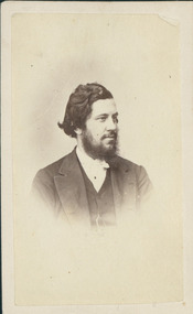 Uniting Church Archives - Synod of Victoria
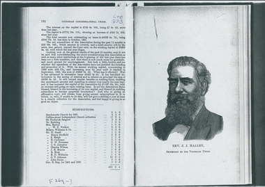
Photograph, Rev. Jacob John Halley, 1850-1869
Born Highbury College London 1834, died Melbourne June 19, 1910. Ordained in Pitt Street Sydney Congregational Church 21/3/1860. Ministry: Bush Mission, Lower Darling River 1860–61; Maryborough 1861–64; Dawson St Ballarat 1864–72; Williamstown/Secretary CUV 1872–84; Secretary CUV 1884–1908. Chairman CUV 1871–72 & 1908–09. Son of Rev. Dr Robert Halley, Principal of Highbury College. Arrived Sydney c. 1853. Had a holiday home at Queescliff/Point Lonsdale and tried to establish a Congregational Church there. Obituary read: "For 37 years in the office of Union Secretary he had proved himself a faithful preacher of the Gospel, a leader of the general interest of the churches of peculiar force, knowledge and devotion, and an earnest and high principled citizen of the State, devoting hmself to the social amelioration of the people and the extension of the Kingdom of God. Our late Secretary was a man of vigorous intellectual power. His early life had given him a bent in the direction of the study of natural history. He was a keen observer, a lover of counry life, and the science and art of gardening, in which he occupied the leisure moments of a busy life."Portrait of Halley c. 1850–1869."C. 1850–1869 Rev. J. J. Halley, Cong. Union"halley, j. j., congregational church -
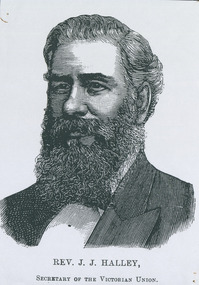 Uniting Church Archives - Synod of Victoria
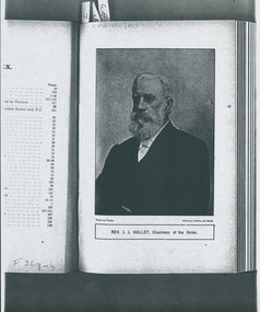
Photocopy of engraving, Rev. Jacob John Halley
Born Highbury College London 1834, died Melbourne June 19, 1910. Ordained in Pitt Street Sydney Congregational Church 21/3/1860. Ministry: Bush Mission, Lower Darling River 1860–61; Maryborough 1861–64; Dawson St Ballarat 1864–72; Williamstown/Secretary CUV 1872–84; Secretary CUV 1884–1908. Chairman CUV 1871–72 & 1908–09. Son of Rev. Dr Robert Halley, Principal of Highbury College. Arrived Sydney c. 1853. Had a holiday home at Queescliff/Point Lonsdale and tried to establish a Congregational Church there. Obituary read: "For 37 years in the office of Union Secretary he had proved himself a faithful preacher of the Gospel, a leader of the general interest of the churches of peculiar force, knowledge and devotion, and an earnest and high principled citizen of the State, devoting hmself to the social amelioration of the people and the extension of the Kingdom of God. Our late Secretary was a man of vigorous intellectual power. His early life had given him a bent in the direction of the study of natural history. He was a keen observer, a lover of counry life, and the science and art of gardening, in which he occupied the leisure moments of a busy life."Photocopy of engraving from the Congregational Year Book for 1893.halley, j. j., congregational church -
 Uniting Church Archives - Synod of Victoria
Photograph, Rev. Jacob John Halley
Born Highbury College London 1834, died Melbourne June 19, 1910. Ordained in Pitt Street Sydney Congregational Church 21/3/1860. Ministry: Bush Mission, Lower Darling River 1860–61; Maryborough 1861–64; Dawson St Ballarat 1864–72; Williamstown/Secretary CUV 1872–84; Secretary CUV 1884–1908. Chairman CUV 1871–72 & 1908–09. Son of Rev. Dr Robert Halley, Principal of Highbury College. Arrived Sydney c. 1853. Had a holiday home at Queescliff/Point Lonsdale and tried to establish a Congregational Church there. Obituary read: "For 37 years in the office of Union Secretary he had proved himself a faithful preacher of the Gospel, a leader of the general interest of the churches of peculiar force, knowledge and devotion, and an earnest and high principled citizen of the State, devoting hmself to the social amelioration of the people and the extension of the Kingdom of God. Our late Secretary was a man of vigorous intellectual power. His early life had given him a bent in the direction of the study of natural history. He was a keen observer, a lover of counry life, and the science and art of gardening, in which he occupied the leisure moments of a busy life."Photocopy of engraving from the Congregational Year Book for 1893.halley, j. j., congregational church -
 Uniting Church Archives - Synod of Victoria
Photograph, 1987
... Anne Hedt was Director of Music at St Leonard's Patterson... Director of Music at St Leonard's Patterson River campus.... at St Leonard's Patterson River campus. hedt, anne kellett ...Anne Hedt was Director of Music at St Leonard's Patterson River campus.B&W photograph showing Thomas Kellett student and Anne Hedt Director of Music at St Leonard's Patterson River campus."Thomas Kellett and Anne Hedt C&N 8/7/1987 page 16"hedt, anne, kellett, thomas, st leonard's college -
 Uniting Church Archives - Synod of Victoria
Photograph, 1985
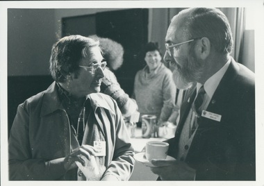
Rev Frank Morris Ordained in the Methodist Church 1966, Minster at Casterton 1966-1968, Yarram 1969-1971, Tasmania LA 1972-1989, Glamorgan 1990-1993, Hobart City Centre 1994-1995, PR 1995. Rev Des Ivens Ordained 1970 SA Minster at Robe 1963, Port MacDonnell 1964-1966, Plympton (Hare St) 1967, Bute 1968-1970, Rocky River (Laura) 1971-1973, Barunga Range 1974-1976, Kangaroo Island 1977-1981, Huon Tas 1982-1985, SA, Wallaroo 02.86 B & W waist length photograph of the Rev. Frank Morris and the Rev. Des Ivens in conversation.rev. frank morris; rev. des ivens; casterton; yarram; hobart city centre; robe; port macdonnell; plympton; bute; rocky river; barunga range; kangaroo island; huon tasmania; wallaroo -
 Uniting Church Archives - Synod of Victoria
Photograph, Undated c.1920
... Castlemaine; 1905 Dimboola; 1909 Geelong, Yarra St.; 1913 Kilcunda... Castlemaine; 1905 Dimboola; 1909 Geelong, Yarra St.; 1913 Kilcunda ...James Rogers was born in Wallaroo, South Australia, but came to Sailor's Gully, Eaglehawk with his family as an infant. He was converted in a Salvation Army meeting at Bendigo. He became a member of the Primitive Methodist Church at Eaglehawk. He was stationed at: 1888 Murtoa; 1889 Hamilton; 1892 Melbourne, Collingwood; 1892 Beaconsfield; 1894 Penguin; 1900 Castlemaine; 1905 Dimboola; 1909 Geelong, Yarra St.; 1913 Kilcunda & Powlett River; 1917 Kyabram; 1920 North Melbourne; 1923 Brighton; 1928 Prahran; 1932 Supernumerary Hawthorn. Gaol Chaplain 1909 - 1912; Hospital Chaplain 1935 - 1936Died 2nd September 1937 Agnes Rogers (nee Caldwell) was born in 1867, married James Rogers in 1892 and died in 1951.B & W studio portrait of Rev James Rogers and Mrs Agnes Rogers (nee Caldwell)james rogers, agnes rogers, agnes caldwell, methodist, primitive methodist, eaglehawk, minister -
 Uniting Church Archives - Synod of Victoria
Photograph, Undated c.1914 - 1918
... Castlemaine; 1905 Dimboola; 1909 Geelong, Yarra St.; 1913 Kilcunda... Castlemaine; 1905 Dimboola; 1909 Geelong, Yarra St.; 1913 Kilcunda ...James Rogers was born in Wallaroo, South Australia, but came to Sailor's Gully, Eaglehawk with his family as an infant. He was converted in a Salvation Army meeting at Bendigo. He became a member of the Primitive Methodist Church at Eaglehawk. He was stationed at: 1888 Murtoa; 1889 Hamilton; 1892 Melbourne, Collingwood; 1892 Beaconsfield; 1894 Penguin; 1900 Castlemaine; 1905 Dimboola; 1909 Geelong, Yarra St.; 1913 Kilcunda & Powlett River; 1917 Kyabram; 1920 North Melbourne; 1923 Brighton; 1928 Prahran; 1932 Supernumerary Hawthorn. Gaol Chaplain 1909 - 1912; Hospital Chaplain 1935 - 1936Died 2nd September 1937 Agnes Rogers (nee Caldwell) was born in 1867, married James Rogers in 1892 and died in 1951. The children in the photograph are: James Stanley (born 1893), John David (born 1895), Agnes Pricilla (born 1897), Robert Leslie (born 1899), Jean (born 1900), Ethel Margaret (born 1903), Amelia Florence (born 1905) Lois Susan and Ella (twins born 1908).B & W studio photograph of Rev James Rogers, Mrs Agnes Rogers (nee Caldwell) and their children. The images of two men in uniform (presumably absent overseas) have been superimposed on the photograph to complete the family group. james rogers, agnes rogers, agnes caldwell, methodist, primitive methodist, eaglehawk, minister, first world war -
 Stawell Historical Society Inc
Photograph, "Woodlands" Homestead near Crowlands on Wimmera River by Johann von Guerard 1869 -- Photo of an Oil Painting
Photograph of Oil on Canvass of Woodlands Homestead near Crowlands on Wimmera River 1869 by Johann von Guerardstawell -
 Stawell Historical Society Inc
Photograph, Bush Saw Mill on the Wimmera river 1887
Bush Saw Mill by Charles Nettleton. Wimmera River of Victorian 1887stawell manufacture -
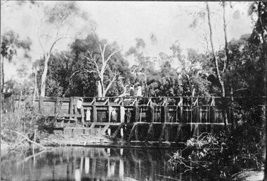 Stawell Historical Society Inc
Photograph, Weir on the Wimmera River between Glenorchy & Campbells Bridge -- Postcard
Weir on Wimmera River between Glenorchy & Campbells Bridgestawell -
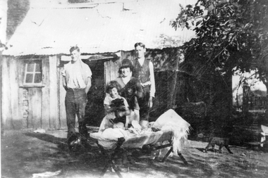 Stawell Historical Society Inc
Photograph, Mr Fred Howard & Mrs Laura Howard nee Unknown at their Dadswell Bridge Home
Home of Fred & Laura Howard married 1902. Standing in front of Slab hut home are four people. Jack Howard, Alan (Ike) Howard. Rene Howard, Sorrie Howard and the twins in the crib Rodger and Andrew Howard. Little Wimmera River Dadswell's Bridge.Black and white photograph of a family group in front of a timber slab home with a corrugated iron roof. The family group consists of two standing and two closer to a crib with two young babies. Two of the females look to be holding animals and a cat can be seen nearby. Jack Howard, Alan (Ike) Howard, Rene Howard, Dorrie Howard and the twins in the crib, Rodger Howard and Andrew Howard. house -
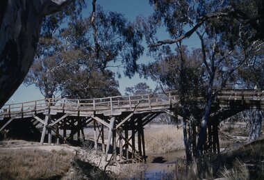 Stawell Historical Society Inc
Slide, Ian McCann, Wimmera River Bridge at Joel 1957, 1957
... Stawell Historical Society Inc 46 Longfield St Stawell ...Wimmer River Bridge at Joel 1957wimmera river, joel area, joel bridge -
 Stawell Historical Society Inc
Photograph, Carrs Plains Wettenhall CD, 2006
5563-2a Sheep Carrs Plains 5563-2a1 Carrs Plains on bank of Richardson River 5563-2a2 Carrs Plains Molly with Calf 5563-2b Richardson River in Flood 5563-2b1 Carrs Plains 5563-2b2 Arthur Whettenhall at front door 5563-2c Slush boxes Carrs Plains 5563-2c1 Carrs Plains 5563-2c2 Wettenhall Family1890 Viola on Holford's lap 5563-2d Seven Bros 5563-2d1 Carrs Plains 5563-2d2 Snow at Carrs Plains about 1896 5563-2e Carrs Plains 5563-2e1 Carrs Plains 5563-2e2 Carrs Plains Quarters 5563-2f Sheep 5563-2f1 Carrs Plains 5563-2f2 Sheep & Fleece 5563-2g Sheep 5563-2g1 Carrs Plains 5563-2g2 Carrs Plains Staff 5563-2h Alan Wettenhall 5563-2h1 Carrs Plains 5563-2h2 Portrait of 5563-2i Carrs Plains Grp 5563-2i1 Mr Tom Thumb the pony at Carrs Plains 5563-2i2 CP Top Sheep 5563-2j Roland Viola Alexander 5563-2j1 H H Wettenhall 5563-2j2 Carrs Plains Riding 5563-2k Sheep 5563-2k1 H H Wettenhall 5563-2k2 Carrs Plains sheep 5563-2l Carrs Plains front door on R 5563-2l1 H H Wettenhall false left arm 5563-2l2 Carrs Plains slush box 5563-2m Carrs Plains Rams 5563-2m1 H H Wettenhall 5563-2m2 Carrs Plains wool away 5563-2n Carrs Plains 5563-2n1 Carrs Plains 5563-2n2 Snow at Carrs Plains 5563-2o Carrs Plains Shearing 5563-2o1 Shoot 5563-2p Carrs Plains Shearing 5563-2p1 Party At Dam possibly Lake Lonsdale 5563-2q Carrs Plains Sheep 5563-2q1 Carrs PLains 5563-2r Carrs Plains Sheep 5563-2r1 Carrs Plains 5563-2s Carrs Plains Flood 5563-2s1 Carrs Plains 5563-2t Carrs Plains Flood 5563-2t1 Carrs Plains Duck 5563-2u Carrs Plains Flood 5563-2u1 Carrs Plains Sheep 5563-2v Veranda Carrs Plains 5563-2v1 Mrs Tom Thumbs Foal Tempus 5563-2w Carrs Plains Flood 5563-2w1 Molly and her Kemp family ,her mother Euphemia and Gd Mother Kemp 5563-2x Carrs Plains Flood 5563-2x1 Jean Kemp Molly's oldest sister 1909 5563-2y Carrs Plains Barns 5563-2y1 G G Mother Kemp 94yrs Herbert on R 5563-2z Carrs Plains Playing 5563-2z1 Carrs Plains Buggy Photographs of Carrs Plain on CDstawell -
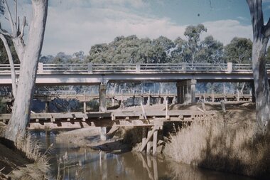 Stawell Historical Society Inc
Slide, Ian McCann, Three Bridges
Three Bridges across a river, two oled wooden ones and the newer concrete one in the centre. at Campbells Bridgebridges, campbells bridge