Showing 634 items matching "river view"
-
 Port Melbourne Historical & Preservation Society
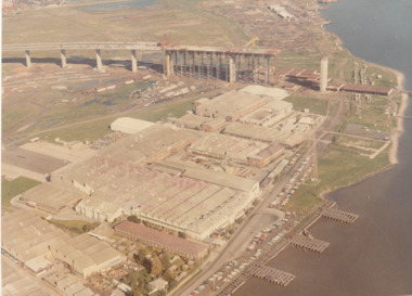
Photograph - Aerial view of West Gate Bridge under construction, 1960 - 1979
Colour aerial (faded) photograph of West Gate Bridge under construction with two land spans incomplete. "Rotten Row" (disused old piers) in the foreground. Aircraft factory and other industry in foreground."Master Copy . Not to be removed from Marketing department " lightly stamped on photo. and on reartransport, engineering, engineering - bridges, fishermans bend, industry, west gate bridge, rotten row, williamstown, yarra river -
 Port Melbourne Historical & Preservation Society
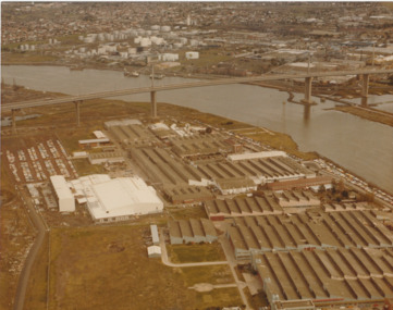
Photograph - Aerial view of West Gate Bridge under construction, 1970 - 1979
Colour aerial photograph of West Gate Bridge completed. Aircraft factory and other industry in foreground. Williamstown and fuel storage tanks in background (Coode Island)"Gov't A/C Factories Photographic Section Neg No N2841/3" stamped on backtransport, engineering, engineering - bridges, fishermans bend, industry, west gate bridge, rotten row, williamstown, yarra river -
 Port Melbourne Historical & Preservation Society
Photograph - Aerial view of Yarra River and surrounds, 1990s
... Aerial view of Yarra River and surrounds... skyline. Taken mid 1990s Photograph Aerial view of Yarra River ...COPYRIGHT THE AGE Aerial photograph showing the Yarra River, Webb Dock, Port Melbourne beach, Princes pier, West Gate Bridge, Maribyrnong River, Swanston Dock and Melbourne City skyline. Taken mid 1990sStamped "Copyright. This photograph may not be reproduced without permission in writing from the Photo sales department of "the Age"'built environment - commercial, engineering - bridges, fishermans bend, natural environment - beaches and foreshore, piers and wharves - princes pier, piers and wharves - webb dock, transport - shipping, yarra river, west gate bridge, sandridge beach, maribyrnong river, swanston dock -
Port Melbourne Historical & Preservation Society
Photograph - Aerial view of Port Melbourne, overlaid, Charter Keck, Cramer, Nov 2006
Black and White aerial photo with red map overlay, labelled "Port Melbourne 1946 overlaid" in gold/brown metal frame . Shows Yarra River, Coode Canal and Hobson's Bay.built environment - industrial, engineering - canals and drainage, coode island, yarra river, melbourne harbor trust - port of melbourne authority -
Port Melbourne Historical & Preservation Society
Photograph - Aerial view of the mouth of the Yarra from Williamstown, 2006
B&W aerial photographic view of the mouth of the Yarra River, taken from above Williamstown and looking east. Greenwich Bay and the cooling water outlet for Newport Power Station in the foreground, the entrance and Webb Dock in the centre, Sandridge Beach and the city upper right.piers and wharves - webb dock, yarra river, garden city, fishermans bend, newport power station -
Port Melbourne Historical & Preservation Society
Photograph - Aerial view of J Kitchen and Sons site, Ingles Street, Port Melbourne, early 1930s, 1930s
Large Black and White aerial photograph on brown cardboard showing Kitchen and Sons buildings including the 1925 Administrative Building No 34 on Ingles st.Photograph taken looking North Easterly with Swanston and Barret Pty concrete works; Port Melbourne Football ground in foreground; Yarra River in top left hand corner; showing South Melbourne and Royal Botanic Gardens in the distance. Taken in the early 1930sindustry - manufacturing, built environment - industrial, j kitchen & sons pty ltd -
Port Melbourne Historical & Preservation Society
Photograph - Photograph board, Seven aerial views of J Kitchen & Sons site, Port Melbourne, J Kitchen & Sons Pty Ltd. Port Melbourne 1951, 1951
Large brown cardboard with seven (7) B&W aerial photographs pasted on it. Taken in 1951. Photo 1 - South East direction with Boundary Street in foreground, Kitchens buildings and Football Ground (cricket being played) Photo 2 - South West direction towards the Bay showing Station and Princes Piers, with ships in the distance. Photo 3 - almost directly above Kitchens Photo 4 - directly above kitchens Photo 5 - looking West including the Yarra River Photo 6 - looking North with Kitchen's storage and football ground in foreground Photo 7 - looking north east with football ground in foregrpound left and Yarra River top right.industry - manufacturing, built environment - industrial, piers and wharves - princes pier, piers and wharves - station pier, sport - australian rules football, sport - cricket, sport - recreational grounds, j kitchen & sons pty ltd, port melbourne football and cricket ground, north port oval -
Port Melbourne Historical & Preservation Society
Photograph - Aerial view over Yarra River and Port Melbourne, 18 Jun 1940
... Aerial view over Yarra River and Port Melbourne.... Photograph Aerial view over Yarra River and Port Melbourne ...Aerial photograph overlooking the Yarra River with Port Melbourne in the middle. Background - Williamstown Road is visible at the top of the picture.piers and wharves - miscellaneous, built environment - commercial, malcolm moore ltd, north wharf, south wharf, nordfest -
 Port Melbourne Historical & Preservation Society
Photograph - Aerial view of Fisherman's Bend circa 1940, circa1940
From the collection of Terry KEENAN. The 9 hole golf course known as the Sandridge Golf Club was part of Victorian Golf Clubs until it moved to Cheltenham in 1927. Trotting 'Speedway' located at top right of photograph.Black and white photograph of Fishermans Bend, Port Melbourne, c. 1940 showing General Motors Holden in the foreground. The original home of the Victoria Golf Club is shown on the left beside the Yarra River winding towards the city & North & South Wharves. built environment, fishermans bend, built environment - industrial, general motors-holden, victoria golf club, sport - golf, sport - horse racing -
Port Melbourne Historical & Preservation Society
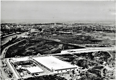
Photograph - Aerial view of the commencement of Appleton Dock, Aug 1925
Black and white aerial photo of Commencement of Appleton Dock and construction of new river berths, with caption, both pasted onto paper with chequered computer bordertransport - shipping, piers and wharves, yarra river, appleton dock -
Port Melbourne Historical & Preservation Society
Photograph - Sketch, Bay scene viewed from Newport area
Copy photograph of sketch: Bay scene viewed from Newport area, looking east across the Yarra River towards Sandridge and the Sugar Works, which stand out in the middle of the sketch. Ships are seen moving downstream under sail (one is under tow from a steamship) whilst others are at anchor in the BayB2, 8 on backnatural environment, transport - shipping -
 Bendigo Historical Society Inc.
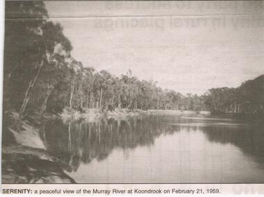
Newspaper - JENNY FOLEY COLLECTION: SERENITY
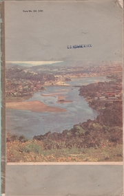
... : a peaceful view of the Murray river at Koondrook on February 21, 1959.... ''The way we were'' from 2003. Serenity: a peaceful view ...Bendigo Advertiser ''The way we were'' from 2003. Serenity: a peaceful view of the Murray river at Koondrook on February 21, 1959.newspaper, bendigo advertiser, the way we were -
 Bendigo Historical Society Inc.
Document - Various writings by John Ellison
... a notebook. Two others are on loose pages. The notebook has a view... others are on loose pages. The notebook has a view of a lake ...Writings on various topics. Some are glued inside a notebook. Two others are on loose pages. The notebook has a view of a lake/river with several small villages on the banks. location unknown. Topics are: "The Australian Aboriginals", ' The Great Pastland Movement", Problem of Urban Planning" and "the Plea of Youth".On the cover and on the first page a stamp: L.J. Ellison A.I.M.A.australian aborigines, pastoralist movement, urban planning -
 Bendigo Historical Society Inc.
Photograph - HARRY BIGGS COLLECTION: SHACKS
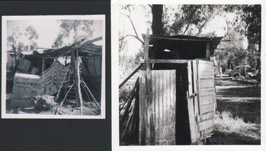
Two small photographs. 1, Building/shack in very bad condition, a cloth curtain is hanging across the front, an old cupboard is visible to the left. 2, An old wooden small building (Dunny?), there is a sheet of galvanized iron across the front, In the background can be seen a man and a 1930's vintage car.place, landscape view, site, camp on the river -
 Bendigo Historical Society Inc.
Postcard - GERTRUDE PERRY COLLECTION: POSTCARD MURRAY RIVER
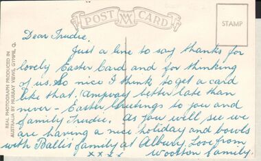
... for Easter card from the Woolton family. The postcard is a view.... The postcard is a view of the Murray river at Albury NSW. Postcard ...A black and white postcard to a Trudie thanking her for Easter card from the Woolton family. The postcard is a view of the Murray river at Albury NSW.postcard, photograph, murray river -
 Bay Steamers Maritime Museum
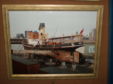
Photograph - Framed Photograph, S.T.Wattle up on blocks at 19 South Wharf at commencement of restoration. October 2009, 10/2009
Beginning of the long-awaited restoration by Bay Steamers volunteers. A very significant moment in the life of the Wattle as this was the first day of the major restoration project that commenced in October 2009 and continued to 2020. Prior to this restoration project there was a long lead up to find funding and resources to restore the Wattle and ensure that the ship was not scrapped. The majority of this preparation and restoration work was and continues to be completed by volunteers. Photograph shows the state of the vessel up on blocks and prior to the start of hull restoration in October 2009.Coloured photograph in gilded wooden frame shows Wattle viewed from her port quarter and facing the Yarra River.steamer wattle, steam tug, wattle, restoration, volunteers, bay steamers maritime museum, river yarra, port of melbourne -
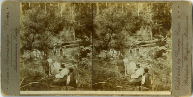 Yarra Ranges Regional Museum
Photograph, Rational Dress Picnic, Fernshaw, Vic Watt's River, c. 1895
This is an early stereoview by George Rose. The women in the picture wears 'Rational Dress', which referes to a dress reform during the late Victorian era. THe reform was particulally realted to womens undergarments which were modified to be more comfortable and less restrictive. Stereographic photo - Rational Dress Picnic, Fernshaw, VIC., Watts River Printed in brown along left edge : Rose's Stereoscopic Views,- / Australian Seriies. Printed in brown along right edge: Sold only by George Rose, - / Publisher, Windsor, Melbourne. Printed underneith image: 743, Rational Dress Picnic, Fernshaw, VIC, Watts Riverrose series, fernshaw, rational dress, watts river -
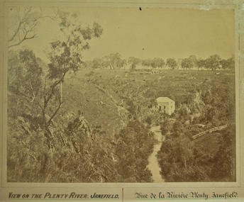 City of Whittlesea
Photograph (item) - Photographs - Landscapes, View on the Plenty River, Janefield
... View on the Plenty River, Janefield...View on the Plenty River, Janefield / Vue de la Riviere... melbourne View on the Plenty River, Janefield / Vue de la Riviere ...View on the Plenty River, Janefield / Vue de la Riviere Plenty - Janefield -
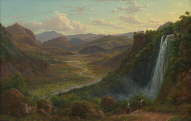 Benalla Art Gallery
Painting, Eugene VON GUERARD, The fall of the Veliono near Terni with the view up the Valley of the River Nera, 1885
Born: Vienna, Austria 1811; Arrived: Melbourne, Victoria, Australia 1852; Died: London, Middlesex England 1901RomanticismLedger Gift, 1984Rural valley and mountain landscape with two figures walking down a track beside a waterfall towards a river. Gold brushed gesso decorative edged timber frame.Recto: Signed and dated "Eug.V.Guérard / D. 85" in red oil in l.r.c of composition; Not titledpainting, landscape, river, cliff, mountain, figures, buildings, waterfall, sky, clouds -
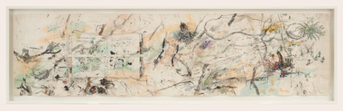 Bendigo Art Gallery
Work on paper, John WOLSELEY, The Language of Lizards, 2007-2008
l.r; Murray Sunset Wilderness, 2008, John Wolseleyaustralian artist, landscape, lizards, murray river, tree, flower, flora, abstract -
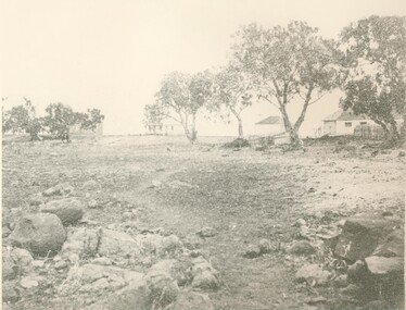
Tatura Irrigation & Wartime Camps Museum
Photograph, 1950
Taken by photographer for State Rivers and Water Supply Commission.Medium sized black and white photograph. General view of camp looking west (in 1950) Army huts spread across middle - right to leftvictorian state rivers and supply commission, camp 13, murchison, water commission camp -
Tatura Irrigation & Wartime Camps Museum
Photograph, Transport office Camp 13, 1950
Shows Army garrison huts in camp 13 Murchison. Taken by photographer for State Rivers and Water Supply Commission.Black and white photograph. Army huts - view looking down main street - transport office on left - poplars and telegraph pole rightvictorian state rivers and supply commission, camp 13, murchison, water commission camp, army garrison huts -
Tatura Irrigation & Wartime Camps Museum
Photograph, Goulburn Weir, 1890
Taken by photographer for State Rivers and Water Supply Commission.Medium sized black and white photograph. View across weir - channel outlet left - earth and rubble wall separates two concrete and iron structures of weir. Trees on bank beyond beyond, buildings scattered amongst trees.victoria state rivers and water supply commission, goulburn weir -
Tatura Irrigation & Wartime Camps Museum
Photograph, Goulburn Weir, 1890
Taken by photographer for State Rivers and Water Supply Commission.Medium sized black and white photograph. View across weir showing partially completed channel outlet. Partially completed brick control building on top of wall joining the weir and channel outlets, hourse, cart, and driver bottom right.victoria state rivers and water supply commission, goulburn weir -
Tatura Irrigation & Wartime Camps Museum
Photograph, Goulburn Weir, 1890
Taken by photographer for State Rivers and Water Supply Commission.Medium sized black and white photograph. View from south of weir under construction Two carpenter's trestles foreground Trees in mid distance background Canoe in middle dry channel in foregroundvictoria state rivers and water supply commission, goulburn weir -
Tatura Irrigation & Wartime Camps Museum
Photograph, Goulburn Weir, 1890
Taken by photographer for State Rivers and Water Supply Commission.Medium sized black and white photograph. View of concrete and steel weir structure - with water cascading down the spillway steps from West side. Thick foliage beyond on East bankgoulburn weir, victorian state rivers and supply commission -
Tatura Irrigation & Wartime Camps Museum
Photograph, May, 1888
Taken by photographer for State Rivers and Water Supply Commission.Medium sized black and white photograph. Weir wall of granite blocks nearing completion viewed from downstream. Construction camp of tents and sheds mid-picture beyond wall.goulburn weir, victorian state rivers and supply commission -
Tatura Irrigation & Wartime Camps Museum
Photograph, The Goulburn-Waranga Main Channel, 1957
Taken by the photographer for Victoria State Rivers and Water Supply Commission.Sepia photograph - dry mounted on cream cardboard. Wide view of water-filled channel, trees lining each bank Large photographAbove photo - "The Goulburn Waranga Main Channel"irrigation, goulburn, waranga, victoria state rivers and water supply commission, channel -
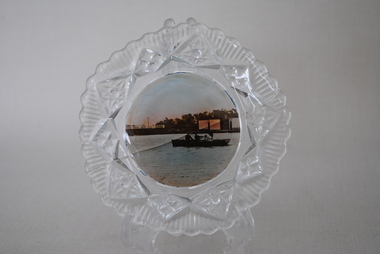 Anglesea and District Historical Society
View Ware Dish, Estimated 1920's
... Decorative glass surround. Plain centre with scenic view... glass surround. Plain centre with scenic view of Anglesea River ...Decorative glass surround. Plain centre with scenic view of Anglesea River, bridge and rowers. Crack across centre.anglesea, rowers, view ware -
 Lake Bolac & District Historical Society
Black and white photograph, "Lake Boloke" homestead and the dry shore-line of Lake Bolac, circa 1855
A very early view of the first blue-stone homestead and out-buildings at "Lake Boloke" station, established by Robert Patterson, believed taken in the early 1850's. The row of River red-gums indicates the shoreline of Lake Bolac which seems to be at least partially dry.lake bolac, lake boloke station, patterson