Showing 3383 items
matching run
-
 Glenelg Shire Council Cultural Collection
Photograph - Photograph - aerial view of Portland, c. 1954
Black and white aerial photograph of coastline around Portland. Black border, scale all sides, 5 rows of 3 't' at regular intervals. Right hand end of headland no longer visible. 50/50 ocean to land.Front: '784 - 151'- handwritten, white, border 'RUN A PORTLAND', printed, white, borderaerial photography, central portland, portland harbour, south west coastline -
 St Kilda Historical Society
Photograph - Photo map, 28/01/1951
One of a series of photo-maps produced for the Department of Crown Lands and Survey (1857-1983). For correlation with a current map, and access to other historical photo maps of Victoria, see the Historic Photo-Maps Index published by the Department of Environment, Land, Water and Planning at https://services.land.vic.gov.au/DELWPmaps/historical-photomaps/Black and white aerial photograph1424-118 534 Run 20 Lens 12" Melbourne Metropolitan 12150 18.1.51M639elwood, point ormond, elwood park, elsternwick park, elwood beach, 1951 -
 Melbourne Tram Museum
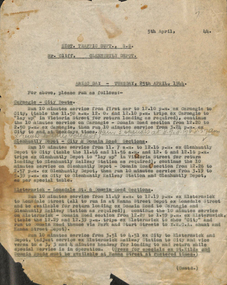
Document - Memorandum, Melbourne & Metropolitan Tramways Board (MMTB), "ANZAC Day - Tuesday 25th April 1944", 5/4/1944
ANZAC Day - Tuesday 25th April 1944 Memo from Dist Traffic Supt SS to Mr Cliff, Glenhuntly Depot, regarding tram arrangements for ANZAC Day. (single page only, subsequent pages missing)"Run 3 specials at 8.7 8.17 & 8.27am" "returns to city & depot" written in penciltrams, tramways, instructions, anzac day, glenhuntly depot -
 Melbourne Tram Museum
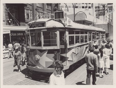
Photograph - Black & White Photograph/s, The Met, Jul. 1986
Photograph of Transport Art Tram No. 731, after conversion to a SW5, painted by Lesley Dumbrell in July 1986. Refer to vicsig.net website for dates, accessed 23/8/2013. Tram in Bourke St, with destination of Special. Has the CUB sponsorship sign behind the route number box. There was no driver in the cab at the time of the photograph. In the background are signs for Roger David and McEwans.In ink on rear of photo "731 on inaugural run as Arts Decorated Tram, City Mall"trams, tramways, transporting art, bourke st, decorated trams, tram 731 -
 Rosedale and District Historical Society
Feather Boa
Ostrich feather Boa, cream feathers with tassels on both ends, the feathers on either side run upwards and peak at the neck.world war one, france, 1918, wwi, ostrich feather, boa, cream in colour, miss jean millar, mrs jean lees, rosedale, gordon farley, war momento -
Glenelg Shire Council Cultural Collection
Slide - Slide - Cashmore Airport, Portland, 1980s
Coloured slide. Run-way site. Several road-making vehicles. Clouds of dust. Cashmore airport construction site.portland airport, cashmore airport, air travel, engineering, construction -
 Bendigo Historical Society Inc.
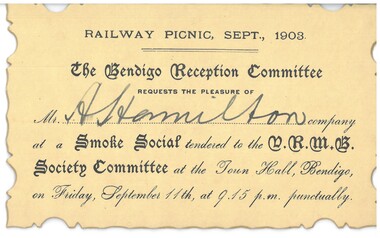
Document - HAMILTON COLLECTION: INVITATION TO A SMOKE SOCIAL, September 1903
Document. Invitation to Mr A Hamilton to a Smoke Social run by the Bendigo Reception Committee, Town Hall, Bendigo. September 1903.performing arts, elocution, invitation to a smoke social -
Whitehorse Historical Society Inc.
Article, Walk's healing power, 2008
Reconciliation walk (the Gaayip) is being run by Whitehorse Friends for Reconciliation.Reconciliation walk (the Gaayip) is being run by Whitehorse Friends for Reconciliation. Photo of Howard Tanky and Roseanne Hepburn at Blackburn LakeReconciliation walk (the Gaayip) is being run by Whitehorse Friends for Reconciliation.whitehorse friends for reconciliation, tanky, howard, hepburn, roseanne, blackburn lake -
 Lakes Entrance Historical Society
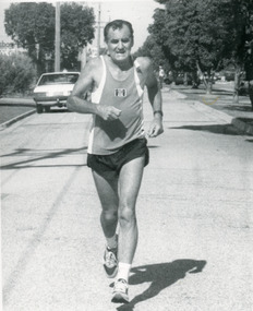
Photograph - Fun Run, Lakes Post Newspaper, 1993
number in album 03358.02Black and white photograph Alan Ferguson, winner male over 50 category, Fun Run. Lakes Entrance Victoriasports, charities -
 Kew Historical Society Inc
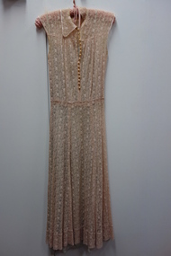
Clothing - Pink Ecru Needle-Run Lace Dress, 1930s
The Fashion & Design collection of the Kew Historical Society includes examples of women’s, men’s, children’s and infants’ clothing from the 18th, 19th and 20th centuries. Items in the collection were largely produced for, or purchased by women in Melbourne, and includes examples of outerwear, protective wear, nightwear, underwear and costume accessories.Three quarter length dress of ecru needle-run lace with pearl buttons at front to waist and green under slip.women's clothing, australian fashion - 1930s, cocktail dresses, lace dresses -
 Falls Creek Historical Society
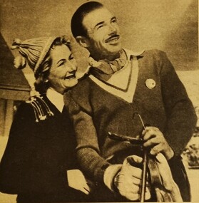
Newspaper - Australia's Playground of the Future
Australian Magazine (A.M.) published a special three page article about Falls Creek and the Bogong High Plains on 24th August 1954. The article was titled "Australia's playground of the future". Written by Muir Maclaren, it referred to the Bogong High Plains as a comparatively new and unexploited winter playground which could be one of the best snow resorts in the world. There were 13 huts which were at Falls Creek which were there due to "hard work, the grace of God, and the permission of the Victorian State Electricity Commission". A brief history of the Albury Ski Club Lodge was included. In 1954 the Lodge was run byLes Meikle and had the Club had a membership of 200 people. Lodges with accommodation established at this time, with the ability to house a total of 280 people, included Albury, Skyline, Bogong, Myrtleford, Hymans, Dawn, Galleon, Kiewa Valley, Snowden, Nelse, Moroma, Trowalla, St, Trinian's, Bowna and Nissen. The reporter also interviewed Skippy and Toni St. Elmo and gave a description of the tow and its fees. He outlined Toni's earlier background with the SEC and noted that Toni had recently named a peak in the area Mt.. Hillary in honour of the success of Edmund Hillary in conquering Mt. EverestThis article and accompanying images are significant because they capture early information about the Bogong High Plains, Falls Creek and its pioneers.A centre spread from a monthly publication featuring text and colour imagesBeneath photo Toni St. Elmo and his wife, Skippy, who run the ski tow and a ski school. Skippy won the Albury Club Club Championship against men.bogong high plains, skippy st. elmo, toni st. elmo -
Port Melbourne Historical & Preservation Society
Photograph - Irving children celebrate first run of the boat train, 1936
PORT PHILLIP CITY COLLECTION Black and white photograph ; "Irving children celebrate first run of the boat train 1936" on the back of the January page of the PMHPS 1999 calendar. Information about the Boat Train printed beside photograph. Station Pier building visible above the train, which is on its first runtransport - railways, transport - shipping, piers and wharves - station pier, families, celebrations fetes and exhibitions, laura irving mcgill -
 Ballarat Tramway Museum
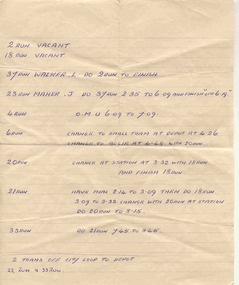
Document - Handwritten Notes, Tramcar operations, 1971?
Yields information about the rostering of crews possibly for a specific day, alterations to regular rosters/runs. Handwritten.Handwritten notes - undated - about the traffic arrangements, possibly for a particular day - gives 9 different run numbers, changes to run and details on starting and finishing times and what to change with. Exact context of use unknown - could have been the changes for a particular day towards the end of the services due to crew shortages.trams, tramways, timetables, sec, ballarat, crews -
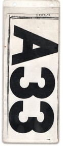 Melbourne Tram Museum
Functional object - Run Number Plate, The Met, Temporary South Melbourne A33, c1980?
Run Number plate - plastic envelope, two holes on the top, with a folded paper photocopied run number (temporary) possibly to replace a lost one. Printed and folded onto the rear of a tram depot information sheet. Used by South Melbourne Depot with number 33 - A33 to indicate which timetable the tram operated on.trams, tramways, mmtb, south melbourne depot, timetables -
 Ringwood and District Historical Society
Photograph, Composite Aerial Views of Ringwood, Victoria - 1972
Two composite black & white aerial photographs with north-facing view over Maroondah Highway, including Railway Station precinct, Civic Centre precinct, Eastland, Mount Dandenong Road, Bedford Road, Ringwood Street, Warrandyte Road, Mullum Road, Loughnan's Road.Department of Crown Lands and Survey. Maroondah Highway Project - Run 3 - 20.1.72 - 3,900' ASL. -
Glenelg Shire Council Cultural Collection
Photograph - Photograph - aerial view of Portland, c. 1954
Black and white aerial photograph of coastline around Portland. Black border, scale all sides, 5 rows of 3 't' at regular intervals. Ocean on left, land on rightFront: '607 - 54 ' - handwritten, white, border 'RUN 7' 'PORTLAND', printed, white, borderaerial photography, central portland, portland harbour, south west coastline -
Glenelg Shire Council Cultural Collection
Photograph - Photograph - aerial view of Portland coastline, c. 1954
Black and white aerial photograph of coastline around Portland. Black border, scale all sides, 5 rows of 3 't' at regular intervals. Mostly ocean, small area of land top left. See Other Information.Front: '820 - 47' - handwritten, white, border 'RUN 6' 'PORTLAND', printed, white, borderport of portland archives, aerial photography, portland harbour, south west coastline -
Glenelg Shire Council Cultural Collection
Photograph - Photograph - aerial view of Portland, c. 1954
Black and white aerial photograph of coastline around Portland. Black border, scale all sides, 5 rows of 3 't' at regular intervals. Half ocean, half land, separated by beach, further left than 8472Front: '607 - 91 ' - handwritten, white, border 'RUN - 6 PORTLAND', printed, white, borderaerial photography, central portland, portland harbour, south west coastline -
Glenelg Shire Council Cultural Collection
Photograph - Photograph - aerial view of Portland coastline, c. 1954
Black and white aerial photograph of coastline around Portland. Black border, scale all sides, 5 rows of 3 't' at regular intervals. 10% ocean, 90% land. See 'Other Information'Front: '820- 52' - handwritten, white, border 'RUN 6' 'PORTLAND', printed, white, borderport of portland, aerial photography, south west coastline -
Glenelg Shire Council Cultural Collection
Photograph - Photograph - aerial view of Portland, c. 1954
Black and white aerial photograph of coastline around Portland. Black border, scale all sides, 5 rows of 3 't' at regular intervals. 25% ocean, 75% land. See 'Other Information'Front: '820 - 50' - handwritten, white, border 'RUN 6' 'PORTLAND', printed, white, borderaerial photography, central portland, portland harbour, south west coastline -
Glenelg Shire Council Cultural Collection
Photograph - Photograph - aerial view of Portland, c. 1954
Black and white aerial photograph of coastline around Portland. Black border, scale all sides, 5 rows of 3 't' at regular intervals.Mostly ocean, strip of land down right hand edge and across bottom.Front: '607 - 55 ' - handwritten, white, border 'RUN 7 'PORTLAND', printed, white, borderaerial photography, central portland, portland harbour, south west coastline -
Glenelg Shire Council Cultural Collection
Photograph - Photograph - Aerial photograph of coastline around Portland, Victoria, c. 1954
Black and white aerial photograph of coastline around Portland. Black border, scale all sides, 5 rows of 3 't' at regular intervals. Bottom 20% ocean, rest land, separated by beach.Front: '607 - 88' - handwritten, white, border 'RUN - 6 PORTLAND', printed, white, border -
Glenelg Shire Council Cultural Collection
Photograph - Photograph - Aerial view of coastline around Portland, Victoria, c. 1954
Black and white aerial photograph of coastline around Portland. Black border, scale all sides, 5 rows of 3 't' at regular intervals. Top half is ocean, bottom half is ? beach; sand dunes, cliffs.Front: '607 - 61 ' - handwritten, white, border 'RUN 7 PORTLAND', printed, white, border -
Glenelg Shire Council Cultural Collection
Photograph - Photograph - aerial view of Portland, c. 1954
Black and white aerial photograph of coastline around Portland. Black border, scale all sides, 5 rows of 3 't' at regular intervals. Further along to left, almost straight 60/40 ocean to land.Front: '784 - 152' - handwritten, white, border 'RUN 7 A PORTLAND', printed, white, borderaerial photography, central portland, portland harbour, south west coastline -
Glenelg Shire Council Cultural Collection
Photograph - Photograph - aerial view of Portland, c. 1954
Black and white aerial photograph of coastline around Portland. Black border, scale all sides, 5 rows of 3 't' at regular intervals. Mostly ocean, section of land jutting out into it.Front: '607 - 41 ' - handwritten, white, border 'RUN 8' 'PORTLAND', printed, white, border -
Glenelg Shire Council Cultural Collection
Photograph - Photograph - aerial view of Portland, c. 1954
Black and white aerial photograph of coastline around Portland. Black border, scale all sides, 5 rows of 3 't' at regular intervals. Only 10% land visible, top rightFront: '784 - 155- handwritten, white, border 'RUN 7 A PORTLAND', printed, white, borderaerial photography, central portland, portland harbour, south west coastline -
Glenelg Shire Council Cultural Collection
Photograph - Photograph - aerial view of Portland, c. 1954
Black and white aerial photograph of coastline around Portland. Black border, scale all sides, 5 rows of 3 't' at regular intervals. 75/25 land to ocean. Further left than 8475, ?end of beach.Front: '607 - 94 ' - handwritten, white, border 'RUN - 6 PORTLAND', printed, white, borderaerial photography, central portland, portland harbour, south west coastline -
Glenelg Shire Council Cultural Collection
Photograph - Photograph - aerial view of Portland, c. 1954
Black and white aerial photograph of coastline around Portland. Black border, scale all sides, 5 rows of 3 't' at regular intervals. All oceanFront: '784 - 156- handwritten, white, border 'RUN 7 A PORTLAND', printed, white, borderaerial photography, central portland, portland harbour, south west coastline -
Glenelg Shire Council Cultural Collection
Photograph - Photograph - aerial view of Portland, c. 1954
Black and white aerial photograph of coastline around Portland. Black border, scale all sides, 5 rows of 3 't' at regular intervals. 50/50 land and oceanFront: '607 - 51 ' - handwritten, white, border 'RUN 7' 'PORTLAND', printed, white, borderaerial photography, central portland, portland harbour, south west coastline -
Glenelg Shire Council Cultural Collection
Photograph - Photograph - aerial view of Portland, c. 1954
Black and white aerial photograph of coastline around Portland. Black border, scale all sides, 5 rows of 3 't' at regular intervals. Mostly ocean, small area of land, top left.Front: '607 - 49 ' - handwritten, white, border 'RUN 8' 'PORTLAND', printed, white, borderaerial photography, central portland, portland harbour, south west coastline